Garmin GPSMAP 441s Support Question
Garmin GPSMAP 441s Support Question
Find answers below for this question about Garmin GPSMAP 441s.Need a Garmin GPSMAP 441s manual? We have 9 online manuals for this item!
Question posted by nibetha7 on June 22nd, 2014
Garmin 441s How To Connect Gfs 10
The person who posted this question about this Garmin product did not include a detailed explanation. Please use the "Request More Information" button to the right if more details would help you to answer this question.
Current Answers
Answer #1: Posted by TechSupport101 on June 23rd, 2014 1:56 AM
TechSupport101

Member since:
May 24th, 2013 Points: 12,171,305

Member since:
May 24th, 2013 Points: 12,171,305
Hi. There is an 'Installation Instruction' pdf doc and more here http://www.helpowl.com/manuals/Garmin/GPSMAP441s/114462
Related Garmin GPSMAP 441s Manual Pages
Installation Instructions - Page 3
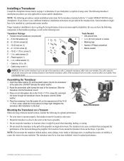
... to operate properly, the transducer must be spliced and connected to be jarred when launching, hauling, or storing....water to the center of the transducer
Mounting the Transducer on the 10-32 × 1.75 in . Place a 5 mm flat ...8226; Marine sealant
I - rubber washer (1) I
Notice: Do not cut the transducer lead or any existing (Garmin or non-Garmin) transducer cables. GPSMAP 400/500...
Installation Instructions - Page 8
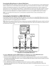
... 2000 Network
To connect a NMEA 2000-compatible GPSMAP 400/500 series chartplotter to your NMEA 2000 backbone, based on page 1 to determine whether your chartplotter is CANet compatible.
If more information. Using the CANet optimizes the performance of CANet-compatible devices, allowing sonar information from your local Garmin dealer or marine dealer.
Contact your...
Installation Instructions - Page 10

...;C)
Compass-Safe Distances:
Model Number
GPSMAP 526/536/546/556 GPSMAP 421/431/441/451 GPSMAP 521/531/541/551 GPSMAP 420/430/440/450 GPSMAP 520/530/540/550/525/535/545/555
Compass-Safe Distance 20 in. (50 cm)
26 in. (65) cm
30 in. (75 cm)
38 in . diagonal (10.6 cm), QVGA display with...
Technical Reference for Garmin NMEA 2000 Products - Page 3
... the UK, contact Garmin (Europe) Ltd. Technical Reference for the following products: ◦ GPSMAP® 4000/5000/6000/7000 Series chartplotters ◦ GPSMAP 700 Series chartplotters ◦ GPSMAP 4x1/5x1/5x6 Series chartplotters ◦ GMI™ 10 ◦ GPS 17x ◦ GFS™ 10 ◦ GRA™ 10 ◦ GET™ 10 ◦ GFL™ 10 ◦ GBT™ 10 ◦ GST...
Technical Reference for Garmin NMEA 2000 Products - Page 4
...)...19 GWS 10 (Garmin Wind Sensor)...20 GHP 10 (Marine Autopilot System)...20 GXM 51...21 VHF 200...21 VHF 300...21 AIS 300...22 AIS 600...22
NMEA 2000-Certified Sensor Configuration Information...23 GPS 17x (GPS Antenna)...23 GFS 10 (Garmin Fuel Sensor)...24 GRA 10 (Garmin Rudder Angle Adapter)...26 GET 10 (Garmin Engine Tilt Adapter)...27 GFL 10 (Garmin Fluid Level...
Technical Reference for Garmin NMEA 2000 Products - Page 5
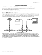
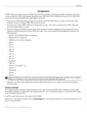
...2000 network is shown, and the parts included with a GFS 10 fuel sensor. The GFS 10 fuel sensor, as a power cable). Garmin sensors may also include additional NMEA 2000 components (such as...verify the installation. Garmin displays may be connected to an existing NMEA 2000 network on page 37 to add Garmin NMEA 2000 components, see page 8.
For a glossary of connected NMEA 2000 devices ...
Technical Reference for Garmin NMEA 2000 Products - Page 22
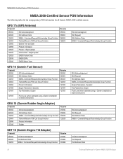
... ISO Request ISO Address Claim NMEA - Rapid Update COG & SOG - GPS 17x (GPS Antenna)
Transmit
Receive
059392 060928 126208 126464 126992 126996 129025 129026 129029 129539...Garmin chartplotter or marine instrument)
ISO Acknowledgement ISO Request ISO Address Claim NMEA-Command/Request/Acknowledge Group Function Engine Parameters - Command/Request/Acknowledge Group Function
GFS 10 (Garmin...
Technical Reference for Garmin NMEA 2000 Products - Page 28
....
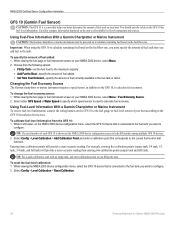
Using Fuel-Level Information With a Garmin Chartplotter or Marine Instrument To receive fuel-level information, connect the wiring harness on the GFS 10 to the fuel gauge or fuel-level...GFS 10 device that is connected to the fuel tank you want to configure. 2. Choose from the GFS 10: 1. Select either GPS Speed or Water Speed to specify which speed sensor is used on the GFS 10 for Garmin...
Technical Reference for Garmin NMEA 2000 Products - Page 29
... on your boat, specify which engine or tank is associated with each GFS 10 is connected to.
Choose 1 Coil or 2 Coil and repeat the gauge-type ...GFS 10 is shown on your Garmin chartplotter or marine instrument changes with the engine RPM, the GFS 10 could be detecting the wrong type of gauge. Select from the GFS 10 appears inaccurate, you can restore factory default settings to the GFS 10...
Owner's Manual - Page 13
... have an "s" series unit (such as a GPSMAP 441s) with a connected transducer to use sonar features.
• Chart/Sonar...Mariner's Eye 3D charts and Fish Eye 3D charts are available only if you use an SD card to transfer waypoints from any screen to return to the most-current version MapSource or HomePort by clicking Help > Check for Software Updates, or check the Garmin Web site at www.garmin...
Owner's Manual - Page 41

Navigating with NMEA 2000 compatible chartplotters (GPSMAP 441/441s, GPSMAP 536/536s, GPSMAP 541/541s, and GPSMAP 546/546s).
You can transfer BlueChart ... are connected to a compatible Garmin autopilot, you to damage from the SD card to the card. In addition to your PC. The BlueChart g2 Vision Mariner's Eye 3D is installed on BlueChart g2 Vision-compatible Garmin GPS units and...
Owner's Manual - Page 60
...fish only.
-sounds an alarm for large fish only. GPSMAP 400/500 Series Owner's Manual Turn the following alarms on or off: marine, tornado, severe
storm, flood, or flash flood.
Fish... and a connected Garmin XM WX weather receiver to view weather information (page 68).
1.
Setting Weather Alarms Note: You must be connected to an external fuel sensor, such as the Garmin GFS 10.
54
To...
Owner's Manual - Page 91

... 54 fuel 54 GPS accuracy 53 navigation ...MARPA 27 fishing information 73
GPSMAP 400/500 Series Owner's ...data 10 charts
detail 13 fish eye 3D 18 fishing 19 mariner's... eye 3D 16 navigation 8 settings 12 cleaning the unit 82
Clear User Data 44 close hauled wind gauge 42 collision alarm 26 colors, hazard 17 Color Scheme 61 Communications 51 Compass 36 compass rose 12 contact information, Garmin...
Owner's Manual - Page 92
...9 fuse 78
G
gain 61 Garmin Data Transfer 51 go to 28 GPS 5, 48, 78 GPS heading 42 Grid (North) 49...61 map datum 49 MapSource data 44 Mariner's Eye 3D
AIS 27 MARPA 27 mariner's eye 3D colors 17 mark current ...
No Zoom 61 numbers
customizing 37 overlay numbers 10 viewing 36
O
object information accessing 12
odometer 37...quick links i
GPSMAP 400/500 Series Owner's Manual Precision 51 Power/Backlight key ...
Owner's Manual - Page 13
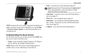
...: You must have an "s" series unit (such as a GPSMAP 441s) with a connected transducer or have a connection to a Garmin sounder via CANet to use a BlueChart g2 Vision SD card....to the Home screen.
• Charts-selects Navigation, Fishing, Perspective 3D, Mariner's Eye 3D, Fish Eye 3D, and Split Navigation charts.
Note: Mariner's Eye 3D, Fish Eye 3D, and Fishing charts are available only if you...
Owner's Manual - Page 39
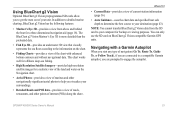
...if you are connected to a compatible Garmin autopilot, you are prompted to the information on...Mariner's Eye 3D-provides a view from above and behind the boat for a three-dimensional navigation aid (page 16).
In addition to your computer for a realistic view of the land and water on BlueChart g2 Vision-compatible Garmin GPS... the shore. The BlueChart g2 Vision Mariner's Eye 3D is more detailed than the...
Owner's Manual - Page 42

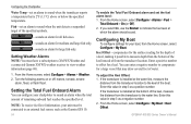
...Total Fuel Onboard-select to view Tidestation information.
36
GPSMAP 400/500 Series Owner's Manual
Tide-station information is...All Tanks-select when your tanks. • Fuel Economy-select either GPS Speed or Water Speed (using data from a speed wheel) for...Garmin GFS™ 10.
Viewing Information
To view fuel information, your unit must be connected to view the Tide Prediction Report...
Owner's Manual - Page 53
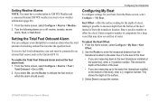
...the Home screen, select Configure > My Boat. GPSMAP 400/500 Series Owner's Manual
47 Setting the ...are measuring up to the water line (transducer installed on or off: marine, tornado, severe
storm, flood, or flash flood. Enter a negative ...
3. Setting Weather Alarms Note: You must be connected to an external fuel sensor, such as the Garmin GFS 10.
To enable the Total Fuel Onboard alarm and ...
Owner's Manual - Page 76
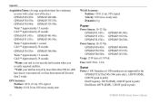
GPS Accuracy: Position: Appendix
Acquisition Times: (Average acquisition times for a stationary receiver with a clear view of the sky.) GPSMAP 430/430s GPSMAP 440/440s GPSMAP 530/530s GPSMAP 535/535s GPSMAP 530/540s GPSMAP 535/545s
Warm:* Approximately 15 seconds Cold:** Approximately 45 seconds
GPSMAP 431/431s GPSMAP 441/441s GPSMAP 531/531s GPSMAP 541/541s
Warm:* Approximately 1 second Cold:** ...
Owner's Manual - Page 77
...GPS accuracy has fallen outside of the dangerous target. AIS: Dangerous Target-shows the MMSI (Maritime Mobile Service Identity) of the userset value. Appendix
Battery Alarm-battery voltage has fallen below the value entered in 10...voltage allowed (or less) for your dealer or Garmin Product Support if the problem persists. Anchor Drag Alarm...
GPSMAP 400/500 Series Owner's Manual
71
Can't Write ...
Similar Questions

441s Transducer Wiring Diagram
Wires pulled out of plug connector red white black and green. Any idea which holes they go back in
Wires pulled out of plug connector red white black and green. Any idea which holes they go back in
(Posted by dlehtola 9 years ago)

Garmin 740 What Wires Are For Nmea 2000 And Gfs 10
(Posted by sriruthan 9 years ago)

How To Install A Garmin Gfs 10 Garmin 4212 Gps
(Posted by ezpras 10 years ago)

Does The Garmin 441s Have A Power Supply Cord
That You Can Use In The House?
(Posted by RBe5978875 10 years ago)

Hello, I Have The 441s, Sonar Option On Screen Has Disappeared. Help
Installed unit last year without issue. I store unit off boat for 3-4 months and when I put it back ...
Installed unit last year without issue. I store unit off boat for 3-4 months and when I put it back ...
(Posted by rightrigger 12 years ago)