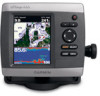
Garmin GPSMAP 441s Support Question
Garmin GPSMAP 441s Support Question
Find answers below for this question about Garmin GPSMAP 441s.Need a Garmin GPSMAP 441s manual? We have 9 online manuals for this item!
Question posted by dlehtola on July 12th, 2014
441s Transducer Wiring Diagram
Wires pulled out of plug connector red white black and green. Any idea which holes they go back in
Current Answers
Related Garmin GPSMAP 441s Manual Pages
Installation Instructions - Page 1
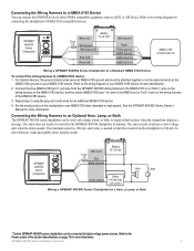
...contact Garmin Product Support. Install the wiring harness (page 6). 5.
Chartplotter ...transducer, if applicable (page 3). 4. Connect the chartplotter to the chartplotter (page 9). 7. Connect the cables to a NMEA 2000 network (optional, if applicable) (page 8). 6. Chartplotter GPSMAP 420/430/430x/440/440x/450 GPSMAP 520/525/530/535/540/545/550/555 GPSMAP 421/441/451 GPSMAP 431/531 GPSMAP...
Installation Instructions - Page 4
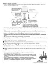
... extend 1/8 in. (3.2 mm) below an aluminum hull. Adjust the transducer assembly to electrical wires or other cable clamp.
8. Test the transducer installation after you pull it touches the mounting bracket, and then tighten 1/4 turn more . (Do not overtighten.)
5.
Apply marine sealant to be aligned parallel with the bottom when in . (25 mm) from seeping into...
Installation Instructions - Page 6
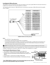
...
Wire Color
Red
Black
>
Blue
Brown
>
Grey
Violet
Wire Function
Power (10-32 Vdc*) Ground
(power and NMEA 0183) NMEA 0183 port 1 Tx (out)
NMEA 0183 port 1 Rx (in) NMEA 0183 port 2 Tx (out)
NMEA 0183 port 2 Rx (in)
> >
Green White Orange Yellow
CANet L (if applicable) CANet H (if applicable)
Accessory on Alarm low
To transducer (if applicable)
GPSMAP...
Installation Instructions - Page 7
... device. To select between visual and audible alerts, install a switch. GPSMAP 400/500 Series Chartplotter
+
-
The alarm circuit switches to use NMEA 0183 data (standard or high speed). GPSMAP 400/500 series chartplotter
Wire color
Fuse
3 A
Red
Black (ground)
+
- Refer to the wiring diagram for the GPSMAP 400/500 chartplotter to NMEA 0183-compatible devices. The alarm does...
Installation Instructions - Page 9
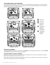
... the chartplotter may not be in the diagrams, but every possible connector type is necessary to carry the sonar signal from the sounder, the transducer must be used for all installations.
➋ ➌
➌ ➊➎
GPSMAP 421, 441, and 451
➌ ➊
GPSMAP 430x and 440x
➍ ➊
GPSMAP 420, 430, 431, 440, and 450
➋...
Installation Instructions - Page 10

... which the signal was turned off. Placing the transducer too deep can adversely affect the performance of the sky.) GPSMAP 420/430/440/450 (s) GPSMAP 520/530/540/550/525/535/545/555 (s): Warm*: Approximately 15 seconds Cold**: Approximately 45 seconds
GPSMAP 421/431/441/451 (s) GPSMAP 521/526/531/536/541/546/551/556 (s): Warm...
Installation Instructions - Page 11
... to peak); (1 kW transducers are NMEA 2000 certified.
130314
Actual Pressure
NMEA 0183, Version 3.01 Sentences: SDDBT, SDDPT, SDMTW, SDVHW, SDWPL
You can purchase complete information about National Marine Electronics Association (NMEA) format and sentences from: NMEA Seven Riggs Avenue Severna Park, MD 21146 USA www.nmea.org
GPSMAP 400/500 Series Installation...
Flush Mount Kit Instructions (Multilingual) - Page 2
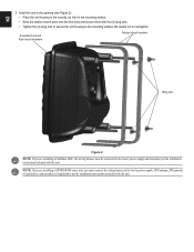
... mount hardware
Tension mount brackets
Wing nuts
Figure 2
NOTE: If you are installing a GPSMAP 400 series unit, you are installing a Fishfinder 400C, the wiring harness must connect the wiring harness to the boat's power supply, GPS antenna, XM antenna (if applicable), and transducer (if applicable) per the installation instructions included with the (4) wing nuts. •...
Owner's Manual - Page 3
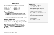
... Links
• Turning the Unit On or Off: page 3. • Acquiring GPS Satellite Signals: page 5. • Inserting and Removing SD Cards: page 6. &#... press SELECT again. GPSMAP 400/500 Series Owner's Manual Introduction
This manual includes information for the following products:
GPSMAP® 431/431s GPSMAP 531/531s GPSMAP 541/541s
GPSMAP 441/441s GPSMAP 536/536s GPSMAP 546/546s
Tips and...
Owner's Manual - Page 13
... www.garmin.com.
Note: You must have an "s" series unit (such as a GPSMAP 441s) with a connected transducer to use sonar features.
• Chart/Sonar-set up the screen to access all ...HomePort™, update to the Home screen.
• Charts-selects Navigation, Fishing, Perspective 3D, Mariner's Eye 3D, Fish Eye 3D, and Split Navigation charts. Getting Started
• Where To?-access...
Owner's Manual - Page 24
... a fish eye view (Fore, Aft, Port, or Starboard).
18
Sonar Cone (only available if sonar is present)-displays suspended targets (such as a GPSMAP 441s) with a connected transducer to use sonar features. Red indicates the largest targets and green indicates the smallest targets.
Use the Range keys to provide distance measurement. Targets are indicated by your...
Owner's Manual - Page 41

....
Navigating with NMEA 2000 compatible chartplotters (GPSMAP 441/441s, GPSMAP 536/536s, GPSMAP 541/541s, and GPSMAP 546/546s).
NOTE: Autopilot can transfer BlueChart g2 Vision data from static electricity. The BlueChart g2 Vision Mariner's Eye 3D is installed on the Navigation...you should ground yourself on BlueChart g2 Vision-compatible Garmin GPS units and when using HomePort.
Owner's Manual - Page 61
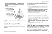
... water temperature measured in step 3.
6. This is not registering a speed, a "Speed Too Low" message appears.
55 GPSMAP 400/500 Series Owner's Manual
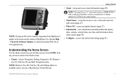
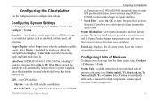
Configuring the Chartplotter
The temperature offset compensates for the temperature sensor of the transducer.
4.
Ensure that is connected to accept the number.
Setting the Water Temperature Offset You must have...
Owner's Manual - Page 63
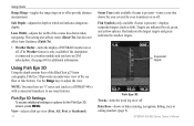
...Sonar
When connected to a transducer, the following chartplotters can be used as fishfinders:
GPSMAP 431s GPSMAP 441s GPSMAP 531s GPSMAP 536s GPSMAP 541s GPSMAP 546s
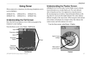
Understanding the Full ...transducer's sonar readings.
From the Home screen, select Sonar > Full Screen. The scale indicates what is beneath your boat. Depth of the sonar return. (When using the white default color scheme, red...
Owner's Manual - Page 84
... acquisition times for a stationary receiver with a clear view of the sky) GPSMAP 431/431s GPSMAP 441/441s GPSMAP 531/531s GPSMAP 541/541s
Warm:* Approximately 1 second Cold:** Approximately 38 seconds
GPSMAP 536/536s GPSMAP 546/546s
Warm:* Approximately 15 seconds Cold:** Approximately 38 seconds
*Warm: your...was turned off, or it has been turned off for more than 2 weeks. GPS Accuracy: Position:
Owner's Manual - Page 3
...products:
GPSMAP® 430/430s GPSMAP 431/431s GPSMAP 530/530s GPSMAP 531/531s GPSMAP 540/540s GPSMAP 541/541s
GPSMAP 440/440s GPSMAP 441/441s GPSMAP 535/535s GPSMAP 536/536s GPSMAP 545/545s GPSMAP 546... Chart, and press SELECT again.
GPSMAP 400/500 Series Owner's Manual
i Quick Links
• Turning the Unit On or Off: page 3. • Acquiring GPS Satellite Signals: page 5. •...
Owner's Manual - Page 8
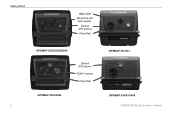
Getting Started
NMEA 2000® XM antenna with
audio adapter
External GPS antenna
Power/Data
GPSMAP 530/535/540/545
External GPS antenna GXM 31 antenna Power/Data
GPSMAP 430x/440x 2
GPSMAP 441/541
GPSMAP 430/431/440 GPSMAP 400/500 Series Owner's Manual
Owner's Manual - Page 13
...information (page 50).
Note: You must have an "s" series unit (such as a GPSMAP 441s) with a connected transducer or have a connection to a Garmin sounder via CANet to use a BlueChart g2 Vision...screen to return to the Home screen.
• Charts-selects Navigation, Fishing, Perspective 3D, Mariner's Eye 3D, Fish Eye 3D, and Split Navigation charts. Press HOME from MapSource®, ...
Owner's Manual - Page 47
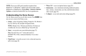
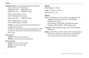
... darken the backlight. WAAS/EGNOS can provide more-accurate GPS position information. System Information-view system information and reset ...GPS-view GPS satellites.
• Skyview-view the GPS satellite constellation. • WAAS/EGNOS-toggle WAAS (in North America) or EGNOS
GPSMAP 400/500 Series Owner's Manual
Configuring the Chartplotter
(in Europe) on or off .
Auto Power (GPSMAP 431/441...
Owner's Manual - Page 76
GPS Accuracy: Position: Appendix
Acquisition Times: (Average acquisition times for a stationary receiver with a clear view of the sky.) GPSMAP 430/430s GPSMAP 440/440s GPSMAP 530/530s GPSMAP 535/535s GPSMAP 530/540s GPSMAP 535/545s
Warm:* Approximately 15 seconds Cold:** Approximately 45 seconds
GPSMAP 431/431s GPSMAP 441/441s GPSMAP 531/531s GPSMAP 541/541s
Warm:* Approximately 1 second Cold:** ...
Similar Questions

How Do I Go Into Simulation Mode On A Garmin Marine Gps Modle741xs
how do I use simulation mode on a garmin 741xs marine ver
how do I use simulation mode on a garmin 741xs marine ver
(Posted by Curthupp 6 years ago)


Does The Garmin 441s Have A Power Supply Cord
That You Can Use In The House?
(Posted by RBe5978875 10 years ago)

541s Marine Gps. Depth Not Reading Out.
Depth has been working since installed. Now blank. Is there an on off control for this that may have...
Depth has been working since installed. Now blank. Is there an on off control for this that may have...
(Posted by therad50 11 years ago)

Hello, I Have The 441s, Sonar Option On Screen Has Disappeared. Help
Installed unit last year without issue. I store unit off boat for 3-4 months and when I put it back ...
Installed unit last year without issue. I store unit off boat for 3-4 months and when I put it back ...
(Posted by rightrigger 12 years ago)