Garmin G600 Support Question
Garmin G600 Support Question
Find answers below for this question about Garmin G600.Need a Garmin G600 manual? We have 1 online manual for this item!
Question posted by anguscharlton on April 29th, 2014
Garmin Zumo 660 China Maps
It doesn't recognise the english words I in put for searching for cities. It seems to only accept chinese characters even when the keyboard is set to english.
Current Answers
Related Garmin G600 Manual Pages
Pilots Guide - Page 4
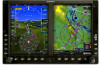
...enhance situational awareness.
Sec 6
Symbols
Sec 7
Appendix A Glossary
Sec 8
Index
Appendix B
ii
Garmin G600 Pilot's Guide
190-00601-02 Rev. WARNING: The displayed minimum safe altitudes (MSAs) are ... system. WARNING: The Garmin GDU 620 has a very high degree of surroundings during flight. Sec 5
& Alerts
Annun. WARNING: The altitude calculated by GPS receivers is not certified...
Pilots Guide - Page 5

... the aircraft based only upon ATC guidance or positive visual acquisition of the G600 Pilot's Guide. WARNING: To reduce the risk of the Garmin GDU 620 utilize GPS as an aid in data transmission and the relative age of all GPS equipment. Portions of unsafe operation, carefully review and understand all NAVAIDs, information presented...
Pilots Guide - Page 6

...must accept any interference received, including interference that is very sensitive to skin oils, waxes, and abrasive cleaners.
Sec 6
Symbols
Sec 7
Appendix A Glossary
Sec 8
Index
Appendix B
iv
Garmin G600 Pilot...feet away from GPS repeaters operating inside nearby hangars can cause an intermittent loss of the interference should only be made by an authorized Garmin service center....
Pilots Guide - Page 9

... Using the Soft Key Controls 1-15 1.3.3 System Settings 1-16 1.3.4 Display Backlighting 1-19 1.3.5 Dual GDU 620 Installations 1-19 1.3.5.1 Crossfill Information 1-19 1.3.5.2 Crossfill Selection 1-20
2 Primary Flight Display (PFD 2-1 2.1 PFD Soft Key Map 2-2 2.2 Airspeed Indicator 2-2
2.2.1 Markings 2-3
190-00601-02 Rev. B
Garmin G600 Pilot's Guide
vii
Sec 6
Annun.
& Alerts
Sec...
Pilots Guide - Page 10
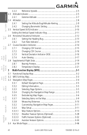
...3-10 3.3.2 Customizing Navigation Map Pages 3-11 3.3.3 Map Setup 3-11 3.3.3.1 Map Feature Options 3-13 3.3.3.2 Weather Feature Options (Optional 3-28 3.3.3.3 Traffic Feature Options (Optional 3-32 3.3.3.4 Aviation Feature Options 3-33 3.4 Aux Mode Pages 3-46
& Alerts
Annun. B Sec 6
Symbols
Sec 7
Appendix A Glossary
Sec 8
Index
Appendix B
viii
Garmin G600 Pilot's Guide
190-00601...
Pilots Guide - Page 12

...4.4.1 Using XM Satellite Weather Products 4-24 4.4.2 Customizing the XM Weather Map 4-24 4.4.3 XM Weather Symbols and Product Age 4-27 4.4.4 Weather Legends...4-39 4.4.10 SIGMETs and AIRMETs 4-41 4.4.11 METARs 4-43 4.4.12 Surface Analysis and City Forecast 4-45 4.4.13 Freezing Level 4-48 4.4.14 Winds Aloft 4-50 4.4.15 County Warnings...Appendix B
x
Garmin G600 Pilot's Guide
190-00601-02 Rev.
Pilots Guide - Page 13

B
Garmin G600 Pilot's Guide
xi Foreword Sec 1 System
Sec 2
PFD
Sec 3
MFD
Sec 4
Hazard
Avoidance ...Alerts 6-1 6.1 Alerts...6-1 6.2 System Status 6-8
7 Symbols 7-1 7.1 Map Page Symbols 7-1 7.2 SafeTaxi Symbols 7-2 7.3 Traffic Symbols 7-2 7.4 Terrain Obstacle Symbols 7-3 7.5 Basemap Symbols 7-4 7.6 Map Toolbar Symbols 7-4 7.7 XM Weather Toolbar Symbols 7-5 7.8 Miscellaneous Symbols...
Pilots Guide - Page 15

...Glossary Appendix A
Figure 1-1 G600 System (LRU Configuration)
The system consists of the G600 Avionics Display System. B
Garmin G600 Pilot's Guide
1-1
Appendix... 480, CNX80, GNS 400W series, or GNS 500W series GPS
190-00601-02 Rev. In normal operating mode, the Primary...The G600 system is an integrated display system that presents primary flight instrumentation, navigation, and a moving map ...
Pilots Guide - Page 16

...set of sub-units or Line Replaceable Units (LRUs).
Sec 6
Symbols
Sec 7
Appendix A Glossary
Sec 8
Index
Appendix B
1-2
Garmin G600... Pilot's Guide
190-00601-02 Rev. LRUs have a modular design and can be installed directly behind the instrument panel or in the G600 system. The G600...the operation of the G600 system. B Features Avoidance
Hazard
Sec 4
Additional
...
Pilots Guide - Page 17
... systems and also provides an HSI for navigation.
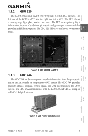
The MFD shows a moving map, flight plan, weather, and more. The PFD shows primary flight information, in... provides pressure altitude, airspeed, vertical speed, and OAT information to the G600 system. Figure 1-3 GDC 74A Air Data Computer
190-00601-02 Rev. B
Garmin G600 Pilot's Guide
1-3
Appendix B
Index Foreword
1.1.2 GDU 620
The GDU...
Pilots Guide - Page 18

...advanced tilt sensors, accelerometers, and rate sensors. The GRS 77 also utilizes GPS data forwarded from the GRS 77 and communicates with both the GDC 74A Air...unit that provides aircraft attitude information to determine aircraft magnetic heading. Figure 1-5 GMU 44 Magnetometer
1-4
Garmin G600 Pilot's Guide
190-00601-02 Rev. B
Appendix A Glossary
Sec 8
Index
Appendix B Foreword
...
Pilots Guide - Page 28
...Map Page.
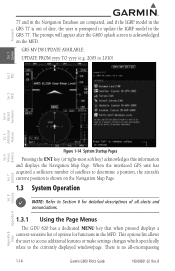
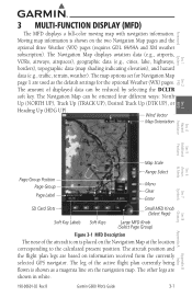
1.3 System Operation
NOTE: Refer to update the IGRF model in the GRS 77. GRS MV DB UPDATE AVAILABLE. B
Index
Appendix B This options list allows the user to access additional features or make settings... for detailed descriptions of all -encompassing
1-14
Garmin G600 Pilot's Guide
190-00601-02 Rev.
When the interfaced GPS unit has acquired a sufficient number of satellites ...
Pilots Guide - Page 53

...
Symbols
Figure 2-27 Vertical Deviation Indicator (GPS Source)
2.7.4 Auto-Slewing
The G600 system is designed to interface with GNS navigator units and also manage up to Auto-Slew. B
Garmin G600 Pilot's Guide
2-17
Sec 8
Glossary ...(this can be verified by the approach waypoints appearing on the GDU620 MFD Nav Map Page or FPL Page).
2) The appropriate frequency is in the active window in...
Pilots Guide - Page 59
...airports,
VORs, airways, airspaces), geographic data (e.g., cities, lake, highways,
borders), topographic data (map shading indicating elevation), and hazard
data (e.g., traffic, terrain, weather).
The leg of the active flight plan currently being flown is shown as the default settings for the optional Weather (WX) pages. B
Garmin G600 Pilot's Guide
3-1
Appendix B
Index
The other...
Pilots Guide - Page 72

... next option.
3-14
Garmin G600 Pilot's Guide
190-00601-02 Rev. With "Map Setup" highlighted, press ENT.
System
Sec 1
PFD
Sec 2
MFD
Sec 3
Features Avoidance
Hazard
Sec 4
Additional
Sec 5
& Alerts
Annun. Sec 6
Symbols
Sec 7
Appendix A Glossary
Sec 8
Figure 3-16 Navigation Map "North Up At" Orientation Range Selection
3) Press ENT to accept the displayed value. The...
Pilots Guide - Page 127

...190-00601-02 Rev. B
Garmin G600 Pilot's Guide
4-1 A ...Map and Terrain pages.
GTX 33/330 Transponder
required) Weather
• GDL 69/69A XM® Satellite Weather
4.1 Terrain
During power-up of potential hazards to operate properly: • The system must have a valid 3-D GPS position solution. • The system must have a valid terrain/obstacle/airport terrain database.
Garmin...
Pilots Guide - Page 150

... the "Weather Setup" option. The cursor flashes on the ground and the current GPS time. If more than half of the expiration time has elapsed from the time ...Wx Data Link Map pages are refreshed at specific intervals (defined in the Map Page Group. Sec 6
Symbols
Sec 7
Appendix A Glossary
Sec 8
Index
Appendix B
Figure 4-11 Weather Page Menu Options
4-24
Garmin G600 Pilot's Guide
190...
Pilots Guide - Page 222

...Appendix A Glossary
Sec 8
Index
Appendix B
7-6
Garmin G600 Pilot's Guide
190-00601-02 Rev. B Foreword
System
Sec 1
PFD
Sec 2
MFD
Sec 3
Features Avoidance
Hazard
Sec 4
7.8 Miscellaneous Symbols
Symbol
Description Default Aircraft (ownship)
High Wing Aircraft
Jet Aircraft
Default Map Cursor Measuring Cursor
Wind Vector (w/ valid GPS solution)
Parallel Track Waypoint Restricted...
Pilots Guide - Page 225
...Garmin Air Data Computer Garmin Satellite Data Link Garmin Display Unit geographic Global Navigation Satellite Landing System Garmin Audio Panel System Greenwich Mean Time Garmin Magnetometer Unit Global Positioning System GPS... set directional gyro Horizontal Figure of Merit mercury hectopascal Horizontal Protection Level High-Speed Data Bus Horizontal Situation Indicator Hertz
Garmin G600 ...
Pilots Guide - Page 236

... Glossary
Sec 8
Index
Appendix B
B-2
Garmin G600 Pilot's Guide
190-00601-02 Rev. ...,
5-1, 5-19 GDL 69 troubleshooting 5-24 GDU 620 1-3 GDU 1040 1-1 Glideslope 2-16 Glossary 8-1 GMU 44 1-4 GPS altitude 4-6 GPSS 5-26
Ground pointer 2-6 GRS 77 1-1, 1-4 GTP 59 1-5, 2-21 GTX 33 1-2 GTX 330/... 2-14
M
Magnetometer 1-4, 1-7 Map 3-4 Map orientation 3-13 Map panning 3-8 Map pointer 3-8
& Alerts
Annun.
Similar Questions

Automatically Stay On Even With Lost Of External Power Source
Hello, I am currently using the GPSMAP 86sci. I am using it for long duration route tracking where I...
Hello, I am currently using the GPSMAP 86sci. I am using it for long duration route tracking where I...
(Posted by nazihahms 1 year ago)


If Map Has Error In Position , How To Calibrate This Map Error By Using What?
(Posted by minaungnav 11 years ago)

Will The Following Garmin Simulators Work On My Apple Applepro Laptop G500,g600
I have an Apple MacbooPro and Ipad3. I am a flight Instructor specializing in Instrument Rating trai...
I have an Apple MacbooPro and Ipad3. I am a flight Instructor specializing in Instrument Rating trai...
(Posted by hstaub 11 years ago)