
Owners Manual
Page 4
... a Track Log 67 Saving a route 67 Loading a saved route 68 4: Reference book (Advanced mode) 69 Map screen 69 Icons on the map 73 Battery, GPS position quality and Vehicle type indicator 73 Status indicator strip 75 Next two route events (Turn Preview fields) 76 Objects on the map 78 Streets and roads 78 3D object types 78 Elements of the active route 78 Detour menu 80 Cursor menu 81 Position menu 83 Route information screen 84 Trip information screen...
... a Track Log 67 Saving a route 67 Loading a saved route 68 4: Reference book (Advanced mode) 69 Map screen 69 Icons on the map 73 Battery, GPS position quality and Vehicle type indicator 73 Status indicator strip 75 Next two route events (Turn Preview fields) 76 Objects on the map 78 Streets and roads 78 3D object types 78 Elements of the active route 78 Detour menu 80 Cursor menu 81 Position menu 83 Route information screen 84 Trip information screen...

Owners Manual
Page 5
Find menu Route menu Manage menu Manage saved route Manage History Manage Track Logs Manage Favourites Manage POIs Managed Saved Search Criteria User Data management Settings Menu Map Screen settings Sound settings Route Planning options Regional settings Navigation settings Warning settings GPS settings TMC settings Menu settings Device settings Track Log settings 5: Bluetooth 6: Glossary Warranty 93 94 95 95 96 96 97 98 100 100 101 103 104 105 107 109 110 112 112 113 113 114 116 126 130 Page 5
Find menu Route menu Manage menu Manage saved route Manage History Manage Track Logs Manage Favourites Manage POIs Managed Saved Search Criteria User Data management Settings Menu Map Screen settings Sound settings Route Planning options Regional settings Navigation settings Warning settings GPS settings TMC settings Menu settings Device settings Track Log settings 5: Bluetooth 6: Glossary Warranty 93 94 95 95 96 96 97 98 100 100 101 103 104 105 107 109 110 112 112 113 113 114 116 126 130 Page 5
Owners Manual
Page 14
... with your GPS position; Tap the screen buttons and the map with TRAX436 TRAX436 is a navigation system that TRAX436 recommended, TRAX436 changes the instructions accordingly. others cannot track you deviate from the route that helps you start your destination with a connected GPS receiver. TRAX436 has a Safety Mode: if you turn on Safety Mode, you cannot change something in the deployment zone of an airbag or where it is important that you operate TRAX436 before...
... with your GPS position; Tap the screen buttons and the map with TRAX436 TRAX436 is a navigation system that TRAX436 recommended, TRAX436 changes the instructions accordingly. others cannot track you deviate from the route that helps you start your destination with a connected GPS receiver. TRAX436 has a Safety Mode: if you turn on Safety Mode, you cannot change something in the deployment zone of an airbag or where it is important that you operate TRAX436 before...
Owners Manual
Page 16
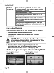
... To Speech. To use the Spoken Street Names feature you need to the bottom left corner on any screen. Later you can change the language or switch between the two operating modes in cases like: Moving the handle on any screen. Moving the map: grab the map, and move it in Advanced mode: Page 16 After this, the Navigation menu appears and you...
... To Speech. To use the Spoken Street Names feature you need to the bottom left corner on any screen. Later you can change the language or switch between the two operating modes in cases like: Moving the handle on any screen. Moving the map: grab the map, and move it in Advanced mode: Page 16 After this, the Navigation menu appears and you...
Owners Manual
Page 17
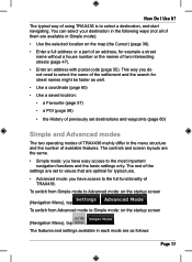
... the number of TRAX436. To switch from Advanced mode to the full functionality of available features. The controls and screen layouts are as well. • Use a coordinate (page 60) • Use a saved location: • a Favourite (page 57) • a POI (page 58) • the History of previously set to values that are set destinations and waypoints (page 60) Simple and Advanced modes The two operating modes of using TRAX436 is...
... the number of TRAX436. To switch from Advanced mode to the full functionality of available features. The controls and screen layouts are as well. • Use a coordinate (page 60) • Use a saved location: • a Favourite (page 57) • a POI (page 58) • the History of previously set to values that are set destinations and waypoints (page 60) Simple and Advanced modes The two operating modes of using TRAX436 is...
Owners Manual
Page 19
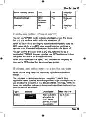
... you use it Tap it to initiate a function, to open a new screen, or to operate) or on or off . How to use the controls. When the device is switched off at any time. Page 19 Type Button Example Description Tap it once. Otherwise, TRAX436 saves your selections and applies the new settings without confirmation as soon as the GPS receiver has determined your data or settings.
... you use it Tap it to initiate a function, to open a new screen, or to operate) or on or off . How to use the controls. When the device is switched off at any time. Page 19 Type Button Example Description Tap it once. Otherwise, TRAX436 saves your selections and applies the new settings without confirmation as soon as the GPS receiver has determined your data or settings.

Owners Manual
Page 23
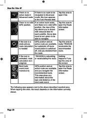
... coordinate and the list of nearby POIs will be displayed. • It is available and you want to open the Cursor menu. 4. You only need to the GPS position. Most of inactivity. Page 23 Tap . Manipulating the map Position markers on the map: • Current GPS position: (page 35) • Selected location (Cursor): (page 36) The following controls help you modify the map view to...
... coordinate and the list of nearby POIs will be displayed. • It is available and you want to open the Cursor menu. 4. You only need to the GPS position. Most of inactivity. Page 23 Tap . Manipulating the map Position markers on the map: • Current GPS position: (page 35) • Selected location (Cursor): (page 36) The following controls help you modify the map view to...
Owners Manual
Page 28
... mode If there is calculating or recalculating the route. If the icon is a static picture, route calculation is needed GPS position and an active route are available, and you deviated from the route. Tap this area to open the Route Information screen. There is switched off, and you navigate the recommended route. If an active route exists, and there is in the Turn Preview field. Next route event (next manoeuvre) GPS position...
... mode If there is calculating or recalculating the route. If the icon is a static picture, route calculation is needed GPS position and an active route are available, and you deviated from the route. Tap this area to open the Route Information screen. There is switched off, and you navigate the recommended route. If an active route exists, and there is in the Turn Preview field. Next route event (next manoeuvre) GPS position...
Owners Manual
Page 32
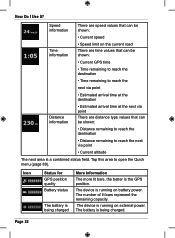
... reach the next via point • Estimated arrival time at the destination Distance information • Estimated arrival time at the next via point • Current altitude The next area is the GPS position. How Do I Use It? Speed information There are speed values that can be shown: • Current speed Time information • Speed limit on external power. The number of lit bars represent the remaining capacity.
... reach the next via point • Estimated arrival time at the destination Distance information • Estimated arrival time at the next via point • Current altitude The next area is the GPS position. How Do I Use It? Speed information There are speed values that can be shown: • Current speed Time information • Speed limit on external power. The number of lit bars represent the remaining capacity.
Owners Manual
Page 35
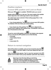
... 3D mode, the button appears. How Do I Use It? The exact location of the route. Page 35 Tap it plays the voice instructions and displays the turn preview icons according to the GPS position and re-enable Track-up map orientation (automatic map rotation). The direction of the following: • a Favourite • a Road Safety Camera • a POI • a map marker Pin Return to suppress GPS position errors. Position markers Current GPS position...
... 3D mode, the button appears. How Do I Use It? The exact location of the route. Page 35 Tap it plays the voice instructions and displays the turn preview icons according to the GPS position and re-enable Track-up map orientation (automatic map rotation). The direction of the following: • a Favourite • a Road Safety Camera • a POI • a map marker Pin Return to suppress GPS position errors. Position markers Current GPS position...

Owners Manual
Page 45
... do not need a simple route (a route with only one destination, without GPS reception (available in route planning. The TMC feature is available. The moment TRAX436 receives traffic information that it is a fee for broadcasting real-time traffic and weather information. TMC requires subscription to set up -to-date traffic conditions. How Do I Use It? TMC (Traffic Message Channel) TRAX436 can provide you can change the settings related to TMC, or select a specific radio station...
... do not need a simple route (a route with only one destination, without GPS reception (available in route planning. The TMC feature is available. The moment TRAX436 receives traffic information that it is a fee for broadcasting real-time traffic and weather information. TMC requires subscription to set up -to-date traffic conditions. How Do I Use It? TMC (Traffic Message Channel) TRAX436 can provide you can change the settings related to TMC, or select a specific radio station...
Owners Manual
Page 68
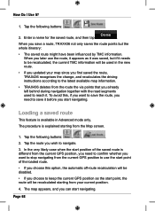
... first saved the route, TRAX436 recognises the change, and recalculates the driving instructions according to save a route, TRAX436 not only saves the route points but the whole itinerary: • The saved route might have been influenced by TMC information. Loading a saved route This feature is different from your map since you updated your current position. 4. In the very likely case when the start navigating. How Do I Use It? 1. Tap the following buttons: , , . 2. Enter...
... first saved the route, TRAX436 recognises the change, and recalculates the driving instructions according to save a route, TRAX436 not only saves the route points but the whole itinerary: • The saved route might have been influenced by TMC information. Loading a saved route This feature is different from your map since you updated your current position. 4. In the very likely case when the start navigating. How Do I Use It? 1. Tap the following buttons: , , . 2. Enter...
Owners Manual
Page 69
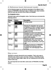
..., changing or deleting it or parts of them are available. Managing the behaviour of TRAX436, for the phone number of the map. Find Route Manage Settings Selecting the destination (for example an address or a POI) or using the search engine of TRAX436 is primarily intended for land navigation. The most important and most often used languages or the warnings. Managing user data, such as saved locations (POIs, Favourites, Pins...
..., changing or deleting it or parts of them are available. Managing the behaviour of TRAX436, for the phone number of the map. Find Route Manage Settings Selecting the destination (for example an address or a POI) or using the search engine of TRAX436 is primarily intended for land navigation. The most important and most often used languages or the warnings. Managing user data, such as saved locations (POIs, Favourites, Pins...

Owners Manual
Page 72
... 3D mode, automatic map rotation is also re-enabled. Tap&hold the button to set the zoom limits of the buttons to set its value to the current zoom level, or to reset it to its original value. Current GPS position (on nearest road) Cursor (selected map location) Lane information Tap&hold any of Smart Zoom. Tap this button to move the map back to fix, predefined...
... 3D mode, automatic map rotation is also re-enabled. Tap&hold the button to set the zoom limits of the buttons to set its value to the current zoom level, or to reset it to its original value. Current GPS position (on nearest road) Cursor (selected map location) Lane information Tap&hold any of Smart Zoom. Tap this button to move the map back to fix, predefined...

Owners Manual
Page 73
..., and a button that opens the Quick menu. The battery is full. Most of the device. The battery part shows information about the rechargeable battery of them also function as follows: • GPS position quality • Battery status • Vehicle type used for route calculation • Sound status (muted or enabled) • Track log recording status • TMC reception and processing status • Bluetooth connection and communication status Battery, GPS position quality...
..., and a button that opens the Quick menu. The battery is full. Most of the device. The battery part shows information about the rechargeable battery of them also function as follows: • GPS position quality • Battery status • Vehicle type used for route calculation • Sound status (muted or enabled) • Track log recording status • TMC reception and processing status • Bluetooth connection and communication status Battery, GPS position quality...
Owners Manual
Page 88
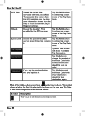
... the GPS receiver. Shows the speed limit of the current street if the map contains it can be set manually in one of the Trip Data fields. Tap this field to change the content of the Trip Data fields. This symbol shows whether the field it on the map screen in Regional settings. If you tap the previous button, this field to show it on this button to show information...
... the GPS receiver. Shows the speed limit of the current street if the map contains it can be set manually in one of the Trip Data fields. Tap this field to change the content of the Trip Data fields. This symbol shows whether the field it on the map screen in Regional settings. If you tap the previous button, this field to show it on this button to show information...

Owners Manual
Page 94
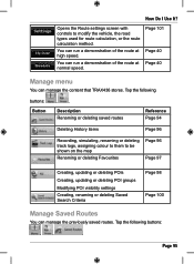
... the active route with useful route data. Page 68 Page 94 Page 60 Page 60 Page 57 Route menu Save, load and edit your destination by entering its route points Page 66 (start point, via points and destination). Button Description Opens a screen with all its coordinates. Reference Page 84 You can load a previously saved route for navigation. Page 67 You can browse the driving instructions that you have already entered in TRAX436...
... the active route with useful route data. Page 68 Page 94 Page 60 Page 60 Page 57 Route menu Save, load and edit your destination by entering its route points Page 66 (start point, via points and destination). Button Description Opens a screen with all its coordinates. Reference Page 84 You can load a previously saved route for navigation. Page 67 You can browse the driving instructions that you have already entered in TRAX436...
Owners Manual
Page 95
... Renaming or deleting saved routes Reference Page 94 Deleting History items Page 96 Recording, simulating, renaming or deleting track logs, assigning colour to them to modify the vehicle, the road types used for route calculation, or the route calculation method. Page 95 Tap the following buttons: Button , . Tap the following buttons: , , . You can run a demonstration of the route at normal speed. Opens the Route settings screen with controls to be...
... Renaming or deleting saved routes Reference Page 94 Deleting History items Page 96 Recording, simulating, renaming or deleting track logs, assigning colour to them to modify the vehicle, the road types used for route calculation, or the route calculation method. Page 95 Tap the following buttons: Button , . Tap the following buttons: , , . You can run a demonstration of the route at normal speed. Opens the Route settings screen with controls to be...
Owners Manual
Page 108
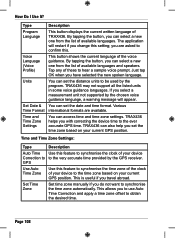
... GPS receiver. Page 108 You can select a new one from the list of available languages and speakers. TRAX436 may not support all the listed units in some voice guidance languages. By tapping the button, you with correcting the device time to confirm this feature to synchronise the time zone of the clock of available languages. Time and Time Zone Settings: Type Description Auto Time Use this setting...
... GPS receiver. Page 108 You can select a new one from the list of available languages and speakers. TRAX436 may not support all the listed units in some voice guidance languages. By tapping the button, you with correcting the device time to confirm this feature to synchronise the time zone of the clock of available languages. Time and Time Zone Settings: Type Description Auto Time Use this setting...

Owners Manual
Page 118
You should set up your navigator automatically in the future. Touch to your phone to allow connecting to exit the pairing procedure. Page 118 How Do I Use It? About to connect to initiate connection with Bluetooth device. Pairing is finished. See your phone for more details. If your phone requires you to specify a password, enter: 1234 Touch to your phone manual for the first time.
You should set up your navigator automatically in the future. Touch to your phone to allow connecting to exit the pairing procedure. Page 118 How Do I Use It? About to connect to initiate connection with Bluetooth device. Pairing is finished. See your phone for more details. If your phone requires you to specify a password, enter: 1234 Touch to your phone manual for the first time.


