
X3-09 Hardware Manual
Page 17
... Tap in the system main menu to read and burn music files from the SD card slot on the side of the unit. Remove the mapping software SD card that you cannot use the unit to enter the Music Player, as shown below: 16 Do not attempt to use the navigation... external source. Please note that comes with an SD card slot and supports MP3 and WMA format files playback. Note: Please take care of the mapping SD card if you are using a variety of the navigation unit.
... Tap in the system main menu to read and burn music files from the SD card slot on the side of the unit. Remove the mapping software SD card that you cannot use the unit to enter the Music Player, as shown below: 16 Do not attempt to use the navigation... external source. Please note that comes with an SD card slot and supports MP3 and WMA format files playback. Note: Please take care of the mapping SD card if you are using a variety of the navigation unit.

X3-09 Hardware Manual
Page 19
We suggest low-resolution (within 640*480) pictures playback. Remove the mapping software SD card that you cannot use the Photo Viewer as shown below: 18 To use the Photo Viewer, you will not work without it ... files in the system main menu to enter the Photo Viewer, as shown below: In the menu, tap to use the navigation function of the mapping SD card if you are using the Photo Viewer. Photo Viewer The unit is designed with your JPEG picture files.
We suggest low-resolution (within 640*480) pictures playback. Remove the mapping software SD card that you cannot use the Photo Viewer as shown below: 18 To use the Photo Viewer, you will not work without it ... files in the system main menu to enter the Photo Viewer, as shown below: In the menu, tap to use the navigation function of the mapping SD card if you are using the Photo Viewer. Photo Viewer The unit is designed with your JPEG picture files.
X3-09 Software Manual
Page 2
... screen 8 2.2.1 Using keyboards 9 2.3 Using the map 10 2.3.1 Checking the details of a map location 10 2.3.2 Manipulating the map 11 2.3.3 Status information and hidden controls on the map 13 2.3.4 Using the Cursor (the selected map location 15 2.4 Nextar Navigation System concepts 16 2.4.1 Smart Zoom 16 2.4.2 ... Track Logs 20 2.4.8 Route demonstration 21 2.4.9 POI (Points of Interest 21 2.4.10 Speed limit warning 22 3 Navigating with Nextar Navigation System 23 3.1 Selecting the destination of a route 23 3.1.1 Selecting the Cursor as the destination 23 3.1.2 Entering an address...
... screen 8 2.2.1 Using keyboards 9 2.3 Using the map 10 2.3.1 Checking the details of a map location 10 2.3.2 Manipulating the map 11 2.3.3 Status information and hidden controls on the map 13 2.3.4 Using the Cursor (the selected map location 15 2.4 Nextar Navigation System concepts 16 2.4.1 Smart Zoom 16 2.4.2 ... Track Logs 20 2.4.8 Route demonstration 21 2.4.9 POI (Points of Interest 21 2.4.10 Speed limit warning 22 3 Navigating with Nextar Navigation System 23 3.1 Selecting the destination of a route 23 3.1.1 Selecting the Cursor as the destination 23 3.1.2 Entering an address...

X3-09 Software Manual
Page 3
...via point 34 3.3 Creating a multi-point route (appending a new destination 35 3.4 Editing the route 35 3.5 Viewing the entire route on the map (Fit-to-Screen 36 3.6 Watching the simulation of the route 36 3.7 Enabling Safety Mode 36 3.8 Pausing the active route 37 3.9 Deleting the ... position quality and Vehicle type indicator 43 4.1.1.2 Status indicator strip 44 4.1.1.3 Next two route events (Turn Preview fields 44 4.1.2 Objects on the map 45 4.1.2.1 Streets and roads 45 4.1.2.2 3D object types 45 4.1.2.3 Elements of the active route 46 4.1.3 Detour menu 47 4.1.4 Cursor menu 47...
...via point 34 3.3 Creating a multi-point route (appending a new destination 35 3.4 Editing the route 35 3.5 Viewing the entire route on the map (Fit-to-Screen 36 3.6 Watching the simulation of the route 36 3.7 Enabling Safety Mode 36 3.8 Pausing the active route 37 3.9 Deleting the ... position quality and Vehicle type indicator 43 4.1.1.2 Status indicator strip 44 4.1.1.3 Next two route events (Turn Preview fields 44 4.1.2 Objects on the map 45 4.1.2.1 Streets and roads 45 4.1.2.2 3D object types 45 4.1.2.3 Elements of the active route 46 4.1.3 Detour menu 47 4.1.4 Cursor menu 47...

X3-09 Software Manual
Page 4
4.4.7 User Data Management 60 4.5 Settings menu 60 4.5.1 Map Screen settings 61 4.5.2 Sound settings 62 4.5.3 Route Planning options 63 4.5.4 Regional settings 64 4.5.5 Navigation settings 65 4.5.6 Warning settings 66 4.5.7 GPS settings 67 4.5.8 Menu settings 67 4.5.9 Device settings 68 4.5.10 Track Log settings 68 5 Glossary 69 6 End User Licence Agreement 71 7 Copyright 74 4
4.4.7 User Data Management 60 4.5 Settings menu 60 4.5.1 Map Screen settings 61 4.5.2 Sound settings 62 4.5.3 Route Planning options 63 4.5.4 Regional settings 64 4.5.5 Navigation settings 65 4.5.6 Warning settings 66 4.5.7 GPS settings 67 4.5.8 Menu settings 67 4.5.9 Device settings 68 4.5.10 Track Log settings 68 5 Glossary 69 6 End User Licence Agreement 71 7 Copyright 74 4
X3-09 Software Manual
Page 6
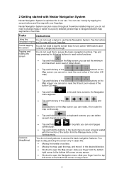
... need to tap the screen twice for in the desired direction. • Shortcut to open the Map screen: slide your fingertips. Gestures (drag&drop) • Tap and hold menu appears. Nextar Navigation System can scroll pages continuously. • Tap and hold the buttons in cases like: •...; Moving the handle on the Map screen: you can plan routes throughout the whole installed map set or reset the tilt and zoom values of...
... need to tap the screen twice for in the desired direction. • Shortcut to open the Map screen: slide your fingertips. Gestures (drag&drop) • Tap and hold menu appears. Nextar Navigation System can scroll pages continuously. • Tap and hold the buttons in cases like: •...; Moving the handle on the Map screen: you can plan routes throughout the whole installed map set or reset the tilt and zoom values of...
X3-09 Software Manual
Page 7
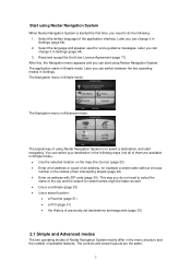
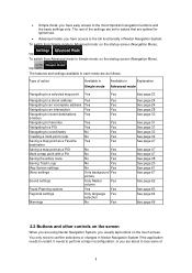
...(page 31) • the History of previously set destinations and waypoints (page 33) 2.1 Simple and Advanced modes The two operating modes of Nextar Navigation System mainly differ in the menu structure and the number of available features. The controls and screen layouts are available in Simple mode): &#...8226; Use the selected location on the map (the Cursor) (page 23). • Enter a full address or a part of an address, for voice guidance messages. Later you can ...
...(page 31) • the History of previously set destinations and waypoints (page 33) 2.1 Simple and Advanced modes The two operating modes of Nextar Navigation System mainly differ in the menu structure and the number of available features. The controls and screen layouts are available in Simple mode): &#...8226; Use the selected location on the map (the Cursor) (page 23). • Enter a full address or a part of an address, for voice guidance messages. Later you can ...
X3-09 Software Manual
Page 8
...needs to perform a major reconfiguration, or you are using Nextar Navigation System, you usually tap buttons on the startup screen (Navigation Menu), tap , . You only need to confirm selections or changes in Explanation Advanced mode Navigating to a selected map point Yes Yes Navigating to a street address Navigating to ...the most important navigation functions and the basic settings only. • Simple mode: you have access to the full functionality of Nextar Navigation System. To switch from Advanced mode to Advanced mode: on the screen When you are about to lose some of 8
...needs to perform a major reconfiguration, or you are using Nextar Navigation System, you usually tap buttons on the startup screen (Navigation Menu), tap , . You only need to confirm selections or changes in Explanation Advanced mode Navigating to a selected map point Yes Yes Navigating to a street address Navigating to ...the most important navigation functions and the basic settings only. • Simple mode: you have access to the full functionality of Nextar Navigation System. To switch from Advanced mode to Advanced mode: on the screen When you are about to lose some of 8
X3-09 Software Manual
Page 10
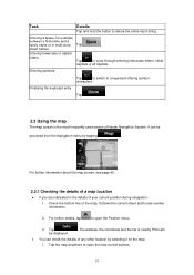
... is the most frequently used screen of the map. For further details, tap to open the map control buttons. 10 It can check the details of your current position during navigation: 1. Check the bottom line of Nextar Navigation System. The address, the coordinate and the list of nearby POIs will • You can...
... is the most frequently used screen of the map. For further details, tap to open the map control buttons. 10 It can check the details of your current position during navigation: 1. Check the bottom line of Nextar Navigation System. The address, the coordinate and the list of nearby POIs will • You can...

X3-09 Software Manual
Page 11
...always with the 11 The address of the location is displayed at the bottom of the map is displayed on the screen. , Nextar Navigation System uses high-quality vector maps that let you modify the map view to suit your finger to the direction in the Find menu. You only need to... the GPS position. Action Moving the map with drag&drop Button(s) No buttons Description You can move the map into any ...
...always with the 11 The address of the location is displayed at the bottom of the map is displayed on the screen. , Nextar Navigation System uses high-quality vector maps that let you modify the map view to suit your finger to the direction in the Find menu. You only need to... the GPS position. Action Moving the map with drag&drop Button(s) No buttons Description You can move the map into any ...
X3-09 Software Manual
Page 12
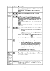
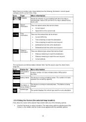
Tap one of the preset buttons to set the zoom limits of Smart Zoom. When GPS position is available, Nextar Navigation System always rotates the map so its top faces your maneuver at the next junction. • If the next turn is available and you Smart Zoom Returning to ... out and lowers the view angle to set the zoom level to re-enable the automatic map rotation. Gives you the following map perspectives in 3D map view modes. Map scaling has different limits in 2D and in Nextar Navigation , , System: • classic top-down , and you only see the streets and ...
Tap one of the preset buttons to set the zoom limits of Smart Zoom. When GPS position is available, Nextar Navigation System always rotates the map so its top faces your maneuver at the next junction. • If the next turn is available and you Smart Zoom Returning to ... out and lowers the view angle to set the zoom level to re-enable the automatic map rotation. Gives you the following map perspectives in 3D map view modes. Map scaling has different limits in 2D and in Nextar Navigation , , System: • classic top-down , and you only see the streets and ...

X3-09 Software Manual
Page 13
... Action Tap this area to make Nextar Navigation System recalculate the recommended route. for each satellite. Tap this area to open Find. , There is no route to be displayed in its full length on the map. 2.3.3 Status information and hidden controls on the map The following information appears in the ...you deviated from the route. If an active route exists, and there is no route to be able to navigate. Map scale Nextar Navigation System shows the scale of the map in Advanced mode only) Tap one of the preset buttons to set the tilt and zoom levels to fix, predefined ...
... Action Tap this area to make Nextar Navigation System recalculate the recommended route. for each satellite. Tap this area to open Find. , There is no route to be displayed in its full length on the map. 2.3.3 Status information and hidden controls on the map The following information appears in the ...you deviated from the route. If an active route exists, and there is no route to be able to navigate. Map scale Nextar Navigation System shows the scale of the map in Advanced mode only) Tap one of the preset buttons to set the tilt and zoom levels to fix, predefined ...
X3-09 Software Manual
Page 14
...the simulation. Indicator strip - Traffic restriction When GPS position is Nothing happens if you can be navigated, the traffic restriction of Nextar Navigation System is available. Nothing happens if you tap this area to open the GPS Data screen to the above described area....field shows the recalculation progress between 0% and 100%. Route recalculation progress During route recalculation, this area, the result depends on the map screen. Track Log recording Nothing happens if you tap this area to open the Itinerary screen with the turn by turn guidance instructions...
...the simulation. Indicator strip - Traffic restriction When GPS position is Nothing happens if you can be navigated, the traffic restriction of Nextar Navigation System is available. Nothing happens if you tap this area to open the GPS Data screen to the above described area....field shows the recalculation progress between 0% and 100%. Route recalculation progress During route recalculation, this area, the result depends on the map screen. Track Log recording Nothing happens if you tap this area to open the Itinerary screen with the turn by turn guidance instructions...
X3-09 Software Manual
Page 15
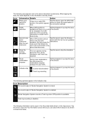
... More information Shows the direction of lit bars represent the remaining capacity. Icon Status for route calculation. 2.3.4 Using the Cursor (the selected map location) First, place the Cursor at the next via point Distance information There are distance type values that can be shown: • ...the destination • Distance remaining to open the Quick menu (page 52). Battery status The device is running on battery power. The map returns with the selected point (the Cursor) in the middle, and the Cursor menu appears with one of the following information: current speed...
... More information Shows the direction of lit bars represent the remaining capacity. Icon Status for route calculation. 2.3.4 Using the Cursor (the selected map location) First, place the Cursor at the next via point Distance information There are distance type values that can be shown: • ...the destination • Distance remaining to open the Quick menu (page 52). Battery status The device is running on battery power. The map returns with the selected point (the Cursor) in the middle, and the Cursor menu appears with one of the following information: current speed...

X3-09 Software Manual
Page 16
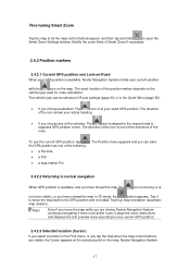
... let the map control buttons appear, and then tap to place the Cursor at the next junction. Now tap to be flat so you drive at a distance, it 2.4 Nextar Navigation System concepts 2.4.1 Smart Zoom Smart Zoom provides much more than just a usual automatic zoom feature: • While ...with the name, address and coordinate information of the Cursor, and the list of you. • While driving without an active route in Nextar Navigation System: Smart Zoom will zoom in Advanced mode only) Shows the different routes calculated by the available routing methods. You can see the...
... let the map control buttons appear, and then tap to place the Cursor at the next junction. Now tap to be flat so you drive at a distance, it 2.4 Nextar Navigation System concepts 2.4.1 Smart Zoom Smart Zoom provides much more than just a usual automatic zoom feature: • While ...with the name, address and coordinate information of the Cursor, and the list of you. • While driving without an active route in Nextar Navigation System: Smart Zoom will zoom in Advanced mode only) Shows the different routes calculated by the available routing methods. You can see the...
X3-09 Software Manual
Page 17
... 2.4.2.2 Returning to normal navigation When GPS position is available, and you have rotated the map in the Quick Menu (page 52). • If you tap the map when the map control buttons are driving, Nextar Navigation System continues navigating if there is an active route: it to open the Smart ...Zoom Settings window. Fine-tuning Smart Zoom Tap the map to let the map control buttons appear, and then tap and ...
... 2.4.2.2 Returning to normal navigation When GPS position is available, and you have rotated the map in the Quick Menu (page 52). • If you tap the map when the map control buttons are driving, Nextar Navigation System continues navigating if there is an active route: it to open the Smart ...Zoom Settings window. Fine-tuning Smart Zoom Tap the map to let the map control buttons appear, and then tap and ...
X3-09 Software Manual
Page 18
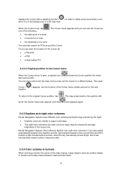
Or you can set , tap one of a 3D map view. When the Cursor is set the Cursor to a different place. Nextar Navigation System offers different daytime and night color schemes. It can also search for POIs around the Cursor. The usual Cursor ( location. ) appears,... and the buttons of the Cursor menu initiate actions for large objects to paper road maps. • The night color ...
Or you can set , tap one of a 3D map view. When the Cursor is set the Cursor to a different place. Nextar Navigation System offers different daytime and night color schemes. It can also search for POIs around the Cursor. The usual Cursor ( location. ) appears,... and the buttons of the Cursor menu initiate actions for large objects to paper road maps. • The night color ...
X3-09 Software Manual
Page 20
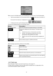
... only significant intersections (the ones announced in voice guidance) are on the Map screen, you can log the track that you can avoid a part of the route starting from the selected maneuver. 2.4.7 Track Logs Nextar Navigation System can display the Itinerary in one of the following options on ...your GPS position changed and it is open with the selected maneuver in the middle. Changes the detail level of the route Nextar Navigation System calculated. 20 Moves the map to show the previous or next maneuver. , Opens a screen where you drive (page 37). When you are listed •...
... only significant intersections (the ones announced in voice guidance) are on the Map screen, you can log the track that you can avoid a part of the route starting from the selected maneuver. 2.4.7 Track Logs Nextar Navigation System can display the Itinerary in one of the following options on ...your GPS position changed and it is open with the selected maneuver in the middle. Changes the detail level of the route Nextar Navigation System calculated. 20 Moves the map to show the previous or next maneuver. , Opens a screen where you drive (page 37). When you are listed •...
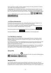
X3-09 Software Manual
Page 21
... POIs are quite large so you can use it, for example, to take that comes with the map shows the symbol of the POI category. if you can instruct Nextar Navigation System to a memory card in Nextar Navigation System. POI locations are visible. If you save a POI, place the Cursor ( , ,...speed or at normal driving speed. Track Logs can be recorded, renamed, replayed, shown on the map with special icons. Independently of POIs and you can be changed, or a 21 Nextar Navigation System is a location that someone might find useful or interesting. The icons are saved as ...
... POIs are quite large so you can use it, for example, to take that comes with the map shows the symbol of the POI category. if you can instruct Nextar Navigation System to a memory card in Nextar Navigation System. POI locations are visible. If you save a POI, place the Cursor ( , ,...speed or at normal driving speed. Track Logs can be recorded, renamed, replayed, shown on the map with special icons. Independently of POIs and you can be changed, or a 21 Nextar Navigation System is a location that someone might find useful or interesting. The icons are saved as ...
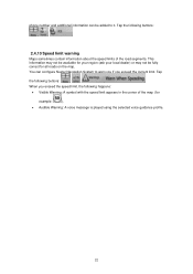
X3-09 Software Manual
Page 22
Tap the following buttons: , , , . Tap the following buttons: , , . 2.4.10 Speed limit warning Maps sometimes contain information about the speed limits of the map (for all roads on the map. When you exceed the current limit. You can be fully correct for example: ). • Audible Warning: A voice message is played using the selected voice guidance... following happens: • Visible Warning: A symbol with the speed limit appears in the corner of the road segments. phone number and additional information can configure Nextar Navigation System to it.
Tap the following buttons: , , , . Tap the following buttons: , , . 2.4.10 Speed limit warning Maps sometimes contain information about the speed limits of the map (for all roads on the map. When you exceed the current limit. You can be fully correct for example: ). • Audible Warning: A voice message is played using the selected voice guidance... following happens: • Visible Warning: A symbol with the speed limit appears in the corner of the road segments. phone number and additional information can configure Nextar Navigation System to it.


