Manual - English
Page 6
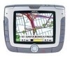
... Support ...1 Warranty Service ...1 Customer Service ...1 Registration ...1 Chapter 2: GPS Information ...2 About Satellite Navigation ...2 How Satellite Navigation Works ...2 Line of Sight ...2 A Word on the Safe Usage of GPS Maps ...3 From Source to Destination...3 Placement of Your GPS Receiver for Optimal Satellite Reception ...3 Signal Acquisition Time ...3 GPS Maps and Your Safety ...4 Chapter 3: Magellan RoadMate 6000T ...5 Front View ...5 Rear View ...6 Top View ...6 Bottom View...
... Support ...1 Warranty Service ...1 Customer Service ...1 Registration ...1 Chapter 2: GPS Information ...2 About Satellite Navigation ...2 How Satellite Navigation Works ...2 Line of Sight ...2 A Word on the Safe Usage of GPS Maps ...3 From Source to Destination...3 Placement of Your GPS Receiver for Optimal Satellite Reception ...3 Signal Acquisition Time ...3 GPS Maps and Your Safety ...4 Chapter 3: Magellan RoadMate 6000T ...5 Front View ...5 Rear View ...6 Top View ...6 Bottom View...
Manual - English
Page 8
...Destination ...51 Search by City...51 Search by Zip Code ...52 Search by State...52 Previous City...53 Chapter 8: Navigation Options ...55 Configuration ...55 POI Selection...55 Custom POIs ...55 Map Options ...60 TrueView Options ...60 Select Map Color......60 Route Preferences...61 Detour Options...62 Menu Colors...63 Tone Options...63 GPS Options...63 GPS Status ...63 Set GPS Position ...64 Simulator Mode...64 Automatic Volume...65 Backup and Restore...65 Backup ...65 Restore ...65... wireless technology ...84 iii Then you input the passkey in your Magellan RoadMate.
...Destination ...51 Search by City...51 Search by Zip Code ...52 Search by State...52 Previous City...53 Chapter 8: Navigation Options ...55 Configuration ...55 POI Selection...55 Custom POIs ...55 Map Options ...60 TrueView Options ...60 Select Map Color......60 Route Preferences...61 Detour Options...62 Menu Colors...63 Tone Options...63 GPS Options...63 GPS Status ...63 Set GPS Position ...64 Simulator Mode...64 Automatic Volume...65 Backup and Restore...65 Backup ...65 Restore ...65... wireless technology ...84 iii Then you input the passkey in your Magellan RoadMate.
Manual - English
Page 12
... This second phase is already well underway. Global Positioning System (GPS) and the Russian GLObal NAvigation Satellite System (GLONASS). A fourth satellite must be in "view" of a receiver in order to calculate longitude and latitude. GNSS-2 requires the ...recreational and industrial activities. 2.2.1 Line of Sight Satellite-navigation receivers operate by two sets of navigation, sports, and recreational activities. Navigation satellite receivers use of additional augmentation systems. While the GPS and GLONASS satellite networks are continuously within line of ground...
... This second phase is already well underway. Global Positioning System (GPS) and the Russian GLObal NAvigation Satellite System (GLONASS). A fourth satellite must be in "view" of a receiver in order to calculate longitude and latitude. GNSS-2 requires the ...recreational and industrial activities. 2.2.1 Line of Sight Satellite-navigation receivers operate by two sets of navigation, sports, and recreational activities. Navigation satellite receivers use of additional augmentation systems. While the GPS and GLONASS satellite networks are continuously within line of ground...

Manual - English
Page 13
...The windshield mount included in the box allows you to place the receiver in your explorations and to use your Magellan RoadMate 6000T, or if you use common sense. 2.3.1 From Source to Destination Thales Navigation, maker of Magellan GPS products, is important to have your vehicle where it may be ...the products we test the compatibility of the map with it in receiving the initial satellite fix; Although weather conditions do not contain marine navigational markers. Chapter 2: GPS Information 2.3 A Word on the Safe Usage of GPS Maps Just like paper maps, maps on the source data used...
...The windshield mount included in the box allows you to place the receiver in your explorations and to use your Magellan RoadMate 6000T, or if you use common sense. 2.3.1 From Source to Destination Thales Navigation, maker of Magellan GPS products, is important to have your vehicle where it may be ...the products we test the compatibility of the map with it in receiving the initial satellite fix; Although weather conditions do not contain marine navigational markers. Chapter 2: GPS Information 2.3 A Word on the Safe Usage of GPS Maps Just like paper maps, maps on the source data used...
Manual - English
Page 14
... change or may not always reflect the complete picture. For instance, the Magellan RoadMate 6000T GPS receiver should be used with common sense, and it is an aid to navigation. neighborhood quality or safety; road slope or grade; pavement characteristics or conditions; When using GPS, you must be used while engaged in any activity requiring the user...
... change or may not always reflect the complete picture. For instance, the Magellan RoadMate 6000T GPS receiver should be used with common sense, and it is an aid to navigation. neighborhood quality or safety; road slope or grade; pavement characteristics or conditions; When using GPS, you must be used while engaged in any activity requiring the user...
Manual - English
Page 75
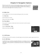
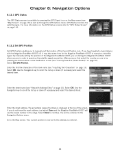
... to let you know to "GPS Status Screen" on the GPS Status screens refer to make the maneuver. Select either Bell, Chime, or Beep. Chapter 8: Navigation Options When you encounter traffic, and the set time has elapsed again when it will flash on the screen to have the Magellan RoadMate 6000T calculate the detour. Select Tone...
... to let you know to "GPS Status Screen" on the GPS Status screens refer to make the maneuver. Select either Bell, Chime, or Beep. Chapter 8: Navigation Options When you encounter traffic, and the set time has elapsed again when it will flash on the screen to have the Magellan RoadMate 6000T calculate the detour. Select Tone...
Manual - English
Page 76
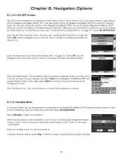
... the Globe button on the Destination screen (see "Help with the Magellan RoadMate 6000T off the Simulator will "drive" at two times normal speed. Chapter 8: Navigation Options 8.1.10.2 Set GPS Position Set GPS Position enables you to manually set to the address you entered. ...8.1.11 Simulator Mode In Simulator Mode, you can demonstrate the capabilities of the Magellan RoadMate 6000T without actually driving. To disable Simulator...
... the Globe button on the Destination screen (see "Help with the Magellan RoadMate 6000T off the Simulator will "drive" at two times normal speed. Chapter 8: Navigation Options 8.1.10.2 Set GPS Position Set GPS Position enables you to manually set to the address you entered. ...8.1.11 Simulator Mode In Simulator Mode, you can demonstrate the capabilities of the Magellan RoadMate 6000T without actually driving. To disable Simulator...
Manual - UK English
Page 6
... Support ...1 Warranty Service ...1 Customer Service ...1 Registration ...1 Chapter 2: GPS Information ...2 About Satellite Navigation ...2 How Satellite Navigation Works ...2 Line of Sight ...2 A Word on the Safe Usage of GPS Maps ...3 From Source to Destination...3 Placement of Your GPS Receiver for Optimal Satellite Reception ...3 Signal Acquisition Time ...3 GPS Maps and Your Safety ...4 Chapter 3: Magellan RoadMate 6000T ...5 Front View ...5 Rear View ...6 Top View ...6 Bottom View...
... Support ...1 Warranty Service ...1 Customer Service ...1 Registration ...1 Chapter 2: GPS Information ...2 About Satellite Navigation ...2 How Satellite Navigation Works ...2 Line of Sight ...2 A Word on the Safe Usage of GPS Maps ...3 From Source to Destination...3 Placement of Your GPS Receiver for Optimal Satellite Reception ...3 Signal Acquisition Time ...3 GPS Maps and Your Safety ...4 Chapter 3: Magellan RoadMate 6000T ...5 Front View ...5 Rear View ...6 Top View ...6 Bottom View...

Manual - UK English
Page 7
... a Junction as a Destination ...52 Search by Town...52 Search by Postcode...53 Search by County / Area...53 Previous Town...54 Chapter 8: Navigation Options ...56 Trip Computer ...56 Current Trip ...56 POI Selection ...58 Custom POIs ...59 Map Options ...64 TrueView Options ...64 Select Map... ...65 Detour Options ...66 Voice Options ...67 Menu Colours ...67 Tone Options ...67 GPS Options ...67 GPS Status...68 Set GPS Position ...68 Simulator Mode ...69 Automatic Volume ...69 TMC Options ...69 Navigation Instruction ...69 Backup and Restore ...69 Backup ...70 Restore ...70 Clear Address Book ......
... a Junction as a Destination ...52 Search by Town...52 Search by Postcode...53 Search by County / Area...53 Previous Town...54 Chapter 8: Navigation Options ...56 Trip Computer ...56 Current Trip ...56 POI Selection ...58 Custom POIs ...59 Map Options ...64 TrueView Options ...64 Select Map... ...65 Detour Options ...66 Voice Options ...67 Menu Colours ...67 Tone Options ...67 GPS Options ...67 GPS Status...68 Set GPS Position ...68 Simulator Mode ...69 Automatic Volume ...69 TMC Options ...69 Navigation Instruction ...69 Backup and Restore ...69 Backup ...70 Restore ...70 Clear Address Book ......
Manual - UK English
Page 11
... are being developed to at least three satellites must also be within line of sight of industries. Navigation satellite receivers use of additional augmentation systems. While the GPS and GLONASS satellite networks are continuously within line of navigation, sports, and recreational activities. By comparing the time the signals were transmitted from three or more...
... are being developed to at least three satellites must also be within line of sight of industries. Navigation satellite receivers use of additional augmentation systems. While the GPS and GLONASS satellite networks are continuously within line of navigation, sports, and recreational activities. By comparing the time the signals were transmitted from three or more...
Manual - UK English
Page 12
... sources are available but still may take 15 minutes or more detailed the map. Thales Navigation licenses* topographical maps, roadmaps, marine charts and points of interest (POI) data from commercial... area of your Magellan RoadMate 6000T, or if you travel over 500 miles with paper maps) it is important to consider what type of map you are using GPS maps (just as... fix times and greater signal strength. External conditions also affect GPS signal reception. The GPS receiver constantly monitors and updates the GPS signal status and will often present only a minimal representation of...
... sources are available but still may take 15 minutes or more detailed the map. Thales Navigation licenses* topographical maps, roadmaps, marine charts and points of interest (POI) data from commercial... area of your Magellan RoadMate 6000T, or if you travel over 500 miles with paper maps) it is important to consider what type of map you are using GPS maps (just as... fix times and greater signal strength. External conditions also affect GPS signal reception. The GPS receiver constantly monitors and updates the GPS signal status and will often present only a minimal representation of...
Manual - UK English
Page 13
... and speed restrictions); neighbourhood quality or safety; weather conditions; Thales Navigation also licenses map data from governmental sources such as, but not limited to view the display while driving. For instance, the Magellan RoadMate 6000T GPS receiver should be impassable, trees and tall buildings can obscure GPS signals, and your primary concern. road slope or grade; population...
... and speed restrictions); neighbourhood quality or safety; weather conditions; Thales Navigation also licenses map data from governmental sources such as, but not limited to view the display while driving. For instance, the Magellan RoadMate 6000T GPS receiver should be impassable, trees and tall buildings can obscure GPS signals, and your primary concern. road slope or grade; population...
Manual - UK English
Page 76
Chapter 8: Navigation Options When you to select a male or female voice. and after one of four colour schemes. When you have finished, select Save. 8.12 GPS Options GPS Options provide you know to ignore the Detour alert; Select a male or female voice and then select Save. 8.10 Menu Colours You can choose to .... 8.9 Voice Options Voice options allows you encounter traffic, and the set time has elapsed, the Detour icon will flash on the screen to allow the Magellan RoadMate 6000T to speed up signal acquisition time. 67 Touch the icon on the Map screen. Select Tone Options.
Chapter 8: Navigation Options When you to select a male or female voice. and after one of four colour schemes. When you have finished, select Save. 8.12 GPS Options GPS Options provide you know to ignore the Detour alert; Select a male or female voice and then select Save. 8.10 Menu Colours You can choose to .... 8.9 Voice Options Voice options allows you encounter traffic, and the set time has elapsed, the Detour icon will flash on the screen to allow the Magellan RoadMate 6000T to speed up signal acquisition time. 67 Touch the icon on the Map screen. Select Tone Options.
Manual - UK English
Page 77
... is now set the location of the screen. For more information on the GPS Status screens refer to "GPS Status Screen" on the Map screen (see "Help with the Magellan RoadMate 6000T off, it may take some time for the Magellan RoadMate 6000T to the Navigation Options menu. Enter the street name (see "Map Screen" on page 15). If...
... is now set the location of the screen. For more information on the GPS Status screens refer to "GPS Status Screen" on the Map screen (see "Help with the Magellan RoadMate 6000T off, it may take some time for the Magellan RoadMate 6000T to the Navigation Options menu. Enter the street name (see "Map Screen" on page 15). If...
Manual - UK English
Page 79
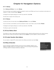
...and Restore, then select Restore. Insert a card and reselect Restore. Select Yes. Make your selection. If you a way to confirm your Magellan RoadMate 6000T. The files are copied to the hard disk. 8.18 Clear Address Book This offers you do not have . 70 The files will be ...card. 8.17.2 Restore To restore the files to confirm the deletion. 8.19 Context Sensitive Help Options You can enable or disable GPS context sensitive help. Chapter 8: Navigation Options 8.17.1 Backup Select Backup and Restore, then select Backup. A dialogue box will appear asking you will be prompted to ...
...and Restore, then select Restore. Insert a card and reselect Restore. Select Yes. Make your selection. If you a way to confirm your Magellan RoadMate 6000T. The files are copied to the hard disk. 8.18 Clear Address Book This offers you do not have . 70 The files will be ...card. 8.17.2 Restore To restore the files to confirm the deletion. 8.19 Context Sensitive Help Options You can enable or disable GPS context sensitive help. Chapter 8: Navigation Options 8.17.1 Backup Select Backup and Restore, then select Backup. A dialogue box will appear asking you will be prompted to ...


