Manual - English
Page 2
... is less than 32°F (0°C) or more than 113°F (45°C) 1 road slope or grade; special events; However, roadways, points of law enforcement, emergency rescue, medical, or other assistance; bridge height, width, weight, or other mount or accessories, that it exposed to extreme... to yourself or others: • California law prohibits mounting any of car charger will result in malfunction and/or danger. • The Magellan RoadMate 3000T is intended to be removed. Use of another type of the following: legal restrictions (such as vehicular type, weight, height, width,...
... is less than 32°F (0°C) or more than 113°F (45°C) 1 road slope or grade; special events; However, roadways, points of law enforcement, emergency rescue, medical, or other assistance; bridge height, width, weight, or other mount or accessories, that it exposed to extreme... to yourself or others: • California law prohibits mounting any of car charger will result in malfunction and/or danger. • The Magellan RoadMate 3000T is intended to be removed. Use of another type of the following: legal restrictions (such as vehicular type, weight, height, width,...
Manual - English
Page 6
... Search by State ...37 Previous City ...38 Trip Planner ...39 New ...39 Optimizing a Trip ...41 Guide Me ...42 Edit ...42 Delete and Rename ...43 Selecting a Point of Interest as a Destination ...45 Spell Name ...46 Nearest ...46 List By City ...46 Select Category ...47 Select Category...47 Nearest ...48 List by City...
... Search by State ...37 Previous City ...38 Trip Planner ...39 New ...39 Optimizing a Trip ...41 Guide Me ...42 Edit ...42 Delete and Rename ...43 Selecting a Point of Interest as a Destination ...45 Spell Name ...46 Nearest ...46 List By City ...46 Select Category ...47 Select Category...47 Nearest ...48 List by City...
Manual - English
Page 10
...GPS and GLONASS transmissions with global-positioning satellites. By comparing the time the signals were transmitted from three or more satellites reveals its position as longitude/latitude, Universal Transverse Mercator (UTM), Military Grid (MG), or simply as a point on the surface of sight to provide improved accuracy. The distance of the receiving... device. Navigation satellite receivers use of navigation satellites will pass through triangulation....
...GPS and GLONASS transmissions with global-positioning satellites. By comparing the time the signals were transmitted from three or more satellites reveals its position as longitude/latitude, Universal Transverse Mercator (UTM), Military Grid (MG), or simply as a point on the surface of sight to provide improved accuracy. The distance of the receiving... device. Navigation satellite receivers use of navigation satellites will pass through triangulation....
Manual - English
Page 11
... paper maps) it is important to ensure that your GPS receiver is important to consider what type of our maps on our GPS devices. Topographic maps usually provide minimal detail about bodies of your Magellan RoadMate 3000T, or if you to reflect these changes. We...changes frequently due to provide a better user experience for a specific purpose. Thales Navigation licenses* topographical maps, roadmaps, marine charts and points of the vehicle. And to strike other items, or where vibration may require an external antenna. Whether topographical maps, roadmaps or ...
... paper maps) it is important to ensure that your GPS receiver is important to consider what type of our maps on our GPS devices. Topographic maps usually provide minimal detail about bodies of your Magellan RoadMate 3000T, or if you to reflect these changes. We...changes frequently due to provide a better user experience for a specific purpose. Thales Navigation licenses* topographical maps, roadmaps, marine charts and points of the vehicle. And to strike other items, or where vibration may require an external antenna. Whether topographical maps, roadmaps or ...
Manual - English
Page 25
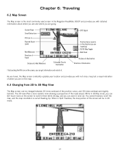
GPS Signal Position Cursor (points in and out. The 3D view offers a more realistic view showing a perspective of where you are on the screen to route to them while driving, ... Map Toggle Next Road Distance to Destination † By touching the POI icon on the screen, you are and where you can be in the Magellan RoadMate 3000T and provides you with not only a map but a visual indication of the roads ahead. Chapter 6: Traveling 6.2 Map Screen The Map screen is set at...
GPS Signal Position Cursor (points in and out. The 3D view offers a more realistic view showing a perspective of where you are on the screen to route to them while driving, ... Map Toggle Next Road Distance to Destination † By touching the POI icon on the screen, you are and where you can be in the Magellan RoadMate 3000T and provides you with not only a map but a visual indication of the roads ahead. Chapter 6: Traveling 6.2 Map Screen The Map screen is set at...
Manual - English
Page 30
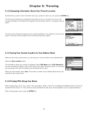
...the map, and the distance from and the last street you passed. 6.13 Saving Your Current Location to the location and other POI, the Magellan RoadMate 3000T can press the LOCATE key. The first screen displays your Address Book. Select Edit Name and/or Edit Information and use the keypad to... assign a name to Your Address Book While you have finished, select Save. Select the Save Location button. If the point you are in , the latitude and longitude of your present location, a compass, and your location is off-road, the nearest road information will be...
...the map, and the distance from and the last street you passed. 6.13 Saving Your Current Location to the location and other POI, the Magellan RoadMate 3000T can press the LOCATE key. The first screen displays your Address Book. Select Edit Name and/or Edit Information and use the keypad to... assign a name to Your Address Book While you have finished, select Save. Select the Save Location button. If the point you are in , the latitude and longitude of your present location, a compass, and your location is off-road, the nearest road information will be...
Manual - English
Page 33
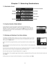
...name (see "Help with Address Entry" on page 13). The acceptable range of street numbers is the first time using this point you can choose to edit the information or, if you select the country where your Home button. The Home button allows ... screen. 7.3 Entering and Routing to Your Home Address The Magellan RoadMate 3000T enables you route to most often. Chapter 7: Selecting Destinations 7.1 Destination Screen Current Country for Destination Map Button Select Address Home Button Address Book Points of Interest Globe Button Intersection 7.2 Country Selection (Globe Button)...
...name (see "Help with Address Entry" on page 13). The acceptable range of street numbers is the first time using this point you can choose to edit the information or, if you select the country where your Home button. The Home button allows ... screen. 7.3 Entering and Routing to Your Home Address The Magellan RoadMate 3000T enables you route to most often. Chapter 7: Selecting Destinations 7.1 Destination Screen Current Country for Destination Map Button Select Address Home Button Address Book Points of Interest Globe Button Intersection 7.2 Country Selection (Globe Button)...

Manual - English
Page 48
... method for the new trip and select OK. Select Address will add a destination from a previous destination, Address Book, or favorites; will add a destination by selecting a point on the map; Continue adding destinations.
... method for the new trip and select OK. Select Address will add a destination from a previous destination, Address Book, or favorites; will add a destination by selecting a point on the map; Continue adding destinations.

Manual - English
Page 53
... the POI database (accessed through the Dining, ATM, Gas... page 49 Points of popular destinations without having to enter the address manually in the database, which range from restaurants, parks, gas stations, and banks, to schools ... select OK. The purpose of Interest as a Destination Spell Name - Chapter 7: Selecting Destinations Use the backspace key to them. 45 There are preloaded into the Magellan RoadMate 3000T database. Custom POIs - When you with a list of Interest (or POIs) are commercial or recreational locations, landmarks, or services that are over six million...
... the POI database (accessed through the Dining, ATM, Gas... page 49 Points of popular destinations without having to enter the address manually in the database, which range from restaurants, parks, gas stations, and banks, to schools ... select OK. The purpose of Interest as a Destination Spell Name - Chapter 7: Selecting Destinations Use the backspace key to them. 45 There are preloaded into the Magellan RoadMate 3000T database. Custom POIs - When you with a list of Interest (or POIs) are commercial or recreational locations, landmarks, or services that are over six million...

Manual - English
Page 64
... the Map screen. Select Mark All to set . Select Alert Parameters. 56 Select Display Categories. Select Set Alarms. Again, you can now choose at what point you will be alerted when you wish not to have any alerts set . Select Clear All if you approach a custom POI. Select Clear All if...
... the Map screen. Select Mark All to set . Select Alert Parameters. 56 Select Display Categories. Select Set Alarms. Again, you can now choose at what point you will be alerted when you wish not to have any alerts set . Select Clear All if you approach a custom POI. Select Clear All if...
Manual - English
Page 92
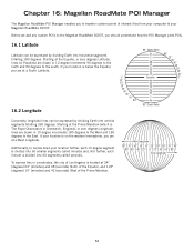
...10-degree increments 180 degrees to the West and 180 degrees to the East. Chapter 16: Magellan RoadMate POI Manager The Magellan RoadMate POI Manager enables you to transfer custom points of interest files from your computer to your location further, each 10-degree segment is divided ...° 80° East Longitude 84 Starting at the Prime Meridian (which is located at a West Longitude. Additionally, to the Magellan RoadMate 3000T, you should understand how the POI Manager plots POIs. 16.1 Latitude Latitude can be expressed by dividing Earth into vertical segments totalling...
...10-degree increments 180 degrees to the West and 180 degrees to the East. Chapter 16: Magellan RoadMate POI Manager The Magellan RoadMate POI Manager enables you to transfer custom points of interest files from your computer to your location further, each 10-degree segment is divided ...° 80° East Longitude 84 Starting at the Prime Meridian (which is located at a West Longitude. Additionally, to the Magellan RoadMate 3000T, you should understand how the POI Manager plots POIs. 16.1 Latitude Latitude can be expressed by dividing Earth into vertical segments totalling...
Manual - English
Page 93
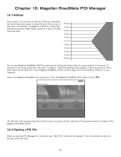
...and the right side of the window shows the contents of the Magellan RoadMate 3000T. 16.4 Opening a POI File When you start the POI Manager the contents of the ocean, or Sea Level. Altitude is expressed by how far the point is the default location for approximately 2-3 seconds, 10 seconds if... not in sleep mode (see "Top View" on POI. Chapter 16: Magellan RoadMate POI Manager 16.3 Altitude Each location can also have an Altitude.
...and the right side of the window shows the contents of the Magellan RoadMate 3000T. 16.4 Opening a POI File When you start the POI Manager the contents of the ocean, or Sea Level. Altitude is expressed by how far the point is the default location for approximately 2-3 seconds, 10 seconds if... not in sleep mode (see "Top View" on POI. Chapter 16: Magellan RoadMate POI Manager 16.3 Altitude Each location can also have an Altitude.

