Magellan RoadMate 1200 Support Question
Magellan RoadMate 1200 Support Question
Find answers below for this question about Magellan RoadMate 1200 - Automotive GPS Receiver.Need a Magellan RoadMate 1200 manual? We have 12 online manuals for this item!
Question posted by sasa64068 on July 23rd, 2014
Points of interest
Does this unit include updated POI'S
Current Answers
Related Magellan RoadMate 1200 Manual Pages
Triton User Manual Addendum - English, French, Spanish - Page 1

... System for the perimeter and area. Triton User Manual Addendum
This addendum applies to Triton GPS receivers that have a software version that you are done. Select "Pause Track Record". Pressing ENTER...end points of the screen. This will be presented with many more options then were previously available. In this software update you are then computed and displayed at point A ...
Triton User Manual Addendum - English, French, Spanish - Page 2

...any navigational screen. User Defined Map Datum. (Advanced Users) You can now select which point in this case (C). Set the coordinates or select the position from the contextual menu. ...map. Set Custom Position. To turn the feature off and resume computing GPS position information, go there instead of the receiver is disabled and the screen is activated it to go to a previous ...
Manual - English - Page 2
...dangerous and can be affected by the periodic adjustments to GPS satellites made by the U.S.
Government, which you in...of this guide may severely degrade performance or damage the receiver, and will void the warranty. the use without the... may be affected by any means, electronic or mechanical, including photocopying and recording, for navigating.
Accuracy can result in ...
Manual - English - Page 7
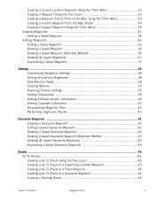
Creating a Current Location Waypoint Using the Triton Menu 33 Creating a Waypoint Using the Pan Cursor 33 Creating a Waypoint from a Point on the Map Using the Triton Menu 34 Creating a Custom Waypoint from the Map Screen 34 Creating a Custom Waypoint Using the Triton Menu 35 Viewing ...
Manual - English - Page 9

..., and no matter how you hold the receiver. (GPS receivers without an electronic compass require that can be kept informed of possible software updates and new features as feature-packed National Geographic maps from an SD card that you for your point of the Magellan Triton GPS receiver. A built-in Europe may have local area base maps...
Manual - English - Page 11

... included) Up to 5 meters (10 - 16 feet) - Specifications PHYSICAL
Case Base Map
Size Weight Display Data Storage Antenna Keypad Operating Range
Rubber armored impact-resistant plastic, water-resistant seal, IPX-7 Built-in multidirectional patch Nine direct-access keys 14° to 140°F (-10° to 60°C)
PERFORMANCE
Receiver Acquisition Time Update...
Manual - English - Page 12
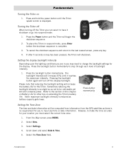
... in this chapter on Battery Life for other tips on
1. Note: maximum backlight intensity is reduced as not to be computed from information from the GPS satellites so there is so slight so as battery capacity gets lower. Select the Time Zone field. Press the backlight button momentarily.
Sometimes reducing the...
Manual - English - Page 14

... Menus
Accessing the features of these are used to your present location, by selecting a point on the map or by the Magellan Triton. The Main Menu has three options; Selecting ... create waypoints and multileg routes that the Triton will be available in a future update.
Scroll down and select Power Options.
5. Choose the interval that can be saved by entering the coordinates for...
Manual - English - Page 15

... The Media option contains the functions for information on the map or by selecting a point on updates to your current journey.
The Trips option will be available in the Magellan Triton. ...The Trail option provides a way for many of the support functions and tools found in a future update. The View Menu has options for you to save your current track (a record of your travels...
Manual - English - Page 17
...the backlight intensities.
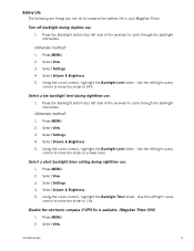
(Alternate method)
1. Select View. 3. Use the left side of the receiver) to conserve the battery life in your Magellan Triton. Use the left /right cursor
control ...to OFF. Press MENU. 2. Select Settings. 4. Select Settings. 4.
Disable the electronic compass if GPS fix is available. (Magellan Triton 500)
1. Battery Life
The following are things you can do to...
Manual - English - Page 24
... the bottom of the screen as colored bars. Signal levels are getting strong, weak, or poor signal reception.
Navigation Screens
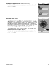
16 The numbers indicate the GPS satellite ID while "W" indicates WAAS (Wide Area Augmentation System) satellites. The Altimeter / Barometer Screen (Magellan Triton 500)
The Altimeter / Barometer screen displays your location. This...
Manual - English - Page 25

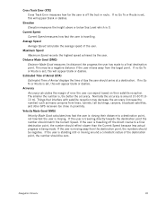
... Route is the measurement of distance from the user, measured in degrees relative to the final destination point in a route.
Destination
Destination measures the number of degrees a user must turn to match their ... L/R (Left or Right) and is in relation to arrive at one destination point, the unit should switch its guidance to 90° N/S (the Poles)
Longitude (LON)
Longitude is the coordinate...
Manual - English - Page 26
... standing still or moving away from trees, tunnels, tall buildings, canyons, broadcast satellites, and other GPS receivers too close in distance) the progress the user has made . If the user is being made to a final destination point, the number should match the Current Speed. If no Go To or Route is travelling off...
Manual - English - Page 27

... menu that has been saved in the receiver.)
Start Flag (Indicates the starting point of the active route.)
End Flag (Indicates the ending point of the active route.)
Waypoint (Indicates the...Map Screen Overview
Battery Level
Time of Day
GPS Signal Strength
North Indicator
Data Fields
Map Scale
Pan Mode
Map Legend
Present Position Cursor (Points in the direction of travel .)
Trail ...
Manual - English - Page 30

...is a waypoint, the icon in the upper left corner changes to change the page for that point described later.)
2. Press ESC to select Go To.
4.
Select the waypoint you want to ... information icon which offers additional functions for the waypoint details.
6. Viewing Waypoint Details from Point on the Info page and press ENTER or press ESC to exit the Waypoint Information screen...
Manual - English - Page 37
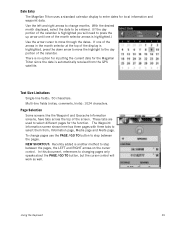
...The Waypoint Information screen shown here has three pages with three tabs to select them from the GPS satellite. NEW SHORTCUT: Recently added is another method to step between the pages. In this document... uses a standard calendar display to enter dates for the Magellan Triton since the date is automatically received from ; Use the left and right arrows to change pages use the PAGE / GO TO ...
Manual - English - Page 39
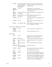
...BAROMETER
On, Off On, Off
Turns the electronic compass on the Map screen. Alarms Page
GPS FIX
On, Off
ALARM TONE
ALARM VOLUME
BEEPER VOLUME
Beep, Ring
Off, Low, Medium... displayed on or off .
Profiles
31 QUICK INFO
POSITION DESTINATION LINE WAYPOINTS SHOWN GEOCACHES SHOWN POIs SHOWN
TRACK LINES
MAP DETAIL
Off, Distance/Bearing Sets the information displayed in the
Direction, ...
Manual - English - Page 50

...user-created waypoint.
Select Geocache.
4. Geocache information includes Difficulty (1 through 5 with 5 being the most difficult), Terrain (1 though 5 with GPS users. They post these geocache waypoints into your... Geocaching.com can be found on or off.
9.
Select from Current Location, Point on geocaching web sites that you would probably select Current Location or Coordinates.)
5....
Manual - English - Page 55
... and stored in the action header bar.
11. Activating a Multileg Route
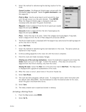
1. Routes
47 Point on the point desired. Select a waypoint from the list of the route.
10. Deleting one of saved... route leg destinations: Select the destination waypoint and choose the delete (trash can) icon to Add Point. Geocache: Select a waypoint from the route.)
Viewing the route: Select the View icon in the...
Manual - English - Page 61
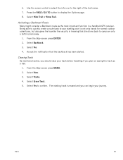
.... 2.
Select Yes. 4. Use the cursor control to select the info icon to your starting point is erased and you can begin your track before travelling if you should clear your journey.
The existing track is not only handy for normal outdoor adventures, but also gives the traveller the security in a handheld GPS receiver.
Similar Questions

I Found A Magellan Roadmate 1200. Is It Possible To View Maps W/o An Sd Card?
I found a Magellan RoadMate 1200. Is it possible to view maps w/o an SD card?
I found a Magellan RoadMate 1200. Is it possible to view maps w/o an SD card?
(Posted by horseflybite9 1 year ago)

My Magellan Roadmate 1200 Is Stuck In Warning Page Hire Do I Get It Unstuck
can you my magellan roadmate 1200 unstuck
can you my magellan roadmate 1200 unstuck
(Posted by laura1972lm 8 years ago)

How To Update Magellan Roadmate 1200 For Free
(Posted by mayrcyn 10 years ago)

Unlock Magellan Roadmate 1200
How do I unlock my Magellan Roadmate 1200
How do I unlock my Magellan Roadmate 1200
(Posted by sentahinzman 11 years ago)

Force Roadmate 1424 To Redo Recent Update Which Failed
Most recent Oct 1. update on my roadmate 1424 failed. Unit frozen in power up screen. error file...
Most recent Oct 1. update on my roadmate 1424 failed. Unit frozen in power up screen. error file...
(Posted by aa1420 13 years ago)