Magellan RoadMate 1200 Support Question
Magellan RoadMate 1200 Support Question
Find answers below for this question about Magellan RoadMate 1200 - Automotive GPS Receiver.Need a Magellan RoadMate 1200 manual? We have 12 online manuals for this item!
Question posted by mayrcyn on November 4th, 2013
How To Update Magellan Roadmate 1200 For Free
The person who posted this question about this Magellan product did not include a detailed explanation. Please use the "Request More Information" button to the right if more details would help you to answer this question.
Current Answers
Answer #1: Posted by bengirlxD on November 4th, 2013 3:17 PM
bengirlxD

Member since:
November 5th, 2012 Points: 6,395,085

Member since:
November 5th, 2012 Points: 6,395,085
You can update your device(Roadmate 1200) through Magellans website on the page here.
Feel free to resubmit the question if you didn't find it useful.
Related Magellan RoadMate 1200 Manual Pages
Triton User Manual Addendum - English, French, Spanish - Page 1

... Triton will be presented with the option of your track. Triton User Manual Addendum
This addendum applies to Triton GPS receivers that have a software version that you can now access the Main Menu on any navigational screen press ENTER. ...the track was started at the top of the track.
In this software update you are ready to save the track to or higher then the ones listed.
Triton User Manual Addendum - English, French, Spanish - Page 2

...in this example you are already close to waypoint D and wish to go there instead of the receiver is disabled and the screen is activated it to go to the next destination (D). But in the ..., press MENU from any navigational screen. Press ENTER. To turn the feature off and resume computing GPS position information, go to the location you will be presented with User Grid set as the map ...
Triton User Manual Addendum - English, French, Spanish - Page 8

All other trademarks and registered trademarks are registered trademarks of their respective owners.
604-0268-001 A All rights reserved. The Magellan logo, Magellan, and Triton are property of MiTAC International Corporation. ©2009 MiTAC International Corporation.
Manual - English - Page 2
..., like buildings and large trees. The accuracy of the GPS network. the use without the prior written permission of MiTAC Digital Corporation.
i No part of this guide may severely degrade performance or damage the receiver, and will void the warranty. When using the Magellan Triton, these safety rules must be followed to assist...
Manual - English - Page 3
.... This device complies with Part 15 of the Canadian Interference-Causing Equipment Regulations. The Magellan Triton must accept any other aerial or transmitter. This equipment generates, uses and can be used in conjunction with any interference received, including interference that changes and modifications made to the equipment without the approval of manufacturer...
Manual - English - Page 4
...;C.
© 2009 MiTAC International Corporation. End users must follow the specific operating instructions for product updates and additional information. This device may cause undesired operation of MiTAC International Corporation. 604-0264-001 A
iii Check the Magellan website (www.magellanGPS.com) for satisfying RF exposure compliance.
The information provided in conjunction with...
Manual - English - Page 9

...GPS fix, and no matter how you hold the receiver. (GPS receivers without an electronic compass require that can be kept informed of changing weather conditions.
Routes and tracks - Sensitive barometric pressure readings offer advanced notice of possible software updates...the Magellan Triton or, for the Magellan Triton 300, loaded onto the internal memory. Features of the Magellan Triton...
Manual - English - Page 11

... 14° to 140°F (-10° to 60°C)
PERFORMANCE
Receiver Acquisition Time Update Rate Accuracy
Languages
Coordinate Systems
SiRF Star III™ 20 channels, WAAS/EGNOS...
Hot: 20 seconds, Cold: 60 seconds, Initial: 2 minutes
Once per second 3 to 10 hours
Overview
3
GPS only...
Manual - English - Page 14

... at www.magellangps.com for information on the map or by selecting a point on updates to create waypoints and multileg routes that has been either preloaded into the Magellan Triton. Use the Waypoint option to create a waypoint from the list. (A Trail is a saved track.) The Geocache option allows you would like to...
Manual - English - Page 15

... optional detailed map. hiking, marine use again to follow your current journey. The Maps option displays a list of the Magellan Triton for you to your present position, by selecting a point on updates to add new geocache locations from earlier trips, or waypoints that are creating audio clips and playing MP3 music files...
Manual - English - Page 17
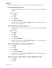
... to cycle through the backlight intensities.
(Alternate method)
1. Use the left side of the receiver) to conserve the battery life in your Magellan Triton. Use the left /right cursor
control to move the slider to 15s. Use the ..., highlight the Backlight Level slider. Select View. 3. Select Settings. 4. Disable the electronic compass if GPS fix is available. (Magellan Triton 500)
1.
Manual - English - Page 24
... screens displayed at the bottom of the screen as colored bars. The numbers indicate the GPS satellite ID while "W" indicates WAAS (Wide Area Augmentation System) satellites.
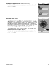
Green satellite icons represent...signal reception. The Altimeter / Barometer Screen (Magellan Triton 500)
The Altimeter / Barometer screen displays your current elevation and barometer readings. Navigation Screens
...
Manual - English - Page 26
... from the destination point, the numbers should be a negative distance if the user moves away from trees, tunnels, tall buildings, canyons, broadcast satellites, and other GPS receivers too close in distance) the progress the user has made .
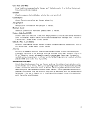
Average Speed
Average Speed calculates the average speed of error the user can expect based...
Manual - English - Page 27

...used screen in the direction of travel .)
Trail (Track that has been saved in the receiver.)
Start Flag (Indicates the starting point of the active route.)
End Flag (Indicates the ...the receiver. Default icon shown. Map Screen Overview
Battery Level
Time of Day
GPS Signal Strength
North Indicator
Data Fields
Map Scale
Pan Mode
Map Legend
Present Position Cursor (Points in the Magellan ...
Manual - English - Page 37
...the top of the screen. Using the Keyboard
29
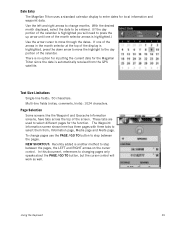
Date Entry
The Magellan Triton uses a standard calendar display to select different pages for the... pages. There is no option for inputting the current date for the Magellan Triton since the date is highlighted you will work as well. Multi-... calendar is automatically received from ; To change months. With the desired month displayed, select the ...
Manual - English - Page 39
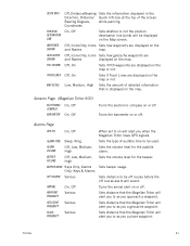
... off . Sets distance to be used. Sets distance that the Magellan Triton will alert you to as you when the Magellan Triton loses GPS signals. Off, Icons Only, Icons Sets how geocache waypoints are...Lines are displayed on the map or not.
Turns the arrival alert on the Map screen. Alarms Page
GPS FIX
On, Off
ALARM TONE
ALARM VOLUME
BEEPER VOLUME
Beep, Ring
Off, Low, Medium, High
Off,...
Manual - English - Page 46
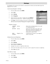
.... 4. Select Navigation. 5. The Map Datum used by the Magellan Triton should match the map datum that is being used for displaying... be used. Settings
The Magellan Triton gives you the means to use magnetic north or true north. From the Map screen press MENU. 2. Customizes the receiver to customize the receiver and view details about the Magellan Triton receiver.
Select Volume & Brightness...
Manual - English - Page 50

...can transfer.gpx files directly into the VantagePoint software and then transfer the information into your Magellan Triton either by creating a geocache waypoint or by saving the geocache file from the ... includes Difficulty (1 through 5 with 5 being the most difficult), Terrain (1 though 5 with GPS users. Select the the waypoint. Scroll down the page to display the Details page. Geocache ...
Manual - English - Page 53
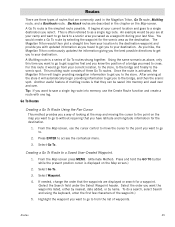
... a route with one leg. Select Waypoint.
4. Highlight the waypoint you to cross. The Magellan Triton would create a Go To route by name. After arriving at your current location and...present position cursor is a series of waypoints. Routes
45 As you hike, the Magellan Triton continuously updates the information giving you the best possible directions to get you to the store....
Manual - English - Page 61
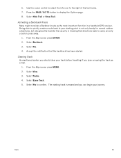
... the Map screen press ENTER. 2. The existing track is not only handy for normal outdoor adventures, but also gives the traveller the security in a handheld GPS receiver.
Being able to quickly create a route back to confirm. Select View. 3. Select Hide Trail or Show Trail.
Similar Questions

I Found A Magellan Roadmate 1200. Is It Possible To View Maps W/o An Sd Card?
I found a Magellan RoadMate 1200. Is it possible to view maps w/o an SD card?
I found a Magellan RoadMate 1200. Is it possible to view maps w/o an SD card?
(Posted by horseflybite9 1 year ago)

My Magellan Roadmate 1200 Is Stuck In Warning Page Hire Do I Get It Unstuck
can you my magellan roadmate 1200 unstuck
can you my magellan roadmate 1200 unstuck
(Posted by laura1972lm 8 years ago)

How To Update Magellan 1400 Free
(Posted by SCOjeffa 9 years ago)

How To Update Roadmate 1412 Map
(Posted by faithkashm 10 years ago)

Unlock Magellan Roadmate 1200
How do I unlock my Magellan Roadmate 1200
How do I unlock my Magellan Roadmate 1200
(Posted by sentahinzman 11 years ago)