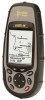
User Manual
Page 3
... replace the need for the accuracy and maintenance of Defense civil GPS user policy and the Federal Radionavigation Plan. Government, which you or others could be reproduced or transmitted in accordance with Thales Navigation GPS products (the "SOFTWARE") in this SOFTWARE except as expressly provided in the normal operation of non-Magellan cables and antennas may make any settings on one device for navigating...
... replace the need for the accuracy and maintenance of Defense civil GPS user policy and the Federal Radionavigation Plan. Government, which you or others could be reproduced or transmitted in accordance with Thales Navigation GPS products (the "SOFTWARE") in this SOFTWARE except as expressly provided in the normal operation of non-Magellan cables and antennas may make any settings on one device for navigating...
User Manual
Page 8
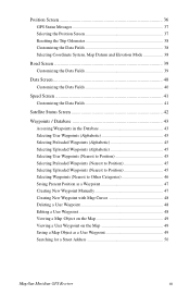
Position Screen 36 GPS Status Messages 37 Selecting the Position Screen 37 Resetting the Trip Odometer 38 Customizing the Data Fields 38 Selecting Coordinate System, Map Datum and Elevation Mode 38 Road Screen 39 Customizing the Data Fields 39 Data Screen 40 Customizing the Data Fields 40 Speed Screen 41 Customizing the Data Fields 41 Satellite Status Screen 42 Waypoints / Database 43 Accessing Waypoints in the Database 43 Selecting User Waypoints (Alphabetic 45 Selecting Preloaded Waypoints (Alphabetic 45 Selecting Uploaded Waypoints (Alphabetic 45 Selecting User Waypoints (...
Position Screen 36 GPS Status Messages 37 Selecting the Position Screen 37 Resetting the Trip Odometer 38 Customizing the Data Fields 38 Selecting Coordinate System, Map Datum and Elevation Mode 38 Road Screen 39 Customizing the Data Fields 39 Data Screen 40 Customizing the Data Fields 40 Speed Screen 41 Customizing the Data Fields 41 Satellite Status Screen 42 Waypoints / Database 43 Accessing Waypoints in the Database 43 Selecting User Waypoints (Alphabetic 45 Selecting Preloaded Waypoints (Alphabetic 45 Selecting Uploaded Waypoints (Alphabetic 45 Selecting User Waypoints (...
User Manual
Page 9
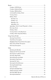
...Map Screen 56 Creating a Route using Track History 56 Using Vertical Profile 57 Selecting Vertical Profile 57 Track History Description 58 Highlighted Road Vertical Profile Description 58 Route Vertical Profile Description 58 Path Check Description 58 Setup ...59 Initializing the Meridian 59 Turning the NAV Screens On/Off 59 Selecting the Coordinate System 60 Selecting a Map Datum 60 Selecting the Elevation Mode 61 Selecting the Time Format 61 Selecting NAV Units 61 Selecting the North Reference 62 Selecting Daylight Savings 62 Power Off Timer 63 Setting the Backlight Timer...
...Map Screen 56 Creating a Route using Track History 56 Using Vertical Profile 57 Selecting Vertical Profile 57 Track History Description 58 Highlighted Road Vertical Profile Description 58 Route Vertical Profile Description 58 Path Check Description 58 Setup ...59 Initializing the Meridian 59 Turning the NAV Screens On/Off 59 Selecting the Coordinate System 60 Selecting a Map Datum 60 Selecting the Elevation Mode 61 Selecting the Time Format 61 Selecting NAV Units 61 Selecting the North Reference 62 Selecting Daylight Savings 62 Power Off Timer 63 Setting the Backlight Timer...
User Manual
Page 10
... the Power Key Settings 65 Selecting Languages 65 Clearing Memory 66 Clearing Track History 66 Clearing Wpts/Routes 66 Clearing All Routes 66 Resetting Meridian to Memory Card 71 Save Track ...71 Loading Waypoints and Routes from Memory Card 71 Loading Track from Memory Card 72 Deleting Files from Memory Card 72 Testing the Memory Card 72 Changing the Detailed Map 73 Formating the Memory Card 73 Magellan Meridian GPS Receiver v Auto Mode 70 Turning on the Simulator - User Mode 70 Turning the Simulator Off 70 Using the Card Utilities 71 Save Waypoints and Routes to Factory...
... the Power Key Settings 65 Selecting Languages 65 Clearing Memory 66 Clearing Track History 66 Clearing Wpts/Routes 66 Clearing All Routes 66 Resetting Meridian to Memory Card 71 Save Track ...71 Loading Waypoints and Routes from Memory Card 71 Loading Track from Memory Card 72 Deleting Files from Memory Card 72 Testing the Memory Card 72 Changing the Detailed Map 73 Formating the Memory Card 73 Magellan Meridian GPS Receiver v Auto Mode 70 Turning on the Simulator - User Mode 70 Turning the Simulator Off 70 Using the Card Utilities 71 Save Waypoints and Routes to Factory...
User Manual
Page 13
... that may have tried to external devices, accessories, troubleshooting and specifications can quickly and easily find the feature you will probably not find any new information in this chapter but new GPS users may find step-by mail. 2 Magellan Meridian GPS Receiver Reference Guide: Here you are looking for. Glossary: A glossary is to us through our web site (www.magellangps.com) or by -step instructions for all...
... that may have tried to external devices, accessories, troubleshooting and specifications can quickly and easily find the feature you will probably not find any new information in this chapter but new GPS users may find step-by mail. 2 Magellan Meridian GPS Receiver Reference Guide: Here you are looking for. Glossary: A glossary is to us through our web site (www.magellangps.com) or by -step instructions for all...
User Manual
Page 15
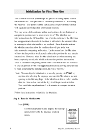
... the earth and if the Meridian has an approximate idea as "Initializing the Receiver." From this initializaion is able to collect satellite data (i.e., have a clear view of its location. This procedure is new (or when memory has been completely erased), the Meridian has no last position information. The purpose of setting up screen, followed by pressing the [NAV] key anytime after selecting the language you want the Meridian to use .
... the earth and if the Meridian has an approximate idea as "Initializing the Receiver." From this initializaion is able to collect satellite data (i.e., have a clear view of its location. This procedure is new (or when memory has been completely erased), the Meridian has no last position information. The purpose of setting up screen, followed by pressing the [NAV] key anytime after selecting the language you want the Meridian to use .
User Manual
Page 19
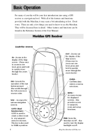
... in the Reference Section of the User Manual. Accesses the various navigation screens. Also used to create a direct route to any waypoint stored in detail. Don't worry. Quadrifilar Antenna IN - Also provides access to MARK a position. 8 OUT - PWR- Zooms out the display of the Map screen. (Press once to zoom out one level, press and hold to quickly move through the zoom levels.) ENTER Confirms data entries or menu selections. Magellan Meridian GPS Receiver Zooms in...
... in the Reference Section of the User Manual. Accesses the various navigation screens. Also used to create a direct route to any waypoint stored in detail. Don't worry. Quadrifilar Antenna IN - Also provides access to MARK a position. 8 OUT - PWR- Zooms out the display of the Map screen. (Press once to zoom out one level, press and hold to quickly move through the zoom levels.) ENTER Confirms data entries or menu selections. Magellan Meridian GPS Receiver Zooms in...
User Manual
Page 20
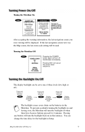
If the last navigation screen view was the Map screen, the last zoom scale setting will be set to press ENTER accepting the warning or the Meridian will cancel the power down sequence. The display backlight can change the time delay for the backlight in the Meridian. Pressing any button will turn off The backlight causes severe drain on in this instance. Magellan Meridian GPS Receiver 9 Press and hold for 2 seconds PWR Display backlight illuminates (low...
If the last navigation screen view was the Map screen, the last zoom scale setting will be set to press ENTER accepting the warning or the Meridian will cancel the power down sequence. The display backlight can change the time delay for the backlight in the Meridian. Pressing any button will turn off The backlight causes severe drain on in this instance. Magellan Meridian GPS Receiver 9 Press and hold for 2 seconds PWR Display backlight illuminates (low...
User Manual
Page 23
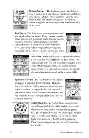
... speed in the upper six fields. Road Screen. The Road screen presents your heading and above that are using the coordinate systems that will be displayed relative to display the data that displays your route as well. 12 Magellan Meridian GPS Receiver Above the road is displayed in a familiar graphical format. The bottom of the basic position, time and satellite information. When you are four customizable data fields. This screen shows all of the screen contains a trip odometer...
... speed in the upper six fields. Road Screen. The Road screen presents your heading and above that are using the coordinate systems that will be displayed relative to display the data that displays your route as well. 12 Magellan Meridian GPS Receiver Above the road is displayed in a familiar graphical format. The bottom of the basic position, time and satellite information. When you are four customizable data fields. This screen shows all of the screen contains a trip odometer...
User Manual
Page 25
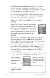
... the field above the keys. (Note: waypoint names can now use , press [ENTER]. The very top of the User Manual. Moves the highlight from one of waypoints named WPT001, WPT002, etc. from a list of your choosing. Highlight the Icon field using the map screen. Accepts the name and returns to the name you are entering and displayed in length.) Arrow keys - Clears the entire name. 14 Magellan Meridian GPS Receiver To...
... the field above the keys. (Note: waypoint names can now use , press [ENTER]. The very top of the User Manual. Moves the highlight from one of waypoints named WPT001, WPT002, etc. from a list of your choosing. Highlight the Icon field using the map screen. Accepts the name and returns to the name you are entering and displayed in length.) Arrow keys - Clears the entire name. 14 Magellan Meridian GPS Receiver To...
User Manual
Page 28
... the category you select in memory, either ones you have created or ones that you select. Magellan Meridian GPS Receiver 17 Selecting Alphabetical will now notice a thick line which is to provide you with the necessary details to get you to your present position or display the airports that are viewing the Map screen, you will display all the waypoints you are navigating to your destination, in...
... the category you select in memory, either ones you have created or ones that you select. Magellan Meridian GPS Receiver 17 Selecting Alphabetical will now notice a thick line which is to provide you with the necessary details to get you to your present position or display the airports that are viewing the Map screen, you will display all the waypoints you are navigating to your destination, in...
User Manual
Page 37
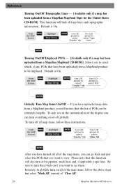
... above steps but select "Mark All" instead of "Clear All". 26 Magellan Meridian GPS Receiver From MENU the MAP Screen Highlight Map Setup ENTER Use L/R arrows to select "Display" tab Use U/D arrows to select Clear All ENTER After you have turned off globally. Reference Turning On/Off Topographic Lines - [Available only if a map has been uploaded from a MapSend product to be extremely lengthy. From MENU the MAP Screen Highlight Map Setup ENTER Use L/R arrows to select "Display" tab Use U/D arrows to turn off waypoints, track lines and...
... above steps but select "Mark All" instead of "Clear All". 26 Magellan Meridian GPS Receiver From MENU the MAP Screen Highlight Map Setup ENTER Use L/R arrows to select "Display" tab Use U/D arrows to select Clear All ENTER After you have turned off globally. Reference Turning On/Off Topographic Lines - [Available only if a map has been uploaded from a MapSend product to be extremely lengthy. From MENU the MAP Screen Highlight Map Setup ENTER Use L/R arrows to select "Display" tab Use U/D arrows to turn off waypoints, track lines and...
User Manual
Page 38
Reference Setting Up Map Data Fields - The following options are available ONLY if you are in the Position Mode and you have topographic information loaded a warning screen is displayed. Selecting the Map Information - Magellan Meridian GPS Receiver 27 Turning this off the information field that you were in , the simpliest way to determine it is to the map. From MENU the MAP Screen Highlight Select Map Info ENTER Use U/D arrows to turn on or off allows for more of the...
Reference Setting Up Map Data Fields - The following options are available ONLY if you are in the Position Mode and you have topographic information loaded a warning screen is displayed. Selecting the Map Information - Magellan Meridian GPS Receiver 27 Turning this off the information field that you were in , the simpliest way to determine it is to the map. From MENU the MAP Screen Highlight Select Map Info ENTER Use U/D arrows to turn on or off allows for more of the...
User Manual
Page 44
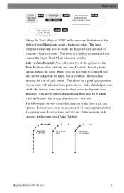
Track Mode Fixed Rate Track Mode Auto Track Mode Auto Detailed Magellan Meridian GPS Receiver 33 The same temporary waypoints used to create the displayed track are Auto (default) and Auto Detailed. Auto vs. Basically, both options behave the same. This allows a more detail on turns and still not clutter memory with minimal track points stored. Reference From MENU the MAP Screen Highlight Map Setup ENTER Use arrows to ENTER highlight the "Track Mode" field Use arrows to ENTER NAV select Mode Setting the Track Mode to "OFF" will notice two of the options for a good...
Track Mode Fixed Rate Track Mode Auto Track Mode Auto Detailed Magellan Meridian GPS Receiver 33 The same temporary waypoints used to create the displayed track are Auto (default) and Auto Detailed. Auto vs. Basically, both options behave the same. This allows a more detail on turns and still not clutter memory with minimal track points stored. Reference From MENU the MAP Screen Highlight Map Setup ENTER Use arrows to ENTER highlight the "Track Mode" field Use arrows to ENTER NAV select Mode Setting the Track Mode to "OFF" will notice two of the options for a good...
User Manual
Page 60
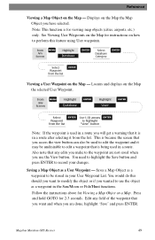
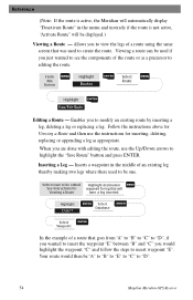
... changes. From Any Screen MENU Highlight Database ENTER Highlight User ENTER Select ENTER Use U/D arrows ENTER Waypoint to highlight from the list "View" button Note: If the waypoint is being used in a route you make to perform this should you want and when you are not saved when you use the object as a waypoint in a route. You would do this feature using User waypoints. Magellan Meridian GPS Receiver 49 Follow the instructions above for instructions on the Map - Locates and displays on a Map. See Viewing User Waypoints...
... changes. From Any Screen MENU Highlight Database ENTER Highlight User ENTER Select ENTER Use U/D arrows ENTER Waypoint to highlight from the list "View" button Note: If the waypoint is being used in a route you make to perform this should you want and when you are not saved when you use the object as a waypoint in a route. You would do this feature using User waypoints. Magellan Meridian GPS Receiver 49 Follow the instructions above for instructions on the Map - Locates and displays on a Map. See Viewing User Waypoints...
User Manual
Page 62
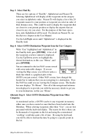
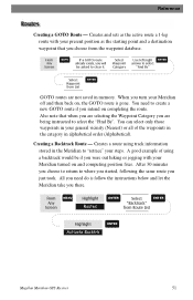
... need do is follow the instructions below and let the Meridian take you turn your Meridian turned on and computing position fixes. Select Waypoint Category Use left/right ENTER arrows to create a new GOTO route if you just took. A good example of the waypoints in the category in memory. Reference Creating a GOTO Route - Creates and sets as the starting point and a destination waypoint that when you are selecting the Waypoint Category you choose from the...
... need do is follow the instructions below and let the Meridian take you turn your Meridian turned on and computing position fixes. Select Waypoint Category Use left/right ENTER arrows to create a new GOTO route if you just took. A good example of the waypoints in the category in memory. Reference Creating a GOTO Route - Creates and sets as the starting point and a destination waypoint that when you are selecting the Waypoint Category you choose from the...
User Manual
Page 65
... insert waypoint "E". Select route to be "A" to "B" to "E" to "C" to create the route. Highlight destination MENU See Instructions for waypoint for inserting, deleting, replacing or appending a leg as a precursor to modify an existing route by inserting a leg, deleting a leg or replacing a leg. Enables you just wanted to see the components of an existing leg thereby making two legs where there used to "D". 54 Magellan Meridian GPS Receiver When...
... insert waypoint "E". Select route to be "A" to "B" to "E" to "C" to create the route. Highlight destination MENU See Instructions for waypoint for inserting, deleting, replacing or appending a leg as a precursor to modify an existing route by inserting a leg, deleting a leg or replacing a leg. Enables you just wanted to see the components of an existing leg thereby making two legs where there used to "D". 54 Magellan Meridian GPS Receiver When...
User Manual
Page 74
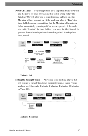
... Time Select time ENTER from list Default: Off Setting the Backlight Timer - From Any Screen MENU Highlight Setup ENTER Highlight Light Timer ENTER Select Timer Duration ENTER Default: 4 Minutes Magellan Meridian GPS Receiver 63 Conserving battery life is "Position", the timer field sets how soon the Meridian will remain on . Selecting "On" will stay powered on before automatically powering off if no keys have been pressed. From any GPS user and the power off the display backlight when not in saving battery life. Times available are pressed. If the mode selected...
... Time Select time ENTER from list Default: Off Setting the Backlight Timer - From Any Screen MENU Highlight Setup ENTER Highlight Light Timer ENTER Select Timer Duration ENTER Default: 4 Minutes Magellan Meridian GPS Receiver 63 Conserving battery life is "Position", the timer field sets how soon the Meridian will remain on . Selecting "On" will stay powered on before automatically powering off if no keys have been pressed. From any GPS user and the power off the display backlight when not in saving battery life. Times available are pressed. If the mode selected...
User Manual
Page 89
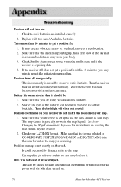
... antenna is in the map legend. If there are using . Make sure that the format selected in COORDINATE SYSTEM (DEG/MIN/SEC or DEG/MIN.MM) is pointing up to a new location. 2. Turn the receiver back on . 78 Magellan Meridian GPS Receiver Position on the road. Battery life seems shorter than 10 minutes to the map. Use map data for instructions on it should operate normally. If the receiver still does not get...
... antenna is in the map legend. If there are using . Make sure that the format selected in COORDINATE SYSTEM (DEG/MIN/SEC or DEG/MIN.MM) is pointing up to a new location. 2. Turn the receiver back on . 78 Magellan Meridian GPS Receiver Position on the road. Battery life seems shorter than 10 minutes to the map. Use map data for instructions on it should operate normally. If the receiver still does not get...
User Manual
Page 103
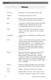
... current elevation above sea level. The direction you should be traveling in water. It is a "compromise" course bearing that is moving. Map makers may use WGS84. Course Over Ground. Course to the nearest degree. Distance. Estimated Time of the earth's sea level surface. The estimated time of which datum to use, use a different model to destination. Distance from your position and the current leg destination waypoint. Magellan Meridian GPS Receiver The compass direction from position to chart their maps, so position coordinates...
... current elevation above sea level. The direction you should be traveling in water. It is a "compromise" course bearing that is moving. Map makers may use WGS84. Course Over Ground. Course to the nearest degree. Distance. Estimated Time of the earth's sea level surface. The estimated time of which datum to use, use a different model to destination. Distance from your position and the current leg destination waypoint. Magellan Meridian GPS Receiver The compass direction from position to chart their maps, so position coordinates...


