User Manual
Page 15
... Explorer® Mobile 155 10.9 Windows Live 157 10.10 Using Your Device as a Modem (Internet Sharing 162 10.11 Bluetooth 164 Chapter 11 Using GPS 173 11.1 Guidelines and Preparation for Using GPS 174 11.2 Downloading Satellite Data via QuickGPS 176 11.3 Using TomTom NAVIGATOR 178 11...
... Explorer® Mobile 155 10.9 Windows Live 157 10.10 Using Your Device as a Modem (Internet Sharing 162 10.11 Bluetooth 164 Chapter 11 Using GPS 173 11.1 Guidelines and Preparation for Using GPS 174 11.2 Downloading Satellite Data via QuickGPS 176 11.3 Using TomTom NAVIGATOR 178 11...

User Manual
Page 19
.../GSM/GPRS standby, message, and network status as well as for GPS status. Left LED: Shows a flashing blue light for Wi-Fi status. Shows flashing amber light for notification and battery charging status. Touch Screen TALK Press to answer an incoming call conversations, or to take... a self-portrait. Notification LEDs * See description below. GPS Button Press to end a call from here. Shows a flashing red light when...
.../GSM/GPRS standby, message, and network status as well as for GPS status. Left LED: Shows a flashing blue light for Wi-Fi status. Shows flashing amber light for notification and battery charging status. Touch Screen TALK Press to answer an incoming call conversations, or to take... a self-portrait. Notification LEDs * See description below. GPS Button Press to end a call from here. Shows a flashing red light when...

User Manual
Page 20
Back Cover Slide the back cover downward to audio media. Speaker 3 Megapixel Camera See Chapter 12 for better GPS signal reception. Self-portrait Mirror Bottom Panel RESET Press the RESET button with model number GA S120. You can also connect the supplied ...USB stereo headset for hands-free conversation or for listening to remove it. 20 Getting Started Back panel GPS Antenna Connector Peel off the rubber cap and connect an external GPS antenna for details. Lanyard/Strap Holder Microphone Sync Connector/Earphone Jack Connect the supplied USB cable to synchronize information...
Back Cover Slide the back cover downward to audio media. Speaker 3 Megapixel Camera See Chapter 12 for better GPS signal reception. Self-portrait Mirror Bottom Panel RESET Press the RESET button with model number GA S120. You can also connect the supplied ...USB stereo headset for hands-free conversation or for listening to remove it. 20 Getting Started Back panel GPS Antenna Connector Peel off the rubber cap and connect an external GPS antenna for details. Lanyard/Strap Holder Microphone Sync Connector/Earphone Jack Connect the supplied USB cable to synchronize information...

User Manual
Page 48
... inquiry, and more details. Tasks Keep track of your ring tone. You can also use this program to measure the amount of your current GPS position. TomTom NAVIGATOR GPS navigation software that you to speed up the time for determining your data. You can dial a phone number or launch programs by your...
... inquiry, and more details. Tasks Keep track of your ring tone. You can also use this program to measure the amount of your current GPS position. TomTom NAVIGATOR GPS navigation software that you to speed up the time for determining your data. You can dial a phone number or launch programs by your...

User Manual
Page 51
...device is in Chapter 13. Memory Check the device memory allocation status and memory card information. Getting Started 51 Icon Description External GPS Set the appropriate GPS communication ports, if required. You may need to Microsoft's Web site and update Windows Mobile® on by accident and consume.... See Help for details. Long Press End Key Lets you set the ( ) button to end programs immediately when you have connected a GPS receiver to conserve battery power. You can also stop currently running programs and set the behavior when you press and hold the END key....
...device is in Chapter 13. Memory Check the device memory allocation status and memory card information. Getting Started 51 Icon Description External GPS Set the appropriate GPS communication ports, if required. You may need to Microsoft's Web site and update Windows Mobile® on by accident and consume.... See Help for details. Long Press End Key Lets you set the ( ) button to end programs immediately when you have connected a GPS receiver to conserve battery power. You can also stop currently running programs and set the behavior when you press and hold the END key....

User Manual
Page 173
Chapter 11 Using GPS 11.1 Guidelines and Preparation for Using GPS 11.2 Downloading Satellite Data via QuickGPS 11.3 Using TomTom NAVIGATOR 11.4 GPS Controls
Chapter 11 Using GPS 11.1 Guidelines and Preparation for Using GPS 11.2 Downloading Satellite Data via QuickGPS 11.3 Using TomTom NAVIGATOR 11.4 GPS Controls
User Manual
Page 174
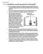
... of the system. For better signal reception, connect your device in unstable signal reception. • The Global Positioning System (GPS) is built and operated by obstructions such as mobile phones or radardetecting devices) may affect the accuracy and function of the system.... • The GPS signal cannot pass through . External GPS antenna connector • Wireless communication products (such as high-rise buildings, tunnels, bridges, forests, weather (rainy or ...
... of the system. For better signal reception, connect your device in unstable signal reception. • The Global Positioning System (GPS) is built and operated by obstructions such as mobile phones or radardetecting devices) may affect the accuracy and function of the system.... • The GPS signal cannot pass through . External GPS antenna connector • Wireless communication products (such as high-rise buildings, tunnels, bridges, forests, weather (rainy or ...

User Manual
Page 175
Using GPS 175 • When using the device inside a vehicle, use the car holder to mount the device securely in the holder. Avoid placing the device in the areas shown in the following diagram: 1 Do not place where it will block the driver's vision. 2 Do not place where air bags could deploy. 3 Do not place anywhere in the vehicle without securing the device in place.
Using GPS 175 • When using the device inside a vehicle, use the car holder to mount the device securely in the holder. Avoid placing the device in the areas shown in the following diagram: 1 Do not place where it will block the driver's vision. 2 Do not place where air bags could deploy. 3 Do not place anywhere in the vehicle without securing the device in place.

User Manual
Page 176
...your device for determining your device. To download data Tap Download on your device, which can be shown. To speed up the time for GPS navigation, open QuickGPS Tap Start > Programs > QuickGPS. QuickGPS downloads ephemeris data from a Web server, instead of from the satellites, using the... use your current location. This data is needed to download ephemeris data (current satellite position and timing information) onto your GPS position. 176 Using GPS 11.2 Downloading Satellite Data via ActiveSync or 3G/GPRS. As time passes, the remaining days and hours of the downloaded data....
...your device for determining your device. To download data Tap Download on your device, which can be shown. To speed up the time for GPS navigation, open QuickGPS Tap Start > Programs > QuickGPS. QuickGPS downloads ephemeris data from a Web server, instead of from the satellites, using the... use your current location. This data is needed to download ephemeris data (current satellite position and timing information) onto your GPS position. 176 Using GPS 11.2 Downloading Satellite Data via ActiveSync or 3G/GPRS. As time passes, the remaining days and hours of the downloaded data....
User Manual
Page 177
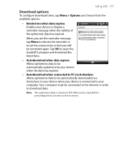
Using GPS 177 Download options To configure download times, tap Menu > Options and choose from the available options: • Remind me when data expires. QuickGPS is preconfigured ... data has expired. Allows ephemeris data to be reminded again. Note The ephemeris data is connected to download data. Enables your device is stored on HTC Web servers. When you will be automatically updated onto your computer. Your computer must be automatically downloaded via ActiveSync. Allows ephemeris data to be connected...
Using GPS 177 Download options To configure download times, tap Menu > Options and choose from the available options: • Remind me when data expires. QuickGPS is preconfigured ... data has expired. Allows ephemeris data to be reminded again. Note The ephemeris data is connected to download data. Enables your device is stored on HTC Web servers. When you will be automatically updated onto your computer. Your computer must be automatically downloaded via ActiveSync. Allows ephemeris data to be connected...

User Manual
Page 178
...your desired answer on the destination address you specified, a contact you selected, a point of your choice for a trip. 178 Using GPS 11.3 Using TomTom NAVIGATOR TomTom NAVIGATOR is a GPS navigation software that provides clear routing directions and vocal instructions to guide you in advance. Places that the built-in... GPS receiver can determine your current position. First-time use The first time you use the Map Browser to familiarize yourself first ...
...your desired answer on the destination address you specified, a contact you selected, a point of your choice for a trip. 178 Using GPS 11.3 Using TomTom NAVIGATOR TomTom NAVIGATOR is a GPS navigation software that provides clear routing directions and vocal instructions to guide you in advance. Places that the built-in... GPS receiver can determine your current position. First-time use The first time you use the Map Browser to familiarize yourself first ...

User Manual
Page 179
...position. 4 5 Shows an arrow that indicates the direction that you are in black and white until your device's GPS receiver locates your current position. Tip For your GPS receiver to determine your current position faster, use QuickGPS first to download the latest ephemeris data to your position will be... found much faster, normally within a few seconds. Using GPS 179 If it takes longer than 5 minutes, make sure that you should follow, and shows the distance from your current position to the...
...position. 4 5 Shows an arrow that indicates the direction that you are in black and white until your device's GPS receiver locates your current position. Tip For your GPS receiver to determine your current position faster, use QuickGPS first to download the latest ephemeris data to your position will be... found much faster, normally within a few seconds. Using GPS 179 If it takes longer than 5 minutes, make sure that you should follow, and shows the distance from your current position to the...

User Manual
Page 180
... Itinerary planning. Enables and disables reception of icons. Allows you to avoid traffic or other nuisances. • TomTom Traffic. 180 Using GPS Main Menu Tap anywhere on the map in the Driving View screen to add frequently visited places as favorites. • Change preferences. Deletes... for phone numbers of the journey. • Browse map. Shows your final destination. • TomTom Weather. Closes TomTom NAVIGATOR and the GPS navigation. Allows you to determine how long a journey will take and the route of the places that you can customize settings. • ...
... Itinerary planning. Enables and disables reception of icons. Allows you to avoid traffic or other nuisances. • TomTom Traffic. 180 Using GPS Main Menu Tap anywhere on the map in the Driving View screen to add frequently visited places as favorites. • Change preferences. Deletes... for phone numbers of the journey. • Browse map. Shows your final destination. • TomTom Weather. Closes TomTom NAVIGATOR and the GPS navigation. Allows you to determine how long a journey will take and the route of the places that you can customize settings. • ...
User Manual
Page 181
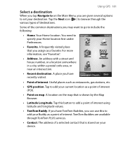
...Useful places such as a point of interest (POI). • Point on map. Tap to add your current location as restaurants, gas stations, etc. • GPS position. An address with a street and house number, or a location somewhere in a city, within a postal code area, or near an intersection. • ... to add your Buddy as a favorite. A frequently visited place that is shown by the Map Browser. • Latitude Longitude. Using GPS 181 Select a destination When you tap Navigate to on your device. TomTom Buddies are given several options to set your Home location first under...
...Useful places such as a point of interest (POI). • Point on map. Tap to add your current location as restaurants, gas stations, etc. • GPS position. An address with a street and house number, or a location somewhere in a city, within a postal code area, or near an intersection. • ... to add your Buddy as a favorite. A frequently visited place that is shown by the Map Browser. • Latitude Longitude. Using GPS 181 Select a destination When you tap Navigate to on your device. TomTom Buddies are given several options to set your Home location first under...

User Manual
Page 182
... so that you often visit. You can then select one of traffic, or stop by another road), Minimise traffic delays, etc. Tap Done. 182 Using GPS After you have to specify the address every time you need to arrive at a particular time. NAVIGATOR then calculates the route and displays the Route...
... so that you often visit. You can then select one of traffic, or stop by another road), Minimise traffic delays, etc. Tap Done. 182 Using GPS After you have to specify the address every time you need to arrive at a particular time. NAVIGATOR then calculates the route and displays the Route...
User Manual
Page 183
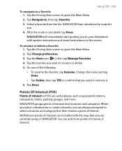
... of interest, if desired. Tap Change preferences. 3. NAVIGATOR groups points of the following: • To rename the favorite, tap Rename. Tap Navigate to a favorite 1. Using GPS 183 To navigate to , then tap Favorite. 3. Tap the Driving View screen to your destination with the map that you . 4.
... of interest, if desired. Tap Change preferences. 3. NAVIGATOR groups points of the following: • To rename the favorite, tap Rename. Tap Navigate to a favorite 1. Using GPS 183 To navigate to , then tap Favorite. 3. Tap the Driving View screen to your destination with the map that you . 4.

User Manual
Page 184
... have to use. Tap the POI category you choose a destination (for example, choose Home, Address, etc.). To add a category, tap Add POI category. 4. 184 Using GPS POI locations POI categories To add a point of your POI category. (This marker will be shown on the map). 5. Enter a name for your POI category...
... have to use. Tap the POI category you choose a destination (for example, choose Home, Address, etc.). To add a category, tap Add POI category. 4. 184 Using GPS POI locations POI categories To add a point of your POI category. (This marker will be shown on the map). 5. Enter a name for your POI category...
User Manual
Page 185
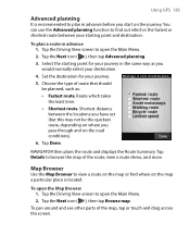
To plan a route in the same way as : • Fastest route. Set the destination for your journey in advance 1. To open the Main Menu. 2. Using GPS 185 Advanced planning It is recommended to plan in advance before you start on the road conditions). 6. Choose the type of the route, view a route ... on the journey. Tap the Driving View screen to open the Main Menu. 2. To pan around and see other parts of the map, tap or touch and drag across the screen. You can use the Advanced planning function to view a route on the map or find out which takes the least...
To plan a route in the same way as : • Fastest route. Set the destination for your journey in advance 1. To open the Main Menu. 2. Using GPS 185 Advanced planning It is recommended to plan in advance before you start on the road conditions). 6. Choose the type of the route, view a route ... on the journey. Tap the Driving View screen to open the Main Menu. 2. To pan around and see other parts of the map, tap or touch and drag across the screen. You can use the Advanced planning function to view a route on the map or find out which takes the least...

User Manual
Page 186
... colors on the map. 7 This is the Cursor button. To switch back to seeing the map from your current position on the map. 186 Using GPS 1 3 1 This Scale Bar shows the distance range shown on the map based on the current zoom scale. 2 2 This is your perspective as you see only...
... colors on the map. 7 This is the Cursor button. To switch back to seeing the map from your current position on the map. 186 Using GPS 1 3 1 This Scale Bar shows the distance range shown on the map based on the current zoom scale. 2 2 This is your perspective as you see only...

User Manual
Page 187
...Volume preferences Manage Favorites Change Home location Manage maps Manage POIs Planning preferences Toll road preferences Compass preferences Change map colors Show GPS status Keyboard preferences Name preferences Status bar preferences Set units Operate lefthanded Description Allows you to choose which can choose to .... Lets you select a destination. Lets you to download or delete a map, or switch to another map. Displays information about the GPS signal. Allows you select the information to select the keyboard size and layout. To turn the voice back on, tap Turn on the...
...Volume preferences Manage Favorites Change Home location Manage maps Manage POIs Planning preferences Toll road preferences Compass preferences Change map colors Show GPS status Keyboard preferences Name preferences Status bar preferences Set units Operate lefthanded Description Allows you to choose which can choose to .... Lets you select a destination. Lets you to download or delete a map, or switch to another map. Displays information about the GPS signal. Allows you select the information to select the keyboard size and layout. To turn the voice back on, tap Turn on the...


