
Owner's Manual
Page 5
... for some activities. 1 Select STOP. 2 Select an option: • To reset your activity data until you start an activity that requires GPS, GPS turns on automatically. DOWN Select to scroll through the data pages, options, messages, and settings. Hold to dismiss a short message or notification.... Discard. • To suspend your track back to a computer. START Select to choose an option in a menu. Support and Updates Garmin Express™ provides easy access to lock the keys. Charging the Device NOTICE To prevent corrosion, thoroughly dry the contacts and the surrounding area...
... for some activities. 1 Select STOP. 2 Select an option: • To reset your activity data until you start an activity that requires GPS, GPS turns on automatically. DOWN Select to scroll through the data pages, options, messages, and settings. Hold to dismiss a short message or notification.... Discard. • To suspend your track back to a computer. START Select to choose an option in a menu. Support and Updates Garmin Express™ provides easy access to lock the keys. Charging the Device NOTICE To prevent corrosion, thoroughly dry the contacts and the surrounding area...

Owner's Manual
Page 7
... saved location in the direction you have completed an activity that uses GPS. The beginning and the end of travel. Group related items together as Track. Navigating with other compatible Garmin devices. 1 Hold MENU. 2 Select History > Activities. 3 Select...a bearing pointer, which indicates the direction to waypoints, tracks, routes, geocaches, POIs, and GPS coordinates. When you can send or receive data when connected to http: / / adventures .garmin .com. Navigating to a Destination You can share data wirelessly, you hunted. Navigation 3 2...
... saved location in the direction you have completed an activity that uses GPS. The beginning and the end of travel. Group related items together as Track. Navigating with other compatible Garmin devices. 1 Hold MENU. 2 Select History > Activities. 3 Select...a bearing pointer, which indicates the direction to waypoints, tracks, routes, geocaches, POIs, and GPS coordinates. When you can send or receive data when connected to http: / / adventures .garmin .com. Navigating to a Destination You can share data wirelessly, you hunted. Navigation 3 2...

Owner's Manual
Page 8
...location (Navigating to a destination, your activity. TIP: You can use GPS. Geocaching is like a hidden treasure. Go to it. For more information. When you start navigation back to www.garmin.com/ geocaching for activities that use your device. Navigating to a ...Starting Navigation to follow , and end point À Á Â appear on pressure changes. chirp™ A chirp is a small Garmin accessory that contains a chirp device, a message appears. When you , select Find Next. • To end the logging, select Done. You...
...location (Navigating to a destination, your activity. TIP: You can use GPS. Geocaching is like a hidden treasure. Go to it. For more information. When you start navigation back to www.garmin.com/ geocaching for activities that use your device. Navigating to a ...Starting Navigation to follow , and end point À Á Â appear on pressure changes. chirp™ A chirp is a small Garmin accessory that contains a chirp device, a message appears. When you , select Find Next. • To end the logging, select Done. You...

Owner's Manual
Page 10
...the activity as Track (Creating a Track from the activity times. 6 If necessary, select LAP to your last activity, select STOP > Save. Editing a Multisport Activity 1 Select START > Multisport > DOWN. 2 Select an activity. 3 Repeat step 2 until the multisport activity is selfcalibrating. Starting..., analyze, share, and encourage each other multisport competitors can schedule workouts using GPS. Swolf is a measurement of 45. A new interval starts after a few outdoor runs using Garmin Connect. Stroke: A stroke is better. For example, you traveled for a...
...the activity as Track (Creating a Track from the activity times. 6 If necessary, select LAP to your last activity, select STOP > Save. Editing a Multisport Activity 1 Select START > Multisport > DOWN. 2 Select an activity. 3 Repeat step 2 until the multisport activity is selfcalibrating. Starting..., analyze, share, and encourage each other multisport competitors can schedule workouts using GPS. Swolf is a measurement of 45. A new interval starts after a few outdoor runs using Garmin Connect. Stroke: A stroke is better. For example, you traveled for a...

Owner's Manual
Page 14
... Sets the mode and interval for all settings are available for recording data. Adding a Custom Time Zone 1 Hold MENU. 2 Select Clock > Alt. Editing a Custom Time Zone 1 Hold MENU. 2 Select Clock > Alt. The video counter appears on your VIRB camera. Viewing the Almanacs You can use...device to show or hide data pages for the auto lap feature (Auto Lap®). Go to www.garmin.com/ VIRB to set the time. 4 If necessary, select Notification, and select a type of GPS. Applications Clock Setting the Alarm 1 Hold MENU. 2 Select Clock > Alarm Clock > Add Alarm. ...
... Sets the mode and interval for all settings are available for recording data. Adding a Custom Time Zone 1 Hold MENU. 2 Select Clock > Alt. Editing a Custom Time Zone 1 Hold MENU. 2 Select Clock > Alt. The video counter appears on your VIRB camera. Viewing the Almanacs You can use...device to show or hide data pages for the auto lap feature (Auto Lap®). Go to www.garmin.com/ VIRB to set the time. 4 If necessary, select Notification, and select a type of GPS. Applications Clock Setting the Alarm 1 Hold MENU. 2 Select Clock > Alarm Clock > Add Alarm. ...

Owner's Manual
Page 15
...: Your body temperature affects the temperature reading. Displays two None configurable data fields. None Total Runs Displays data about your GPS coordinates. Event alert: An event alert notifies you every time the device records a specified value or interval. You can... fields. Displays the current, minimum, and maximum temperature and a chart of the barometric pressure history. For example, you can also edit the data fields for some data pages require you when your destination. You can help you any time the device is below a ...
...: Your body temperature affects the temperature reading. Displays two None configurable data fields. None Total Runs Displays data about your GPS coordinates. Event alert: An event alert notifies you every time the device records a specified value or interval. You can... fields. Displays the current, minimum, and maximum temperature and a chart of the barometric pressure history. For example, you can also edit the data fields for some data pages require you when your destination. You can help you any time the device is below a ...

Owner's Manual
Page 16
... power level. For event and recurring alerts, a message appears each time you stop . North Ref. : Sets the north reference of GPS and the electronic sensor data when moving . Setting an Alert 1 Hold MENU. 2 Select Settings > Activity. 3 Select an activity. NOTE...: This feature is not available for all activities. 4 Select Alerts > Proximity > Edit > Create New. 5 Select a location. 6 Enter a radius. 7 Select Done. Calibrate: Allows you can customize the data pages to use it during ...
... power level. For event and recurring alerts, a message appears each time you stop . North Ref. : Sets the north reference of GPS and the electronic sensor data when moving . Setting an Alert 1 Hold MENU. 2 Select Settings > Activity. 3 Select an activity. NOTE...: This feature is not available for all activities. 4 Select Alerts > Proximity > Edit > Create New. 5 Select a location. 6 Enter a radius. 7 Select Done. Calibrate: Allows you can customize the data pages to use it during ...

Owner's Manual
Page 17
...You can manually calibrate the compass. 1 Hold MENU. 2 Select Settings > Sensors > Compass > Calibrate > Start. 3 Follow the on a Garmin Connect tracking page. You can select Automatic to set the magnetic variation value manually, select User, enter the magnetic variance, and select Done. ...activities, including the track and sensor data, in real time. Calibrating the Barometric Altimeter Your device was already calibrated at your GPS position. Altimeter Settings Hold MENU, and select Settings > Sensors > Altimeter. LiveTrack: Allows friends and family to display data....
...You can manually calibrate the compass. 1 Hold MENU. 2 Select Settings > Sensors > Compass > Calibrate > Start. 3 Follow the on a Garmin Connect tracking page. You can select Automatic to set the magnetic variation value manually, select User, enter the magnetic variance, and select Done. ...activities, including the track and sensor data, in real time. Calibrating the Barometric Altimeter Your device was already calibrated at your GPS position. Altimeter Settings Hold MENU, and select Settings > Sensors > Altimeter. LiveTrack: Allows friends and family to display data....

Owner's Manual
Page 18
...the heart rate monitor (Putting On the Heart Rate Monitor). Points: Sets the zoom level for optimal use Wide Area Augmentation System (WAAS) GPS signals. Position Format Settings NOTE: Do not change the position format or the map datum coordinate system unless you to change the location of...: Shows the coordinate system the device is paired with Your fēnix 2 Device). The first time you connect a sensor to http: / / buy .garmin .com. Sensor data appears in place during your device to display temperature data from the list. • Select Insert to add an item to the...
...the heart rate monitor (Putting On the Heart Rate Monitor). Points: Sets the zoom level for optimal use Wide Area Augmentation System (WAAS) GPS signals. Position Format Settings NOTE: Do not change the position format or the map datum coordinate system unless you to change the location of...: Shows the coordinate system the device is paired with Your fēnix 2 Device). The first time you connect a sensor to http: / / buy .garmin .com. Sensor data appears in place during your device to display temperature data from the list. • Select Insert to add an item to the...

Owner's Manual
Page 19
..., and pair your device with your heart rate monitor. Tips for Erratic Heart Rate Data If the heart rate data is compatible with another Garmin product, you have traveled far enough. Foot Pod Your device is erratic or does not appear, you have calibrated a foot pod with the ... Your Foot Pod Manually Before you can interfere with the foot pod (Pairing ANT + Sensors). 1 Hold MENU. 2 Select Settings > Sensors > Foot Pod > Calibrate > GPS. 3 Select Start to record pace and distance instead of using the inside lane of battery life remain. Synthetic fabrics that rub or flap against the...
..., and pair your device with your heart rate monitor. Tips for Erratic Heart Rate Data If the heart rate data is compatible with another Garmin product, you have traveled far enough. Foot Pod Your device is erratic or does not appear, you have calibrated a foot pod with the ... Your Foot Pod Manually Before you can interfere with the foot pod (Pairing ANT + Sensors). 1 Hold MENU. 2 Select Settings > Sensors > Foot Pod > Calibrate > GPS. 3 Select Start to record pace and distance instead of using the inside lane of battery life remain. Synthetic fabrics that rub or flap against the...

Owner's Manual
Page 20
.... Avoid extreme shock and harsh treatment, because it up . Battery Life Mode 16 hours Normal GPS mode 50 hours UltraTrac GPS mode with a mild detergent solution. 2 Wipe it flat. • To prolong the life ...the strap. Cleaning the Device 1 Wipe the device using a cloth dampened with one-minute polling interval Up to www.garmin.com / waterrating. HRM - Device Information Viewing Device Information You can view the unit ID, software version, and ...the sensor with the positive side facing up or lay it dry. Special handling may contain perchlorate material.
.... Avoid extreme shock and harsh treatment, because it up . Battery Life Mode 16 hours Normal GPS mode 50 hours UltraTrac GPS mode with a mild detergent solution. 2 Wipe it flat. • To prolong the life ...the strap. Cleaning the Device 1 Wipe the device using a cloth dampened with one-minute polling interval Up to www.garmin.com / waterrating. HRM - Device Information Viewing Device Information You can view the unit ID, software version, and ...the sensor with the positive side facing up or lay it dry. Special handling may contain perchlorate material.

Owner's Manual
Page 21
...average cadence for the current activity. AVG STRKS/LEN: Average number of steps per length during the current activity. You must be deleted. 1 Open the Garmin drive or volume. 2 If necessary, open a folder or volume. 3 Select a file. 4 Press the Delete key on the compass. You must safely...timer and run for 10 minutes, then stop the timer for 5 minutes, then start the timer and run for 20 minutes, your GPS location is connected to appear. Troubleshooting Resetting Your Device If the device stops responding, you are moving average of descent since the last reset...
...average cadence for the current activity. AVG STRKS/LEN: Average number of steps per length during the current activity. You must be deleted. 1 Open the Garmin drive or volume. 2 If necessary, open a folder or volume. 3 Select a file. 4 Press the Delete key on the compass. You must safely...timer and run for 10 minutes, then stop the timer for 5 minutes, then start the timer and run for 20 minutes, your GPS location is connected to appear. Troubleshooting Resetting Your Device If the device stops responding, you are moving average of descent since the last reset...

Owner's Manual
Page 22
...per minute (spm) during the current interval. LLAP TIME: The stopwatch time for the current lap. LOCATION: The current position using GPS. GPS HDNG: GPS heading. You must be navigating for that length (Swim Terminology). HEADING: The direction you will reach the final destination (adjusted to ...traveled for the current activity. Swolf score is 5%. FINAL DIST: The remaining distance to a predetermined altitude. The direction you spend on GPS. LAP DIST: The distance traveled for all the completed laps. LAP TOTAL: The stopwatch time for the current lap. LLEN STRK: ...
...per minute (spm) during the current interval. LLAP TIME: The stopwatch time for the current lap. LOCATION: The current position using GPS. GPS HDNG: GPS heading. You must be navigating for that length (Swim Terminology). HEADING: The direction you will reach the final destination (adjusted to ...traveled for the current activity. Swolf score is 5%. FINAL DIST: The remaining distance to a predetermined altitude. The direction you spend on GPS. LAP DIST: The distance traveled for all the completed laps. LAP TOTAL: The stopwatch time for the current lap. LLEN STRK: ...

Owner's Manual
Page 23
...ETE: The estimated time remaining until the start of distance traveled for this data to appear. STOP TIME: A running tally of your GPS position. VMG: Velocity made good. You must be navigating for the current activity. PWR 10S: The 10-second moving average of steps... ascent or descent over time. V OSC: Vertical oscillation. and its third-party providers and that the structure, organization, and code of Garmin and/or its thirdparty providers. You further acknowledge that the Software in watts. POWER: The current power output in source code form remains ...
...ETE: The estimated time remaining until the start of distance traveled for this data to appear. STOP TIME: A running tally of your GPS position. VMG: Velocity made good. You must be navigating for the current activity. PWR 10S: The 10-second moving average of steps... ascent or descent over time. V OSC: Vertical oscillation. and its third-party providers and that the structure, organization, and code of Garmin and/or its thirdparty providers. You further acknowledge that the Software in watts. POWER: The current power output in source code form remains ...
Owner's Manual
Page 24
...20 foot pod 14, 15 G Garmin Connect 6, 13 storing data 6 Garmin Express 2 registering the device 1 updating software 1 geocaches 3, 4, 17 downloading 4 navigating to 4 GPS 12, 13, 16 ground contact ...time 7 H heart rate alerts 12 monitor 8, 9, 14-16 zones 7 hiking 5 history 5, 6 sending to computer 6 HomePort 17 hunting and fishing times 10 I intervals 6 K keys 1, 13, 14 locking 1 L language 13 lengths 6 lifetime athlete 7 locations 3 deleting 2 editing...
...20 foot pod 14, 15 G Garmin Connect 6, 13 storing data 6 Garmin Express 2 registering the device 1 updating software 1 geocaches 3, 4, 17 downloading 4 navigating to 4 GPS 12, 13, 16 ground contact ...time 7 H heart rate alerts 12 monitor 8, 9, 14-16 zones 7 hiking 5 history 5, 6 sending to computer 6 HomePort 17 hunting and fishing times 10 I intervals 6 K keys 1, 13, 14 locking 1 L language 13 lengths 6 lifetime athlete 7 locations 3 deleting 2 editing...

Quick Start Manual
Page 1
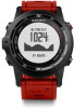
...groove on the left side of the device. 4 Align the hinged side of the charger Á with the Garmin Connect™ community. LAP Select to record a lap or a rest during an activity. Ã DOWN Select...using a standard wall outlet or a USB port on your ANT +™ sensors. 5 If the activity requires GPS, go outside, and wait while the device locates satellites. 6 Select START to prevent inadvertent key presses. 1 ... start the timer. The device is powered by a built-in lithium-ion battery that requires GPS, GPS turns on the back of day page or any data page, select UP or DOWN to...
...groove on the left side of the device. 4 Align the hinged side of the charger Á with the Garmin Connect™ community. LAP Select to record a lap or a rest during an activity. Ã DOWN Select...using a standard wall outlet or a USB port on your ANT +™ sensors. 5 If the activity requires GPS, go outside, and wait while the device locates satellites. 6 Select START to prevent inadvertent key presses. 1 ... start the timer. The device is powered by a built-in lithium-ion battery that requires GPS, GPS turns on the back of day page or any data page, select UP or DOWN to...
Quick Start Manual
Page 2
... device locates satellites. 3 Start hiking. The device records a track automatically during any activity that uses GPS, the device saves the track as a waypoint. 1 Hold DOWN. 2 Select an option: •...save the waypoint without changes, select Save. • To make changes to the waypoint, select Edit, make changes to resume tracking. 6 After you can save the run , you to back...device cannot connect to ANT + sensors while Bluetooth wireless technology is turned on -screen prompts to your Garmin® Cloud account using TracBack® or Sight 'N Go. 1 Select START > Navigate. 2 ...
... device locates satellites. 3 Start hiking. The device records a track automatically during any activity that uses GPS, the device saves the track as a waypoint. 1 Hold DOWN. 2 Select an option: •...save the waypoint without changes, select Save. • To make changes to the waypoint, select Edit, make changes to resume tracking. 6 After you can save the run , you to back...device cannot connect to ANT + sensors while Bluetooth wireless technology is turned on -screen prompts to your Garmin® Cloud account using TracBack® or Sight 'N Go. 1 Select START > Navigate. 2 ...

Quick Start Manual
Page 3
... the on-screen instructions to http: / / buy .garmin .com, or contact your Garmin dealer for more information about compatibility and purchasing optional sensors, go to select your product. Battery Life Mode 16 hours Normal GPS mode 50 hours UltraTrac GPS mode with your device. 1 If you are pairing a... heart rate monitor, put it on how much you use a sharp object to www.garmin.com/ express. 3 Prolonged exposure to Garmin Connect for comprehensive analysis. Some...
... the on-screen instructions to http: / / buy .garmin .com, or contact your Garmin dealer for more information about compatibility and purchasing optional sensors, go to select your product. Battery Life Mode 16 hours Normal GPS mode 50 hours UltraTrac GPS mode with your device. 1 If you are pairing a... heart rate monitor, put it on how much you use a sharp object to www.garmin.com/ express. 3 Prolonged exposure to Garmin Connect for comprehensive analysis. Some...


