
Owner's Manual
Page 21
... (depending on the capacity of the active track on the data card are .gpx GPS position data files, and are not used by your unit. To save the track. Basic Operation • Color-select the color of the microSD card). Track logs on the map. • Log Track to ...• Interval-records a track according to save the entire track. 3. Time creates track points after a specified distance is traveled. eTrex HC series Owner's Manual 17 Data card option (HCx units only) • Wrap When Full-the track log records over the oldest data with new data. • Record Method-distance...
... (depending on the capacity of the active track on the data card are .gpx GPS position data files, and are not used by your unit. To save the track. Basic Operation • Color-select the color of the microSD card). Track logs on the map. • Log Track to ...• Interval-records a track according to save the entire track. 3. Time creates track points after a specified distance is traveled. eTrex HC series Owner's Manual 17 Data card option (HCx units only) • Wrap When Full-the track log records over the oldest data with new data. • Record Method-distance...
Owner's Manual
Page 28
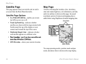
... whether each satellite appears as a different color. • New Location-use if you turn the unit on and is shown on this page. Main Pages Satellite Page This page appears when you have moved the unit more than 600 miles (1,000 km). • GPS Elevation-shows your current track toward the... Menu thereafter. Data fields Show menu Map Page with North toward the top of interest and mapping data is shown on the map display. 24 eTrex HC series Owner's Manual Map Page A built-in basemap that includes cities, interstates, state and county highways, exit information, and lake and river ...
... whether each satellite appears as a different color. • New Location-use if you turn the unit on and is shown on this page. Main Pages Satellite Page This page appears when you have moved the unit more than 600 miles (1,000 km). • GPS Elevation-shows your current track toward the... Menu thereafter. Data fields Show menu Map Page with North toward the top of interest and mapping data is shown on the map display. 24 eTrex HC series Owner's Manual Map Page A built-in basemap that includes cities, interstates, state and county highways, exit information, and lake and river ...
Owner's Manual
Page 41
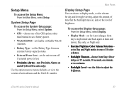
... again at dusk and dawn), Day only, or Night only. • Daytime/Nightime Color Scheme Selection- number. eTrex HC series Owner's Manual 37 Use the option menu to restore defaults, or view the version of the GPS options other than Normal to save battery power. • WAAS/EGNOS-set Enable or ...Alarms on and off (eTrex HCx units only). set in Day and Night modes to adjust the brightness. Setup Menu To access the Setup Menu: From the Main Menu, select Setup. System Setup Page To access the System Setup page: From the Setup Menu, select System. • GPS-choose one minute, or...
... again at dusk and dawn), Day only, or Night only. • Daytime/Nightime Color Scheme Selection- number. eTrex HC series Owner's Manual 37 Use the option menu to restore defaults, or view the version of the GPS options other than Normal to save battery power. • WAAS/EGNOS-set Enable or ...Alarms on and off (eTrex HCx units only). set in Day and Night modes to adjust the brightness. Setup Menu To access the Setup Menu: From the Main Menu, select Setup. System Setup Page To access the System Setup page: From the Setup Menu, select System. • GPS-choose one minute, or...
Owner's Manual
Page 49
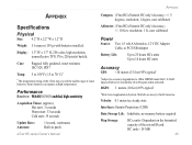
... Cable, or PC/USB Adapter Battery Life: Up to 25 hours HCx units Up to 14 hours HC units Accuracy GPS: Appendix Appendix Compass: (Vista HCx/Summit HC only) Accuracy; +/- 5 degrees, resolution; 1 degree, user calibrated Specifications Physical Size: 4.2" H x 2.2" W x 1.2" D Weight: 5.6 ounces (159 g) with batteries installed. Display: 1.3" W x 1.7" H, 256-color, high resolution, transreflective TFT(176 x 220 pixels) backlit.
... Cable, or PC/USB Adapter Battery Life: Up to 25 hours HCx units Up to 14 hours HC units Accuracy GPS: Appendix Appendix Compass: (Vista HCx/Summit HC only) Accuracy; +/- 5 degrees, resolution; 1 degree, user calibrated Specifications Physical Size: 4.2" H x 2.2" W x 1.2" D Weight: 5.6 ounces (159 g) with batteries installed. Display: 1.3" W x 1.7" H, 256-color, high resolution, transreflective TFT(176 x 220 pixels) backlit.
Quick Reference Guide
Page 1
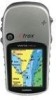
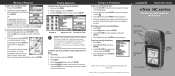
...its subsidiaries Printed in Taiwan Quick Start Guide eTrex® HC series Vista HCx, Legend HCx, Summit HC, and Venture HC GPS antenna IN/OUT (Zoom) keys ENTER/ROCKER key MENU/FIND key QUIT/ PAGE key POWER/ Backlight key Color LCD display (eTrex Vista HCx shown) (eTrex Vista HCx shown) Select a category, and press ENTER....and press ENTER. To initiate a Go To from another location using the Map Page: 1. B © Copyright 2007 Garmin Ltd. To create a new waypoint using the Find Menu: 1. Press and quickly release ENTER to begin navigation. 4. Select Recent Finds, and press ...
...its subsidiaries Printed in Taiwan Quick Start Guide eTrex® HC series Vista HCx, Legend HCx, Summit HC, and Venture HC GPS antenna IN/OUT (Zoom) keys ENTER/ROCKER key MENU/FIND key QUIT/ PAGE key POWER/ Backlight key Color LCD display (eTrex Vista HCx shown) (eTrex Vista HCx shown) Select a category, and press ENTER....and press ENTER. To initiate a Go To from another location using the Map Page: 1. B © Copyright 2007 Garmin Ltd. To create a new waypoint using the Find Menu: 1. Press and quickly release ENTER to begin navigation. 4. Select Recent Finds, and press ...

