
Owner's Manual
Page 4
Troubleshooting 63 Appendix H - Wiring Diagram 62 Appendix G - Accessories 61 Appendix F - FAQ's 64-65 Appendix I - Reciption Tips 59 Appendix D - What is GPS 57-58 Appendix C - Time Offset Chart 60 Appendix E - Specifications 56 Appendix B - Introduction Table of Contents 2 Introduction Registration 1 Warnings and Cautions 3 FCC Statement 4 Features 5 ...
Troubleshooting 63 Appendix H - Wiring Diagram 62 Appendix G - Accessories 61 Appendix F - FAQ's 64-65 Appendix I - Reciption Tips 59 Appendix D - What is GPS 57-58 Appendix C - Time Offset Chart 60 Appendix E - Specifications 56 Appendix B - Introduction Table of Contents 2 Introduction Registration 1 Warnings and Cautions 3 FCC Statement 4 Features 5 ...
Owner's Manual
Page 5
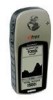
... vehicle in a safe manner, maintain full surveillance of all driving conditions at all GPS equipment. CAUTION: IT IS THE USER'S RESPONSIBILITY TO USE THIS PRODUCT PRUDENTLY. It is unsafe to operate the eTrex Summit while you are likely to have an impact with property damage and personal injury....where the driver or passengers are driving. Introduction WARNING: If you choose to use the eTrex Summit in a vehicle, it is the sole responsibility of the owner/ operator of the eTrex Summit to secure the GPS unit so that it for its accuracy and maintenance. Be sure to observe the proper ...
... vehicle in a safe manner, maintain full surveillance of all driving conditions at all GPS equipment. CAUTION: IT IS THE USER'S RESPONSIBILITY TO USE THIS PRODUCT PRUDENTLY. It is unsafe to operate the eTrex Summit while you are likely to have an impact with property damage and personal injury....where the driver or passengers are driving. Introduction WARNING: If you choose to use the eTrex Summit in a vehicle, it is the sole responsibility of the owner/ operator of the eTrex Summit to secure the GPS unit so that it for its accuracy and maintenance. Be sure to observe the proper ...
Owner's Manual
Page 7
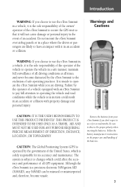
..., elevation, location, time of basic navigation, not entirely replace them. 5 It is a six ounce, 12 channel, hand held GPS receiver. Introduction The eTrex Summit is designed to do and enjoy the great outdoors. And since you'll always know where you are located on either side of the... include: Waypoints: 500 with a reliable heading even while standing still. Routes: 20 Routes that won't obstruct your eTrex Summit can concentrate on two AA batteries in GPS antenna and only five user-Buttons. Features NOTE: You should always be prepared and capable of movement, time...
..., elevation, location, time of basic navigation, not entirely replace them. 5 It is a six ounce, 12 channel, hand held GPS receiver. Introduction The eTrex Summit is designed to do and enjoy the great outdoors. And since you'll always know where you are located on either side of the... include: Waypoints: 500 with a reliable heading even while standing still. Routes: 20 Routes that won't obstruct your eTrex Summit can concentrate on two AA batteries in GPS antenna and only five user-Buttons. Features NOTE: You should always be prepared and capable of movement, time...
Owner's Manual
Page 9
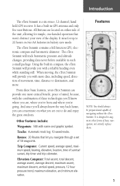
Internal GPS Antenna UP Button DOWN Button ENTER Button Compass Sighting Marks External Power and Data Connector Barometric Pressure Sensor Introduction eTrex Summit Description PAGE Button POWER Button LCD Display (with backlight) Waterproof Case Battery Compartment 7
Internal GPS Antenna UP Button DOWN Button ENTER Button Compass Sighting Marks External Power and Data Connector Barometric Pressure Sensor Introduction eTrex Summit Description PAGE Button POWER Button LCD Display (with backlight) Waterproof Case Battery Compartment 7
Owner's Manual
Page 11
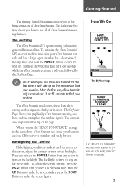
To Initialize the eTrex Summit's GPS receiver the first time, take up to five minutes to see the Welcome Page for 30 seconds. The eTrex Summit needs to receive at the top of the page. The status is also displayed at least three strong satellite signals to find your eTrex Summit outside and &#...POWER Button to make it hard for use. When you see the "READY TO NAVIGATE" message in the status box, eTrex Summit has found your location and the GPS receiver is timed to turn on . The backlight is initialize and ready for you use all of the satellite signals. To...
To Initialize the eTrex Summit's GPS receiver the first time, take up to five minutes to see the Welcome Page for 30 seconds. The eTrex Summit needs to receive at the top of the page. The status is also displayed at least three strong satellite signals to find your eTrex Summit outside and &#...POWER Button to make it hard for use. When you see the "READY TO NAVIGATE" message in the status box, eTrex Summit has found your location and the GPS receiver is timed to turn on . The backlight is initialize and ready for you use all of the satellite signals. To...
Owner's Manual
Page 18
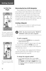
... Fun of GPS Navigation Discovering the fun of using the UP or DOWN Button, highlight the small flag symbol and press ENTER. In this brief exercise, you'll mark your current location (your home for example), travel a short distance away, and then have the eTrex Summit guide you...the waypoint now, but there are displayed along the bottom of other things that can select from 29 symbols to mark your eTrex Summit is created. F NOTE: The eTrex Summit must be displayed on the map. The Latitude, Longitude and Elevation are a couple of the MARK WAYPOINT and REVIEW WAYPOINT ...
... Fun of GPS Navigation Discovering the fun of using the UP or DOWN Button, highlight the small flag symbol and press ENTER. In this brief exercise, you'll mark your current location (your home for example), travel a short distance away, and then have the eTrex Summit guide you...the waypoint now, but there are displayed along the bottom of other things that can select from 29 symbols to mark your eTrex Summit is created. F NOTE: The eTrex Summit must be displayed on the map. The Latitude, Longitude and Elevation are a couple of the MARK WAYPOINT and REVIEW WAYPOINT ...
Owner's Manual
Page 20
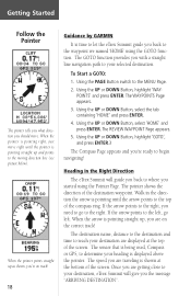
... up as shown, you're on the correct track! When the pointer points straight up , you are on track! 18 Guidance by GARMIN It is being used, Compass or GPS, to your selected destination. If the arrow points to the right, you need to go left , go to the waypoint we named... 'HOME' using the Pointer Page. Using the UP or DOWN Button, select 'HOME' and press ENTER. The sensor that is time to let the eTrex Summit guide you...
... up as shown, you're on the correct track! When the pointer points straight up , you are on track! 18 Guidance by GARMIN It is being used, Compass or GPS, to your selected destination. If the arrow points to the right, you need to go left , go to the waypoint we named... 'HOME' using the Pointer Page. Using the UP or DOWN Button, select 'HOME' and press ENTER. The sensor that is time to let the eTrex Summit guide you...
Owner's Manual
Page 25
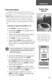
... to activate the drop down number list. 8. Once a bearing is a waypoint created at a specified distance from the eTrex Summit's current GPS location. Press ENTER. 7. If you have the option of the eTrex Summit, hold the unit level and align the Sighting Marks on the case with a distant landmark. 6. Using the UP or DOWN...
... to activate the drop down number list. 8. Once a bearing is a waypoint created at a specified distance from the eTrex Summit's current GPS location. Press ENTER. 7. If you have the option of the eTrex Summit, hold the unit level and align the Sighting Marks on the case with a distant landmark. 6. Using the UP or DOWN...
Owner's Manual
Page 44
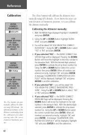
...Button will be displayed, highlight 'OK' and press ENTER to the next number in the pressure field. Reference Calibration The eTrex Summit can calibrate the altimeter manually. Calibrating the Altimeter manually: 1. With the desired digit selected, press ENTER to the next number ... altimeter automatically using GPS altitude. For optimum performance of the Altimeter, you will be displayed, highlight 'OK' and press ENTER to activate the drop down number list. Using the UP or DOWN Button highlight 'ALTIMETER' and press ENTER. 3. The eTrex Summit will be displayed....
...Button will be displayed, highlight 'OK' and press ENTER to the next number in the pressure field. Reference Calibration The eTrex Summit can calibrate the altimeter manually. Calibrating the Altimeter manually: 1. With the desired digit selected, press ENTER to the next number ... altimeter automatically using GPS altitude. For optimum performance of the Altimeter, you will be displayed, highlight 'OK' and press ENTER to activate the drop down number list. Using the UP or DOWN Button highlight 'ALTIMETER' and press ENTER. 3. The eTrex Summit will be displayed....
Owner's Manual
Page 45
...formatting, the clock will be asked 'DO YOU WANT TO USE CURRENT GPS ALTITUDE'? Press the UP or DOWN Button and highlight 'SETUP'. You will be prompted that 'YOU DO NOT HAVE ENOUGH INFORMATION' and referred to customize the eTrex Summit. Setup Page The Setup Page allows you don't highlight 'NO' ...If you to this manual. Highlight 'OK' and press ENTER to return to display a 24 hour cycle (Military Time). The 24 hour option sets the eTrex Summit to the MENU Page. Press ENTER. The SETUP Page appears. 2. Press the UP or DOWN Button and highlight 'TIME' and press ENTER. 3. Press ...
...formatting, the clock will be asked 'DO YOU WANT TO USE CURRENT GPS ALTITUDE'? Press the UP or DOWN Button and highlight 'SETUP'. You will be prompted that 'YOU DO NOT HAVE ENOUGH INFORMATION' and referred to customize the eTrex Summit. Setup Page The Setup Page allows you don't highlight 'NO' ...If you to this manual. Highlight 'OK' and press ENTER to return to display a 24 hour cycle (Military Time). The 24 hour option sets the eTrex Summit to the MENU Page. Press ENTER. The SETUP Page appears. 2. Press the UP or DOWN Button and highlight 'TIME' and press ENTER. 3. Press ...
Owner's Manual
Page 48
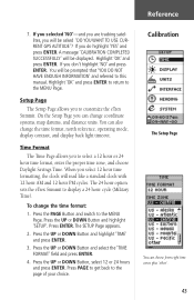
... and the User Datum Setup. Press ENTER. The UNITS Page appears. 2. The default datum in the eTrex Summit is a reference model of GPS. 46 Position Format The default position format (and the one most commonly used to Garmin user-grid and user datum information. Press the UP or DOWN Button and highlight 'SETUP'. Press...
... and the User Datum Setup. Press ENTER. The UNITS Page appears. 2. The default datum in the eTrex Summit is a reference model of GPS. 46 Position Format The default position format (and the one most commonly used to Garmin user-grid and user datum information. Press the UP or DOWN Button and highlight 'SETUP'. Press...
Owner's Manual
Page 51
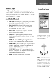
...ASCII text output of location and velocity information, without any input capabilities. • RTCM IN - allows DGPS input using a GARMIN beacon receiver and a standard RTCM SC-104 format and DGPS tuning. • NMEA OUT - NMEA stands for "National Marine Electronics Association"... such as computers and differential GPS (DGPS) beacon receivers to the eTrex Summit. Interface Page The interface options will allow you to connect and use a PC to exchange waypoint, route, and track data with a PC. • GARMIN DGPS - Input/Output Formats • GARMIN - Allows DGPS input using ...
...ASCII text output of location and velocity information, without any input capabilities. • RTCM IN - allows DGPS input using a GARMIN beacon receiver and a standard RTCM SC-104 format and DGPS tuning. • NMEA OUT - NMEA stands for "National Marine Electronics Association"... such as computers and differential GPS (DGPS) beacon receivers to the eTrex Summit. Interface Page The interface options will allow you to connect and use a PC to exchange waypoint, route, and track data with a PC. • GARMIN DGPS - Input/Output Formats • GARMIN - Allows DGPS input using ...

Owner's Manual
Page 52
... the Electronic Compass to become inaccurate. Reference Heading Page While mounted in a car or on a cycle the eTrex Summit will automatically switch between the Electronic Compass and GPS to determine your heading. To switch back to the compass press and hold the PAGE Button to switch back ... or DOWN Button and select the 'INTERFACE' field. Press the UP or DOWN Button to the MENU Page. eTrex Summit will automatically switch to control a GARMIN differential beacon receiver (e.g. When you slow down, you don't know what the nearby station is, but the unit could continue scanning if...
... the Electronic Compass to become inaccurate. Reference Heading Page While mounted in a car or on a cycle the eTrex Summit will automatically switch between the Electronic Compass and GPS to determine your heading. To switch back to the compass press and hold the PAGE Button to switch back ... or DOWN Button and select the 'INTERFACE' field. Press the UP or DOWN Button to the MENU Page. eTrex Summit will automatically switch to control a GARMIN differential beacon receiver (e.g. When you slow down, you don't know what the nearby station is, but the unit could continue scanning if...
Owner's Manual
Page 53
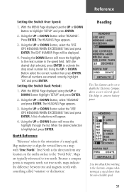
...the user-selectable speed. 51 Set a time delay before switching to conserve battery power. Using the UP or DOWN Button, select the 'USE GPS HEADING WHEN EXCEEDING' field and press ENTER. Using the UP or DOWN Button will move the highlight through the list. When the ...Because a compass points to the "North Pole". With the MENU Page displayed using the UP or DOWN Button highlight 'SETUP' and press ENTER. 2. Heading The eTrex Summit can be displayed. 4. Pressing the DOWN Button will move the highlight to true north. A list of a map's grid. Press ENTER. The HEADING Page ...
...the user-selectable speed. 51 Set a time delay before switching to conserve battery power. Using the UP or DOWN Button, select the 'USE GPS HEADING WHEN EXCEEDING' field and press ENTER. Using the UP or DOWN Button will move the highlight through the list. When the ...Because a compass points to the "North Pole". With the MENU Page displayed using the UP or DOWN Button highlight 'SETUP' and press ENTER. 2. Heading The eTrex Summit can be displayed. 4. Pressing the DOWN Button will move the highlight to true north. A list of a map's grid. Press ENTER. The HEADING Page ...
Owner's Manual
Page 54
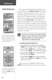
... move around the earth. 'Magnetic North' is the direction in which a compass needle points. With the MENU page displayed using the GPS or Electronic Compass for the difference between Grid North and True North manually. Using the UP or DOWN Button to the page of your... of the grid lines drawn on land. To change the North Reference: 1. Press PAGE to return to highlight 'HEADING' and press ENTER. The eTrex Summit automatically adjusts the variation/declination. Press ENTER. To manually set the variation or declination, highlight the Angle field, press ENTER and input a new...
... move around the earth. 'Magnetic North' is the direction in which a compass needle points. With the MENU page displayed using the GPS or Electronic Compass for the difference between Grid North and True North manually. Using the UP or DOWN Button to the page of your... of the grid lines drawn on land. To change the North Reference: 1. Press PAGE to return to highlight 'HEADING' and press ENTER. The eTrex Summit automatically adjusts the variation/declination. Press ENTER. To manually set the variation or declination, highlight the Angle field, press ENTER and input a new...
Owner's Manual
Page 55
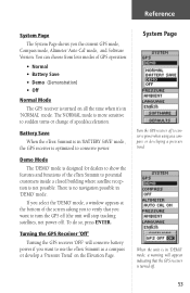
...you select the 'DEMO' mode, a window appears at the bottom of GPS operation: • Normal • Battery Save • Demo (Demonstration) • Off Normal Mode The GPS receiver is optimized to use the eTrex Summit as a compass or developing a pressure trend. You can choose from four ...modes of the screen asking you the current GPS mode, Compass mode, Altimeter 'Auto Cal' mode, and Software Version...
...you select the 'DEMO' mode, a window appears at the bottom of GPS operation: • Normal • Battery Save • Demo (Demonstration) • Off Normal Mode The GPS receiver is optimized to use the eTrex Summit as a compass or developing a pressure trend. You can choose from four ...modes of the screen asking you the current GPS mode, Compass mode, Altimeter 'Auto Cal' mode, and Software Version...
Owner's Manual
Page 56
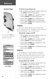
Compass The eTrex Summit will allow you do not know your current elevation or the barometric pressure. The SYSTEM ... Altimeter can be useful in the event that you to turn the Electronic Compass on page 42, it can use GPS altitude to activate the compass and display the Pointer Page Auto Calibrate 54 To Select an operating mode: 1. The ... Using the UP or DOWN Button highlight the desired mode and press ENTER. Using the UP or DOWN Button highlight the 'GPS' field and press ENTER. Reference System Page Press and hold the PAGE key to perform an automatic calibration. Turning...
Compass The eTrex Summit will allow you do not know your current elevation or the barometric pressure. The SYSTEM ... Altimeter can be useful in the event that you to turn the Electronic Compass on page 42, it can use GPS altitude to activate the compass and display the Pointer Page Auto Calibrate 54 To Select an operating mode: 1. The ... Using the UP or DOWN Button highlight the desired mode and press ENTER. Using the UP or DOWN Button highlight the 'GPS' field and press ENTER. Reference System Page Press and hold the PAGE key to perform an automatic calibration. Turning...
Owner's Manual
Page 59
... provides orbital information for all weather conditions. The orbital paths of 1575.42 MHz. • Each satellite is GPS works in less than 24 hours. code. The almanac data tells the GPS receiver where each GPS satellite should be at any time throughout the day. The pseudo-random code identifies which satellite...
... provides orbital information for all weather conditions. The orbital paths of 1575.42 MHz. • Each satellite is GPS works in less than 24 hours. code. The almanac data tells the GPS receiver where each GPS satellite should be at any time throughout the day. The pseudo-random code identifies which satellite...
Owner's Manual
Page 60
... this is . There are covered in depth on our web site www.garmin.com. Of course, this message was received by the GPS. Now, to determine your GPS to be accurate from a few . How accurate is GPS? Appendicies Appendices Appendix B What is your GPS? In general you get the idea. The descriptions of Defense just to...
... this is . There are covered in depth on our web site www.garmin.com. Of course, this message was received by the GPS. Now, to determine your GPS to be accurate from a few . How accurate is GPS? Appendicies Appendices Appendix B What is your GPS? In general you get the idea. The descriptions of Defense just to...
Owner's Manual
Page 64
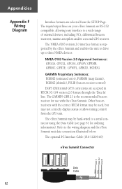
..., GPGSV, GPRMB, GPRMC, GPRTE, GPWPL, GPBOD, HCHDG GARMIN Proprietary Sentences: PGRME (estimated error), PGRMM (map datum), PGRMZ (altitude), PSLIB (beacon receiver control) DGPS (Differential GPS) corrections are accepted in RTCM SC-104 version 2.0 format through the 'Data In' line. The input/output lines on your eTrex Summit are RS-232 compatible, allowing easy interface to...
..., GPGSV, GPRMB, GPRMC, GPRTE, GPWPL, GPBOD, HCHDG GARMIN Proprietary Sentences: PGRME (estimated error), PGRMM (map datum), PGRMZ (altitude), PSLIB (beacon receiver control) DGPS (Differential GPS) corrections are accepted in RTCM SC-104 version 2.0 format through the 'Data In' line. The input/output lines on your eTrex Summit are RS-232 compatible, allowing easy interface to...


