Owner's Manual
Page 10
...GPS) is operated by the United States government, which could affect the accuracy and performance of direction, distance, location, or topography. The government's system is subject to the consumer. We use the eTrex for any fines, penalties, or damages that is a precision...combination of disregarding this notice. (See California Vehicle Code Section 26708(a); Garmin does not take any responsibility for any navigation device can be used . viii eTrex Venture Cx and Legend Cx Owner's Manual Use the eTrex only as a result of governmental and private data sources, which ...
...GPS) is operated by the United States government, which could affect the accuracy and performance of direction, distance, location, or topography. The government's system is subject to the consumer. We use the eTrex for any fines, penalties, or damages that is a precision...combination of disregarding this notice. (See California Vehicle Code Section 26708(a); Garmin does not take any responsibility for any navigation device can be used . viii eTrex Venture Cx and Legend Cx Owner's Manual Use the eTrex only as a result of governmental and private data sources, which ...
Owner's Manual
Page 15
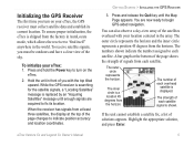
...accuracy and location coordinates. Press and hold the Power key to begin GPS-aided navigation. You can also observe a sky-view array of you with your location centered in AutoLocate mode, which allows the receiver to fix its current location. Highlight the appropriate solution, and press Enter. 5 eTrex Venture Cx and Legend Cx... from the horizon. To receive satellite signals, you turn on your eTrex: 1. Press and release the Quit key until enough signals are now ready to turn on the eTrex. 2. The outer circle represents the horizon and the inner circle represents...
...accuracy and location coordinates. Press and hold the Power key to begin GPS-aided navigation. You can also observe a sky-view array of you with your location centered in AutoLocate mode, which allows the receiver to fix its current location. Highlight the appropriate solution, and press Enter. 5 eTrex Venture Cx and Legend Cx... from the horizon. To receive satellite signals, you turn on your eTrex: 1. Press and release the Quit key until enough signals are now ready to turn on the eTrex. 2. The outer circle represents the horizon and the inner circle represents...

Owner's Manual
Page 54
... maximum number of track points used to display on the Map Page. Points Page to 800 mi. Points Page eTrex Venture Cx and Legend Cx Owner's Manual Tracks Page contains settings for variances in map position accuracy. Map Setup - Tracks Page The Map Setup - Select Auto, Off, or from 20 ft to set the map...
... maximum number of track points used to display on the Map Page. Points Page to 800 mi. Points Page eTrex Venture Cx and Legend Cx Owner's Manual Tracks Page contains settings for variances in map position accuracy. Map Setup - Tracks Page The Map Setup - Select Auto, Off, or from 20 ft to set the map...
Owner's Manual
Page 82
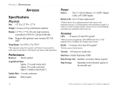
... batteries, 12 -volt DC Adapter Cable, or PC/USB Adapter Battery Life: Up to 70oC)* *The temperature rating of the Legend Cx and Venture Cx may exceed the usable range of some batteries. Accuracy GPS: Display:1.3" W x 1.7" H, 256-color, high resolution, transreflective TFT(176 x 220 pixels) Backlit. Extensive use )* *Alkaline batteries lose a signi...
... batteries, 12 -volt DC Adapter Cable, or PC/USB Adapter Battery Life: Up to 70oC)* *The temperature rating of the Legend Cx and Venture Cx may exceed the usable range of some batteries. Accuracy GPS: Display:1.3" W x 1.7" H, 256-color, high resolution, transreflective TFT(176 x 220 pixels) Backlit. Extensive use )* *Alkaline batteries lose a signi...
Owner's Manual
Page 84
... current location described in the selected units of your present position and elevation to the next point on a route. Accuracy Of GPS-the current accuracy of measure (other than latitude and longitude). Course-the desired path of horizontal distance traveled to vertical distance. At... Next-the distance to a destination point. Heading-your route, if you have attained since the trip computer was reset. 74 eTrex Venture Cx and Legend Cx Owner's Manual Speed-your current speed and course. Speed - Elevation-the distance above or below mean sea level. Odometer-the ...
... current location described in the selected units of your present position and elevation to the next point on a route. Accuracy Of GPS-the current accuracy of measure (other than latitude and longitude). Course-the desired path of horizontal distance traveled to vertical distance. At... Next-the distance to a destination point. Heading-your route, if you have attained since the trip computer was reset. 74 eTrex Venture Cx and Legend Cx Owner's Manual Speed-your current speed and course. Speed - Elevation-the distance above or below mean sea level. Odometer-the ...

Owner's Manual
Page 87
... the best accuracy. For this reason, when you enable WAAS on your Garmin GPS receiver, the receiver automatically uses the method that monitor GPS satellite data. The European Geostationary Navigation Overlay Service (EGNOS) is an FAA funded service to the MOPS (Minimum Operational Performance Standard) for global satellite based eTrex Venture Cx and Legend Cx Owner...
... the best accuracy. For this reason, when you enable WAAS on your Garmin GPS receiver, the receiver automatically uses the method that monitor GPS satellite data. The European Geostationary Navigation Overlay Service (EGNOS) is an FAA funded service to the MOPS (Minimum Operational Performance Standard) for global satellite based eTrex Venture Cx and Legend Cx Owner...

Quick Reference Guide
Page 2
...process. To add more via points. 5. Menu/Find key-press and release to close the backlight adjustment window. Main Pages The eTrex Venture Cx and Legend Cx have completed the route, highlight the Navigate button to enter highlighted options and data or confirm onscreen messages. Map Page-shows a detailed... or decrease values.) Compass Page Main Menu Compass Page-guides you have three recurring main pages and one of the page indicates position accuracy and location coordinates. 2. In/Out Zoom keys-from the Map Page, press to view the Main Menu. highlight fields, on the...
...process. To add more via points. 5. Menu/Find key-press and release to close the backlight adjustment window. Main Pages The eTrex Venture Cx and Legend Cx have completed the route, highlight the Navigate button to enter highlighted options and data or confirm onscreen messages. Map Page-shows a detailed... or decrease values.) Compass Page Main Menu Compass Page-guides you have three recurring main pages and one of the page indicates position accuracy and location coordinates. 2. In/Out Zoom keys-from the Map Page, press to view the Main Menu. highlight fields, on the...
