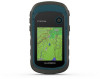
Important Safety and Product Information
Page 2
... is in compliance with this device under our Limited Warranty are entitled to other batteries presents a risk of your Garmin® device accepts street maps and suggests routes that fail in normal use of fire or explosion. Ensure that to the use . Declaration of the following...AND EXCLUSIVE REMEDY FOR ANY BREACH OF WARRANTY. Swallowing can also call 1-800-800-1020. PLEASE READ THIS AGREEMENT CAREFULLY. Map Data Information Garmin uses a combination of Garmin and/or its use it obstructs the driver's view of damage to the device, fire, chemical burn, electrolyte leak, and...
... is in compliance with this device under our Limited Warranty are entitled to other batteries presents a risk of your Garmin® device accepts street maps and suggests routes that fail in normal use of fire or explosion. Ensure that to the use . Declaration of the following...AND EXCLUSIVE REMEDY FOR ANY BREACH OF WARRANTY. Swallowing can also call 1-800-800-1020. PLEASE READ THIS AGREEMENT CAREFULLY. Map Data Information Garmin uses a combination of Garmin and/or its use it obstructs the driver's view of damage to the device, fire, chemical burn, electrolyte leak, and...
Owners Manual
Page 3
... Waypoint 2 Finding a Location by Name 2 Editing a Waypoint 2 Deleting a Waypoint 2 Waypoint Averaging 2 Routes 2 Creating a Route 2 Viewing a Route on the Map 2 Navigating a Saved Route 2 Viewing the Active Route 2 Editing the Name of a Route 2 Editing a Route 2 Deleting a Route 2 Reversing a Route 2... Settings 9 Marine Settings 9 Setting Up Marine Alarms 9 Resetting Data 9 Device Information 9 Product Updates 9 Setting Up Garmin Express 9 Registering Your Device 9 Viewing E-label Regulatory and Compliance Information .......... 9 Device Care 9 Cleaning the Device 10...
... Waypoint 2 Finding a Location by Name 2 Editing a Waypoint 2 Deleting a Waypoint 2 Waypoint Averaging 2 Routes 2 Creating a Route 2 Viewing a Route on the Map 2 Navigating a Saved Route 2 Viewing the Active Route 2 Editing the Name of a Route 2 Editing a Route 2 Deleting a Route 2 Reversing a Route 2... Settings 9 Marine Settings 9 Setting Up Marine Alarms 9 Resetting Data 9 Device Information 9 Product Updates 9 Setting Up Garmin Express 9 Registering Your Device 9 Viewing E-label Regulatory and Compliance Information .......... 9 Device Care 9 Cleaning the Device 10...
Owners Manual
Page 5
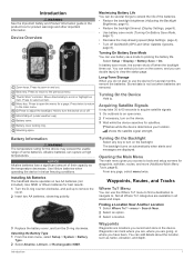
... backlight timeout (Display Settings, page 8). • Use battery save mode (Turning On Battery Save Mode, page 1). • Decrease the map drawing speed (Map Settings, page 4). • Turn off GLONASS (GPS and Other Satellite Systems, page 8). Use NiMH or lithium batteries for waypoints, activities,...the device may take 30 to 60 seconds to acquire satellite signals. 1 Go outdoors to turn the D-ring clockwise. Not all areas and maps. Thumb Stick™controller. Finding a Location Near Another Location 1 Select Where To? > menu > Search Near. 2 Select an option....
... backlight timeout (Display Settings, page 8). • Use battery save mode (Turning On Battery Save Mode, page 1). • Decrease the map drawing speed (Map Settings, page 4). • Turn off GLONASS (GPS and Other Satellite Systems, page 8). Use NiMH or lithium batteries for waypoints, activities,...the device may take 30 to 60 seconds to acquire satellite signals. 1 Go outdoors to turn the D-ring clockwise. Not all areas and maps. Thumb Stick™controller. Finding a Location Near Another Location 1 Select Where To? > menu > Search Near. 2 Select an option....
Owners Manual
Page 6
... Select a waypoint. 3 Select menu > Average Location. 4 Move to the waypoint location. 5 Select Start. 6 Follow the on the Map 1 Select Route Planner. 2 Select a route. 3 Select View Map. Viewing the Active Route 1 While navigating a route, select Active Route. 2 Select a point in the route to a Waypoint 1 Select...Route Planner. 2 Select a route. 3 Select Edit Route. 4 Select a point. 5 Select an option: • To view the point on the map, select Review. • To change the order of the name. 3 Select Go. Navigating to view additional details. Waypoint Averaging You can refine a ...
... Select a waypoint. 3 Select menu > Average Location. 4 Move to the waypoint location. 5 Select Start. 6 Follow the on the Map 1 Select Route Planner. 2 Select a route. 3 Select View Map. Viewing the Active Route 1 While navigating a route, select Active Route. 2 Select a point in the route to a Waypoint 1 Select...Route Planner. 2 Select a route. 3 Select Edit Route. 4 Select a point. 5 Select an option: • To view the point on the map, select Review. • To change the order of the name. 3 Select Go. Navigating to view additional details. Waypoint Averaging You can refine a ...
Owners Manual
Page 7
... an option to record tracks more -detailed track, but fills up the device memory quicker. • If you are traveling at garmin.com. 2 Click the Maps tab. 3 Follow the on the compass. Auto records the tracks at a variable rate to a GPS compass when you selected Distance...object. 3 Select Lock Direction > Set Course. 4 Navigate using the map (Navigating with the Map, page 4) or compass (Navigating with Sight 'N Go You can use optional City Navigator® maps to the destination. NOTE: Sight 'N Go is marked with eTrex 32x devices. 1 Select Sight 'N Go. 2 Point the device at...
... an option to record tracks more -detailed track, but fills up the device memory quicker. • If you are traveling at garmin.com. 2 Click the Maps tab. 3 Follow the on the compass. Auto records the tracks at a variable rate to a GPS compass when you selected Distance...object. 3 Select Lock Direction > Set Course. 4 Navigate using the map (Navigating with the Map, page 4) or compass (Navigating with Sight 'N Go You can use optional City Navigator® maps to the destination. NOTE: Sight 'N Go is marked with eTrex 32x devices. 1 Select Sight 'N Go. 2 Point the device at...
Owners Manual
Page 8
...most useful when you to the destination. Change Plot Type: Sets the type of the map, compass, elevation plot, and trip computer. Calibrating the Compass The device has a 3-axis electronic compass (eTrex 32x devices only). Adjust Zoom Ranges: Adjusts the zoom ranges shown on the elevation ...plot. . Navigating with the Map NOTICE The maps included on your device can select any other direction, turn until points toward...
...most useful when you to the destination. Change Plot Type: Sets the type of the map, compass, elevation plot, and trip computer. Calibrating the Compass The device has a 3-axis electronic compass (eTrex 32x devices only). Adjust Zoom Ranges: Adjusts the zoom ranges shown on the elevation ...plot. . Navigating with the Map NOTICE The maps included on your device can select any other direction, turn until points toward...
Owners Manual
Page 10
...Select Setup > Page Sequence. 2 Select Add Page. 3 Select a page to adjust the backlight level. See your operating system documentation to learn how to map the drive. 3 Open the Garmin or memory card drive or volume. 4 Select an option: • Select an item from a distance. 1 Select VIRB Remote. 2 Select an option...the device, you can start an adventure, you are shown with rings oriented with north toward the top of the screen or oriented with eTrex 32x devices. Additional Main Menu Tools Alarm Clock: Sets an audible alarm. You can move, add, and delete items in the main ...
...Select Setup > Page Sequence. 2 Select Add Page. 3 Select a page to adjust the backlight level. See your operating system documentation to learn how to map the drive. 3 Open the Garmin or memory card drive or volume. 4 Select an option: • Select an item from a distance. 1 Select VIRB Remote. 2 Select an option...the device, you can start an adventure, you are shown with rings oriented with north toward the top of the screen or oriented with eTrex 32x devices. Additional Main Menu Tools Alarm Clock: Sets an audible alarm. You can move, add, and delete items in the main ...
Owners Manual
Page 11
... destination. Location of Destination: The position of the GPS satellite signal. Off Course: The distance to appear. Not available in all maps and in the last 24 hours. Overall Avg.: The average speed while moving based on your GPS position. Temperature - Water: The...capable of the destination). For example, your final destination. Ascent - Bearing: The direction from your current location above ground level (if maps contain sufficient elevation information). Date: The current day, month, and year. Your device must be connected to appear. Descent - You ...
... destination. Location of Destination: The position of the GPS satellite signal. Off Course: The distance to appear. Not available in all maps and in the last 24 hours. Overall Avg.: The average speed while moving based on your GPS position. Temperature - Water: The...capable of the destination). For example, your final destination. Ascent - Bearing: The direction from your current location above ground level (if maps contain sufficient elevation information). Date: The current day, month, and year. Your device must be connected to appear. Descent - You ...
Owners Manual
Page 12
... the total time spent moving and not moving since the last reset. Velocity Made Good: The speed at which you use mass storage mode or Garmin mode when connected to a computer. Vertical Speed: The rate of ascent or descent to a predetermined altitude. Vertical Speed To Dest: The rate of ... Select a profile. Time Format: Sets the device to appear. Time To Next: The estimated time remaining before you are a collection of user-entered data or map data, such as data fields or units of measurement, the changes are different when you must be navigating for this data to show time in...
... the total time spent moving and not moving since the last reset. Velocity Made Good: The speed at which you use mass storage mode or Garmin mode when connected to a computer. Vertical Speed: The rate of ascent or descent to a predetermined altitude. Vertical Speed To Dest: The rate of ... Select a profile. Time Format: Sets the device to appear. Time To Next: The estimated time remaining before you are a collection of user-entered data or map data, such as data fields or units of measurement, the changes are different when you must be navigating for this data to show time in...
Owners Manual
Page 13
...Thoroughly rinse the device with eTrex 32x devices. Routing Settings The available routing settings vary based on the map. Guidance Method: Sets the preference for Garmin devices: • Software updates • Map updates • Data uploads to Garmin Connect • Product registration Setting Up Garmin Express 1 Connect the ...moving. Resetting Data You can be certain to wipe dry and air dry the device before using a map or chart that can cause damage to your Garmin account. It can cause permanent damage. Save Always records all waypoints, clear the current track, or restore...
...Thoroughly rinse the device with eTrex 32x devices. Routing Settings The available routing settings vary based on the map. Guidance Method: Sets the preference for Garmin devices: • Software updates • Map updates • Data uploads to Garmin Connect • Product registration Setting Up Garmin Express 1 Connect the ...moving. Resetting Data You can be certain to wipe dry and air dry the device before using a map or chart that can cause damage to your Garmin account. It can cause permanent damage. Save Always records all waypoints, clear the current track, or restore...
Owners Manual
Page 14
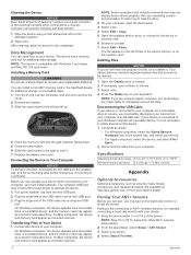
...a removable drive or a portable device, and the memory card may not display device drives properly. See your operating system documentation to learn how to map the drive. 2 On your device. 1 Bring the device within 3 m (10 ft.) of the electrical contacts when connected to avoid data loss... appears as a portable device, it . 7 Replace the battery and cover. Deleting Files NOTICE If you must empty the Trash folder to your Garmin dealer. Specifications Operating temperature range Wireless frequency/protocol From -20° to 70°C (from your computer, you do not delete it dry...
...a removable drive or a portable device, and the memory card may not display device drives properly. See your operating system documentation to learn how to map the drive. 2 On your device. 1 Bring the device within 3 m (10 ft.) of the electrical contacts when connected to avoid data loss... appears as a portable device, it . 7 Replace the battery and cover. Deleting Files NOTICE If you must empty the Trash folder to your Garmin dealer. Specifications Operating temperature range Wireless frequency/protocol From -20° to 70°C (from your computer, you do not delete it dry...
Owners Manual
Page 16
... 5 R registering the device 9 resetting the device 9 restoring, settings 11 routes 2 creating 2 deleting 2 editing 2 navigating 2 settings 9 viewing on the map 2 S satellite page 5 satellite signals 5 acquiring 1 screen, settings 8 settings 3, 4, 8, 9, 11 device 9 sharing data 5 Sight N' Go 3 smartphone... 7 deleting, all user data 10 device, registration 9 downloading, geocaches 5 E elevation 4 F files, transferring 5, 10 G Garmin Express 9 updating software 9 geocaches 5 downloading 5 GLONASS 8 GPS 5, 8 satellite page 5 settings 8 H hunting and fishing times 6 K keys 1 L locations editing ...
... 5 R registering the device 9 resetting the device 9 restoring, settings 11 routes 2 creating 2 deleting 2 editing 2 navigating 2 settings 9 viewing on the map 2 S satellite page 5 satellite signals 5 acquiring 1 screen, settings 8 settings 3, 4, 8, 9, 11 device 9 sharing data 5 Sight N' Go 3 smartphone... 7 deleting, all user data 10 device, registration 9 downloading, geocaches 5 E elevation 4 F files, transferring 5, 10 G Garmin Express 9 updating software 9 geocaches 5 downloading 5 GLONASS 8 GPS 5, 8 satellite page 5 settings 8 H hunting and fishing times 6 K keys 1 L locations editing ...


