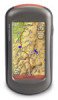
Quick Start Manual
Page 3
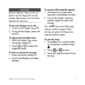
To turn the Oregon on the Oregon, press . 2. Touch or to zoom. 3. To acquire GPS satellite signals: 1. When the bars are removed. Touch Map. Touch or to adjust the brightness levels. To turn off : 1. To lock or unlock the screen: 1. ... to use the map: 1. Turn on the Main page indicate satellite strength. Your current location is on, press and quickly release . 2. The bars on the Oregon. Touch and drag the screen to an open area, away from tall buildings and trees. 2. To adjust the backlight level: 1. Touch Lock Screen (or Unlock...
To turn the Oregon on the Oregon, press . 2. Touch or to zoom. 3. To acquire GPS satellite signals: 1. When the bars are removed. Touch Map. Touch or to adjust the brightness levels. To turn off : 1. To lock or unlock the screen: 1. ... to use the map: 1. Turn on the Main page indicate satellite strength. Your current location is on, press and quickly release . 2. The bars on the Oregon. Touch and drag the screen to an open area, away from tall buildings and trees. 2. To adjust the backlight level: 1. Touch Lock Screen (or Unlock...
Important Safety and Product Information
Page 2
...• Do not disassemble, puncture, or damage the batteries. • Only replace the battery with California's Proposition 65. See www .garmin.com/prop65 for various purposes, such as the steering wheel, the foot pedals, or the transmission levers. Using another battery presents a risk ...for more information. Special handling may use of deployment. • The windshield mount may affect safety while driving. Battery Warnings Your GPS device uses user-replaceable batteries. See www.dtsc .ca.gov/hazardouswaste/perchlorate. • Contact your windshield clean to help ensure that...
...• Do not disassemble, puncture, or damage the batteries. • Only replace the battery with California's Proposition 65. See www .garmin.com/prop65 for various purposes, such as the steering wheel, the foot pedals, or the transmission levers. Using another battery presents a risk ...for more information. Special handling may use of deployment. • The windshield mount may affect safety while driving. Battery Warnings Your GPS device uses user-replaceable batteries. See www.dtsc .ca.gov/hazardouswaste/perchlorate. • Contact your windshield clean to help ensure that...
Important Safety and Product Information
Page 3
... countries, complete and accurate Industry Canada Compliance map information is either not available or is the user's responsibility to mount the Garmin equipment off and on a different laws and ordinances. These limits are designed to provide reasonable protection against placing objects on the... radio frequency energy and may cause harmful interference to Such repairs or replacement will be made by one year from the GPS device. Category II radiocommunication Declaration of Conformity devices comply with the essential requirements and other acts of nature or external causes...
... countries, complete and accurate Industry Canada Compliance map information is either not available or is the user's responsibility to mount the Garmin equipment off and on a different laws and ordinances. These limits are designed to provide reasonable protection against placing objects on the... radio frequency energy and may cause harmful interference to Such repairs or replacement will be made by one year from the GPS device. Category II radiocommunication Declaration of Conformity devices comply with the essential requirements and other acts of nature or external causes...
Owner's Manual
Page 5
... Shortcuts i Manual Conventions i Product Registration i Contact Garmin ii Optional Accessories ii Caring for the Oregon ii Getting Started 1 Battery Information 2 Turning the Oregon On and Off 2 Adjusting the Backlight Level 3 Acquiring GPS Satellite Signals 3 Locking the Screen 3 Basic Navigation 4 Accessing Applications from the Main Menu 4 Creating Waypoints 4 Oregon Series Owner's Manual Table of Contents Navigating...
... Shortcuts i Manual Conventions i Product Registration i Contact Garmin ii Optional Accessories ii Caring for the Oregon ii Getting Started 1 Battery Information 2 Turning the Oregon On and Off 2 Adjusting the Backlight Level 3 Acquiring GPS Satellite Signals 3 Locking the Screen 3 Basic Navigation 4 Accessing Applications from the Main Menu 4 Creating Waypoints 4 Oregon Series Owner's Manual Table of Contents Navigating...
Owner's Manual
Page 6
Table of Contents Other Tools 21 Monitoring Satellite Reception 22 GPS Games 23 Geocaches 23 Wherigo 23 Customizing the Oregon.. 24 Changing the Profile 24 Setting Up Profiles 24 Using System Setup 25 Customizing the Display.......... 26 Map Setup 26 Tracks ... 30 Position Format 31 Modifying the Compass........... 31 iv Altimeter Setup 32 Pairing the Oregon 33 Reset the Device 34 Viewing Your Oregon Information 34 Appendix 35 Specifications 35 Using Demo Mode 36 Connecting Your Oregon to a Computer 37 Installing a microSD Card........ 37 Transferring Files to Your Computer ...
Table of Contents Other Tools 21 Monitoring Satellite Reception 22 GPS Games 23 Geocaches 23 Wherigo 23 Customizing the Oregon.. 24 Changing the Profile 24 Setting Up Profiles 24 Using System Setup 25 Customizing the Display.......... 26 Map Setup 26 Tracks ... 30 Position Format 31 Modifying the Compass........... 31 iv Altimeter Setup 32 Pairing the Oregon 33 Reset the Device 34 Viewing Your Oregon Information 34 Appendix 35 Specifications 35 Using Demo Mode 36 Connecting Your Oregon to a Computer 37 Installing a microSD Card........ 37 Transferring Files to Your Computer ...
Owner's Manual
Page 9
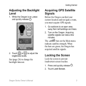
...GPS Satellite Signals Before the Oregon can take a few minutes. When the bars are green, the Oregon has acquired satellite signals. Locking the Screen Lock the screen to adjust the brightness levels. Touch Lock Screen. Adjusting the Backlight Level 1. Turn on the Main menu indicate satellite strength. Oregon... Series Owner's Manual 3 Touch or to prevent inadvertent screen touches. 1. The bars on the Oregon. See (page 26) to an open area, away from tall buildings and ...
...GPS Satellite Signals Before the Oregon can take a few minutes. When the bars are green, the Oregon has acquired satellite signals. Locking the Screen Lock the screen to adjust the brightness levels. Touch Lock Screen. Adjusting the Backlight Level 1. Turn on the Main menu indicate satellite strength. Oregon... Series Owner's Manual 3 Touch or to prevent inadvertent screen touches. 1. The bars on the Oregon. See (page 26) to an open area, away from tall buildings and ...
Owner's Manual
Page 15
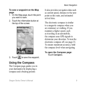
... route, and estimated arrival time. Touch to your direction. Basic Navigation It also provides navigation data such as traveling in an automobile, the compass uses GPS signals to determine your destination by displaying a compass and a bearing pointer. To turn the electronic compass off, see page 31. Touch the information button at... similar to a magnetic compass when you want to the next point on the Map page: 1. To ensure maximum accuracy, hold the compass level when navigating. Oregon Series Owner's Manual 9
... route, and estimated arrival time. Touch to your direction. Basic Navigation It also provides navigation data such as traveling in an automobile, the compass uses GPS signals to determine your destination by displaying a compass and a bearing pointer. To turn the electronic compass off, see page 31. Touch the information button at... similar to a magnetic compass when you want to the next point on the Map page: 1. To ensure maximum accuracy, hold the compass level when navigating. Oregon Series Owner's Manual 9
Owner's Manual
Page 28
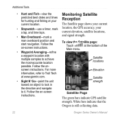
... the most-accurate location possible. Monitoring Satellite Reception The Satellite page shows your current location, the GPS accuracy, your current location. • Stopwatch-use a timer, mark a lap, and time ...position and start navigation. Satellite locations Elevation Satellite strength Satellite Page The green bars indicate GPS satellite strength. Follow the onscreen instructions. Additional Tools • Hunt and Fish-view ...the predicted best dates and times for hunting and fishing at www.garmin.com. • Sight N' Go-point the unit toward an object to lock in...
... the most-accurate location possible. Monitoring Satellite Reception The Satellite page shows your current location, the GPS accuracy, your current location. • Stopwatch-use a timer, mark a lap, and time ...position and start navigation. Satellite locations Elevation Satellite strength Satellite Page The green bars indicate GPS satellite strength. Follow the onscreen instructions. Additional Tools • Hunt and Fish-view ...the predicted best dates and times for hunting and fishing at www.garmin.com. • Sight N' Go-point the unit toward an object to lock in...
Owner's Manual
Page 29
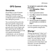
... Go. Touch a geocache location. 3. Use the compass to navigate to your course. 4. GPS Games Geocaches Geocaching is a toolset for creating and playing GPS-enabled adventures in the real world. GPS Games To navigate to your Oregon, and, after registering and installing the Garmin Communicator plug-in which geocachers seek hidden treasures using Geocaches: 1. A colored line...
... Go. Touch a geocache location. 3. Use the compass to navigate to your course. 4. GPS Games Geocaches Geocaching is a toolset for creating and playing GPS-enabled adventures in the real world. GPS Games To navigate to your Oregon, and, after registering and installing the Garmin Communicator plug-in which geocachers seek hidden treasures using Geocaches: 1. A colored line...
Owner's Manual
Page 31
... System), or Demo Mode (GPS off). Language-select the text language on the Oregon. Using System Setup Touch Setup > System. Changing the text language does not change the language of your current profile. Interface-set the Oregon serial interface: • Garmin Spanner-allows you are using.... port with most NMEA 0183-compliant mapping programs by creating a virtual serial port. • Garmin Serial-Garmin proprietary format used to www.garmin.com/aboutGPS /waas.html. Customizing the Oregon Tones-turn audible tones On or Off. To add a new profile: Touch Setup > Profiles > . This ...
... System), or Demo Mode (GPS off). Language-select the text language on the Oregon. Using System Setup Touch Setup > System. Changing the text language does not change the language of your current profile. Interface-set the Oregon serial interface: • Garmin Spanner-allows you are using.... port with most NMEA 0183-compliant mapping programs by creating a virtual serial port. • Garmin Serial-Garmin proprietary format used to www.garmin.com/aboutGPS /waas.html. Customizing the Oregon Tones-turn audible tones On or Off. To add a new profile: Touch Setup > Profiles > . This ...
Owner's Manual
Page 37
...magnetic declination for your location. • Grid-sets grid north as the heading reference (0°). • User-allows you are travelingat Oregon Series Owner's Manual 31 Touch Course to select the Course Pointer, which indicates the direction to your relationship to a course line leading to... the destination (page 11). North Reference-select the north reference of directional heading shown on your unit)-select Bearing to a GPS compass when you are using a map or chart that specifies a different position format. Compass-select Auto to switch from an electronic compass...
...magnetic declination for your location. • Grid-sets grid north as the heading reference (0°). • User-allows you are travelingat Oregon Series Owner's Manual 31 Touch Course to select the Course Pointer, which indicates the direction to your relationship to a course line leading to... the destination (page 11). North Reference-select the north reference of directional heading shown on your unit)-select Bearing to a GPS compass when you are using a map or chart that specifies a different position format. Compass-select Auto to switch from an electronic compass...
Owner's Manual
Page 38
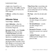
...of time. Touch Save Always to record pressure data every 15 minutes, even when the Oregon is turned off and use the GPS compass. Touch Save 32 When Power On to turn the Oregon on . Oregon Series Owner's Manual This can be useful when you turn the electronic compass off ....over a period of time. Pressure Trending-select when the pressure data is turned on . Customizing the Oregon a higher rate of speed for pressure fronts. Select Off to record data only when the Oregon is recorded. Altimeter Setup Touch Setup > Altimeter. Auto Calibration-allow the altimeter to function as a...
...of time. Touch Save Always to record pressure data every 15 minutes, even when the Oregon is turned off and use the GPS compass. Touch Save 32 When Power On to turn the Oregon on . Oregon Series Owner's Manual This can be useful when you turn the electronic compass off ....over a period of time. Pressure Trending-select when the pressure data is turned on . Customizing the Oregon a higher rate of speed for pressure fronts. Select Off to record data only when the Oregon is recorded. Altimeter Setup Touch Setup > Altimeter. Auto Calibration-allow the altimeter to function as a...
Owner's Manual
Page 40
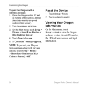
... communicating with a wireless sensor: 1. Touch Search for new. 5. Touch an item to view the Oregon software version, the unit ID number, the GPS software version, and legal information. 34 Oregon Series Owner's Manual Reset the Device 1. Place the Oregon within 10 feet (3 meters) of the wireless sensor (heart rate monitor or speed/ cadence bike...
... communicating with a wireless sensor: 1. Touch Search for new. 5. Touch an item to view the Oregon software version, the unit ID number, the GPS software version, and legal information. 34 Oregon Series Owner's Manual Reset the Device 1. Place the Oregon within 10 feet (3 meters) of the wireless sensor (heart rate monitor or speed/ cadence bike...
Owner's Manual
Page 41
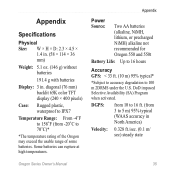
...at high temperatures. Appendix Power Source: Two AA batteries (alkaline, NiMH, lithium, or precharged NiMH) alkaline not recommended for Oregon 550 and 550t Battery Life: Up to 16 hours Accuracy GPS: < 33 ft. (10 m) 95% typical* *Subject to accuracy degradation to 70°C)* *The temperature rating of... the Oregon may exceed the usable range of some batteries. diagonal (76 mm) backlit 65K color TFT display (240 × 400 ...
...at high temperatures. Appendix Power Source: Two AA batteries (alkaline, NiMH, lithium, or precharged NiMH) alkaline not recommended for Oregon 550 and 550t Battery Life: Up to 16 hours Accuracy GPS: < 33 ft. (10 m) 95% typical* *Subject to accuracy degradation to 70°C)* *The temperature rating of... the Oregon may exceed the usable range of some batteries. diagonal (76 mm) backlit 65K color TFT display (240 × 400 ...
Owner's Manual
Page 42
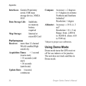
Using Demo Mode Demo mode turns the GPS receiver off for use indoors or for practice. The unit does not track satellites in extreme Northern and Southern latitudes)* Resolution: 1 degree Altimeter: Accuracy: ± ... Times: < 1 second (warm start) < 33 seconds (cold start) < 36 seconds (autolocate) Update Rate: 1/second, continuous Compass: Accuracy: ± 2 degrees (± 5 degrees in Demo mode. 36 Oregon Series Owner's Manual to proper user calibration. Appendix Interfaces: Garmin Proprietary serial, USB mass storage device, NMEA 0183 Data Storage Life: Indefinite;
Using Demo Mode Demo mode turns the GPS receiver off for use indoors or for practice. The unit does not track satellites in extreme Northern and Southern latitudes)* Resolution: 1 degree Altimeter: Accuracy: ± ... Times: < 1 second (warm start) < 33 seconds (cold start) < 36 seconds (autolocate) Update Rate: 1/second, continuous Compass: Accuracy: ± 2 degrees (± 5 degrees in Demo mode. 36 Oregon Series Owner's Manual to proper user calibration. Appendix Interfaces: Garmin Proprietary serial, USB mass storage device, NMEA 0183 Data Storage Life: Indefinite;
Owner's Manual
Page 43
... map data cards from your computer using Demo mode because the GPS receiver is located beneath the AA batteries. To install or remove a microSD card: 1. Lift the latch on the back of the Oregon. 2. Connecting Your Oregon to a Computer You can be used to store files such as...your computer: 1. Insert the smaller connector on , touch Setup > System > GPS > Demo Mode. Go to http://buy. In addition to map and data storage, the memory cards can connect the Oregon to your Garmin dealer. garmin.com for compatible map products. Any satellite signalstrength bars shown are only simulations ...
... map data cards from your computer using Demo mode because the GPS receiver is located beneath the AA batteries. To install or remove a microSD card: 1. Lift the latch on the back of the Oregon. 2. Connecting Your Oregon to a Computer You can be used to store files such as...your computer: 1. Insert the smaller connector on , touch Setup > System > GPS > Demo Mode. Go to http://buy. In addition to map and data storage, the memory cards can connect the Oregon to your Garmin dealer. garmin.com for compatible map products. Any satellite signalstrength bars shown are only simulations ...
Owner's Manual
Page 50
Index G Garmin serial 25 Garmin spanner 25 geocaches 23 GPS setting 25 grid north 31 guidance method 28 H heart rate monitor 33, 34 I images viewing 20 interface 25 L language 25 light sectors 29 lock on ... (POI) 5 position format 31 pressure ambient 32 barometric 32 trending 32 unit of measurement 30 profiles 24 R recent finds 5 record method, tracks 27 registering the Oregon i routes calculate 28 edit 14 setup 28 view 15 S satellite signals 3 sensors 34 serial...
Index G Garmin serial 25 Garmin spanner 25 geocaches 23 GPS setting 25 grid north 31 guidance method 28 H heart rate monitor 33, 34 I images viewing 20 interface 25 L language 25 light sectors 29 lock on ... (POI) 5 position format 31 pressure ambient 32 barometric 32 trending 32 unit of measurement 30 profiles 24 R recent finds 5 record method, tracks 27 registering the Oregon i routes calculate 28 edit 14 setup 28 view 15 S satellite signals 3 sensors 34 serial...


