Owner's Manual
Page 7
.... If you have any NAVAID can be misused or misinterpreted and, therefore, become unsafe. GPSmap 60 Introduction Warnings and Precautions vii Although the Garmin GPSmap 60 is either not available or prohibitively expensive. MAP DATA INFORMATION: One of the goals of Garmin is to provide customers with California's Proposition 65. This Notice is available to us at...
.... If you have any NAVAID can be misused or misinterpreted and, therefore, become unsafe. GPSmap 60 Introduction Warnings and Precautions vii Although the Garmin GPSmap 60 is either not available or prohibitively expensive. MAP DATA INFORMATION: One of the goals of Garmin is to provide customers with California's Proposition 65. This Notice is available to us at...
Owner's Manual
Page 9
...46 Tones Setup 48 Page Sequence Setup 48 Map Setup 49 Routing Setup 52 Geocache Setup 53 Marine Setup 53 Time Setup 54 Units Setup 54 Heading Setup 55 Welcome Page Setup 55 ....... GPSmap 60 Introduction Section 1: Introduction i-viii Preface i ...Information iii Warnings and Precautions iv-vi Table of Contents Section 3: GPS Navigation 8-56 The Map Page 8 .. Initialization 4 ... The Satellite Page 4.. Using Waypoints 17 .. Unit Features 3... Navigating with the GPSmap 60 5 . The Main Page Features 7 Table of Contents vii-viii Section 2: Getting Started 1-7...
...46 Tones Setup 48 Page Sequence Setup 48 Map Setup 49 Routing Setup 52 Geocache Setup 53 Marine Setup 53 Time Setup 54 Units Setup 54 Heading Setup 55 Welcome Page Setup 55 ....... GPSmap 60 Introduction Section 1: Introduction i-viii Preface i ...Information iii Warnings and Precautions iv-vi Table of Contents Section 3: GPS Navigation 8-56 The Map Page 8 .. Initialization 4 ... The Satellite Page 4.. Using Waypoints 17 .. Unit Features 3... Navigating with the GPSmap 60 5 . The Main Page Features 7 Table of Contents vii-viii Section 2: Getting Started 1-7...
Owner's Manual
Page 10
Specifications 68 Data Field Definitions 70 Connecting the GPSmap 60 to a Computer 74 . Index 80 ... Non-Enhanced Game 65 Section 5: Appendices 66-82 Accessories 66 . WAAS and DGPS 78W iring Diagram 79 ..... Downloading MapSource Map Data 75 UTC Offset Chart 76 . Limited Warranty 82 x GPS Enhanced Games 62 . Map Datums and Position Formats 77 . GPSmap 60 Introduction Table of Contents Section 4: GPS Features 57-65 Calendar 57 Alarm Clock 58 Calculator 58 Stopwatch 59 Sun and Moon Tables 60H unt and Fish Tables 61....
Specifications 68 Data Field Definitions 70 Connecting the GPSmap 60 to a Computer 74 . Index 80 ... Non-Enhanced Game 65 Section 5: Appendices 66-82 Accessories 66 . WAAS and DGPS 78W iring Diagram 79 ..... Downloading MapSource Map Data 75 UTC Offset Chart 76 . Limited Warranty 82 x GPS Enhanced Games 62 . Map Datums and Position Formats 77 . GPSmap 60 Introduction Table of Contents Section 4: GPS Features 57-65 Calendar 57 Alarm Clock 58 Calculator 58 Stopwatch 59 Sun and Moon Tables 60H unt and Fish Tables 61....
Owner's Manual
Page 12
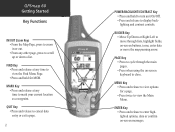
...• Press and release to cancel data entry or exit a page. 2 GPSmap 60 IN FIND OUT PAGE MARK QUIT MENU ENTER POWER/BACKLIGHT/CONTRAST Key • Press...and release to enter highlighted options, data or confirm on -screen buttons, icons, enter data or move the map panning arrow. ROCKER Key • Move Up/Down or Right/Left to move through the main pages. &#...unit On/Off. • Press and release to display backlighting and contrast controls. GPSmap 60 Getting Started Key Functions IN/OUT Zoom Keys • From the Map Page, press to zoom in or out. • From any time to mark...
...• Press and release to cancel data entry or exit a page. 2 GPSmap 60 IN FIND OUT PAGE MARK QUIT MENU ENTER POWER/BACKLIGHT/CONTRAST Key • Press...and release to enter highlighted options, data or confirm on -screen buttons, icons, enter data or move the map panning arrow. ROCKER Key • Move Up/Down or Right/Left to move through the main pages. &#...unit On/Off. • Press and release to display backlighting and contrast controls. GPSmap 60 Getting Started Key Functions IN/OUT Zoom Keys • From the Map Page, press to zoom in or out. • From any time to mark...
Owner's Manual
Page 14
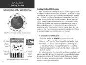
..."Locating Satellites" message followed by the Satellite Page. 3. You will also see a sky view array of the satellites overhead with your GPSmap 60: 1. The outer circle represents the horizon and the inner circle a position 45o from each satellite. A bar graph displays the strength of...than 600 miles from the options menu, then you use the Map Page to determine your position. GPSmap 60 Getting Started Initialization & the Satellite Page The GPSmap 60 locates satellites above your general location so the GPSmap 60 can use your original location, it takes only seconds to minutes...
..."Locating Satellites" message followed by the Satellite Page. 3. You will also see a sky view array of the satellites overhead with your GPSmap 60: 1. The outer circle represents the horizon and the inner circle a position 45o from each satellite. A bar graph displays the strength of...than 600 miles from the options menu, then you use the Map Page to determine your position. GPSmap 60 Getting Started Initialization & the Satellite Page The GPSmap 60 locates satellites above your general location so the GPSmap 60 can use your original location, it takes only seconds to minutes...

Owner's Manual
Page 15
... by three of navigating to avoid objects that has been stored (logged) in the GPSmap 60. Go To - GPSmap 60 Getting Started Initialization & The Satellite Page Map Item Details Position Arrow Map Scale Map Pointer Map Page with Current Position Arrow Navigating with a route line, and leaves a trail ... that are three methods of the Main Pages: The Map Page graphically shows you, your current location, marks your GPSmap 60, the solution could be as simple as moving slightly to a destination when using the GPSmap 60, each graphically displayed on Tracks, Routes and Waypoints for...
... by three of navigating to avoid objects that has been stored (logged) in the GPSmap 60. Go To - GPSmap 60 Getting Started Initialization & The Satellite Page Map Item Details Position Arrow Map Scale Map Pointer Map Page with Current Position Arrow Navigating with a route line, and leaves a trail ... that are three methods of the Main Pages: The Map Page graphically shows you, your current location, marks your GPSmap 60, the solution could be as simple as moving slightly to a destination when using the GPSmap 60, each graphically displayed on Tracks, Routes and Waypoints for...
Owner's Manual
Page 16
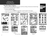
... On" Page Satellite Page Trip Computer Page Map Page Satellite Page Options 6 Trip Computer Page Options Map Page Options Compass Page Main Menu Compass Page Options There are no Options at the Menu level GPSmap 60 Getting Started The Main Page Sequence Whenr you turn on the GPSmap 60, you can see the Power On Page...
... On" Page Satellite Page Trip Computer Page Map Page Satellite Page Options 6 Trip Computer Page Options Map Page Options Compass Page Main Menu Compass Page Options There are no Options at the Menu level GPSmap 60 Getting Started The Main Page Sequence Whenr you turn on the GPSmap 60, you can see the Power On Page...
Owner's Manual
Page 18
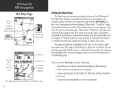
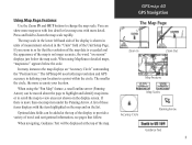
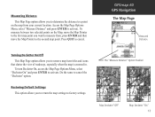
... higher level of travel), a north reference arrow appears at sunrise and sunset. GPSmap 60 GPS Navigation The Map Page "North Up" Mode with Map oriented with North at the top The Map Scale The Map Page Position Arrow "Track Up" Mode North Orientation Arrow Data Fields Guidance Text ...with the unit (i.e. The map display can use the Map Page to do the following a Route displayed on the map. • Customize the map display to "Night" mode for easier viewing in dim light. residential streets, parks, etc.) because Garmin MapSource® detailed mapping data has been downloaded ...
... higher level of travel), a north reference arrow appears at sunrise and sunset. GPSmap 60 GPS Navigation The Map Page "North Up" Mode with Map oriented with North at the top The Map Scale The Map Page Position Arrow "Track Up" Mode North Orientation Arrow Data Fields Guidance Text ...with the unit (i.e. The map display can use the Map Page to do the following a Route displayed on the map. • Customize the map display to "Night" mode for easier viewing in dim light. residential streets, parks, etc.) because Garmin MapSource® detailed mapping data has been downloaded ...
Owner's Manual
Page 19
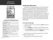
... location. The smaller the circle, the more than one map item under the Panning Arrow. When using MapSource detailed maps, "mapsource" appears below the map scale. Press and hold to change the map scale. The GPSmap 60 uses both map resolution and GPS accuracy in so far that follow. If...;elds can show more map area with less detail or less map area with the item highlighted on the map and on the display screen. GPSmap 60 GPS Navigation The Map Page Zoom In Zoom Out Map Features Map Scales Accuracy Circle Panning Arrow Guidance Text 9 Using Map Page Features Use the ...
... location. The smaller the circle, the more than one map item under the Panning Arrow. When using MapSource detailed maps, "mapsource" appears below the map scale. Press and hold to change the map scale. The GPSmap 60 uses both map resolution and GPS accuracy in so far that follow. If...;elds can show more map area with less detail or less map area with the item highlighted on the map and on the display screen. GPSmap 60 GPS Navigation The Map Page Zoom In Zoom Out Map Features Map Scales Accuracy Circle Panning Arrow Guidance Text 9 Using Map Page Features Use the ...
Owner's Manual
Page 20
... the MENU key to display a variety of navigation information you to the factory default settings. GPSmap 60 GPS Navigation The Map Page The Map Page Options Menu A Quick Look at the top of roads and other locations on the map page. Recalculate - Recalculates a route and is disabled when there is no active navigation. Change Data...
... the MENU key to display a variety of navigation information you to the factory default settings. GPSmap 60 GPS Navigation The Map Page The Map Page Options Menu A Quick Look at the top of roads and other locations on the map page. Recalculate - Recalculates a route and is disabled when there is no active navigation. Change Data...
Owner's Manual
Page 21
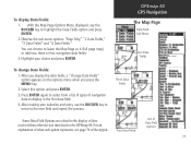
Observe the sub-menu options: "Map Only," "2 Data Fields," "3 Data Fields" and "4 Data Fields." Press ENTER again to select from other devices interfaced to the GPSmap 60. You can choose to display in the first data field. 4. Highlight your selection and entry, use the ROCKER key to ... Options Menu displayed, use the ROCKER key to move to highlight the Data Fields option and press ENTER. 2. GPSmap 60 GPS Navigation The Map Page Data Field Sub-Menu Two Data Fields To change Data Fields: 1. After making your choice and press ENTER. Select this option and ...
Observe the sub-menu options: "Map Only," "2 Data Fields," "3 Data Fields" and "4 Data Fields." Press ENTER again to select from other devices interfaced to the GPSmap 60. You can choose to display in the first data field. 4. Highlight your selection and entry, use the ROCKER key to ... Options Menu displayed, use the ROCKER key to move to highlight the Data Fields option and press ENTER. 2. GPSmap 60 GPS Navigation The Map Page Data Field Sub-Menu Two Data Fields To change Data Fields: 1. After making your choice and press ENTER. Select this option and ...
Owner's Manual
Page 22
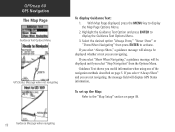
.... If you select "Always Show," a guidance message will display GPS Status information, To set up the Map: Refer to display the Guidance Text Options Menu. 3. Guidance Text shows you are navigating. GPSmap 60 GPS Navigation The Map Page Guidance Text Options Menu GPS Status Message when not navigating To display Guidance Text: 1. If you... page 49. 12 Guidance Message when navigating Select the desired option "Always Show," "Never Show" or "Show When Navigating" then press ENTER to display the Map Page Options Menu. 2. Highlight the Guidance Text Option and press ENTER to the...
.... If you select "Always Show," a guidance message will display GPS Status information, To set up the Map: Refer to display the Guidance Text Options Menu. 3. Guidance Text shows you are navigating. GPSmap 60 GPS Navigation The Map Page Guidance Text Options Menu GPS Status Message when not navigating To display Guidance Text: 1. If you... page 49. 12 Guidance Message when navigating Select the desired option "Always Show," "Never Show" or "Show When Navigating" then press ENTER to display the Map Page Options Menu. 2. Highlight the Guidance Text Option and press ENTER to the...
Owner's Manual
Page 23
To measure between two selected points on the map from , press ENTER and then move the Map Pointer to the second map point. GPSmap 60 GPS Navigation The Map Page Measured Distance Turning Declutter On/Off This Map Page option allows you to return the map settings to factory settings. Restoring Default Settings This option allows you to remove...
To measure between two selected points on the map from , press ENTER and then move the Map Pointer to the second map point. GPSmap 60 GPS Navigation The Map Page Measured Distance Turning Declutter On/Off This Map Page option allows you to return the map settings to factory settings. Restoring Default Settings This option allows you to remove...
Owner's Manual
Page 24
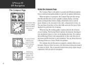
... as current speed, distance to provide navigation information. Using the Compass Page The Compass Page is especially helpful when using a paper map in each from three or four data fields and select the type of travel and the distance you oriented in progress, the Compass... to display information such as a magnetic compass when you are moving , the rotating graphic compass indicates the direction you are heading. GPSmap 60 GPS Navigation The Compass Page Compass Page The Compass Ring moves to indicate North orientation when you are stationary. However when you move,...
... as current speed, distance to provide navigation information. Using the Compass Page The Compass Page is especially helpful when using a paper map in each from three or four data fields and select the type of travel and the distance you oriented in progress, the Compass... to display information such as a magnetic compass when you are moving , the rotating graphic compass indicates the direction you are heading. GPSmap 60 GPS Navigation The Compass Page Compass Page The Compass Ring moves to indicate North orientation when you are stationary. However when you move,...
Owner's Manual
Page 26
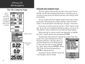
GPSmap 60 GPS Navigation The Trip Computer Page Select "Change Data Fields" or press the ROCKER key to highlight a field you want to view signifi... is useful when navigating long distances. Before each trip, a "Reset" option is done in the same manner as for the data fields on the Map Page. (See page 11 for navigation. This page allows you want to meet your personal requirements. Selecting the "Restore Defaults" option will return the page...
GPSmap 60 GPS Navigation The Trip Computer Page Select "Change Data Fields" or press the ROCKER key to highlight a field you want to view signifi... is useful when navigating long distances. Before each trip, a "Reset" option is done in the same manner as for the data fields on the Map Page. (See page 11 for navigation. This page allows you want to meet your personal requirements. Selecting the "Restore Defaults" option will return the page...
Owner's Manual
Page 28
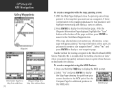
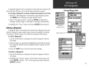
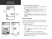
... press ENTER to the Find Menu Waypoints List. Another method for creating a waypoint is information in the mapping database for a Map Point without Data To create a waypoint with the map panning arrow: 1. GPSmap 60 GPS Navigation Using Waypoints Map Item selected as a waypoint. If there is the Man Overboard (MOB) feature. Do you want to the...
... press ENTER to the Find Menu Waypoints List. Another method for creating a waypoint is information in the mapping database for a Map Point without Data To create a waypoint with the map panning arrow: 1. GPSmap 60 GPS Navigation Using Waypoints Map Item selected as a waypoint. If there is the Man Overboard (MOB) feature. Do you want to the...
Owner's Manual
Page 29
... but only while the GPS has a fix on using the Find Feature. Highlight the "Delete" button at the bottom of the page and press ENTER. GPSmap 60 GPS Navigation Using Waypoints Waypoint Symbols Chart Delete Button Waypoint Options Menu Average Location Page 19 To average a Waypoint Location using the waypoint symbol chart... key to display the Average Location Page. Editing a Waypoint A waypoint can be selected from the Find Feature Waypoints list and edited to change the map symbol, name, location coordinates, elevation or to delete it . Press the QUIT key to close and save the changes.
... but only while the GPS has a fix on using the Find Feature. Highlight the "Delete" button at the bottom of the page and press ENTER. GPSmap 60 GPS Navigation Using Waypoints Waypoint Symbols Chart Delete Button Waypoint Options Menu Average Location Page 19 To average a Waypoint Location using the waypoint symbol chart... key to display the Average Location Page. Editing a Waypoint A waypoint can be selected from the Find Feature Waypoints list and edited to change the map symbol, name, location coordinates, elevation or to delete it . Press the QUIT key to close and save the changes.
Owner's Manual
Page 30
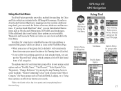
... the Information Page. 2. Use the ROCKER key to drag the waypoint to the desired location on the Map Page: 1. Press the FIND key to the waypoint. 4. GPSmap 60 GPS Navigation Using Waypoints New Location Original Location Moving a Waypoint Project Waypoint Page 20 Projected Waypoint on the... Map To move a Waypoint on the map and release to place it there. Press ENTER again to place a "Move" ...
... the Information Page. 2. Use the ROCKER key to drag the waypoint to the desired location on the Map Page: 1. Press the FIND key to the waypoint. 4. GPSmap 60 GPS Navigation Using Waypoints New Location Original Location Moving a Waypoint Project Waypoint Page 20 Projected Waypoint on the... Map To move a Waypoint on the map and release to place it there. Press ENTER again to place a "Move" ...
Owner's Manual
Page 31
...by default it will contain only those items near your search. * Refer to the Garmin website: http://www.garmin.com//cartography/mapSource/ bluechartCD.jsp GPSmap 60 GPS Navigation FIND Press the FIND key to the Find Menu. Waypoints and Geocache Points... are included in searching again for groups with a method for searching for those groups such as Food and Drink, Lodging, etc.). Searching for a map item is simplified because the map...
...by default it will contain only those items near your search. * Refer to the Garmin website: http://www.garmin.com//cartography/mapSource/ bluechartCD.jsp GPSmap 60 GPS Navigation FIND Press the FIND key to the Find Menu. Waypoints and Geocache Points... are included in searching again for groups with a method for searching for those groups such as Food and Drink, Lodging, etc.). Searching for a map item is simplified because the map...
Quick Start Guide
Page 1
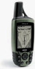
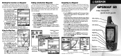
.... 3. Digital data fields at the bottom of the page. A Bearing line displays on the map, and the Position Arrow moves as destinations. 1. Compass Page Map Page Trip Computer © Copyright 2004 Garmin Ltd. A Printed in Taiwan ® GPSMAP 60 map navigator quick start guide GPS Antenna Power Key LCD Display In/Out (Zoom) Keys Page...
.... 3. Digital data fields at the bottom of the page. A Bearing line displays on the map, and the Position Arrow moves as destinations. 1. Compass Page Map Page Trip Computer © Copyright 2004 Garmin Ltd. A Printed in Taiwan ® GPSMAP 60 map navigator quick start guide GPS Antenna Power Key LCD Display In/Out (Zoom) Keys Page...


