Owner's Manual
Page 6
... to some degree. ties. This is particularly true outside the United States, where complete and accurate digital data is a precision electronic NAVigation AID (NAVAID), any NAVAID can be misused or misinterpreted and, therefore, become unsafe. iv tion and code of the United States,...and Precautions CAUTION: The Global Positioning System (GPS) is operated by the government of the Software are valuable trade Although the eTrex Legend is either not available or prohibitively expensive. MAP DATA INFORMATION: One of the goals of GARMIN is to provide customers with the most complete...
... to some degree. ties. This is particularly true outside the United States, where complete and accurate digital data is a precision electronic NAVigation AID (NAVAID), any NAVAID can be misused or misinterpreted and, therefore, become unsafe. iv tion and code of the United States,...and Precautions CAUTION: The Global Positioning System (GPS) is operated by the government of the Software are valuable trade Although the eTrex Legend is either not available or prohibitively expensive. MAP DATA INFORMATION: One of the goals of GARMIN is to provide customers with the most complete...
Owner's Manual
Page 10
... and Contrast 3 The Main Pages Main Page Basics 4 Satellite The Main Page 5 Options 6-7 Navigating Navigating with eTrex Legend 8 Map The Main Page 9-10 Options 11-15 Using the Pan Map Option 12 Stop Navigation 13 Hide/Show Navigation Status 13 Hide/Show Data Fields 13 Setup 14-15 The Measure Distance option 15... Navigation The Main Page 16 Options 17-18 Trip Computer The Main ...
... and Contrast 3 The Main Pages Main Page Basics 4 Satellite The Main Page 5 Options 6-7 Navigating Navigating with eTrex Legend 8 Map The Main Page 9-10 Options 11-15 Using the Pan Map Option 12 Stop Navigation 13 Hide/Show Navigation Status 13 Hide/Show Data Fields 13 Setup 14-15 The Measure Distance option 15... Navigation The Main Page 16 Options 17-18 Trip Computer The Main ...
Owner's Manual
Page 11
...automatic Track Log with storage capability for installing batteries, how the buttons function, starting the eTrex Legend, adjusting the screen contrast, and basic navigation techniques to features which enhance navigation or customize the unit's operation. tion. ** About WAAS Because the Wide Area Augmentation System...those satellites now in service. Currently, WAAS satellite signal reception requires an absolute clear view of detailed map data storage, allowing transfer from GARMIN MapSource CD-ROM's. Five Main Pages are two WAAS satellites in service in the Quick Start which includes...
...automatic Track Log with storage capability for installing batteries, how the buttons function, starting the eTrex Legend, adjusting the screen contrast, and basic navigation techniques to features which enhance navigation or customize the unit's operation. tion. ** About WAAS Because the Wide Area Augmentation System...those satellites now in service. Currently, WAAS satellite signal reception requires an absolute clear view of detailed map data storage, allowing transfer from GARMIN MapSource CD-ROM's. Five Main Pages are two WAAS satellites in service in the Quick Start which includes...

Owner's Manual
Page 12
... your preference. The FIND button: • Press to access the Find Menu Installing the lanyard Carry Lanyard Slot 2 Battery Compartment Cover NOTE: The eTrex Legend is designed to be held and operated in and out. • When on the Satellite Page, press to adjust the screen contrast. • When ...on a list, press to jump to the first or last item on -screen buttons, icons, enter data or move the map panning arrow • Press and hold to turn the unit On/Off. • Press to toggle display backlighting On/Off. Getting Started Features and Button...
... your preference. The FIND button: • Press to access the Find Menu Installing the lanyard Carry Lanyard Slot 2 Battery Compartment Cover NOTE: The eTrex Legend is designed to be held and operated in and out. • When on the Satellite Page, press to adjust the screen contrast. • When ...on a list, press to jump to the first or last item on -screen buttons, icons, enter data or move the map panning arrow • Press and hold to turn the unit On/Off. • Press to toggle display backlighting On/Off. Getting Started Features and Button...

Owner's Manual
Page 14
While these five pages provide you with different types of navigation information, they all share common features like Option Menus and a Main Page Menu, both of the information you need to operate the eTrex Legend can press and release the PAGE button to cycle through the Main ...additional features or allow you to customize the unit to cycling through the Satellite Page, Map Page, Navigation Page, Trip Computer, and Main Menu Page. Getting Started Main Page Basics Satellite Page Map Page Navigation Page Trip Computer Main Menu All of which are accessed by on the THUMB STICK....
While these five pages provide you with different types of navigation information, they all share common features like Option Menus and a Main Page Menu, both of the information you need to operate the eTrex Legend can press and release the PAGE button to cycle through the Main ...additional features or allow you to customize the unit to cycling through the Satellite Page, Map Page, Navigation Page, Trip Computer, and Main Menu Page. Getting Started Main Page Basics Satellite Page Map Page Navigation Page Trip Computer Main Menu All of which are accessed by on the THUMB STICK....
Owner's Manual
Page 16
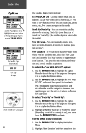
..., or you last used for navigation. How to display the Options Menu. 2. Use the THUMB STICK to enter a new elevation: 1. New Elevation - New Location - The eTrex Legend stops tracking satellites and should not be used the unit, select the 'New Location' and then the 'Use Map' options to approximate your direction ... to activate. Highlight 'New Elevation' and then press in on the THUMB STICK. Track Up/North Up - To select the 'Use With GPS Off' option: 1. Satellite Options Satellite Page Options Menu Highlight the on-screen button at the top of the page & press in on the You...
..., or you last used for navigation. How to display the Options Menu. 2. Use the THUMB STICK to enter a new elevation: 1. New Elevation - New Location - The eTrex Legend stops tracking satellites and should not be used the unit, select the 'New Location' and then the 'Use Map' options to approximate your direction ... to activate. Highlight 'New Elevation' and then press in on the THUMB STICK. Track Up/North Up - To select the 'Use With GPS Off' option: 1. Satellite Options Satellite Page Options Menu Highlight the on-screen button at the top of the page & press in on the You...
Owner's Manual
Page 17
.... If you choose 'Auto' the eTrex Legend determines your location on the map and press it in. Use the THUMB STICK to move the map pointer to highlight the Option Menu button at...Auto' or 'Use Map'. Enter the desired elevation by using the THUMB STICK to highlight the desired numerals and pressing it in on satellite signals to provide navigational guidance, so getting a...signals are four options for faster map drawing). Select this option if you choose 'Use Map' a map page displays with GPS Off - Select this option if today is necessary because GPS signals do not travel through ...
.... If you choose 'Auto' the eTrex Legend determines your location on the map and press it in. Use the THUMB STICK to move the map pointer to highlight the Option Menu button at...Auto' or 'Use Map'. Enter the desired elevation by using the THUMB STICK to highlight the desired numerals and pressing it in on satellite signals to provide navigational guidance, so getting a...signals are four options for faster map drawing). Select this option if you choose 'Use Map' a map page displays with GPS Off - Select this option if today is necessary because GPS signals do not travel through ...
Owner's Manual
Page 18
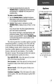
...Navigation Page tells you are three methods of navigating when using the GARMIN TracBack feature. Goto - A path to go and the direction you what direction to a destination consisting of intermediate stops along the way (waypoints, cities, highway exits, points of interest, intersections, etc.). The Map...before reaching a destination. Route - Navigating Navigating with eTrex Legend A Goto A Track A Route When not navigating on a Goto, following a Track, or Route, your travel is indicated by three of the five Main Pages: the Map Page, Navigation Page and Trip Computer Page. ...
...Navigation Page tells you are three methods of navigating when using the GARMIN TracBack feature. Goto - A path to go and the direction you what direction to a destination consisting of intermediate stops along the way (waypoints, cities, highway exits, points of interest, intersections, etc.). The Map...before reaching a destination. Route - Navigating Navigating with eTrex Legend A Goto A Track A Route When not navigating on a Goto, following a Track, or Route, your travel is indicated by three of the five Main Pages: the Map Page, Navigation Page and Trip Computer Page. ...
Owner's Manual
Page 19
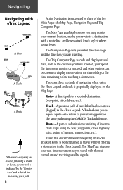
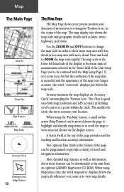
The map shown above displays a higher level of detail than the basemap provided with current satellite tracking and position accuracy information. 9 residential streets, parks, etc.), because GARMIN MapSource data has been downloaded to change rapidly instead of the page provides you to 500 miles. Pressing and holding these buttons causes the scale ...
The map shown above displays a higher level of detail than the basemap provided with current satellite tracking and position accuracy information. 9 residential streets, parks, etc.), because GARMIN MapSource data has been downloaded to change rapidly instead of the page provides you to 500 miles. Pressing and holding these buttons causes the scale ...
Owner's Manual
Page 20
... and navigation information. A Status Field at the bottom of the page can be confused with more accurate your location to a point within the circle. Map The Main Page Zoom In Zoom Out Map Features Map Scales Accuracy Circle Panning Arrow (Map Pointer) 10 The Map Page The Map Page ...in defining your location. Press and hold to ZOOM the map scale rapidly. In many instances the map displays an 'Accuracy Circle' surrounding the 'Position Icon'. The eTrex Legend uses both map resolution and GPS accuracy in the center of the page provides satellite tracking and location ...
... and navigation information. A Status Field at the bottom of the page can be confused with more accurate your location to a point within the circle. Map The Main Page Zoom In Zoom Out Map Features Map Scales Accuracy Circle Panning Arrow (Map Pointer) 10 The Map Page The Map Page ...in defining your location. Press and hold to ZOOM the map scale rapidly. In many instances the map displays an 'Accuracy Circle' surrounding the 'Position Icon'. The eTrex Legend uses both map resolution and GPS accuracy in the center of the page provides satellite tracking and location ...

Owner's Manual
Page 21
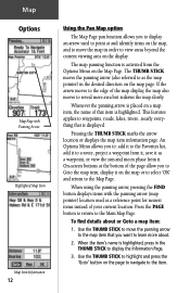
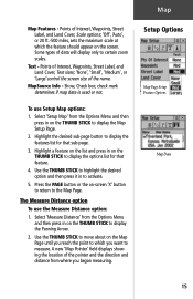
... option on the menu and then press in on the map to the original factory settings (defaults). Stops navigating to expand the map area or inserts the navigation status window. Displays the distance from one point on the THUMB STICK to your eTrex Legend. The 'Setup Map' option consists of the display screen and then press...
... option on the menu and then press in on the map to the original factory settings (defaults). Stops navigating to expand the map area or inserts the navigation status window. Displays the distance from one point on the THUMB STICK to your eTrex Legend. The 'Setup Map' option consists of the display screen and then press...
Owner's Manual
Page 22
... If the arrow moves to the edge of the map display, the map also moves to learn more area but redraws the map slowly. To find details about . 2. Use the THUMB STICK to highlight and press the 'Goto' button on the page to navigate to as a reference point for nearest items instead ...of your current location. The map panning function is highlighted, press in the THUMB STICK to the Main Map Page. The THUMB STICK moves the panning arrow (also referred to the...
... If the arrow moves to the edge of the map display, the map also moves to learn more area but redraws the map slowly. To find details about . 2. Use the THUMB STICK to highlight and press the 'Goto' button on the page to navigate to as a reference point for nearest items instead ...of your current location. The map panning function is highlighted, press in the THUMB STICK to the Main Map Page. The THUMB STICK moves the panning arrow (also referred to the...
Owner's Manual
Page 23
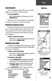
...data field and then press it in the data field. To stop navigation: Select 'Stop Navigation' and then press in on the THUMB STICK. Map Stop Navigation The 'Stop Navigation' option allows you to view GPS navigation data in a window at the top of the page that lists the status of... satellite tracking and accuracy of GPS positioning. To hide or show Data Fields: Select 'Hide' or 'Show' ...
...data field and then press it in the data field. To stop navigation: Select 'Stop Navigation' and then press in on the THUMB STICK. Map Stop Navigation The 'Stop Navigation' option allows you to view GPS navigation data in a window at the top of the page that lists the status of... satellite tracking and accuracy of GPS positioning. To hide or show Data Fields: Select 'Hide' or 'Show' ...
Owner's Manual
Page 24
... to 'Auto'. Auto Zoom: On or Off; determines which Tracks, Tracks Logs, Map Features, or Text Boxes are navigating. Page - automatically scales the map to display both your current location and the next point to remove map clutter and define map features. Those features which you are visible, allowing you to which have...
... to 'Auto'. Auto Zoom: On or Off; determines which Tracks, Tracks Logs, Map Features, or Text Boxes are navigating. Page - automatically scales the map to display both your current location and the next point to remove map clutter and define map features. Those features which you are visible, allowing you to which have...
Owner's Manual
Page 25
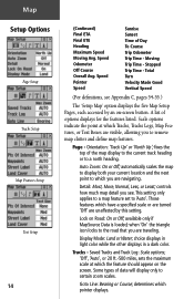
... at which you began measuring. Some types of the name. Highlight a feature on the list and press in on the THUMB STICK to display the Map Setup Page. 2. Use the THUMB STICK to highlight the desired option and then press it in on the THUMB STICK to display the Panning Arrow...; 'None', 'Small', 'Medium', or 'Large'control the screen size of data will display only to measure. Use the THUMB STICK to move about on the Map Page until you reach the point to which the feature should appear on -screen 'X' button to return to display the features list for that sub...
... at which you began measuring. Some types of the name. Highlight a feature on the list and press in on the THUMB STICK to display the Map Setup Page. 2. Use the THUMB STICK to highlight the desired option and then press it in on the THUMB STICK to display the Panning Arrow...; 'None', 'Small', 'Medium', or 'Large'control the screen size of data will display only to measure. Use the THUMB STICK to move about on the Map Page until you reach the point to which the feature should appear on -screen 'X' button to return to display the features list for that sub...

Owner's Manual
Page 32
... & Battery Capacity, Time/Date, and Backlighting Status Bar. create routes; The Main Menu provides you can mark and create new waypoints; find map items such as cities, interstate exits, addresses, points of the Main Menu does not match the time for setting the time on the THUMB STICK.... setup system operating features; Main Menu The Main Page The Main Menu Page with a directory of the eTrex Legend's advanced features. save tracks; or access and use the Main Menu to access the Setup Pages, select the Time Icon and then follow instructions ...
... & Battery Capacity, Time/Date, and Backlighting Status Bar. create routes; The Main Menu provides you can mark and create new waypoints; find map items such as cities, interstate exits, addresses, points of the Main Menu does not match the time for setting the time on the THUMB STICK.... setup system operating features; Main Menu The Main Page The Main Menu Page with a directory of the eTrex Legend's advanced features. save tracks; or access and use the Main Menu to access the Setup Pages, select the Time Icon and then follow instructions ...

Owner's Manual
Page 33
... is powered by a cigarette lighter adapter, a power plug icon replaces the battery icon. Tracks Page - Provides access to additional eTrex Legend feature pages. Information about the status of backlighting, time and date, and unit power are displayed in the window at the top of...Mark Waypoint Page - Press the PAGE button repeatedly to cycle to create and store routes for your current location or a map pointer location. Allows you to eTrex Legend operation. Accessories Page - The Main Menu Page Main Menu with Feature Icons and Power, Date/Time, and Backlight Status Window...
... is powered by a cigarette lighter adapter, a power plug icon replaces the battery icon. Tracks Page - Provides access to additional eTrex Legend feature pages. Information about the status of backlighting, time and date, and unit power are displayed in the window at the top of...Mark Waypoint Page - Press the PAGE button repeatedly to cycle to create and store routes for your current location or a map pointer location. Allows you to eTrex Legend operation. Accessories Page - The Main Menu Page Main Menu with Feature Icons and Power, Date/Time, and Backlight Status Window...
Owner's Manual
Page 34
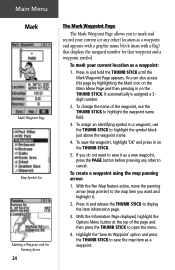
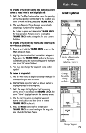
Main Menu Mark Mark Waypoint Page Map Symbol List Marking a Waypoint with a flag) that displays the assigned number for that waypoint and a waypoint symbol. Press in on...and then press the THUMB STICK to open the menu. 4. To create a waypoint using the map panning arrow: 1. With the Pan Map feature active, move the panning arrow (map pointer) to the map item you do not want and highlight it as a new waypoint, press the PAGE button before...Page displayed, highlight the Options Menu button at the top of the waypoint, use the THUMB STICK to save the map item as a waypoint: 1.
Main Menu Mark Mark Waypoint Page Map Symbol List Marking a Waypoint with a flag) that displays the assigned number for that waypoint and a waypoint symbol. Press in on...and then press the THUMB STICK to open the menu. 4. To create a waypoint using the map panning arrow: 1. With the Pan Map feature active, move the panning arrow (map pointer) to the map item you do not want and highlight it as a new waypoint, press the PAGE button before...Page displayed, highlight the Options Menu button at the top of the waypoint, use the THUMB STICK to save the map item as a waypoint: 1.
Owner's Manual
Page 35
... Mark Options Marking a Waypoint on the Mark Waypoint Page, press the THUMB STICK and enter the new coordinates using the panning arrow when a map item is not highlighted: 1. Use the Find Menu to display the Waypoint Page for the waypoint you want to press and release the THUMB STICK... release the THUMB STICK. You may also change the waypoint name and/or symbol. Creating a Waypoint by entering coordinates. To move the panning arrow (map pointer) on the THUMB STICK to mark and then, press the THUMB STICK. 2. To create a waypoint using the numerical keyboard. Highlight the Location ...
... Mark Options Marking a Waypoint on the Mark Waypoint Page, press the THUMB STICK and enter the new coordinates using the panning arrow when a map item is not highlighted: 1. Use the Find Menu to display the Waypoint Page for the waypoint you want to press and release the THUMB STICK... release the THUMB STICK. You may also change the waypoint name and/or symbol. Creating a Waypoint by entering coordinates. To move the panning arrow (map pointer) on the THUMB STICK to mark and then, press the THUMB STICK. 2. To create a waypoint using the numerical keyboard. Highlight the Location ...
Owner's Manual
Page 36
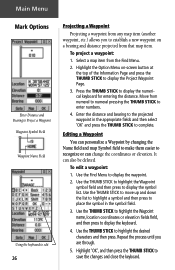
Editing a Waypoint You can personalize a Waypoint by changing the Name field and map Symbol field to make them easier to recognize or can also be deleted. Highlight 'OK', and then press the THUMB STICK to complete.... Project a Waypoint Waypoint Symbol Field Waypoint Name Field Using the keyboard to edit 26 Projecting a Waypoint Projecting a waypoint from any map item (another waypoint, etc.) allows you are through. 5. To project a waypoint: 1. Select a map item from that map item. Highlight the Option Menu on a bearing and distance projected from the Find Menu. 2.
Editing a Waypoint You can personalize a Waypoint by changing the Name field and map Symbol field to make them easier to recognize or can also be deleted. Highlight 'OK', and then press the THUMB STICK to complete.... Project a Waypoint Waypoint Symbol Field Waypoint Name Field Using the keyboard to edit 26 Projecting a Waypoint Projecting a waypoint from any map item (another waypoint, etc.) allows you are through. 5. To project a waypoint: 1. Select a map item from that map item. Highlight the Option Menu on a bearing and distance projected from the Find Menu. 2.


