
Owner's Manual
Page 16
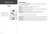
... Page: • Elevation-the measurement of height above mean sea level. • Heading-the direction you are traveling. • Location-shows your current location coordinates, UTM, latitude and longitude, etc. • Speed-tells you how fast you are going. • Time/Date-the current time and date based on your current...
... Page: • Elevation-the measurement of height above mean sea level. • Heading-the direction you are traveling. • Location-shows your current location coordinates, UTM, latitude and longitude, etc. • Speed-tells you how fast you are going. • Time/Date-the current time and date based on your current...
Owner's Manual
Page 35
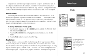
... User Grid Position Format and the User Map Datum Setup. 27 Position Format The default position format (and the one most commonly used) for the Geko 201 is usually listed in degrees and minutes (hdddº mm.mmm'). To change the datum if you are using a map with a paper map ...From the UNITS Page press the UP or DOWN Button to highlight the 'POSITION FRMT' field and press the OK Button. 2. The Geko 201 supports both the UTM/UPS and latitude/longitude grids, which is latitude and longitude in the title block of the Earth's shape. For more information on map datum...
... User Grid Position Format and the User Map Datum Setup. 27 Position Format The default position format (and the one most commonly used) for the Geko 201 is usually listed in degrees and minutes (hdddº mm.mmm'). To change the datum if you are using a map with a paper map ...From the UNITS Page press the UP or DOWN Button to highlight the 'POSITION FRMT' field and press the OK Button. 2. The Geko 201 supports both the UTM/UPS and latitude/longitude grids, which is latitude and longitude in the title block of the Earth's shape. For more information on map datum...
