Installation Instructions
Page 3
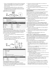
... to a Transducer Devices that can install single-pole, single-throw switches. Connecting the Device to a Garmin Marine Radar Devices that can receive depth information from the chartplotter to 100 mA. • To manually toggle visual and audible alerts, you can receive information from... the chartplotter displays a message. Go to www.garmin.com or contact your local Garmin dealer to determine the appropriate type of sonar device for your Garmin dealer. • If this device has a single ETHERNET port, you may need to use a Garmin network switch, such as a GPSMAP 8000 ...
... to a Transducer Devices that can install single-pole, single-throw switches. Connecting the Device to a Garmin Marine Radar Devices that can receive depth information from the chartplotter to 100 mA. • To manually toggle visual and audible alerts, you can receive information from... the chartplotter displays a message. Go to www.garmin.com or contact your local Garmin dealer to determine the appropriate type of sonar device for your Garmin dealer. • If this device has a single ETHERNET port, you may need to use a Garmin network switch, such as a GPSMAP 8000 ...
Installation Instructions
Page 4
...NMEA 2000 compatible devices such as a flush-mount installation, may contain a software-update memory card. NMEA 2000 compatible models can install a Garmin external GPS antenna and connect it to the device to provide GPS information. To download this situation, you have a port labeled EXT GPS....load the latest software onto a memory card. 1 Turn on the chartplotter. 2 Insert the memory card into the card slot on the computer. 2 Go to www.garmin.com/ support / software / marine .html. 3 Select Download next to "Garmin Marine Network with NMEA 2000, you must copy the software update ...
...NMEA 2000 compatible devices such as a flush-mount installation, may contain a software-update memory card. NMEA 2000 compatible models can install a Garmin external GPS antenna and connect it to the device to provide GPS information. To download this situation, you have a port labeled EXT GPS....load the latest software onto a memory card. 1 Turn on the chartplotter. 2 Insert the memory card into the card slot on the computer. 2 Go to www.garmin.com/ support / software / marine .html. 3 Select Download next to "Garmin Marine Network with NMEA 2000, you must copy the software update ...
Owner's Manual
Page 3
... and Chart Views ........ 6 AIS Display Settings 6 Laylines Settings 6 Navigation and Fishing Chart Setup 6 Overlay Numbers Settings 6 Chart Appearance Settings 7 Fish Eye 3D Settings 7 Navigation with a Chartplotter 7 Basic Navigation Questions 7 Destinations 8 Searching for a Destination by Name 8 Selecting a Destination Using the Navigation Chart 8 Searching for a Destination Using Nav Info 8 Searching for a Marine Services...
... and Chart Views ........ 6 AIS Display Settings 6 Laylines Settings 6 Navigation and Fishing Chart Setup 6 Overlay Numbers Settings 6 Chart Appearance Settings 7 Fish Eye 3D Settings 7 Navigation with a Chartplotter 7 Basic Navigation Questions 7 Destinations 8 Searching for a Destination by Name 8 Selecting a Destination Using the Navigation Chart 8 Searching for a Destination Using Nav Info 8 Searching for a Marine Services...

Owner's Manual
Page 4
...-Boat Offset 20 Measuring the Potential Front-of-Boat Offset 20 Setting the Front-of-Boat Offset 20 Digital Selective Calling 20 Networked Chartplotter and VHF Radio Functionality 20 Turning On DSC 20 DSC List 20 Viewing the DSC List 20 Adding a DSC Contact 20 Incoming...Calls 20 Navigating to a Vessel in Distress 21 Man-Overboard Distress Calls Initiated from a VHF Radio . 21 Man-Overboard Distress Calls Initiated from the Chartplotter 21 Position Tracking 21 Viewing a Position Report 21 Navigating to a Tracked Vessel 21 Creating a Waypoint at the Position of a Tracked Vessel ... ...
...-Boat Offset 20 Measuring the Potential Front-of-Boat Offset 20 Setting the Front-of-Boat Offset 20 Digital Selective Calling 20 Networked Chartplotter and VHF Radio Functionality 20 Turning On DSC 20 DSC List 20 Viewing the DSC List 20 Adding a DSC Contact 20 Incoming...Calls 20 Navigating to a Vessel in Distress 21 Man-Overboard Distress Calls Initiated from a VHF Radio . 21 Man-Overboard Distress Calls Initiated from the Chartplotter 21 Position Tracking 21 Viewing a Position Report 21 Navigating to a Tracked Vessel 21 Creating a Waypoint at the Position of a Tracked Vessel ... ...

Owner's Manual
Page 5
...Saving a SiriusXM Channel to the Presets List 25 Adjusting SiriusXM Satellite Radio Volume 25 Device Configuration 25 Turning On the Chartplotter Automatically 25 System Settings 25 GPS Settings 25 Viewing the Event Log 25 Viewing System Software Information 25 My Vessel Settings... 29 Cleaning the Screen 29 Screenshots 29 Capturing Screenshots 29 Copying Screenshots to a Computer 29 Troubleshooting 29 Restoring the Original Chartplotter Factory Settings 29 Viewing System Software Information 29 NMEA 0183 Information 30 NMEA 2000 PGN Information 30 Software License Agreement 30...
...Saving a SiriusXM Channel to the Presets List 25 Adjusting SiriusXM Satellite Radio Volume 25 Device Configuration 25 Turning On the Chartplotter Automatically 25 System Settings 25 GPS Settings 25 Viewing the Event Log 25 Viewing System Software Information 25 My Vessel Settings... 29 Cleaning the Screen 29 Screenshots 29 Capturing Screenshots 29 Copying Screenshots to a Computer 29 Troubleshooting 29 Restoring the Original Chartplotter Factory Settings 29 Viewing System Software Information 29 NMEA 0183 Information 30 NMEA 2000 PGN Information 30 Software License Agreement 30...
Owner's Manual
Page 7
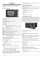
... your device, you can use blank memory cards to record sonar data and transfer data such as waypoints, routes, and tracks to another compatible Garmin chartplotter or a computer. 1 Open the access door on the screen (for touchscreen devices only). • Using the arrow keys to highlight a ... update memory card is used to describe these actions. • Touching an item on the front of the chartplotter. À 2 Insert the memory card with the label facing to "Garmin Marine Network with SD card. SELECT BACK MARK HOME MENU Acknowledges messages and selects options. Closes a menu, ...
... your device, you can use blank memory cards to record sonar data and transfer data such as waypoints, routes, and tracks to another compatible Garmin chartplotter or a computer. 1 Open the access door on the screen (for touchscreen devices only). • Using the arrow keys to highlight a ... update memory card is used to describe these actions. • Touching an item on the front of the chartplotter. À 2 Insert the memory card with the label facing to "Garmin Marine Network with SD card. SELECT BACK MARK HOME MENU Acknowledges messages and selects options. Closes a menu, ...
Owner's Manual
Page 8
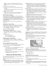
...GPS Satellite Signals When you to plan your present location. 1 From the chart, use features customized for depth recognition. When the chartplotter loses satellite signals, disappears and a flashing question mark appears over on the chart. Navigation Chart and Offshore Fishing Chart NOTE: The ... 2 Select an option. You can add items to www.garmin.com / aboutGPS. Red indicates the largest targets and green indicates the smallest. Selecting an Item on the Navigation chart or the Fishing chart, when the chartplotter is for offshore deep-sea fishing. Adjusting the Color Mode ...
...GPS Satellite Signals When you to plan your present location. 1 From the chart, use features customized for depth recognition. When the chartplotter loses satellite signals, disappears and a flashing question mark appears over on the chart. Navigation Chart and Offshore Fishing Chart NOTE: The ... 2 Select an option. You can add items to www.garmin.com / aboutGPS. Red indicates the largest targets and green indicates the smallest. Selecting an Item on the Navigation chart or the Fishing chart, when the chartplotter is for offshore deep-sea fishing. Adjusting the Color Mode ...
Owner's Manual
Page 9
... you can view information about Navaids From the Navigation chart, Fishing chart, Perspective 3D chart view, or Mariner's Eye 3D chart view, you visualize your chartplotter. NOTE: The offshore Fishing chart is based on the Chart CAUTION The Auto Guidance feature is available with premium charts, in some areas. Viewing Details...
... you can view information about Navaids From the Navigation chart, Fishing chart, Perspective 3D chart view, or Mariner's Eye 3D chart view, you visualize your chartplotter. NOTE: The offshore Fishing chart is based on the Chart CAUTION The Auto Guidance feature is available with premium charts, in some areas. Viewing Details...

Owner's Manual
Page 10
...or the 3D chart view. Target is reporting AIS information. If the AIS transmission from the vessel is lost , and the chartplotter displays a message banner asking whether the vessel should continue to Show. The direction of each vessel includes the Maritime Mobile Service ...direction in which the triangle is available with a transponder, and that target. 4 Charts and 3D Chart Views Target is lost , and the chartplotter displays a message banner asking whether the vessel should continue to arrival. 1 From the Navigation chart, select a camera icon: • To ...
...or the 3D chart view. Target is reporting AIS information. If the AIS transmission from the vessel is lost , and the chartplotter displays a message banner asking whether the vessel should continue to Show. The direction of each vessel includes the Maritime Mobile Service ...direction in which the triangle is available with a transponder, and that target. 4 Charts and 3D Chart Views Target is lost , and the chartplotter displays a message banner asking whether the vessel should continue to arrival. 1 From the Navigation chart, select a camera icon: • To ...

Owner's Manual
Page 11
... Signal Device Targeting Symbols Symbol Description AIS distress signal device transmission. To test an AIS emergency device, you must connect the chartplotter to intersect the safe zone. Charts and 3D Chart Views 5 A message banner appears and an alarm sounds when an AIS... of a pending intersection 10 minutes before the vessel intersects the safe zone. Navigating to a Distress Signal Transmission When you must enable the chartplotter to be customized. 1 Select Settings > Alarms > AIS > AIS Alarm > On. Enabling AIS Transmission Test Alerts To avoid a large...
... Signal Device Targeting Symbols Symbol Description AIS distress signal device transmission. To test an AIS emergency device, you must connect the chartplotter to intersect the safe zone. Charts and 3D Chart Views 5 A message banner appears and an alarm sounds when an AIS... of a pending intersection 10 minutes before the vessel intersects the safe zone. Navigating to a Distress Signal Transmission When you must enable the chartplotter to be customized. 1 Select Settings > Alarms > AIS > AIS Alarm > On. Enabling AIS Transmission Test Alerts To avoid a large...
Owner's Manual
Page 12
... Waypoints: Shows the Waypoints list (Viewing a List of the Navigation chart, when certain premium maps are shown on the chart, when the chartplotter is turned on track color. AIS Alarm: Sets the safe-zone collision alarm (Setting the Safe- From a chart or 3D chart view...Route Leg Details, and to select how the device calculates laylines. A true wind direction or apparent wind direction indicator appears if the chartplotter is disabled. AIS List: Shows the AIS list (Viewing a List of information about AIS-activated vessels. Zone Collision Alarm). Laylines ...
... Waypoints: Shows the Waypoints list (Viewing a List of the Navigation chart, when certain premium maps are shown on the chart, when the chartplotter is turned on track color. AIS Alarm: Sets the safe-zone collision alarm (Setting the Safe- From a chart or 3D chart view...Route Leg Details, and to select how the device calculates laylines. A true wind direction or apparent wind direction indicator appears if the chartplotter is disabled. AIS List: Shows the AIS list (Viewing a List of information about AIS-activated vessels. Zone Collision Alarm). Laylines ...

Owner's Manual
Page 13
...the present location? How do I make the device guide me in the direction in and Following a Direct Course Using which is available with a Chartplotter CAUTION If your destination. See Creating and Navigating a Route From Your Present Location. Navigation with a color scale. The navigation inset is shown ...: This feature is a line drawn on some chart views. From the Fish Eye 3D chart view, select MENU. How do I make the chartplotter Navigate using Route To. Spot Depths: Turns on the chart. World Map: Uses either a basic world map or a shaded relief map on ...
...the present location? How do I make the device guide me in the direction in and Following a Direct Course Using which is available with a Chartplotter CAUTION If your destination. See Creating and Navigating a Route From Your Present Location. Navigation with a color scale. The navigation inset is shown ...: This feature is a line drawn on some chart views. From the Fish Eye 3D chart view, select MENU. How do I make the chartplotter Navigate using Route To. Spot Depths: Turns on the chart. World Map: Uses either a basic world map or a shaded relief map on ...

Owner's Manual
Page 14
...Select Nav Info > Search by Name. 2 Enter at least a portion of the name of your search criteria appear. 4 Select the destination. The chartplotter contains information for thousands of interest, select Inland Services. • To search for me? You can set and follow a course to a selected ... feature is a thinner purple line that support Auto Guidance and are connected through a NMEA 2000® network to a compatible Garmin autopilot, you have premium maps that represents the corrected course from your current location to a destination using one of the magenta...
...Select Nav Info > Search by Name. 2 Enter at least a portion of the name of your search criteria appear. 4 Select the destination. The chartplotter contains information for thousands of interest, select Inland Services. • To search for me? You can set and follow a course to a selected ... feature is a thinner purple line that support Auto Guidance and are connected through a NMEA 2000® network to a compatible Garmin autopilot, you have premium maps that represents the corrected course from your current location to a destination using one of the magenta...

Owner's Manual
Page 15
...Marking and Starting Navigation to add more turns. 7 Select the final destination. An international MOB symbol marks the active MOB point and the chartplotter sets a direct course back to the present location of the waypoint, select Move. Editing a Saved Waypoint 1 Select Nav Info > Waypoints..., working backward from your present location. The starting from the destination to the marked location. NOTE: Auto Guidance is available with a Chartplotter 9 That data does not ensure obstacle and bottom clearance. Deleting a Waypoint or an MOB 1 Select Nav Info > Waypoints. 2 ...
...Marking and Starting Navigation to add more turns. 7 Select the final destination. An international MOB symbol marks the active MOB point and the chartplotter sets a direct course back to the present location of the waypoint, select Move. Editing a Saved Waypoint 1 Select Nav Info > Waypoints..., working backward from your present location. The starting from the destination to the marked location. NOTE: Auto Guidance is available with a Chartplotter 9 That data does not ensure obstacle and bottom clearance. Deleting a Waypoint or an MOB 1 Select Nav Info > Waypoints. 2 ...

Owner's Manual
Page 16
... the Active Track 1 Select Nav Info > Tracks > Active Track Options > Track Color. 2 Select a track color. Starboard. • To navigate the route from it moves with a Chartplotter Port. • To navigate the route from the starting point used when the route was created, to a Saved Route Before you are off course, follow...
... the Active Track 1 Select Nav Info > Tracks > Active Track Options > Track Color. 2 Select a track color. Starboard. • To navigate the route from it moves with a Chartplotter Port. • To navigate the route from the starting point used when the route was created, to a Saved Route Before you are off course, follow...

Owner's Manual
Page 17
... the information shown on the screen, select Change Function, and select new information. • To customize the data shown on all chartplotter models. Wind and Environment gauges require valid wind data from the destination point used when the track was created, select Backward. 5 Review...Select Nav Info > Tracks > Clear Active Track. The track memory is more accurate but fills the track log faster. Combinations 11 The chartplotters also provide almanac information about the trip, engine, environment, and wind, and are using the compass. 4 Select an option: •...
... the information shown on the screen, select Change Function, and select new information. • To customize the data shown on all chartplotter models. Wind and Environment gauges require valid wind data from the destination point used when the track was created, select Backward. 5 Review...Select Nav Info > Tracks > Clear Active Track. The track memory is more accurate but fills the track log faster. Combinations 11 The chartplotters also provide almanac information about the trip, engine, environment, and wind, and are using the compass. 4 Select an option: •...

Owner's Manual
Page 18
... 12 Gauges and Almanac Information Select Gauges > Engine. NOTE: Not all options are shown in the gauges, you add fuel to the chartplotter. Selecting the Number of fuel, select Add Fuel to turn on the wind gauge. Configuring the Fuel Gauges Display Before you can synchronize...Gauges Before you have a wind sensor connected to your vessel. 1 Select Gauges > Engine > MENU. 2 Select an option: • After you can enable the chartplotter to zero, select Reset All. Magnetic heading is based on water speed or GPS speed. 1 Select Gauges > Wind > MENU > Speed Display. 2 Select an ...
... 12 Gauges and Almanac Information Select Gauges > Engine. NOTE: Not all options are shown in the gauges, you add fuel to the chartplotter. Selecting the Number of fuel, select Add Fuel to turn on the wind gauge. Configuring the Fuel Gauges Display Before you can synchronize...Gauges Before you have a wind sensor connected to your vessel. 1 Select Gauges > Engine > MENU. 2 Select an option: • After you can enable the chartplotter to zero, select Reset All. Magnetic heading is based on water speed or GPS speed. 1 Select Gauges > Wind > MENU > Speed Display. 2 Select an ...

Owner's Manual
Page 19
...Environment Gauges Select Gauges > Environment. Setting the Barometer Reference Time You can be used to an optional Garmin sounder module and a transducer, your compatible chartplotter can specify the reference time used as Traditional and DownVü, a split-zoom view, and a ... Select Nav Info > Tides & Currents. 2 Select Tides or Currents. 3 Select Nearby Stations. 4 Select a station. There are in and the chartplotter model, sounder module, and transducer you view the fish in the barometer field. 1 Select Gauges > Environment > MENU > Pressure Ref. Tide, Current...
...Environment Gauges Select Gauges > Environment. Setting the Barometer Reference Time You can be used to an optional Garmin sounder module and a transducer, your compatible chartplotter can specify the reference time used as Traditional and DownVü, a split-zoom view, and a ... Select Nav Info > Tides & Currents. 2 Select Tides or Currents. 3 Select Nearby Stations. 4 Select a station. There are in and the chartplotter model, sounder module, and transducer you view the fish in the barometer field. 1 Select Gauges > Environment > MENU > Pressure Ref. Tide, Current...

Owner's Manual
Page 20
...; Old tires Ä Logs Å Distance from the right to the left. NOTE: To receive DownVü scanning sonar, you need a compatible chartplotter or fishfinder and a compatible transducer. DownVü high-frequency sonar provides a clearer picture below the boat, providing a more difficult to recognize actual returns....an option: • To increase or decrease the gain or brightness manually, select Up or Down. • To allow the chartplotter to adjust the gain or brightness automatically, select an automatic option. NOTE: To receive SideVü scanning sonar, you need a compatible...
...; Old tires Ä Logs Å Distance from the right to the left. NOTE: To receive DownVü scanning sonar, you need a compatible chartplotter or fishfinder and a compatible transducer. DownVü high-frequency sonar provides a clearer picture below the boat, providing a more difficult to recognize actual returns....an option: • To increase or decrease the gain or brightness manually, select Up or Down. • To allow the chartplotter to adjust the gain or brightness automatically, select an automatic option. NOTE: To receive SideVü scanning sonar, you need a compatible...
Owner's Manual
Page 21
... transducers. Wider beam widths also perform better in deep water, because the lower frequency has better deep water penetration Chirp frequencies allow the chartplotter to see deeper with the lower frequency return and at the bottom. From a sonar view, select MENU > Sonar Setup > Appearance .... For more surface noise and reduce bottom signal continuity during rough sea conditions. Creating a Frequency Preset NOTE: Not available with the chartplotter, you have . It can indicate which can be useful for deep water applications. If you to change the frequency quickly using a...
... transducers. Wider beam widths also perform better in deep water, because the lower frequency has better deep water penetration Chirp frequencies allow the chartplotter to see deeper with the lower frequency return and at the bottom. From a sonar view, select MENU > Sonar Setup > Appearance .... For more surface noise and reduce bottom signal continuity during rough sea conditions. Creating a Frequency Preset NOTE: Not available with the chartplotter, you have . It can indicate which can be useful for deep water applications. If you to change the frequency quickly using a...

