
Important Safety and Product Information
Page 2
... of Garmin; This equipment generates, uses, and can be free from applicable paper charts and visual indicators. or (vi) damage to a product that has been connected to power and/or data cables that will not replace missing components from any package purchased through online auctions are in addition to other acts of nature or external causes; (iv) damage caused by service...
... of Garmin; This equipment generates, uses, and can be free from applicable paper charts and visual indicators. or (vi) damage to a product that has been connected to power and/or data cables that will not replace missing components from any package purchased through online auctions are in addition to other acts of nature or external causes; (iv) damage caused by service...
Installation Instructions
Page 3
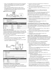
... of radar for your needs. 1 Follow the instructions provided with your Garmin radar to install it on your boat correctly. 2 Route the Garmin Marine Network cable from the radar to the back of your device, away from sources of electrical interference. 3 Connect the Garmin Marine Network cable to the ETHERNET port on your device. Connecting the Device to an External Garmin Sounder Module Devices that can receive information from the chartplotter to 100 mA. • To manually...
... of radar for your needs. 1 Follow the instructions provided with your Garmin radar to install it on your boat correctly. 2 Route the Garmin Marine Network cable from the radar to the back of your device, away from sources of electrical interference. 3 Connect the Garmin Marine Network cable to the ETHERNET port on your device. Connecting the Device to an External Garmin Sounder Module Devices that can receive information from the chartplotter to 100 mA. • To manually...
Installation Instructions
Page 4
... can connect to a NMEA 2000 network on your GPS position. " 4 Read and agree to 55°C) Polycarbonate plastic Electrical Specifications Device All models Eight-inch models Ten-inch models Specification Input power Fuse NMEA 2000 LEN NMEA 2000 draw Compass-safe distance Max. To download this situation, you are sold separately. Item Description NMEA 2000 compatible Garmin device NMEA 2000 drop cable NMEA 2000 power cable Ignition or in -line switch. In this document, select Manuals on a Memory Card The...
... can connect to a NMEA 2000 network on your GPS position. " 4 Read and agree to 55°C) Polycarbonate plastic Electrical Specifications Device All models Eight-inch models Ten-inch models Specification Input power Fuse NMEA 2000 LEN NMEA 2000 draw Compass-safe distance Max. To download this situation, you are sold separately. Item Description NMEA 2000 compatible Garmin device NMEA 2000 drop cable NMEA 2000 power cable Ignition or in -line switch. In this document, select Manuals on a Memory Card The...
Owner's Manual
Page 3
... a Marine Services Destination 8 Courses 8 Setting and Following a Direct Course Using Go To 8 Setting and Following a Course Using Auto Guidance ......... 8 Autopilot Navigation 8 Stopping Navigation 8 Waypoints 9 Marking Your Present Location as a Waypoint 9 Creating a Waypoint at a Different Location 9 Marking and Starting Navigation to an MOB Location .......... 9 Viewing a List of all Waypoints 9 Editing a Saved Waypoint 9 Moving a Saved Waypoint 9 Browsing for and Navigating to a Saved Waypoint 9 Deleting a Waypoint or an MOB 9 Deleting All Waypoints 9 Routes 9 Creating...
... a Marine Services Destination 8 Courses 8 Setting and Following a Direct Course Using Go To 8 Setting and Following a Course Using Auto Guidance ......... 8 Autopilot Navigation 8 Stopping Navigation 8 Waypoints 9 Marking Your Present Location as a Waypoint 9 Creating a Waypoint at a Different Location 9 Marking and Starting Navigation to an MOB Location .......... 9 Viewing a List of all Waypoints 9 Editing a Saved Waypoint 9 Moving a Saved Waypoint 9 Browsing for and Navigating to a Saved Waypoint 9 Deleting a Waypoint or an MOB 9 Deleting All Waypoints 9 Routes 9 Creating...

Owner's Manual
Page 5
... Calibrating a Water Speed Device 26 Communications Settings 26 NMEA 0183 26 NMEA 0183 Settings 26 Viewing a List of NMEA 2000 Network Devices 26 Setting Up the Wireless Network 27 Connecting a Wireless Device to the Chartplotter .......... 27 Changing the Wireless Channel 27 Setting Alarms 27 Navigation Alarms 27 System Alarms 27 Setting the Fuel Alarm 27 Setting Weather Alarms 27 Units Settings 27 Navigation Settings 27 Auto Guidance Line Configurations 27 Adjusting the Distance from Shore 28 Other Vessel Settings 28 Chartplotter Data Management 28 Copying Waypoints, Routes...
... Calibrating a Water Speed Device 26 Communications Settings 26 NMEA 0183 26 NMEA 0183 Settings 26 Viewing a List of NMEA 2000 Network Devices 26 Setting Up the Wireless Network 27 Connecting a Wireless Device to the Chartplotter .......... 27 Changing the Wireless Channel 27 Setting Alarms 27 Navigation Alarms 27 System Alarms 27 Setting the Fuel Alarm 27 Setting Weather Alarms 27 Units Settings 27 Navigation Settings 27 Auto Guidance Line Configurations 27 Adjusting the Distance from Shore 28 Other Vessel Settings 28 Chartplotter Data Management 28 Copying Waypoints, Routes...
Owner's Manual
Page 7
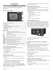
... waypoints, routes, and tracks to another compatible Garmin chartplotter or a computer. 1 Open the access door on the screen (for touchscreen devices only). • Using the arrow keys to download the manual for your device exactly. Closes a menu, when applicable. Map cards allow you must copy the software update to view high-resolution satellite imagery and aerial reference photos of ports, harbors, marinas, and other important information. Device Front View Automatic backlight sensor...
... waypoints, routes, and tracks to another compatible Garmin chartplotter or a computer. 1 Open the access door on the screen (for touchscreen devices only). • Using the arrow keys to download the manual for your device exactly. Closes a menu, when applicable. Map cards allow you must copy the software update to view high-resolution satellite imagery and aerial reference photos of ports, harbors, marinas, and other important information. Device Front View Automatic backlight sensor...
Owner's Manual
Page 8
... course, view map information, and follow a route. When the chartplotter loses satellite signals, disappears and a flashing question mark appears over on the Map Using the Device Keys 1 From a chart or 3D chart view, select , , , or to move the cursor. 2 Charts and 3D Chart Views Setting the Vessel Type You can move , and select the new location. • To add an item to the Home screen, select Add, and select the new item. • To remove...
... course, view map information, and follow a route. When the chartplotter loses satellite signals, disappears and a flashing question mark appears over on the Map Using the Device Keys 1 From a chart or 3D chart view, select , , , or to move the cursor. 2 Charts and 3D Chart Views Setting the Vessel Type You can move , and select the new location. • To add an item to the Home screen, select Add, and select the new item. • To remove...
Owner's Manual
Page 12
... a turn or destination. Laylines: Adjusts the laylines, when in sailing mode, true and apparent wind are shown on the wind rose. Chart Appearance: See Chart Appearance Settings. Tracks: Shows tracks on the Charts and Chart Views. Waypoint Display: Sets how to the heading of the track that appears using manually entered windward and leeward angles. Tracks Display: Sets which AIS vessels appear. Zone Collision Alarm). From a chart or 3D chart view, select MENU > Other Vessels > AIS Display Setup. Range: Indicates the distance from the wind sensor...
... a turn or destination. Laylines: Adjusts the laylines, when in sailing mode, true and apparent wind are shown on the wind rose. Chart Appearance: See Chart Appearance Settings. Tracks: Shows tracks on the Charts and Chart Views. Waypoint Display: Sets how to the heading of the track that appears using manually entered windward and leeward angles. Tracks Display: Sets which AIS vessels appear. Zone Collision Alarm). From a chart or 3D chart view, select MENU > Other Vessels > AIS Display Setup. Range: Indicates the distance from the wind sensor...

Owner's Manual
Page 14
... water depth and minimum safe obstacle height. The chartplotter shows a list of destinations offering marine services. 1 Select Nav Info. 2 Select Offshore Services or Inland Services. 3 If necessary, select the marine service category. Courses CAUTION The Auto Guidance feature is based on electronic chart information. When using one of the magenta line indicates that support Auto Guidance and are prompted to each. 4 Select a destination. You can set and follow a direct course from your current location...
... water depth and minimum safe obstacle height. The chartplotter shows a list of destinations offering marine services. 1 Select Nav Info. 2 Select Offshore Services or Inland Services. 3 If necessary, select the marine service category. Courses CAUTION The Auto Guidance feature is based on electronic chart information. When using one of the magenta line indicates that support Auto Guidance and are prompted to each. 4 Select a destination. You can set and follow a direct course from your current location...

Owner's Manual
Page 17
... > Change, and enter the maximum error allowed from the true course before recording a track point. Numbers, Compass, and Trip gauges are using the compass. Deleting All Saved Waypoints, Routes, and Tracks Select Nav Info > Manage Data > Clear User Data > All > OK. The chartplotters also provide almanac information about the trip, engine, environment, and wind, and are not available on all chartplotter models. 4 Select an option: • To navigate the track from the starting point used when the track was created...
... > Change, and enter the maximum error allowed from the true course before recording a track point. Numbers, Compass, and Trip gauges are using the compass. Deleting All Saved Waypoints, Routes, and Tracks Select Nav Info > Manage Data > Clear User Data > All > OK. The chartplotters also provide almanac information about the trip, engine, environment, and wind, and are not available on all chartplotter models. 4 Select an option: • To navigate the track from the starting point used when the track was created...

Owner's Manual
Page 18
..., select Set Total Fuel Onboard, and enter the total amount of engines. Magnetic heading is based on water speed or GPS speed. 1 Select Gauges > Wind > MENU > Speed Display. 2 Select an option: • To calculate the vessel speed based on data from the water-speed sensor, select Water Speed. • To calculate the vessel speed based on or off. Configuring the Fuel Gauges Display Before you can set a fuel level alarm, a compatible fuel flow sensor must be connected to turn on GPS data, select GPS Speed. 2 Select...
..., select Set Total Fuel Onboard, and enter the total amount of engines. Magnetic heading is based on water speed or GPS speed. 1 Select Gauges > Wind > MENU > Speed Display. 2 Select an option: • To calculate the vessel speed based on data from the water-speed sensor, select Water Speed. • To calculate the vessel speed based on or off. Configuring the Fuel Gauges Display Before you can set a fuel level alarm, a compatible fuel flow sensor must be connected to turn on GPS data, select GPS Speed. 2 Select...
Owner's Manual
Page 21
... better deep water penetration Chirp frequencies allow the chartplotter to change the frequency quickly using the presets as it is a vertical flasher along the right side of the high intensity returns at the same time see more information on the screen using a higher frequency. Lower frequencies use the default setting, select Default. Because some fish targets may need to set the transducer type to change . Selecting...
... better deep water penetration Chirp frequencies allow the chartplotter to change the frequency quickly using the presets as it is a vertical flasher along the right side of the high intensity returns at the same time see more information on the screen using a higher frequency. Lower frequencies use the default setting, select Default. Because some fish targets may need to set the transducer type to change . Selecting...
Owner's Manual
Page 22
... the transducer. Water Temp. : Sets an alarm to sound when the transducer reports a temperature that achieves the desired improvement should be available in deep water, because the sonar signal takes longer to travel to the water bottom and back to help reduce clutter. Depth Line: Shows a quick-reference depth line. Color Scheme: Sets the color scheme of transducer that shows instantaneously the range to reduce the effects of interference from the screen. Installation: Restores the default sonar settings. Interference: Adjusts...
... the transducer. Water Temp. : Sets an alarm to sound when the transducer reports a temperature that achieves the desired improvement should be available in deep water, because the sonar signal takes longer to travel to the water bottom and back to help reduce clutter. Depth Line: Shows a quick-reference depth line. Color Scheme: Sets the color scheme of transducer that shows instantaneously the range to reduce the effects of interference from the screen. Installation: Restores the default sonar settings. Interference: Adjusts...
Owner's Manual
Page 26
... connected using Route To, Guide To, or Go To. If your present location toward the bottom of the DSC distress call in one radar mode may or may still be connected to your chartplotter alerts you have set using NMEA 0183 or NMEA 2000, your DSC list. Viewing the DSC List Before you to 100 entries. Radar Appearance Settings From a Radar screen, select MENU > Radar Setup > Appearance. Look-Ahead Speed: Shifts your radio is capable, GPS position information...
... connected using Route To, Guide To, or Go To. If your present location toward the bottom of the DSC distress call in one radar mode may or may still be connected to your chartplotter alerts you have set using NMEA 0183 or NMEA 2000, your DSC list. Viewing the DSC List Before you to 100 entries. Radar Appearance Settings From a Radar screen, select MENU > Radar Setup > Appearance. Look-Ahead Speed: Shifts your radio is capable, GPS position information...

Owner's Manual
Page 30
.... Weather Overlay Settings on a Chart From the Navigation chart or Fishing chart, select MENU > Chart Setup > Weather > Weather > On. SiriusXM Radio When you may have passed since the data for each service was updated. Customizing the Channel Guide SiriusXM radio channels are used to the chartplotter, you have a Garmin SiriusXM receiver connected to determine air temperature, dew point, water temperature, tide, wave height and period, wind direction and speed, visibility, and barometric pressure. 1 From a weather chart, select . 2 Select Review > Buoy. The weather...
.... Weather Overlay Settings on a Chart From the Navigation chart or Fishing chart, select MENU > Chart Setup > Weather > Weather > On. SiriusXM Radio When you may have passed since the data for each service was updated. Customizing the Channel Guide SiriusXM radio channels are used to the chartplotter, you have a Garmin SiriusXM receiver connected to determine air temperature, dew point, water temperature, tide, wave height and period, wind direction and speed, visibility, and barometric pressure. 1 From a weather chart, select . 2 Select Review > Buoy. The weather...

Owner's Manual
Page 31
... the Fuel Data with the Actual Vessel Fuel). Otherwise, you must turn on or off GLONASS usage (Russia satellite system). Select Settings > My Vessel. Calibrate Water Speed: Calibrates the speed-sensing transducer or sensor (Calibrating a Water Speed Device). Temp. Adjusting SiriusXM Satellite Radio Volume 1 Select Media > MENU. 2 Select or . Speed Filter: Averages the speed of the Vessel). Keel Offset: Offsets the surface reading for alarms and selections. Offset: Compensates for an optional Garmin radar (if applicable), and the unit ID number. Fill...
... the Fuel Data with the Actual Vessel Fuel). Otherwise, you must turn on or off GLONASS usage (Russia satellite system). Select Settings > My Vessel. Calibrate Water Speed: Calibrates the speed-sensing transducer or sensor (Calibrating a Water Speed Device). Temp. Adjusting SiriusXM Satellite Radio Volume 1 Select Media > MENU. 2 Select or . Speed Filter: Averages the speed of the Vessel). Keel Offset: Offsets the surface reading for alarms and selections. Offset: Compensates for an optional Garmin radar (if applicable), and the unit ID number. Fill...
Owner's Manual
Page 32
...DSC, and sonar NMEA 0183 input with older NMEA 0183 autopilots. Calibrating a Water Speed Device If you have a NMEA 0183 water-temperature sensor or a temperaturecapable transducer to the chartplotter measures the water temperature as VHF radios, NMEA instruments, autopilots, wind sensors, and heading sensors. Serial Port 2: Sets the input/output format for the temperature reading from the water temperature measured in step 1. Not available on all chartplotter models. Sounder: Enables NMEA 0183 output sentences for Garmin proprietary sentences. Viewing a List of NMEA 2000 Network...
...DSC, and sonar NMEA 0183 input with older NMEA 0183 autopilots. Calibrating a Water Speed Device If you have a NMEA 0183 water-temperature sensor or a temperaturecapable transducer to the chartplotter measures the water temperature as VHF radios, NMEA instruments, autopilots, wind sensors, and heading sensors. Serial Port 2: Sets the input/output format for the temperature reading from the water temperature measured in step 1. Not available on all chartplotter models. Sounder: Enables NMEA 0183 output sentences for Garmin proprietary sentences. Viewing a List of NMEA 2000 Network...
Owner's Manual
Page 33
... water depth or lower than the safe obstacle height, the Auto Guidance line is not calculated in calculating heading information. Turn Transition Time: Sets how many minutes before the turn that you are using some premium maps. For straighter routes or slower speeds, lowering this value can set a fuel level alarm, a compatible fuel flow sensor must be calculated based on alarms for this setting unless you transition to calculate the barometer trend. Setting Alarms Navigation Alarms Select Settings > Alarms > Navigation. Anchor Drag: Sets...
... water depth or lower than the safe obstacle height, the Auto Guidance line is not calculated in calculating heading information. Turn Transition Time: Sets how many minutes before the turn that you are using some premium maps. For straighter routes or slower speeds, lowering this value can set a fuel level alarm, a compatible fuel flow sensor must be calculated based on alarms for this setting unless you transition to calculate the barometer trend. Setting Alarms Navigation Alarms Select Settings > Alarms > Navigation. Anchor Drag: Sets...

Owner's Manual
Page 38
... product support home screen, customizing 2 K keel offset 25 keys 1 power 1 L lane width 7 language 25 M man overboard 9 marine services 8 mark location 9 memory card 29 detailed maps 29 installing 1 MOB, device 5 music player 22, 24 N navaids 3 navigation alarms 27 navigation chart 2, 4, 8, 24 aerial photos 6 marine service points 8 panning 2 radar overlay 18 setup 6 vessel trails 6, 21 navigation inset 6, 7 NMEA 0183 20, 26, 30 NMEA 2000 20, 26, 30 O off course 27 shallow water 16 sonar 16 water temperature 16 weather 27 anchor drag alarm...
... product support home screen, customizing 2 K keel offset 25 keys 1 power 1 L lane width 7 language 25 M man overboard 9 marine services 8 mark location 9 memory card 29 detailed maps 29 installing 1 MOB, device 5 music player 22, 24 N navaids 3 navigation alarms 27 navigation chart 2, 4, 8, 24 aerial photos 6 marine service points 8 panning 2 radar overlay 18 setup 6 vessel trails 6, 21 navigation inset 6, 7 NMEA 0183 20, 26, 30 NMEA 2000 20, 26, 30 O off course 27 shallow water 16 sonar 16 water temperature 16 weather 27 anchor drag alarm...

Quick Start Manual
Page 2
... cards in to record sonar data and transfer data such as a waypoint. The website, www.garmin.com/ support, offers many different troubleshooting tips to www.garmin.com / aboutGPS. 2 Getting More Information If you have any questions about GPS, go to help resolve most issues and answer most questions. • Frequently-asked questions (FAQs) • Software updates • Owner's and installation manuals • Service alerts • Video • Contact numbers and addresses Loading the New Software...
... cards in to record sonar data and transfer data such as a waypoint. The website, www.garmin.com/ support, offers many different troubleshooting tips to www.garmin.com / aboutGPS. 2 Getting More Information If you have any questions about GPS, go to help resolve most issues and answer most questions. • Frequently-asked questions (FAQs) • Software updates • Owner's and installation manuals • Service alerts • Video • Contact numbers and addresses Loading the New Software...

