Owner's Manual
Page 14
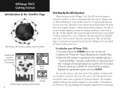
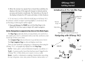
... Initialization & the Satellite Page The GPSmap 76CS locates satellites above you use your unit. In order to receive satellite signals, you must be outdoors and have a clear view of movement. To shorten the time required for initialization, select "New...by the Satellite Page. 3. Thereafter, if you turn on the GPSmap 76CS, the GPS receiver begins to turn on the unit. 2. Highlight the appropriate solution and press ENTER. Options Menu GPS Elevation display Satellite Page Acquiring Satellite Signals 4 Starting Up the GPS Receiver When you haven't moved more than 600 miles from 5 to ...
... Initialization & the Satellite Page The GPSmap 76CS locates satellites above you use your unit. In order to receive satellite signals, you must be outdoors and have a clear view of movement. To shorten the time required for initialization, select "New...by the Satellite Page. 3. Thereafter, if you turn on the GPSmap 76CS, the GPS receiver begins to turn on the unit. 2. Highlight the appropriate solution and press ENTER. Options Menu GPS Elevation display Satellite Page Acquiring Satellite Signals 4 Starting Up the GPS Receiver When you haven't moved more than 600 miles from 5 to ...
Owner's Manual
Page 15
... difficulty initializing your GPSmap 76CS, the solution could be as simple as moving slightly to indicate position accuracy and location coordinates. A direct path to a destination when using the GPSmap 76CS', each graphically displayed on the Map Page. When the receiver has signals from at least ...three satellites, the display at the top of the display indicates the GPS status and status of travel. There are now ready ...
... difficulty initializing your GPSmap 76CS, the solution could be as simple as moving slightly to indicate position accuracy and location coordinates. A direct path to a destination when using the GPSmap 76CS', each graphically displayed on the Map Page. When the receiver has signals from at least ...three satellites, the display at the top of the display indicates the GPS status and status of travel. There are now ready ...
Owner's Manual
Page 21
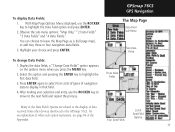
...Data Field Options are related to the display of data received from a list of types of navigation data to highlight the Data Field option and press ENTER. 2. With Map Page Options Menu displayed, use the ROCKER key to move to the GPSmap 76CS, for an explanation of what each option represents, see...pressing the ENTER key to leave the Map Page as is (full page map), or add two, three or four navigation data fields. 3. GPSmap 76CS GPS Navigation The Map Page Data Field Sub-Menu Two Data Fields To change Data Fields: 1. Press ENTER again to select from other devices interfaced to...
...Data Field Options are related to the display of data received from a list of types of navigation data to highlight the Data Field option and press ENTER. 2. With Map Page Options Menu displayed, use the ROCKER key to move to the GPSmap 76CS, for an explanation of what each option represents, see...pressing the ENTER key to leave the Map Page as is (full page map), or add two, three or four navigation data fields. 3. GPSmap 76CS GPS Navigation The Map Page Data Field Sub-Menu Two Data Fields To change Data Fields: 1. Press ENTER again to select from other devices interfaced to...
Owner's Manual
Page 24
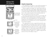
... to your destination. It uses a graphic compass ring and a bearing/ course pointer along with your GPSmap 76CS for guidance. The Bearing/Course Pointer indicates the direction (bearing) to your destination, relative to your current...to the next point on the route, estimated arrival time, etc. Whenever navigation is your heading. GPSmap 76CS GPS Navigation Using the Compass Page The Compass Page The Compass Ring moves to accurate and efficient navigation.... when using a paper map or chart in each from the GPS receiver to maintain your guide to indicate North orientation.
... to your destination. It uses a graphic compass ring and a bearing/ course pointer along with your GPSmap 76CS for guidance. The Bearing/Course Pointer indicates the direction (bearing) to your destination, relative to your current...to the next point on the route, estimated arrival time, etc. Whenever navigation is your heading. GPSmap 76CS GPS Navigation Using the Compass Page The Compass Page The Compass Ring moves to accurate and efficient navigation.... when using a paper map or chart in each from the GPS receiver to maintain your guide to indicate North orientation.
Owner's Manual
Page 25
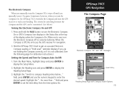
... when the Compass is Off, the unit uses the GPS receiver for navigation. 2. A Compass Icon displays in use the numeric keypad to enter the desired speed. A "Hold Level" reminder displays if you are not holding the Compass correctly, or if it On again. GPSmap 76CS GPS Navigation The Compass Page Electronic Compass "On" and "..., it stays off to compass heading when below .) Turning the Electronic Compass On and Off: 1. Sometimes, however, when you turn the Compass On, the GPSmap 76CS overrides the Compass and uses the GPS receiver to get an accurate Electronic Compass reading.
... when the Compass is Off, the unit uses the GPS receiver for navigation. 2. A Compass Icon displays in use the numeric keypad to enter the desired speed. A "Hold Level" reminder displays if you are not holding the Compass correctly, or if it On again. GPSmap 76CS GPS Navigation The Compass Page Electronic Compass "On" and "..., it stays off to compass heading when below .) Turning the Electronic Compass On and Off: 1. Sometimes, however, when you turn the Compass On, the GPSmap 76CS overrides the Compass and uses the GPS receiver to get an accurate Electronic Compass reading.
Owner's Manual
Page 68
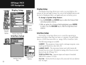
... a PC. The proprietary format used to exchange waypoint, route, track log and MapSource data with Garmin differential beacon receivers. Supports input and output of location and velocity information. No input. You can significantly save on battery power. GPSmap 76CS GPS Navigation Display Setup Color Scheme Options Backlight Timeout Options Display Setup Page Interface Setup Level...
... a PC. The proprietary format used to exchange waypoint, route, track log and MapSource data with Garmin differential beacon receivers. Supports input and output of location and velocity information. No input. You can significantly save on battery power. GPSmap 76CS GPS Navigation Display Setup Color Scheme Options Backlight Timeout Options Display Setup Page Interface Setup Level...
Owner's Manual
Page 69
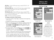
...explained at the beginning of the page. Use the ROCKER key to highlight the desired setting and press ENTER. 4. GPSmap 76CS GPS Navigation Interface Setup Data Format Page for GARMIN DGPS Data Format Page for RTCM In/NMEA Out Data Format Page for available beacon transmitters. When the USB is ... RTCM In/Text Out IMPORTANT NOTE: When the USB cable is selected, the GPSmap 76CS will automatically direct the beacon receiver to highlight "Beacon" and press ENTER. RTCM In/Text Out - Use the ROCKER key to the GPS map 76CS, it is selected, select the "Freq" and "Bit Rate" fields...
...explained at the beginning of the page. Use the ROCKER key to highlight the desired setting and press ENTER. 4. GPSmap 76CS GPS Navigation Interface Setup Data Format Page for GARMIN DGPS Data Format Page for RTCM In/NMEA Out Data Format Page for available beacon transmitters. When the USB is ... RTCM In/Text Out IMPORTANT NOTE: When the USB cable is selected, the GPSmap 76CS will automatically direct the beacon receiver to highlight "Beacon" and press ENTER. RTCM In/Text Out - Use the ROCKER key to the GPS map 76CS, it is selected, select the "Freq" and "Bit Rate" fields...
Owner's Manual
Page 79
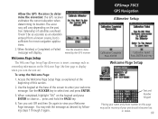
...depending on this section. 2. Use the keypad at the beginning of satellites overhead. mined by following steps 1 through 3 again. GPSmap 76CS GPS Navigation Altimeter Setup Calibration Complete Press ENTER Calibration Failed Press ENTER and retry Welcome Page Setup Text and Number Keypad Placing your name ...Page message. When finished, a Completed or Failed Use the elevation deter- When completed, highlight "OK" on ). Allow the GPS Receiver to select text and press ENTER. 3. Turn you turn the unit on the keypad and press ENTER to close or... Access the ...
...depending on this section. 2. Use the keypad at the beginning of satellites overhead. mined by following steps 1 through 3 again. GPSmap 76CS GPS Navigation Altimeter Setup Calibration Complete Press ENTER Calibration Failed Press ENTER and retry Welcome Page Setup Text and Number Keypad Placing your name ...Page message. When finished, a Completed or Failed Use the elevation deter- When completed, highlight "OK" on ). Allow the GPS Receiver to select text and press ENTER. 3. Turn you turn the unit on the keypad and press ENTER to close or... Access the ...

Owner's Manual
Page 92
GPSmap 76CS Appendix Specifications GPSmap 76CS 82 PHYSICAL Case: Rugged, fully gasketed, water resistant, IEC-529, IPX7 (Submersible 1 meter @ 30 minutes) Size: 6.2"H x 2.7"W x 1.4"D Weight: 7.6 ounces (216g) ... Altimeter: Accuracy; +/- 10 feet1, resolution; 1 foot Keypad: Operating Range: Nine multifunction backlit keys 5 to 158oF (-15 to 70oC)2 PERFORMANCE Receiver: Acquisition Time: Update Rate: GPS Accuracy Position: Velocity: WAAS enabled, 12 parallel channel Warm: Approximately 15 seconds Cold: Approximately 45 seconds AutoLocate™: Approximately 5 minutes Once per...
GPSmap 76CS Appendix Specifications GPSmap 76CS 82 PHYSICAL Case: Rugged, fully gasketed, water resistant, IEC-529, IPX7 (Submersible 1 meter @ 30 minutes) Size: 6.2"H x 2.7"W x 1.4"D Weight: 7.6 ounces (216g) ... Altimeter: Accuracy; +/- 10 feet1, resolution; 1 foot Keypad: Operating Range: Nine multifunction backlit keys 5 to 158oF (-15 to 70oC)2 PERFORMANCE Receiver: Acquisition Time: Update Rate: GPS Accuracy Position: Velocity: WAAS enabled, 12 parallel channel Warm: Approximately 15 seconds Cold: Approximately 45 seconds AutoLocate™: Approximately 5 minutes Once per...

Owner's Manual
Page 93
...64257;cantly reduce battery life. The temperature rating of the GPSmap 76CS may exceed the usable range of their capacity as the temperature decreases. WAAS accuracy in below-freezing conditions. Use Lithium batteries when operating the GPS map 76CS in North America. (DGPS using Beacon Receiver input.) 5. DGPS Accuracy Position: Velocity: 3-5 meters (10...Storage: Internal; Subject to 100m 2DRMS under the U.S. Some batteries can rupture at high temperatures. 3. DoD imposed Selective Availability (SA) Program when activated. 4. GPSmap 76CS Appendix Specifications 83
...64257;cantly reduce battery life. The temperature rating of the GPSmap 76CS may exceed the usable range of their capacity as the temperature decreases. WAAS accuracy in below-freezing conditions. Use Lithium batteries when operating the GPS map 76CS in North America. (DGPS using Beacon Receiver input.) 5. DGPS Accuracy Position: Velocity: 3-5 meters (10...Storage: Internal; Subject to 100m 2DRMS under the U.S. Some batteries can rupture at high temperatures. 3. DoD imposed Selective Availability (SA) Program when activated. 4. GPSmap 76CS Appendix Specifications 83

Owner's Manual
Page 104
... with the RTCM format sentences supported by ground reference stations. At this reason, your Garmin GPS receiver, when in the world when those systems (EGNOS and MSAS for use the same receiver frequency, any location in the "WAAS Enabled" mode, uses the method that broadcast ... services of your Garmin GPS. Refer to the System Setup Page of worldwide geostationary communication satellites that achieves the best accuracy. Refer to additional equipment in the developmental stage with a goal of the time. GPSmap 76CS Appendix WAAS and DGPS What is Differential GPS (DGPS)? What is...
... with the RTCM format sentences supported by ground reference stations. At this reason, your Garmin GPS receiver, when in the world when those systems (EGNOS and MSAS for use the same receiver frequency, any location in the "WAAS Enabled" mode, uses the method that broadcast ... services of your Garmin GPS. Refer to the System Setup Page of worldwide geostationary communication satellites that achieves the best accuracy. Refer to additional equipment in the developmental stage with a goal of the time. GPSmap 76CS Appendix WAAS and DGPS What is Differential GPS (DGPS)? What is...

Owner's Manual
Page 105
...: GPGGA, GPGLL, GPGSA, GPGSV, GPRMB, GPRMC, GPRTE, GPVTG, GPWPL, GPBOD Garmin Proprietary Sentences: PGRME (estimated error), PGRMM (datum string), PGRMZ (altitude), PSLIB (beacon receiver control) DGPS (Differential GPS) corrections are accepted in RTCM SC-104 version 2.0 format through the "Data In" line. GPSmap 76CS Appendix Interface Wiring Diagram Data In Power(+) Ground(-) Data Out Unit...
...: GPGGA, GPGLL, GPGSA, GPGSV, GPRMB, GPRMC, GPRTE, GPVTG, GPWPL, GPBOD Garmin Proprietary Sentences: PGRME (estimated error), PGRMM (datum string), PGRMZ (altitude), PSLIB (beacon receiver control) DGPS (Differential GPS) corrections are accepted in RTCM SC-104 version 2.0 format through the "Data In" line. GPSmap 76CS Appendix Interface Wiring Diagram Data In Power(+) Ground(-) Data Out Unit...


