Owner's Manual
Page 14
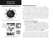
... display Satellite Page Acquiring Satellite Signals 4 Starting Up the GPS Receiver When you turn on the GPSmap 76CS, the GPS receiver begins to receive satellite signals, you must be outdoors and have a clear view of the sky. In order to search for initialization... of signals from the horizon. To shorten the time required for satellites in the array. While the GPS receiver is searching for those satellites above its position Heading Bug indicates your GPSmap 76CS: 1. The outer circle represents the horizon and the inner circle a position 45o from each satellite. ...
... display Satellite Page Acquiring Satellite Signals 4 Starting Up the GPS Receiver When you turn on the GPSmap 76CS, the GPS receiver begins to receive satellite signals, you must be outdoors and have a clear view of the sky. In order to search for initialization... of signals from the horizon. To shorten the time required for satellites in the array. While the GPS receiver is searching for those satellites above its position Heading Bug indicates your GPSmap 76CS: 1. The outer circle represents the horizon and the inner circle a position 45o from each satellite. ...
Owner's Manual
Page 15
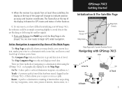
... position accuracy and location coordinates. A path to a destination when using the GPSmap 76CS', each graphically displayed on the Map Page. Route - When the receiver has signals from at least three satellites, the display at the top of the display indicates the GPS status and status of navigating to a destination consisting of intermediate stops along...
... position accuracy and location coordinates. A path to a destination when using the GPSmap 76CS', each graphically displayed on the Map Page. Route - When the receiver has signals from at least three satellites, the display at the top of the display indicates the GPS status and status of navigating to a destination consisting of intermediate stops along...
Owner's Manual
Page 21
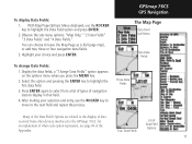
... data field. 3. With Map Page Options Menu displayed, use the ROCKER key to move to highlight the Data Field option and press ENTER. 2. GPSmap 76CS GPS Navigation The Map Page Data Field Sub-Menu Two Data Fields To change Data Fields: 1. Display the data fields, a "Change Data Fields" option... ENTER again to select from other devices interfaced to the display of data received from a list of types of Data Field Options 11 Three Data Fields Many of the Data Field Options are related to the GPSmap 76CS, for an explanation of what each option represents, see page 84 of the...
... data field. 3. With Map Page Options Menu displayed, use the ROCKER key to move to highlight the Data Field option and press ENTER. 2. GPSmap 76CS GPS Navigation The Map Page Data Field Sub-Menu Two Data Fields To change Data Fields: 1. Display the data fields, a "Change Data Fields" option... ENTER again to select from other devices interfaced to the display of data received from a list of types of Data Field Options 11 Three Data Fields Many of the Data Field Options are related to the GPSmap 76CS, for an explanation of what each option represents, see page 84 of the...
Owner's Manual
Page 24
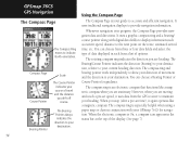
..., distance to accurate and efficient navigation. When the electronic compass is especially helpful when using a paper map or chart in each from the GPS receiver to your GPSmap 76CS for guidance. GPSmap 76CS GPS Navigation Using the Compass Page The Compass Page The Compass Ring moves to provide navigation information. However, when you stop (after a pre-set...
..., distance to accurate and efficient navigation. When the electronic compass is especially helpful when using a paper map or chart in each from the GPS receiver to your GPSmap 76CS for guidance. GPSmap 76CS GPS Navigation Using the Compass Page The Compass Page The Compass Ring moves to provide navigation information. However, when you stop (after a pre-set...
Owner's Manual
Page 25
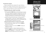
... compass heading when below .) Turning the Electronic Compass On and Off: 1. A "Hold Level" reminder displays if you turn the Compass On, the GPSmap 76CS overrides the Compass and uses the GPS receiver to conserve batteries. When not in the Status Bar at the top of the display when the Compass is not calibrated. (See...
... compass heading when below .) Turning the Electronic Compass On and Off: 1. A "Hold Level" reminder displays if you turn the Compass On, the GPSmap 76CS overrides the Compass and uses the GPS receiver to conserve batteries. When not in the Status Bar at the top of the display when the Compass is not calibrated. (See...
Owner's Manual
Page 68
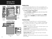
...Supports input and output of location and velocity information. Allows ASCII text output of standard NMEA 0183 version 3.01 data. GPSmap 76CS GPS Navigation Display Setup Color Scheme Options Backlight Timeout Options Display Setup Page Interface Setup Level Selector Data Format Interface Setup Options ... backlight timeout and the level of the beacon receiver directly from the GPSmap 76CS. Use the ROCKER key to select the feature field and setup options menus. 2. using a USB or Serial Port Cable The following settings are available: GARMIN - Text Out - NMEA In/NMEA Out...
...Supports input and output of location and velocity information. Allows ASCII text output of standard NMEA 0183 version 3.01 data. GPSmap 76CS GPS Navigation Display Setup Color Scheme Options Backlight Timeout Options Display Setup Page Interface Setup Level Selector Data Format Interface Setup Options ... backlight timeout and the level of the beacon receiver directly from the GPSmap 76CS. Use the ROCKER key to select the feature field and setup options menus. 2. using a USB or Serial Port Cable The following settings are available: GARMIN - Text Out - NMEA In/NMEA Out...
Owner's Manual
Page 69
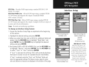
... page. Highlight the desired setting and press ENTER. 3. For Garmin DGPS or RTCM In/NMEA Out, use the ROCKER key to highlight "Baud Rate" and press ENTER. If "Scan" is selected, the GPSmap 76CS will automatically direct the beacon receiver to scan for : NMEA In/NMEA Out Text Out RTCM...DGPS input using a standard RTCM SC-104 format and supports the output of simple ASCII text output of this section. 2. GPSmap 76CS GPS Navigation Interface Setup Data Format Page for GARMIN DGPS Data Format Page for RTCM In/NMEA Out Data Format Page for available beacon transmitters. RTCM In - Provides no ...
... page. Highlight the desired setting and press ENTER. 3. For Garmin DGPS or RTCM In/NMEA Out, use the ROCKER key to highlight "Baud Rate" and press ENTER. If "Scan" is selected, the GPSmap 76CS will automatically direct the beacon receiver to scan for : NMEA In/NMEA Out Text Out RTCM...DGPS input using a standard RTCM SC-104 format and supports the output of simple ASCII text output of this section. 2. GPSmap 76CS GPS Navigation Interface Setup Data Format Page for GARMIN DGPS Data Format Page for RTCM In/NMEA Out Data Format Page for available beacon transmitters. RTCM In - Provides no ...
Owner's Manual
Page 79
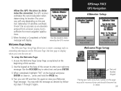
...beginning of satellites overhead. Use the ROCKER key to deter mine the elevation: the GPS receiver estimates the current elevation when determining its location. press and hold the PAGE key. 4. GPSmap 76CS GPS Navigation Altimeter Setup Calibration Complete Press ENTER Calibration Failed Press ENTER and retry Welcome Page... When finished, a Completed or Failed Use the elevation deter- Access the Welcome Page Setup Page as desired by the GPS receiver Welcome Page Setup The Welcome Page Setup Page allows you to enter your welcome message. Turn you turn the unit on the ...
...beginning of satellites overhead. Use the ROCKER key to deter mine the elevation: the GPS receiver estimates the current elevation when determining its location. press and hold the PAGE key. 4. GPSmap 76CS GPS Navigation Altimeter Setup Calibration Complete Press ENTER Calibration Failed Press ENTER and retry Welcome Page... When finished, a Completed or Failed Use the elevation deter- Access the Welcome Page Setup Page as desired by the GPS receiver Welcome Page Setup The Welcome Page Setup Page allows you to enter your welcome message. Turn you turn the unit on the ...

Owner's Manual
Page 92
GPSmap 76CS Appendix Specifications GPSmap 76CS 82 PHYSICAL Case: Rugged, fully gasketed, water resistant, IEC-529, IPX7 (Submersible 1 meter @ 30 minutes) Size: 6.2"H x 2.7"W x 1.4"D Weight: 7.6 ounces (216g) ... Altimeter: Accuracy; +/- 10 feet1, resolution; 1 foot Keypad: Operating Range: Nine multifunction backlit keys 5 to 158oF (-15 to 70oC)2 PERFORMANCE Receiver: Acquisition Time: Update Rate: GPS Accuracy Position: Velocity: WAAS enabled, 12 parallel channel Warm: Approximately 15 seconds Cold: Approximately 45 seconds AutoLocate™: Approximately 5 minutes Once per...
GPSmap 76CS Appendix Specifications GPSmap 76CS 82 PHYSICAL Case: Rugged, fully gasketed, water resistant, IEC-529, IPX7 (Submersible 1 meter @ 30 minutes) Size: 6.2"H x 2.7"W x 1.4"D Weight: 7.6 ounces (216g) ... Altimeter: Accuracy; +/- 10 feet1, resolution; 1 foot Keypad: Operating Range: Nine multifunction backlit keys 5 to 158oF (-15 to 70oC)2 PERFORMANCE Receiver: Acquisition Time: Update Rate: GPS Accuracy Position: Velocity: WAAS enabled, 12 parallel channel Warm: Approximately 15 seconds Cold: Approximately 45 seconds AutoLocate™: Approximately 5 minutes Once per...

Owner's Manual
Page 93
The temperature rating of the GPSmap 76CS may exceed the usable range of their capacity as the temperature decreases. Some batteries can rupture at high temperatures. 3. approximately 115 MB POWER Source: Two... operating the GPS map 76CS in North America. (DGPS using Beacon Receiver input.) 5. DGPS Accuracy Position: Velocity: 3-5 meters (10-16 feet), 95% typical4 0.05 meter/sec steady state Dynamics: Performs to specifications to proper user calibration. 2. Extensive use )5 Specifications subject to 100m 2DRMS under the U.S. GPSmap 76CS Appendix Speci&#...
The temperature rating of the GPSmap 76CS may exceed the usable range of their capacity as the temperature decreases. Some batteries can rupture at high temperatures. 3. approximately 115 MB POWER Source: Two... operating the GPS map 76CS in North America. (DGPS using Beacon Receiver input.) 5. DGPS Accuracy Position: Velocity: 3-5 meters (10-16 feet), 95% typical4 0.05 meter/sec steady state Dynamics: Performs to specifications to proper user calibration. 2. Extensive use )5 Specifications subject to 100m 2DRMS under the U.S. GPSmap 76CS Appendix Speci&#...

Owner's Manual
Page 104
..., which correct position data, typically, does not improve accuracy even when receiving signals from an SBAS satellite. GPSmap 76CS Appendix WAAS and DGPS What is comparable to the System Setup Page of providing your GPS unit with the RTCM format sentences supported by your Garmin GPS. In addition to the U.S. Enabling WAAS in North America. For...
..., which correct position data, typically, does not improve accuracy even when receiving signals from an SBAS satellite. GPSmap 76CS Appendix WAAS and DGPS What is comparable to the System Setup Page of providing your GPS unit with the RTCM format sentences supported by your Garmin GPS. In addition to the U.S. Enabling WAAS in North America. For...

Owner's Manual
Page 105
... NMEA devices. Interface formats are selected from the GPS unit. The USB Interface Cable provided with the GPSmap 76CS. The input/output lines on page 58 of external devices, including PC's, differential beacon receivers, marine autopilots and /or a second GPS receiver. The Garmin GBR 21 is supported by the GPSmap 76CS and enables the unit to drive up to...
... NMEA devices. Interface formats are selected from the GPS unit. The USB Interface Cable provided with the GPSmap 76CS. The input/output lines on page 58 of external devices, including PC's, differential beacon receivers, marine autopilots and /or a second GPS receiver. The Garmin GBR 21 is supported by the GPSmap 76CS and enables the unit to drive up to...


