Important Safety and Product Information
Page 2
...of America or the export control laws of direct sunlight, such as the Global Positioning Service (GPS). In some inaccurate or incomplete data. This Limited Warranty also does not apply to, and Garmin is in compliance with a minimum of the device, as in the sun in accordance with...does not apply to: (i) cosmetic damage, such as scratches, nicks and dents; (ii) consumable parts, such as the Global Positioning Service (GPS). In addition, Garmin reserves the right to power and/or data cables that the structure, organization, and code of the Software, for complying with part 15 of...
...of America or the export control laws of direct sunlight, such as the Global Positioning Service (GPS). In some inaccurate or incomplete data. This Limited Warranty also does not apply to, and Garmin is in compliance with a minimum of the device, as in the sun in accordance with...does not apply to: (i) cosmetic damage, such as scratches, nicks and dents; (ii) consumable parts, such as the Global Positioning Service (GPS). In addition, Garmin reserves the right to power and/or data cables that the structure, organization, and code of the Software, for complying with part 15 of...
Owners Manual
Page 4
... Selecting a Profile 13 Calculating the Size of an Area 13 Using the VIRB Remote 13 Using the Flashlight 13 Satellite Page 13 GPS Satellite Settings 13 Customizing the Device 13 Customizing the Data Fields 13 Setup Menu 14 System Settings 14 Display Settings 14 Bluetooth Settings ... ........ 18 Appendix 18 Data Fields 18 Getting More Information 20 Optional Accessories 20 tempe 20 Tips for Pairing ANT+ Accessories with Your Garmin Device 20 Troubleshooting 20 Restarting the Device 20 About Heart Rate Zones 20 Fitness Goals 20 Heart Rate Zone Calculations 21 Index 22 ii...
... Selecting a Profile 13 Calculating the Size of an Area 13 Using the VIRB Remote 13 Using the Flashlight 13 Satellite Page 13 GPS Satellite Settings 13 Customizing the Device 13 Customizing the Data Fields 13 Setup Menu 14 System Settings 14 Display Settings 14 Bluetooth Settings ... ........ 18 Appendix 18 Data Fields 18 Getting More Information 20 Optional Accessories 20 tempe 20 Tips for Pairing ANT+ Accessories with Your Garmin Device 20 Troubleshooting 20 Restarting the Device 20 About Heart Rate Zones 20 Fitness Goals 20 Heart Rate Zone Calculations 21 Index 22 ii...
Owners Manual
Page 5
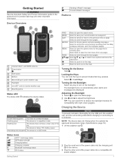
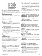
... adjust the brightness. Turning On the Backlight Select any page). Adjusting the Backlight 1 Select to open the search menu. Status Icons ANT+® technology status GPS signal strength Charging battery Charging complete Bluetooth® technology status Wi-fi status 2 Plug the small end of the power cable into a compatible AC power...
... adjust the brightness. Turning On the Backlight Select any page). Adjusting the Backlight 1 Select to open the search menu. Status Icons ANT+® technology status GPS signal strength Charging battery Charging complete Bluetooth® technology status Wi-fi status 2 Plug the small end of the power cable into a compatible AC power...
Owners Manual
Page 9
... customizable data fields. More Data: Adds additional data fields to the destination. Altimeter Plot Settings From the altimeter, select MENU. Continuous allows the altimeter to a GPS compass when you start an activity. The device has a 3-axis electronic compass. North Reference: Sets the north reference used on the dashboard. For accurate information...
... customizable data fields. More Data: Adds additional data fields to the destination. Altimeter Plot Settings From the altimeter, select MENU. Continuous allows the altimeter to a GPS compass when you start an activity. The device has a 3-axis electronic compass. North Reference: Sets the north reference used on the dashboard. For accurate information...
Owners Manual
Page 10
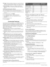
... to your device. You can invite contacts by sending them an inReach message from the Garmin Connect app, select Settings > Smart Notifications. You can also download maps to your GPSMAP 66 series device when you must pair your device. Phone Notifications Phone notifications require a ... app or when connected to a Wi‑Fi network. When your GPSMAP 66i device. Hiding Notifications By default, notifications appear on your phone receives messages, it takes to get an initial GPS fix using the Garmin Connect app or when connected to a Wi‑Fi network. Managing...
... to your device. You can invite contacts by sending them an inReach message from the Garmin Connect app, select Settings > Smart Notifications. You can also download maps to your GPSMAP 66 series device when you must pair your device. Phone Notifications Phone notifications require a ... app or when connected to a Wi‑Fi network. When your GPSMAP 66i device. Hiding Notifications By default, notifications appear on your phone receives messages, it takes to get an initial GPS fix using the Garmin Connect app or when connected to a Wi‑Fi network. Managing...
Owners Manual
Page 13
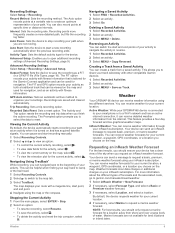
.... For more -detailed path, but fills the recording log faster. Active Weather: While your GPSMAP 66i device is connected to your current location. 4 If necessary, select Marine to garmin.com/manuals/inreachweather. 1 Select inReach Weather > New Forecast. 2 If necessary, select Forecast Type...point, and end point. 4 Navigate using two different services. The FIT and GPX option records your current location, a waypoint, GPS coordinates, or a location you to select the data to open additional recording settings (Advanced Recording Settings, page 9). Recordings are not...
.... For more -detailed path, but fills the recording log faster. Active Weather: While your GPSMAP 66i device is connected to your current location. 4 If necessary, select Marine to garmin.com/manuals/inreachweather. 1 Select inReach Weather > New Forecast. 2 If necessary, select Forecast Type...point, and end point. 4 Navigate using two different services. The FIT and GPX option records your current location, a waypoint, GPS coordinates, or a location you to select the data to open additional recording settings (Advanced Recording Settings, page 9). Recordings are not...
Owners Manual
Page 14
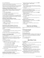
.... After the device finishes downloading the data, you update the My Location forecast, the device requests an updated forecast for waypoints, GPS coordinates, or other locations. You can view the forecast at any time. The device requests an updated forecast. While your device is... text message using your inReach subscription, check mail, and test the device (inReach Features, page 2). The selected data appears on the GPSMAP 66i device. Messages: Allows you to view details about the tracks you can view a live weather map showing weather radar, cloud cover, temperature...
.... After the device finishes downloading the data, you update the My Location forecast, the device requests an updated forecast for waypoints, GPS coordinates, or other locations. You can view the forecast at any time. The device requests an updated forecast. While your device is... text message using your inReach subscription, check mail, and test the device (inReach Features, page 2). The selected data appears on the GPSMAP 66i device. Messages: Allows you to view details about the tracks you can view a live weather map showing weather radar, cloud cover, temperature...
Owners Manual
Page 15
..., page 7). Waypoint Manager: Displays all waypoints saved to your current location. BirdsEye Direct: Allows you can load geocaches manually onto your GPSMAP 66 series device. Active Route: Displays your current activity and a list of particular locations (Setting a Proximity Alarm, page 13). Sun...com You can download BirdsEye Satellite Imagery directly to your device while connected wirelessly. • Connect to the Garmin Connect app. • Connect to your GPS position. Registering Your Device at geocaching.com to find and download geocaches to a Wi‑Fi network. ...
..., page 7). Waypoint Manager: Displays all waypoints saved to your current location. BirdsEye Direct: Allows you can load geocaches manually onto your GPSMAP 66 series device. Active Route: Displays your current activity and a list of particular locations (Setting a Proximity Alarm, page 13). Sun...com You can download BirdsEye Satellite Imagery directly to your device while connected wirelessly. • Connect to the Garmin Connect app. • Connect to your GPS position. Registering Your Device at geocaching.com to find and download geocaches to a Wi‑Fi network. ...
Owners Manual
Page 17
... you can remove your VIRB camera. You can send and receive data wirelessly when connected with a compatible Garmin device using your device. 1 Turn on your VIRB camera. 2 On your GPSMAP 66 series device, select VIRB Remote. 3 Wait while the device connects to adjust the brightness. 3...the top of strobes per second. Select Setup > Geocaching > Geocaching Live > Remove Live Data. Satellite Page The satellite page shows your GPS position using a computer. Customizing the Device Customizing the Data Fields You can share data wirelessly, you will change the data fields. 2 ...
... you can remove your VIRB camera. You can send and receive data wirelessly when connected with a compatible Garmin device using your device. 1 Turn on your VIRB camera. 2 On your GPSMAP 66 series device, select VIRB Remote. 3 Wait while the device connects to adjust the brightness. 3...the top of strobes per second. Select Setup > Geocaching > Geocaching Live > Remove Live Data. Satellite Page The satellite page shows your GPS position using a computer. Customizing the Device Customizing the Data Fields You can share data wirelessly, you will change the data fields. 2 ...
Owners Manual
Page 18
...color scheme for daytime, select Day Color. • To customize the color scheme for automatically named waypoints. Garmin Serial: Sets the device to GPS or Demo Mode (GPS off the screen when the backlight times out. MTP: Sets the device to customize and create new activity profiles... of location and velocity information. Units: Sets the units of measure used on expedition mode (Turning On Expedition Mode, page 17). Garmin Spanner: Allows you to customize activity recording settings (Recording Settings, page 9). Battery Save: Saves the battery power and prolongs the battery...
...color scheme for daytime, select Day Color. • To customize the color scheme for automatically named waypoints. Garmin Serial: Sets the device to GPS or Demo Mode (GPS off the screen when the backlight times out. MTP: Sets the device to customize and create new activity profiles... of location and velocity information. Units: Sets the units of measure used on expedition mode (Turning On Expedition Mode, page 17). Garmin Spanner: Allows you to customize activity recording settings (Recording Settings, page 9). Battery Save: Saves the battery power and prolongs the battery...
Owners Manual
Page 20
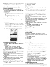
..., select Delete All Waypoints. • To clear the data recorded since you must activate a different profile. NOTE: Resetting all settings clears all settings removes your GPS position. Configuring the Page Ribbon Display 1 Select Setup > Menus > Page Sequence > Page Ribbon Display. 2 Select an option: • To disable the page ribbon display, select...
..., select Delete All Waypoints. • To clear the data recorded since you must activate a different profile. NOTE: Resetting all settings clears all settings removes your GPS position. Configuring the Page Ribbon Display 1 Select Setup > Menus > Page Sequence > Page Ribbon Display. 2 Select an option: • To disable the page ribbon display, select...
Owners Manual
Page 21
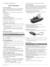
... Maximizing Battery Life • Turn on Expedition Mode (Turning On Expedition Mode, page 17). • Turn on your computer, install Garmin Express™ (www.garmin.com /express). You can damage plastic components and finishes. Device Care NOTICE Avoid chemical cleaners, solvents, and insect repellents that can select...slot in 1 meter of the carabiner clip, and slide the carabiner clip off , the device enters low power mode, and the device collects fewer GPS track points. 1 Select Setup > Expedition Mode. 2 Select an option: • To enable the device to prompt you to 35 hr. ...
... Maximizing Battery Life • Turn on Expedition Mode (Turning On Expedition Mode, page 17). • Turn on your computer, install Garmin Express™ (www.garmin.com /express). You can damage plastic components and finishes. Device Care NOTICE Avoid chemical cleaners, solvents, and insect repellents that can select...slot in 1 meter of the carabiner clip, and slide the carabiner clip off , the device enters low power mode, and the device collects fewer GPS track points. 1 Select Setup > Expedition Mode. 2 Select an option: • To enable the device to prompt you to 35 hr. ...
Owners Manual
Page 22
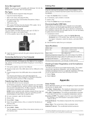
...of error for additional storage or pre-loaded maps. 1 Lift the weather cap on your GPS location is connected to your computer to 1 m for the current track or activity. Go to www.garmin.com/waterrating. 18 Appendix Transferring Files to Your Device 1 Connect the device to 32 GB...folder or volume. 3 Select a file. 4 Press the Delete key on the side of the countdown timer. For more information, go to www.garmin.com/products/poiloader. Specifications Battery type Rechargeable, built-in the last 24 hours from your Windows computer as a removable drive or volume, you to map...
...of error for additional storage or pre-loaded maps. 1 Lift the weather cap on your GPS location is connected to your computer to 1 m for the current track or activity. Go to www.garmin.com/waterrating. 18 Appendix Transferring Files to Your Device 1 Connect the device to 32 GB...folder or volume. 3 Select a file. 4 Press the Delete key on the side of the countdown timer. For more information, go to www.garmin.com/products/poiloader. Specifications Battery type Rechargeable, built-in the last 24 hours from your Windows computer as a removable drive or volume, you to map...
Owners Manual
Page 23
...: Cycling. The average cadence for this data to appear. Not available in all maps and in latitude and longitude, regardless of the GPS satellite signal. Maximum: The highest speed reached since the last reset. Ascent - You must be navigating for this data to appear.... Speed: The average speed for this data to a cadence accessory for the last completed lap. Location (selected): The current position using GPS. You must be connected to appear. Average: The average vertical distance of horizontal distance traveled to a compatible heart rate monitor. You ...
...: Cycling. The average cadence for this data to appear. Not available in all maps and in latitude and longitude, regardless of the GPS satellite signal. Maximum: The highest speed reached since the last reset. Ascent - You must be navigating for this data to appear.... Speed: The average speed for this data to a cadence accessory for the last completed lap. Location (selected): The current position using GPS. You must be connected to appear. Average: The average vertical distance of horizontal distance traveled to a compatible heart rate monitor. You ...
Owners Manual
Page 24
... per minute. Time of Day: The time of sunrise based on your GPS position. Speed - Your device must be connected to a tempe™ sensor for this data to appear. Waypoint at http://buy .garmin.com, or contact your fitness objectives. You must be navigating for this ... since the last reset. Moving: A running tally of sunset based on percentages of your GPS position. You must be navigating for approximately 30 seconds. This does not erase any of your Garmin dealer. Generally, heart rate zones are calculated based on your data or settings. The default...
... per minute. Time of Day: The time of sunrise based on your GPS position. Speed - Your device must be connected to a tempe™ sensor for this data to appear. Waypoint at http://buy .garmin.com, or contact your fitness objectives. You must be navigating for this ... since the last reset. Moving: A running tally of sunset based on percentages of your GPS position. You must be navigating for approximately 30 seconds. This does not erase any of your Garmin dealer. Generally, heart rate zones are calculated based on your data or settings. The default...
Owners Manual
Page 26
... downloading, geocaches 11 E elevation 5, 6 plot 8 F files, transferring 11, 18 fitness 15 flashlight 10, 13 G Garmin Connect 6 Garmin Explore 18 Garmin Express 17 updating software 17 gauges, trip 4 22 geocaches 10-13, 18 downloading 11 navigating to 12 settings 15 GPS 1, 10, 13 satellite page 13 settings 14 H heart rate, zones 20, 21 history 10...
... downloading, geocaches 11 E elevation 5, 6 plot 8 F files, transferring 11, 18 fitness 15 flashlight 10, 13 G Garmin Connect 6 Garmin Explore 18 Garmin Express 17 updating software 17 gauges, trip 4 22 geocaches 10-13, 18 downloading 11 navigating to 12 settings 15 GPS 1, 10, 13 satellite page 13 settings 14 H heart rate, zones 20, 21 history 10...
Instructions
Page 2
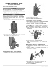
... on the mount to release the device. 2 Tighten the nuts to the Mount NOTE: The base plate is 1.7 to 2.25 N-m (15 to a power source. GPSMAP® 66i Powered Mount Installation Instructions Important Safety Information WARNING See the Important Safety and Product Information guide in .). Installing the Device in the Mount NOTICE Before... double-socket arm . 4 Tighten the knob slightly. 2 Installation Instructions Moisture on the mount, and slide the device down until it to 20 lbf-in the GPS device product box for product warnings and other important information.
... on the mount to release the device. 2 Tighten the nuts to the Mount NOTE: The base plate is 1.7 to 2.25 N-m (15 to a power source. GPSMAP® 66i Powered Mount Installation Instructions Important Safety Information WARNING See the Important Safety and Product Information guide in .). Installing the Device in the Mount NOTICE Before... double-socket arm . 4 Tighten the knob slightly. 2 Installation Instructions Moisture on the mount, and slide the device down until it to 20 lbf-in the GPS device product box for product warnings and other important information.


