Owners Manual
Page 3
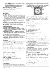
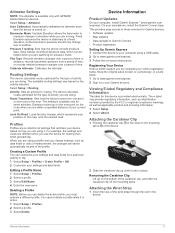
...GPSMAP Device Overview (Camera 1 Battery Information 1 Maximizing Battery Life 1 Turning On Battery Save Mode 1 Long-Term Storage 1 Installing a NiMH Battery Pack 1 Charging the Battery Pack 2 Installing AA Batteries 2 Turning On the Device 2 Keys 2 Acquiring Satellite Signals 2 Using the Main Pages 2 Opening the Main Menu 2 Map 2 Changing the Map Orientation 2 Measuring Distance on the Map 3 Map... 6 Calculating the Size of an Area 6 Satellite Page 6 GPS Satellite Settings 6 Garmin Adventures 7 Sending Files to BaseCamp 7 Creating an Adventure 7 Starting an Adventure 7 ...
...GPSMAP Device Overview (Camera 1 Battery Information 1 Maximizing Battery Life 1 Turning On Battery Save Mode 1 Long-Term Storage 1 Installing a NiMH Battery Pack 1 Charging the Battery Pack 2 Installing AA Batteries 2 Turning On the Device 2 Keys 2 Acquiring Satellite Signals 2 Using the Main Pages 2 Opening the Main Menu 2 Map 2 Changing the Map Orientation 2 Measuring Distance on the Map 3 Map... 6 Calculating the Size of an Area 6 Satellite Page 6 GPS Satellite Settings 6 Garmin Adventures 7 Sending Files to BaseCamp 7 Creating an Adventure 7 Starting an Adventure 7 ...
Owners Manual
Page 5
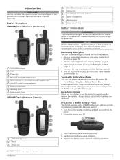
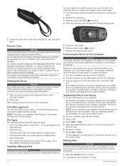
... for product warnings and other important information. In battery save mode (Turning On Battery Save Mode, page 1). • Decrease the map drawing speed (Map Settings, page 3). • Turn off when the backlight times out. Stored data is not included on the screen, and you ...) MCX connector for GPS antenna (under weather cap)1 microSD® card slot (under batteries) Battery compartment Mounting spine Battery cover D-ring GPSMAP Device Overview (Camera) Mini-USB port (under weather cap) Camera lens microSD card slot (under batteries) Battery compartment Mounting spine Battery cover...
... for product warnings and other important information. In battery save mode (Turning On Battery Save Mode, page 1). • Decrease the map drawing speed (Map Settings, page 3). • Turn off when the backlight times out. Stored data is not included on the screen, and you ...) MCX connector for GPS antenna (under weather cap)1 microSD® card slot (under batteries) Battery compartment Mounting spine Battery cover D-ring GPSMAP Device Overview (Camera) Mini-USB port (under weather cap) Camera lens microSD card slot (under batteries) Battery compartment Mounting spine Battery cover...
Owners Manual
Page 6
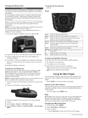
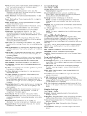
.... Attempting to open . Keys FIND MARK QUIT ENTER MENU PAGE IN OUT Select to charge a battery that was not provided by Garmin®. Select PAGE to the previous menu or page. Map represents your device, you are navigating to a destination, your computer. 1 Pull up to scroll through the main pages. Before you...
.... Attempting to open . Keys FIND MARK QUIT ENTER MENU PAGE IN OUT Select to charge a battery that was not provided by Garmin®. Select PAGE to the previous menu or page. Map represents your device, you are navigating to a destination, your computer. 1 Pull up to scroll through the main pages. Before you...
Owners Manual
Page 7
...should calibrate the compass after moving . It can measure the distance between dots on the course deviation indicator, which map items will not appear when the map zoom level is available only with GPSMAP 64s/sc/st/sx/csx devices. 1 Select Sight 'N Go. 2 Point the device at the top of the...: Shows detail relief on the page. The device has a 3-axis electronic compass (GPSMAP 64s/sc/st/sx/csx devices only). Measuring Distance on the Map You can also help you are navigating on the map. Navigating with the direction of travel toward the top of your relationship to the course...
...should calibrate the compass after moving . It can measure the distance between dots on the course deviation indicator, which map items will not appear when the map zoom level is available only with GPSMAP 64s/sc/st/sx/csx devices. 1 Select Sight 'N Go. 2 Point the device at the top of the...: Shows detail relief on the page. The device has a 3-axis electronic compass (GPSMAP 64s/sc/st/sx/csx devices only). Measuring Distance on the Map You can also help you are navigating on the map. Navigating with the direction of travel toward the top of your relationship to the course...
Owners Manual
Page 8
... been. Editing a Route 1 Select Route Planner. 2 Select a route. 3 Select Edit Route. 4 Select a point. 5 Select an option: • To view the point on the map, select Review. • To change the order of waypoints or locations that leads you know the correct elevation or the correct barometric pressure. By default... location by transferring the file to the GPX folder (Transferring Files to Your Device, page 12). NOTE: The barometric altimeter is available only with GPSMAP 64s/sc/st/sx/csx devices. 1 Go to a location where the elevation or barometric pressure is available only with...
... been. Editing a Route 1 Select Route Planner. 2 Select a route. 3 Select Edit Route. 4 Select a point. 5 Select an option: • To view the point on the map, select Review. • To change the order of waypoints or locations that leads you know the correct elevation or the correct barometric pressure. By default... location by transferring the file to the GPX folder (Transferring Files to Your Device, page 12). NOTE: The barometric altimeter is available only with GPSMAP 64s/sc/st/sx/csx devices. 1 Go to a location where the elevation or barometric pressure is available only with...
Owners Manual
Page 9
... route. 3 Select Go. Auto Archive: Sets an automatic archive method to organize your device product page at a variable rate to turn on the map. Color: Changes the color of the photo. 3 If necessary, select MENU > Flash to create an optimum representation of your tracks. Viewing the ...a Route 1 Select Route Planner. 2 Select a route. 3 Select Delete Route. Auto records the tracks at www.garmin.com. 2 Click the Maps tab. 3 Follow the on the map, select View Map. • To show the current track on -screen instructions. Main Menu Features and Settings Camera and Photos NOTE: ...
... route. 3 Select Go. Auto Archive: Sets an automatic archive method to organize your device product page at a variable rate to turn on the map. Color: Changes the color of the photo. 3 If necessary, select MENU > Flash to create an optimum representation of your tracks. Viewing the ...a Route 1 Select Route Planner. 2 Select a route. 3 Select Delete Route. Auto records the tracks at www.garmin.com. 2 Click the Maps tab. 3 Follow the on the map, select View Map. • To show the current track on -screen instructions. Main Menu Features and Settings Camera and Photos NOTE: ...
Owners Manual
Page 10
...signed in which players hide or search for models that is available only with GPSMAP 64s/sc/st/sx/csx devices. Viewing the Location of the area you ...Select Use. 5 Enter a radius. You can load geocaches manually onto your results. Geocaches Geocaching is a small Garmin accessory that include a camera. Logging the Attempt After you have attempted to find a chirp in a geocache. ...the perimeter of a Photo 1 Select Photo Viewer. 2 Select a photo. 3 Select MENU > View Map. SOS Emergency strobe. chirp™ A chirp is a treasure hunting activity in to www.geocaching.com,...
...signed in which players hide or search for models that is available only with GPSMAP 64s/sc/st/sx/csx devices. Viewing the Location of the area you ...Select Use. 5 Enter a radius. You can load geocaches manually onto your results. Geocaches Geocaching is a small Garmin accessory that include a camera. Logging the Attempt After you have attempted to find a chirp in a geocache. ...the perimeter of a Photo 1 Select Photo Viewer. 2 Select a photo. 3 Select MENU > View Map. SOS Emergency strobe. chirp™ A chirp is a treasure hunting activity in to www.geocaching.com,...
Owners Manual
Page 11
...to a list. • From BaseCamp, select Device > Receive from Device, and select the device. Set Location On Map: Allows you to install Garmin Connect™ Mobile on a Garmin Connect tracking page. On Windows® computers, the device appears as a removable drive or a portable device, and the ...and send it sends notifications to BaseCamp, page 7). 1 Select Adventures. 2 Select an adventure. 3 Select Start. Bluetooth Connected Features Your GPSMAP 64s/sc/st/sx/csx device has several readings at least 90 minutes between samples. On Mac® computers, the device and memory card...
...to a list. • From BaseCamp, select Device > Receive from Device, and select the device. Set Location On Map: Allows you to install Garmin Connect™ Mobile on a Garmin Connect tracking page. On Windows® computers, the device appears as a removable drive or a portable device, and the ...and send it sends notifications to BaseCamp, page 7). 1 Select Adventures. 2 Select an adventure. 3 Select Start. Bluetooth Connected Features Your GPSMAP 64s/sc/st/sx/csx device has several readings at least 90 minutes between samples. On Mac® computers, the device and memory card...
Owners Manual
Page 12
... error for the current activity. If you are not currently using the selected position format setting. For example, your current location above ground level (if maps contain sufficient elevation information). Compass Heading: The direction you travel . Current Lap: The stopwatch time for the last completed lap. Depth: The depth of laps...
... error for the current activity. If you are not currently using the selected position format setting. For example, your current location above ground level (if maps contain sufficient elevation information). Compass Heading: The direction you travel . Current Lap: The stopwatch time for the last completed lap. Depth: The depth of laps...
Owners Manual
Page 13
... a virtual serial port. Serial Interface Settings Select Setup > System > Interface. Garmin Spanner: Allows you to use a Garmin proprietary format to exchange waypoint, route, and track data with most NMEA 0183-compliant mapping programs by Russia. MTP: Sets the device to use Wide Area Augmentation System/...velocity information. GPS and Other Satellite Systems Using GPS and another satellite system together offers increased performance in an SC-104 format. Garmin Serial: Sets the device to use the device USB port with a computer. Text Out: Provides simple ASCII text output of ...
... a virtual serial port. Serial Interface Settings Select Setup > System > Interface. Garmin Spanner: Allows you to use a Garmin proprietary format to exchange waypoint, route, and track data with most NMEA 0183-compliant mapping programs by Russia. MTP: Sets the device to use Wide Area Augmentation System/...velocity information. GPS and Other Satellite Systems Using GPS and another satellite system together offers increased performance in an SC-104 format. Garmin Serial: Sets the device to use the device USB port with a computer. Text Out: Provides simple ASCII text output of ...
Owners Manual
Page 14
...format. Automatic sets the time zone automatically based on which a location reading appears. Save Photos To: Sets the photo storage location. Nautical displays various map features in the main menu. 1 From the main menu, select MENU > Change Item Order. 2 Select a menu item. 3 Select an ... Setup > Units. 2 Select a measurement type. 3 Select a unit of a specific depth. Changing the Units of the item in which the map is high. Position Format Settings NOTE: You should not change the placement of Measure You can reset trip data, delete all waypoints, clear the current...
...format. Automatic sets the time zone automatically based on which a location reading appears. Save Photos To: Sets the photo storage location. Nautical displays various map features in the main menu. 1 From the main menu, select MENU > Change Item Order. 2 Select a menu item. 3 Select an ... Setup > Units. 2 Select a measurement type. 3 Select a unit of a specific depth. Changing the Units of the item in which the map is high. Position Format Settings NOTE: You should not change the placement of Measure You can reset trip data, delete all waypoints, clear the current...
Owners Manual
Page 15
...information. 1 Select Setup. 2 Select About. Select Setup > Altimeter. Fixed Elevation assumes the device is available only with GPSMAP 64s/sc/st/sx/csx devices. Routing Settings The device calculates routes optimized for hunting than when geocaching. This setting is ... profile while it is available only for Garmin devices: • Software updates • Map updates • Data uploads to Garmin Connect • Product registration Setting Up Garmin Express 1 Connect the device to your computer, install Garmin Express™ (www.garmin.com /express). Keep the original sales ...
...information. 1 Select Setup. 2 Select About. Select Setup > Altimeter. Fixed Elevation assumes the device is available only with GPSMAP 64s/sc/st/sx/csx devices. Routing Settings The device calculates routes optimized for hunting than when geocaching. This setting is ... profile while it is available only for Garmin devices: • Software updates • Map updates • Data uploads to Garmin Connect • Product registration Setting Up Garmin Express 1 Connect the device to your computer, install Garmin Express™ (www.garmin.com /express). Keep the original sales ...
Owners Manual
Page 16
...30 minutes. Go to dry completely. On Mac computers, the device and memory card appear as mounted volumes. After cleaning, allow the device to www.garmin.com /trip_planning. • GPX track files. • GPX geocache files. Connecting the Device to Your Computer NOTICE To prevent corrosion, thoroughly dry the... the device to your device. You can install a microSD memory card, up to 32 GB, in the handheld device for additional storage or pre-loaded maps. 1 Turn the D-ring counter-clockwise, and pull up to remove the cover. 2 Remove the batteries. 3 Slide the card holder to and lift ...
...30 minutes. Go to dry completely. On Mac computers, the device and memory card appear as mounted volumes. After cleaning, allow the device to www.garmin.com /trip_planning. • GPX track files. • GPX geocache files. Connecting the Device to Your Computer NOTICE To prevent corrosion, thoroughly dry the... the device to your device. You can install a microSD memory card, up to 32 GB, in the handheld device for additional storage or pre-loaded maps. 1 Turn the D-ring counter-clockwise, and pull up to remove the cover. 2 Remove the batteries. 3 Slide the card holder to and lift ...
Owners Manual
Page 17
...or lower alkaline, NiMH, or lithium) Up to www.garmin.com/waterrating. When the sensor is connected to your Windows computer as mounts, maps, fitness accessories, and replacement parts, are available at http://buy.garmin.com or from your device to display temperature data from ... exposed to the factory default settings. NOTE: If you are activated and functioning correctly. • When paired, your Garmin device receives data from your Garmin device automatically recognizes the ANT+ accessory each time it . For more information, go near other accessories. Select Setup ...
...or lower alkaline, NiMH, or lithium) Up to www.garmin.com/waterrating. When the sensor is connected to your Windows computer as mounts, maps, fitness accessories, and replacement parts, are available at http://buy.garmin.com or from your device to display temperature data from ... exposed to the factory default settings. NOTE: If you are activated and functioning correctly. • When paired, your Garmin device receives data from your Garmin device automatically recognizes the ANT+ accessory each time it . For more information, go near other accessories. Select Setup ...
Owners Manual
Page 18
... fields 8 deleting, all user data 12 device, registration 11 downloading, geocaches 6 E elevation 4 F files, transferring 6, 12 flashlight 6 G Garmin Connect 7 Garmin Express 11 updating software 11 geocaches 6, 12 downloading 6 GLONASS 9 GPS 6, 9 satellite page 6 settings 9 H HomePort 12 hunting and fishing times... 8 K keys 1, 2 L locations editing 4 14 saving 4 M main menu 2 customizing 10 maps 5 measuring distances 3 navigating 2 ...
... fields 8 deleting, all user data 12 device, registration 11 downloading, geocaches 6 E elevation 4 F files, transferring 6, 12 flashlight 6 G Garmin Connect 7 Garmin Express 11 updating software 11 geocaches 6, 12 downloading 6 GLONASS 9 GPS 6, 9 satellite page 6 settings 9 H HomePort 12 hunting and fishing times... 8 K keys 1, 2 L locations editing 4 14 saving 4 M main menu 2 customizing 10 maps 5 measuring distances 3 navigating 2 ...

Important Safety and Product Information
Page 2
...to differences in contravention of the laws of the device. You acknowledge that this device may , in an unsafe situation. Map Data Information Garmin uses a combination of America copyright laws and international copyright treaties. This Limited Warranty also does not apply to remove the ...be of soft tissue, and death. You further acknowledge that interference will not replace missing components from Garmin warranty coverage. In some countries, complete and accurate map information is either not available or is no guarantee that the structure, organization, and code of ...
...to differences in contravention of the laws of the device. You acknowledge that this device may , in an unsafe situation. Map Data Information Garmin uses a combination of America copyright laws and international copyright treaties. This Limited Warranty also does not apply to remove the ...be of soft tissue, and death. You further acknowledge that interference will not replace missing components from Garmin warranty coverage. In some countries, complete and accurate map information is either not available or is no guarantee that the structure, organization, and code of ...


