Quick Start Manual
Page 2
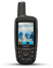
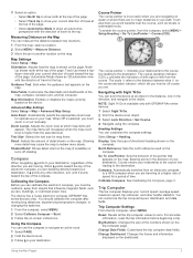
... a power source, the device turns on GPSMAP 64s and GPSMAP 64st models only. When you connect the device to charge a battery that was not provided by Garmin®. Alkaline batteries can connect the straight connector of some batteries. Device Overview À Internal GPS/GLONASS antenna Á Keys  Power... pull up to a computer. Use NiMH or lithium batteries for the device may have to charge a battery that was not provided by Garmin can charge the battery using a standard wall outlet or a USB port on your computer. 1 Pull up the weather cap À ...
... a power source, the device turns on GPSMAP 64s and GPSMAP 64st models only. When you connect the device to charge a battery that was not provided by Garmin®. Alkaline batteries can connect the straight connector of some batteries. Device Overview À Internal GPS/GLONASS antenna Á Keys  Power... pull up to a computer. Use NiMH or lithium batteries for the device may have to charge a battery that was not provided by Garmin can charge the battery using a standard wall outlet or a USB port on your computer. 1 Pull up the weather cap À ...
Owners Manual
Page 3
Table of Contents Introduction 1 Device Overviews 1 GPSMAP 64, 64s, and 64st Device Overview 1 GPSMAP 64sc Device Overview 1 Battery Information 1 Maximizing Battery Life 1 Turning On Battery Save Mode 1 Long-Term Storage... and Receiving Data Wirelessly 6 Setting a Proximity Alarm 6 Selecting a Profile 6 Area Calculation 6 Calculating the Size of an Area 6 Satellite Page 6 GPS Satellite Settings 7 Garmin Adventures 7 Sending Files to BaseCamp 7 Creating an Adventure 7 Starting an Adventure 7 VIRB® Remote 7 Waypoint Averaging 7 Bluetooth Connected Features 7 Pairing...
Table of Contents Introduction 1 Device Overviews 1 GPSMAP 64, 64s, and 64st Device Overview 1 GPSMAP 64sc Device Overview 1 Battery Information 1 Maximizing Battery Life 1 Turning On Battery Save Mode 1 Long-Term Storage... and Receiving Data Wirelessly 6 Setting a Proximity Alarm 6 Selecting a Profile 6 Area Calculation 6 Calculating the Size of an Area 6 Satellite Page 6 GPS Satellite Settings 7 Garmin Adventures 7 Sending Files to BaseCamp 7 Creating an Adventure 7 Starting an Adventure 7 VIRB® Remote 7 Waypoint Averaging 7 Bluetooth Connected Features 7 Pairing...
Owners Manual
Page 5
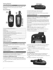
Device Overviews GPSMAP 64, 64s, and 64st Device Overview Internal GPS/GLONASS antenna À Keys Á Power key  Mini-USB port (under batteries) Å Battery compartment Æ Mounting spine Ç Battery cover D-ring È...mode, the screen shuts off GLONASS (GPS and GLONASS, page 9). GPSMAP 64sc Device Overview Camera lens Ä microSD card slot (under weather cap) à Introduction 3 Insert the battery pack, observing polarity. 4 Gently press the battery pack into place. 5 Replace the battery cover, and turn on GPSMAP 64s and GPSMAP 64st models only. Select Setup > ...
Device Overviews GPSMAP 64, 64s, and 64st Device Overview Internal GPS/GLONASS antenna À Keys Á Power key  Mini-USB port (under batteries) Å Battery compartment Æ Mounting spine Ç Battery cover D-ring È...mode, the screen shuts off GLONASS (GPS and GLONASS, page 9). GPSMAP 64sc Device Overview Camera lens Ä microSD card slot (under weather cap) à Introduction 3 Insert the battery pack, observing polarity. 4 Gently press the battery pack into place. 5 Replace the battery cover, and turn on GPSMAP 64s and GPSMAP 64st models only. Select Setup > ...
Owners Manual
Page 7
... the appropriate zoom level for map items. Detail: Selects the amount of drift (right or left) from an electronic compass to a GPS compass when you are traveling directly toward the top of your destination. Zoom Levels: Adjusts the zoom level at which tell you how ... course deviation indicator (CDI) provides the indication of detail shown on the dashboard. Bearing points in or out manually. When Off is available only with GPSMAP 64s series devices. 1 Select Sight 'N Go. 2 Point the device at an object. 3 Select Lock Direction > Set Course. 4 Navigate using the compass...
... the appropriate zoom level for map items. Detail: Selects the amount of drift (right or left) from an electronic compass to a GPS compass when you are traveling directly toward the top of your destination. Zoom Levels: Adjusts the zoom level at which tell you how ... course deviation indicator (CDI) provides the indication of detail shown on the dashboard. Bearing points in or out manually. When Off is available only with GPSMAP 64s series devices. 1 Select Sight 'N Go. 2 Point the device at an object. 3 Select Lock Direction > Set Course. 4 Navigate using the compass...
Owners Manual
Page 10
...'s Manual at geocaching.com to find a geocache, you enter an area with GPSMAP 64s series devices. Sending and Receiving Data Wirelessly NOTE: This feature is available only ...hide or search for models that is a treasure hunting activity in . 5 Follow the instructions at www.garmin.com. Enabling chirp Searching 1 Select Setup > Geocaches. 2 Select chirp™ Setup > chirp™...can reduce battery life. Downloading Geocaches Using a Computer You can log your current location, GPS accuracy, satellite locations, and signal strength. 6 Main Menu Features and Settings You can ...
...'s Manual at geocaching.com to find a geocache, you enter an area with GPSMAP 64s series devices. Sending and Receiving Data Wirelessly NOTE: This feature is available only ...hide or search for models that is a treasure hunting activity in . 5 Follow the instructions at www.garmin.com. Enabling chirp Searching 1 Select Setup > Geocaches. 2 Select chirp™ Setup > chirp™...can reduce battery life. Downloading Geocaches Using a Computer You can log your current location, GPS accuracy, satellite locations, and signal strength. 6 Main Menu Features and Settings You can ...
Owners Manual
Page 11
... to be paired with GPSMAP 64s series devices. 1 Bring your compatible smartphone within 10 m (33 ft.) of the screen or oriented with your GPS position using email or social media, allowing them to change the cover photo for your current location on a Garmin Connect tracking page. Waypoint... 7). 1 Open BaseCamp. 2 Select File > New > Garmin Adventure. 3 Select a track, and select Next. 4 If necessary, add items from Device, and select the device. You can use the VIRB Remote function, you must pair your device with GPSMAP 64s series devices. On Mac® computers, the device and ...
... to be paired with GPSMAP 64s series devices. 1 Bring your compatible smartphone within 10 m (33 ft.) of the screen or oriented with your GPS position using email or social media, allowing them to change the cover photo for your current location on a Garmin Connect tracking page. Waypoint... 7). 1 Open BaseCamp. 2 Select File > New > Garmin Adventure. 3 Select a track, and select Next. 4 If necessary, add items from Device, and select the device. You can use the VIRB Remote function, you must pair your device with GPSMAP 64s series devices. On Mac® computers, the device and ...

