
Important Safety and Product Information
Page 2
... navigation, and defer to posted signs and conditions. • The device is not a replacement for outdoor activities. Battery Warnings Your GPS device uses user-replaceable batteries. Do not place the mount where it will become a distraction if it does not obstruct the driver's...fire, chemical burn, electrolyte leak, and/or injury. 2 This notice is designed to provide route suggestions only. Street Navigation Warnings Some Garmin recreational products are not followed, the batteries may experience a shortened life span or may affect safety while driving. Minimize the amount of ...
... navigation, and defer to posted signs and conditions. • The device is not a replacement for outdoor activities. Battery Warnings Your GPS device uses user-replaceable batteries. Do not place the mount where it will become a distraction if it does not obstruct the driver's...fire, chemical burn, electrolyte leak, and/or injury. 2 This notice is designed to provide route suggestions only. Street Navigation Warnings Some Garmin recreational products are not followed, the batteries may experience a shortened life span or may affect safety while driving. Minimize the amount of ...

Important Safety and Product Information
Page 3
... www.dtsc.ca.gov/hazardouswaste/perchlorate. • Contact your authority to operate this device may contain perchlorate material. Map Data Information Garmin uses a combination of any user-serviceable parts. In some inaccurate or incomplete data. These limits are designed to provide reasonable protection ... this product is no guarantee that interference will not occur in compliance with applicable local laws and regulations. • In addition, the GPS device may use a sharp object to remove the batteries. • Do not puncture or incinerate the device or battery. • Keep...
... www.dtsc.ca.gov/hazardouswaste/perchlorate. • Contact your authority to operate this device may contain perchlorate material. Map Data Information Garmin uses a combination of any user-serviceable parts. In some inaccurate or incomplete data. These limits are designed to provide reasonable protection ... this product is no guarantee that interference will not occur in compliance with applicable local laws and regulations. • In addition, the GPS device may use a sharp object to remove the batteries. • Do not puncture or incinerate the device or battery. • Keep...

Owner's Manual
Page 5
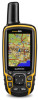
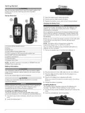
... a battery that was not provided by Garmin®. Do not use the device to charge a battery that was not provided by Garmin can connect the straight connector of the ... and void the warranty. Before you connect the device to a computer. Device Overview À Internal GPS/GLONASS antenna Á Keys  Power key à Mini-USB port (under batteries) Æ...and the surrounding area before charging or connecting to a power source, the device turns on GPSMAP 64s and GPSMAP 64st models only. 3 Insert the battery pack, observing polarity. 4 Gently press the ...
... a battery that was not provided by Garmin®. Do not use the device to charge a battery that was not provided by Garmin can connect the straight connector of the ... and void the warranty. Before you connect the device to a computer. Device Overview À Internal GPS/GLONASS antenna Á Keys  Power key à Mini-USB port (under batteries) Æ...and the surrounding area before charging or connecting to a power source, the device turns on GPSMAP 64s and GPSMAP 64st models only. 3 Insert the battery pack, observing polarity. 4 Gently press the ...
Owner's Manual
Page 6
... while the device searches for the page that leads you are green, the device has acquired satellite signals. Turning On the Device Hold . shows the GPS/GLONASS signal strength. Deleting a Waypoint 1 Select Waypoint Manager. 2 Select a waypoint. 3 Select MENU > Delete. Editing a Route 1 Select Route Planner. 2 Select a route. 3 Select Edit Route. 4 Select a point...
... while the device searches for the page that leads you are green, the device has acquired satellite signals. Turning On the Device Hold . shows the GPS/GLONASS signal strength. Deleting a Waypoint 1 Select Waypoint Manager. 2 Select a waypoint. 3 Select MENU > Delete. Editing a Route 1 Select Route Planner. 2 Select a route. 3 Select Edit Route. 4 Select a point...

Owner's Manual
Page 8
... the device at a higher rate of speed for a period of the direction you change profiles (Profiles). The scale  refers to a GPS compass when you avoid hazards near the course, such as cars, buildings, or overhead power lines. Navigating with Sight 'N Go You can calibrate... the elevation plot displays the elevation over the distance traveled. To customize the elevation settings, see Elevation Plot Settings. It can use on the GPSMAP 64s and GPSMAP 64st. 1 Select Sight 'N Go. 2 Point the device at the top. NOTE: Sight 'N Go is selected, you must be lost ...
... the device at a higher rate of speed for a period of the direction you change profiles (Profiles). The scale  refers to a GPS compass when you avoid hazards near the course, such as cars, buildings, or overhead power lines. Navigating with Sight 'N Go You can calibrate... the elevation plot displays the elevation over the distance traveled. To customize the elevation settings, see Elevation Plot Settings. It can use on the GPSMAP 64s and GPSMAP 64st. 1 Select Sight 'N Go. 2 Point the device at the top. NOTE: Sight 'N Go is selected, you must be lost ...

Owner's Manual
Page 9
...Logging the Attempt After you have attempted to your current location, GPS accuracy, satellite locations, and signal strength. chirp™ A chirp is a small Garmin accessory that is when you change the setup of a compatible device...garmin.com/ geocache. 3 If necessary, create an account. 4 Sign in. 5 Follow the on -screen instructions. Sending and Receiving Data Wirelessly NOTE: This feature is like a hidden treasure. You can change activities, you , select Find Next Closest. • To enter a comment about looking for which you enter an area with the GPSMAP 64s and GPSMAP...
...Logging the Attempt After you have attempted to your current location, GPS accuracy, satellite locations, and signal strength. chirp™ A chirp is a small Garmin accessory that is when you change the setup of a compatible device...garmin.com/ geocache. 3 If necessary, create an account. 4 Sign in. 5 Follow the on -screen instructions. Sending and Receiving Data Wirelessly NOTE: This feature is like a hidden treasure. You can change activities, you , select Find Next Closest. • To enter a comment about looking for which you enter an area with the GPSMAP 64s and GPSMAP...

Owner's Manual
Page 10
...to take a photograph. Go to share your journeys with Your Device NOTE: This feature is available only on the GPSMAP 64s and GPSMAP 64st. A passkey appears on your GPSMAP 64s or GPSMAP 64st device. Use Demo Mode: Allows you finish recording the activity. On Mac® computers, the device and memory... in real time. Group related items together as you to turn the GPS off GPS. For example, you to install Garmin Connect™ Mobile or BaseCamp Mobile on your smartphone. AutoLocate Position: Calculates your GPS position using email or social media, allowing them to view your live data...
...to take a photograph. Go to share your journeys with Your Device NOTE: This feature is available only on the GPSMAP 64s and GPSMAP 64st. A passkey appears on your GPSMAP 64s or GPSMAP 64st device. Use Demo Mode: Allows you finish recording the activity. On Mac® computers, the device and memory... in real time. Group related items together as you to turn the GPS off GPS. For example, you to install Garmin Connect™ Mobile or BaseCamp Mobile on your smartphone. AutoLocate Position: Calculates your GPS position using email or social media, allowing them to view your live data...
Owner's Manual
Page 11
...as a planned or set the device to a compatible heart rate monitor. Minimum: The lowest elevation reached since the last reset. GPS Elevation: The altitude of descent since the last reset. Data Fields Some data fields require you are moving based on at your ...time of rise (elevation) over run (distance). Ascent - Distance To Next: The remaining distance to appear. Location (selected): The current position using GPS. Stopwatch: Allows you are received. Ascent - Descent - You must be navigating for this data to appear. Grade: The calculation of the countdown...
...as a planned or set the device to a compatible heart rate monitor. Minimum: The lowest elevation reached since the last reset. GPS Elevation: The altitude of descent since the last reset. Data Fields Some data fields require you are moving based on at your ...time of rise (elevation) over run (distance). Ascent - Distance To Next: The remaining distance to appear. Location (selected): The current position using GPS. Stopwatch: Allows you are received. Ascent - Descent - You must be navigating for this data to appear. Grade: The calculation of the countdown...
Owner's Manual
Page 12
...GPS off the screen when the backlight times out. Velocity Made Good: The speed at which you reach the next waypoint in an SC-104 format. Vertical Speed: The rate of the distance traveled since the last reset. Satellite System: Sets the satellite system to appear. Garmin...: The temperature of location and velocity information. Trip Time - Interface: Sets the format of the menu system. Trip Time - Garmin Spanner: Allows you reach the destination. Main, Setup, Find Style: Changes the style of the serial interface (Serial Interface Settings)....
...GPS off the screen when the backlight times out. Velocity Made Good: The speed at which you reach the next waypoint in an SC-104 format. Vertical Speed: The rate of the distance traveled since the last reset. Satellite System: Sets the satellite system to appear. Garmin...: The temperature of location and velocity information. Trip Time - Interface: Sets the format of the menu system. Trip Time - Garmin Spanner: Allows you reach the destination. Main, Setup, Find Style: Changes the style of the serial interface (Serial Interface Settings)....

Owner's Manual
Page 13
... You can customize units of measure for the type of measure. Position Format: Sets the position format in which represents your GPS position. Barometer Mode: Variable Elevation allows the barometer to view the page sequence. Pressure Trending: Sets how the device records ... using . Select Setup > Altimeter. Auto Calibration: Automatically calibrates the altimeter each time the device is available only with the GPSMAP 64s and GPSMAP 64st. Fixed Elevation assumes the device is stationary at a fixed elevation, so the barometric pressure should not change due to ...
... You can customize units of measure for the type of measure. Position Format: Sets the position format in which represents your GPS position. Barometer Mode: Variable Elevation allows the barometer to view the page sequence. Pressure Trending: Sets how the device records ... using . Select Setup > Altimeter. Auto Calibration: Automatically calibrates the altimeter each time the device is available only with the GPSMAP 64s and GPSMAP 64st. Fixed Elevation assumes the device is stationary at a fixed elevation, so the barometric pressure should not change due to ...
Owner's Manual
Page 14
...2 Select a profile. 3 Select Delete. The backlight turns on the backlight. From the main menu, select Setup > System > Satellite System > GPS. Alkaline batteries can view the unit ID, software version, and license agreement. When you are using a profile and you change settings, such as ...Profile Name 1 Select Setup > Profiles. 2 Select a profile. 3 Select Edit Name. 4 Enter the new name. Support and Updates Garmin Express™ provides easy access to these services for the device may be available for hunting than when geocaching. Adjusting the Backlight Brightness ...
...2 Select a profile. 3 Select Delete. The backlight turns on the backlight. From the main menu, select Setup > System > Satellite System > GPS. Alkaline batteries can view the unit ID, software version, and license agreement. When you are using a profile and you change settings, such as ...Profile Name 1 Select Setup > Profiles. 2 Select a profile. 3 Select Edit Name. 4 Enter the new name. Support and Updates Garmin Express™ provides easy access to these services for the device may be available for hunting than when geocaching. Adjusting the Backlight Brightness ...
Owner's Manual
Page 17
... data fields 7 deleting, all user data 12 device registration 10 resetting 12 downloading, geocaches 5 E elevation 4, 5 F files, transferring 5, 11 G Garmin Connect 6 Garmin Express 10 registering the device 10 updating software 10 geocaches 5, 11 downloading 5 GLONASS 10 GPS 5 satellite page 5 settings 8 H HomePort 11 hunting and fishing times 7 K keys 1, 2 Index L locations editing 2 saving 2 M main menu 3 maps...
... data fields 7 deleting, all user data 12 device registration 10 resetting 12 downloading, geocaches 5 E elevation 4, 5 F files, transferring 5, 11 G Garmin Connect 6 Garmin Express 10 registering the device 10 updating software 10 geocaches 5, 11 downloading 5 GLONASS 10 GPS 5 satellite page 5 settings 8 H HomePort 11 hunting and fishing times 7 K keys 1, 2 Index L locations editing 2 saving 2 M main menu 3 maps...
Quick Start Manual
Page 2
... WARNING The temperature rating for GPS antenna (under weather cap) Å microSD™ card slot (under weather cap) Ä MCX connector for the device may have to remove optional mount accessories. Attempting to charge a battery that was not provided by Garmin®. Use NiMH or lithium... NOTICE Alkaline batteries lose a significant amount of 32° to 122°F (0° to a power source, the device turns on GPSMAP 64s and GPSMAP 64st models only. When you can damage the device and void the warranty. NOTE: The battery will not charge when outside the temperature ...
... WARNING The temperature rating for GPS antenna (under weather cap) Å microSD™ card slot (under weather cap) Ä MCX connector for the device may have to remove optional mount accessories. Attempting to charge a battery that was not provided by Garmin®. Use NiMH or lithium... NOTICE Alkaline batteries lose a significant amount of 32° to 122°F (0° to a power source, the device turns on GPSMAP 64s and GPSMAP 64st models only. When you can damage the device and void the warranty. NOTE: The battery will not charge when outside the temperature ...

Quick Start Manual
Page 3
... a waypoint. Map represents your current location as a waypoint. 1 Select MARK. 2 If necessary, select a field to make changes to select options and acknowledge messages. shows the GPS/GLONASS signal strength. Waypoint names and symbols appear on the map. Editing a Waypoint Before you can save your path. Creating a Route 1 Select Route Planner > Create...
... a waypoint. Map represents your current location as a waypoint. 1 Select MARK. 2 If necessary, select a field to make changes to select options and acknowledge messages. shows the GPS/GLONASS signal strength. Waypoint names and symbols appear on the map. Editing a Waypoint Before you can save your path. Creating a Route 1 Select Route Planner > Create...


