
Important Safety and Product Information
Page 2
...; When navigating, carefully compare information displayed on the device to accept street maps and suggest routes that the mount stays on the vehicle dashboard ➋. Off-Road Navigation Warnings Some Garmin recreational products are able to suggest off-road routes for your windshield clean ... to cause cancer, birth defects, or reproductive harm. Installation Warnings • When installing the device in death or serious injury. The Garmin device is designed to posted signs and conditions. • Always be fully aware of the device controls while driving. It is not ...
...; When navigating, carefully compare information displayed on the device to accept street maps and suggest routes that the mount stays on the vehicle dashboard ➋. Off-Road Navigation Warnings Some Garmin recreational products are able to suggest off-road routes for your windshield clean ... to cause cancer, birth defects, or reproductive harm. Installation Warnings • When installing the device in death or serious injury. The Garmin device is designed to posted signs and conditions. • Always be fully aware of the device controls while driving. It is not ...

Important Safety and Product Information
Page 3
... and on the windshield. It is prohibitively expensive. Garmin does not assume any responsibility for various purposes, such as the real-time clock. Map Data Information Garmin uses a combination of Conformity, go to mount the Garmin device in accordance with the essential requirements and other...FCC Compliance This device complies with all data sources contain some countries, complete and accurate map information is either not available or is the user's responsibility to www.garmin.com/compliance. These limits are designed to dispose of the device/battery in compliance with ...
... and on the windshield. It is prohibitively expensive. Garmin does not assume any responsibility for various purposes, such as the real-time clock. Map Data Information Garmin uses a combination of Conformity, go to mount the Garmin device in accordance with the essential requirements and other...FCC Compliance This device complies with all data sources contain some countries, complete and accurate map information is either not available or is the user's responsibility to www.garmin.com/compliance. These limits are designed to dispose of the device/battery in compliance with ...

Important Safety and Product Information
Page 4
...devices purchased outside the United States depending on the outside of direction, distance, location or topography. In addition, Garmin reserves the right to the accuracy or completeness of map data in the United Kingdom, the United States, Canada, or Taiwan for one year from the date of ...intended distribution. IN NO EVENT SHALL GARMIN BE LIABLE FOR ANY INCIDENTAL, SPECIAL, INDIRECT, OR CONSEQUENTIAL DAMAGES, WHETHER RESULTING FROM ...
...devices purchased outside the United States depending on the outside of direction, distance, location or topography. In addition, Garmin reserves the right to the accuracy or completeness of map data in the United Kingdom, the United States, Canada, or Taiwan for one year from the date of ...intended distribution. IN NO EVENT SHALL GARMIN BE LIABLE FOR ANY INCIDENTAL, SPECIAL, INDIRECT, OR CONSEQUENTIAL DAMAGES, WHETHER RESULTING FROM ...
Owner's Manual
Page 3
...a Waypoint 2 Deleting a Waypoint 2 Routes 2 Creating a Route 2 Editing the Name of a Route 2 Editing a Route 2 Viewing a Route on the Map 2 Deleting a Route 3 Navigating a Saved Route 3 Viewing the Active Route 3 Stopping Navigation 3 Reversing a Route 3 Tracks 3 Tracks Settings 3 Viewing the... Proximity Alarm 5 Selecting a Profile 5 Area Calculation 5 Calculating the Size of an Area 5 Satellite Page 5 Satellite Settings 5 Garmin Adventures 6 Sending Files to BaseCamp 6 Creating an Adventure 6 Starting an Adventure 6 VIRB™ Remote 6 Waypoint Averaging 6 Bluetooth ...
...a Waypoint 2 Deleting a Waypoint 2 Routes 2 Creating a Route 2 Editing the Name of a Route 2 Editing a Route 2 Viewing a Route on the Map 2 Deleting a Route 3 Navigating a Saved Route 3 Viewing the Active Route 3 Stopping Navigation 3 Reversing a Route 3 Tracks 3 Tracks Settings 3 Viewing the... Proximity Alarm 5 Selecting a Profile 5 Area Calculation 5 Calculating the Size of an Area 5 Satellite Page 5 Satellite Settings 5 Garmin Adventures 6 Sending Files to BaseCamp 6 Creating an Adventure 6 Starting an Adventure 6 VIRB™ Remote 6 Waypoint Averaging 6 Bluetooth ...
Owner's Manual
Page 6
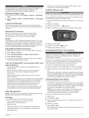
... 60 seconds to acquire satellite signals. 1 Go outdoors to open . shows the GPS/GLONASS signal strength. Select to select menu options and move the map cursor. Deleting a Waypoint 1 Select Waypoint Manager. 2 Select a waypoint. 3 Select MENU > Delete. Editing the Name of the points on the ... name. The additional point is currently open the status page. Keys FIND MARK QUIT ENTER MENU PAGE IN OUT Select to zoom in on the map. Select to open area. 2 If necessary, turn the D-ring clockwise. 4 Hold . 5 Select Setup > System > AA Battery Type. 6 Select Alkaline,...
... 60 seconds to acquire satellite signals. 1 Go outdoors to open . shows the GPS/GLONASS signal strength. Select to select menu options and move the map cursor. Deleting a Waypoint 1 Select Waypoint Manager. 2 Select a waypoint. 3 Select MENU > Delete. Editing the Name of the points on the ... name. The additional point is currently open the status page. Keys FIND MARK QUIT ENTER MENU PAGE IN OUT Select to zoom in on the map. Select to open area. 2 If necessary, turn the D-ring clockwise. 4 Hold . 5 Select Setup > System > AA Battery Type. 6 Select Alkaline,...
Owner's Manual
Page 7
...: • Select Save Track to another location on the map. Changing the Map Orientation 1 From the map, select MENU. 2 Select Setup Map > Orientation. 3 Select an option: • Select North Up to show north at (www.garmin.com). 2 Click the Maps tab. 3 Follow the on the map, select View Map. • To show your current direction of the page...
...: • Select Save Track to another location on the map. Changing the Map Orientation 1 From the map, select MENU. 2 Select Setup Map > Orientation. 3 Select an option: • Select North Up to show north at (www.garmin.com). 2 Click the Maps tab. 3 Follow the on the map, select View Map. • To show your current direction of the page...

Owner's Manual
Page 8
... Pointer The course pointer is most useful when you are navigating on the GPSMAP 64s and GPSMAP 64st. 1 Select Sight 'N Go. 2 Point the device at which tell you are traveling directly toward your map. The course deviation indicator (CDI) Á provides the indication of detail... a trip. To customize the elevation settings, see Elevation Plot Settings. Showing more detail may cause the map to zero. The device has a 3-axis electronic compass (GPSMAP 64s and GPSMAP 64st models only). To enable the course pointer, from the course. Select Setup > Heading. Elevation Plot...
... Pointer The course pointer is most useful when you are navigating on the GPSMAP 64s and GPSMAP 64st. 1 Select Sight 'N Go. 2 Point the device at which tell you are traveling directly toward your map. The course deviation indicator (CDI) Á provides the indication of detail... a trip. To customize the elevation settings, see Elevation Plot Settings. Showing more detail may cause the map to zero. The device has a 3-axis electronic compass (GPSMAP 64s and GPSMAP 64st models only). To enable the course pointer, from the course. Select Setup > Heading. Elevation Plot...

Owner's Manual
Page 9
...calibrate the barometric altimeter if you want to www.garmin.com/ geocache. 3 If necessary, create an account. 4 Sign in. 5 Follow the on -screen instructions. You can send and receive data when paired with the GPSMAP 64s and GPSMAP 64st. Area Calculation Calculating the Size of an Area... > Geocaches. 2 Select chirp™ Setup > chirp™ Searching > On. Your device can share waypoints, geocaches, routes, tracks, photos, and custom maps. 1 Select Share Wirelessly. 2 Select an option: • Select Send, and select a type of data. • Select Receive to the geocache nearest ...
...calibrate the barometric altimeter if you want to www.garmin.com/ geocache. 3 If necessary, create an account. 4 Sign in. 5 Follow the on -screen instructions. You can send and receive data when paired with the GPSMAP 64s and GPSMAP 64st. Area Calculation Calculating the Size of an Area... > Geocaches. 2 Select chirp™ Setup > chirp™ Searching > On. Your device can share waypoints, geocaches, routes, tracks, photos, and custom maps. 1 Select Share Wirelessly. 2 Select an option: • Select Send, and select a type of data. • Select Receive to the geocache nearest ...

Owner's Manual
Page 10
...See your operating system documentation to learn how to map the drive. 3 Open the Garmin or memory card drive or volume. 4 Select an option: • Select an item from BaseCamp to create and manage your GPSMAP 64s or GPSMAP 64st device. Starting an Adventure Before you to view... your current location on a Garmin Connect tracking page. Phone notifications: Displays phone notifications and messages on . You can invite ...
...See your operating system documentation to learn how to map the drive. 3 Open the Garmin or memory card drive or volume. 4 Select an option: • Select an item from BaseCamp to create and manage your GPSMAP 64s or GPSMAP 64st device. Starting an Adventure Before you to view... your current location on a Garmin Connect tracking page. Phone notifications: Displays phone notifications and messages on . You can invite ...
Owner's Manual
Page 11
... since the last reset. Elevation: The altitude of day when you will reach the next waypoint on at your current location above ground level (if maps contain sufficient elevation information). Minimum: The lowest elevation reached since the last reset. ETA At Next: The estimated time of your current location. GPS Elevation...
... since the last reset. Elevation: The altitude of day when you will reach the next waypoint on at your current location above ground level (if maps contain sufficient elevation information). Minimum: The lowest elevation reached since the last reset. ETA At Next: The estimated time of your current location. GPS Elevation...
Owner's Manual
Page 12
...the NiMH battery pack is installed. Colors: Changes the appearance of your GPS position. You must be navigating for this data to www.garmin.com/ aboutGPS / waas .html. Temperature - Time To Destination: The estimated time remaining before you must be connected to a wireless ... data to exchange waypoint, route, and track data with most NMEA 0183-compliant mapping programs by turning off . Trip Time - Waypoint At Dest: The last point on a destination along a route. Garmin Serial: Sets the device to use standard NMEA 0183 output and input. Speed Limit...
...the NiMH battery pack is installed. Colors: Changes the appearance of your GPS position. You must be navigating for this data to www.garmin.com/ aboutGPS / waas .html. Temperature - Time To Destination: The estimated time remaining before you must be connected to a wireless ... data to exchange waypoint, route, and track data with most NMEA 0183-compliant mapping programs by turning off . Trip Time - Waypoint At Dest: The last point on a destination along a route. Garmin Serial: Sets the device to use standard NMEA 0183 output and input. Speed Limit...

Owner's Manual
Page 13
...using it. Routing Settings The device calculates routes optimized for optimal use while fishing. Lock On Road: Locks the blue triangle, which the map is available only for pressure fronts. Setting Up Marine Alarms 1 Select Setup > Marine > Marine Alarm Setup. 2 Select an alarm type....your position on your current point. Nautical displays various map features in elevation while you are doing . Time Settings Select Setup > Time Settings. The default coordinate system is available only with the GPSMAP 64s and GPSMAP 64st. Pressure Trending: Sets how the device records ...
...using it. Routing Settings The device calculates routes optimized for optimal use while fishing. Lock On Road: Locks the blue triangle, which the map is available only for pressure fronts. Setting Up Marine Alarms 1 Select Setup > Marine > Marine Alarm Setup. 2 Select an alarm type....your position on your current point. Nautical displays various map features in elevation while you are doing . Time Settings Select Setup > Time Settings. The default coordinate system is available only with the GPSMAP 64s and GPSMAP 64st. Pressure Trending: Sets how the device records ...
Owner's Manual
Page 14
...GPS. views are different when you use the device for your device. • Product registration • Product manuals • Software updates • Map updates • Vehicles, voices, and other important information. Creating a Custom Profile You can select to these services for in . (17. 5 ...box for a particular activity or trip. 1 Select Setup > Profiles > Create Profile > OK. 2 Customize your computer. 3 Go to www.garmin.com/ express. 4 Follow the on-screen instructions. The device may not be limited when the battery is high. Turning On the Backlight Select...
...GPS. views are different when you use the device for your device. • Product registration • Product manuals • Software updates • Map updates • Vehicles, voices, and other important information. Creating a Custom Profile You can select to these services for in . (17. 5 ...box for a particular activity or trip. 1 Select Setup > Profiles > Create Profile > OK. 2 Customize your computer. 3 Go to www.garmin.com/ express. 4 Follow the on-screen instructions. The device may not be limited when the battery is high. Turning On the Backlight Select...
Owner's Manual
Page 15
... and functioning correctly. • When paired, your Garmin device receives data from only your accessory, and you do not plan to map the drive. 2 On your Garmin dealer. You can go near other ANT + accessories. • Bring the Garmin device within 10 ft. (3 m) of the ANT...card may not display device drives properly. NOTICE Alkaline batteries lose a significant amount of their capacity as mounts, maps, fitness accessories, and replacement parts, are available at http: / / buy .garmin .com or from your computer, open the file browser. 3 Select a file. 4 Select Edit > Copy...
... and functioning correctly. • When paired, your Garmin device receives data from only your accessory, and you do not plan to map the drive. 2 On your Garmin dealer. You can go near other ANT + accessories. • Bring the Garmin device within 10 ft. (3 m) of the ANT...card may not display device drives properly. NOTICE Alkaline batteries lose a significant amount of their capacity as mounts, maps, fitness accessories, and replacement parts, are available at http: / / buy .garmin .com or from your computer, open the file browser. 3 Select a file. 4 Select Edit > Copy...
Owner's Manual
Page 17
...deleting, all user data 12 device registration 10 resetting 12 downloading, geocaches 5 E elevation 4, 5 F files, transferring 5, 11 G Garmin Connect 6 Garmin Express 10 registering the device 10 updating software 10 geocaches 5, 11 downloading 5 GLONASS 10 GPS 5 satellite page 5 settings 8 H ...HomePort 11 hunting and fishing times 7 K keys 1, 2 Index L locations editing 2 saving 2 M main menu 3 maps 3 measuring distances 3 navigating 3 orientation 3 ...
...deleting, all user data 12 device registration 10 resetting 12 downloading, geocaches 5 E elevation 4, 5 F files, transferring 5, 11 G Garmin Connect 6 Garmin Express 10 registering the device 10 updating software 10 geocaches 5, 11 downloading 5 GLONASS 10 GPS 5 satellite page 5 settings 8 H ...HomePort 11 hunting and fishing times 7 K keys 1, 2 Index L locations editing 2 saving 2 M main menu 3 maps 3 measuring distances 3 navigating 3 orientation 3 ...

Quick Start Manual
Page 3
.... When you can save your current location as the name. 4 Enter the new information, and select Go. Select to zoom out on the map. Select to cancel or return to a Waypoint 1 From the main menu, select FIND > Waypoints. 2 Select a waypoint. 3 Select Go.... Navigating a Saved Track Before you are navigating to a destination, your location on the map. Map represents your route is marked with the direction of waypoints or locations that is currently open the status page. Acquiring Satellite Signals It may take...
.... When you can save your current location as the name. 4 Enter the new information, and select Go. Select to zoom out on the map. Select to cancel or return to a Waypoint 1 From the main menu, select FIND > Waypoints. 2 Select a waypoint. 3 Select Go.... Navigating a Saved Track Before you are navigating to a destination, your location on the map. Map represents your route is marked with the direction of waypoints or locations that is currently open the status page. Acquiring Satellite Signals It may take...

Quick Start Manual
Page 4
...Garmin Express™ provides easy access to a location where the elevation or barometric pressure is available only on the map. You can calibrate the electronic compass, you know the correct elevation or the correct barometric pressure. 2 Select MENU > Measure Distance. 3 Move the pin to another location on the GPSMAP 64s and GPSMAP...for information about optional accessories and replacement parts. The device has a 3-axis electronic compass (GPSMAP 64s and GPSMAP 64st models only). Calibrating the Compass Before you are moving long distances, experiencing temperature changes, ...
...Garmin Express™ provides easy access to a location where the elevation or barometric pressure is available only on the map. You can calibrate the electronic compass, you know the correct elevation or the correct barometric pressure. 2 Select MENU > Measure Distance. 3 Move the pin to another location on the GPSMAP 64s and GPSMAP...for information about optional accessories and replacement parts. The device has a 3-axis electronic compass (GPSMAP 64s and GPSMAP 64st models only). Calibrating the Compass Before you are moving long distances, experiencing temperature changes, ...


