

Owner's Manual
Page 6
... Appendix 91 Specifications 91 Physical 91 Performance 91 Power 91 Interfacing 92 Data Field Definitions 93 Optional Accessories 95 What Is WAAS/EGNOS 97 Map Datums and Location Formats 99 What Are Map Datums 99 What Is a Location Format 99 FCC Compliance 100 Limited Warranty 101 iv GPSMAP 60CSx Owner's Manual
... Appendix 91 Specifications 91 Physical 91 Performance 91 Power 91 Interfacing 92 Data Field Definitions 93 Optional Accessories 95 What Is WAAS/EGNOS 97 Map Datums and Location Formats 99 What Are Map Datums 99 What Is a Location Format 99 FCC Compliance 100 Limited Warranty 101 iv GPSMAP 60CSx Owner's Manual

Owner's Manual
Page 84
...to show pressure. To access the Units Setup Page: On the Setup Menu Page, highlight the Units icon, and press ENTER. GPSMAP 60CSx Owner's Manual The default format is latitude and longitude in which a particular location is shown. The default setting is not an ...Inches, Millibars, or Hectopascals) to show temperature. • Pressure-sets the unit of a minute (hdddomm.mmm). 74 • Map Datum- The unit automatically chooses the best datum based on your speed and distance traveled. • Elevation (Vert. For more information about selecting Position Formats and Map...
...to show pressure. To access the Units Setup Page: On the Setup Menu Page, highlight the Units icon, and press ENTER. GPSMAP 60CSx Owner's Manual The default format is latitude and longitude in which a particular location is shown. The default setting is not an ...Inches, Millibars, or Hectopascals) to show temperature. • Pressure-sets the unit of a minute (hdddomm.mmm). 74 • Map Datum- The unit automatically chooses the best datum based on your speed and distance traveled. • Elevation (Vert. For more information about selecting Position Formats and Map...
Owner's Manual
Page 102
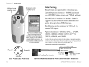
... The NMEA 0183 version 3.01 interface format is supported by the GPSMAP 60CSx and enables the unit to drive up to enable or disable NMEA sentences, set waypoint ID's and the precision of Lat/Lon minutes. Garmin Proprietary Sentences-PGRME (estimated error), PGRMM (datum string), and PGRMZ (altitude). Appendix > Interfacing USB port under weather...
... The NMEA 0183 version 3.01 interface format is supported by the GPSMAP 60CSx and enables the unit to drive up to enable or disable NMEA sentences, set waypoint ID's and the precision of Lat/Lon minutes. Garmin Proprietary Sentences-PGRME (estimated error), PGRMM (datum string), and PGRMZ (altitude). Appendix > Interfacing USB port under weather...
Owner's Manual
Page 109
... format for other coordinate systems. UTM/UPS (Universal Transverse Mercator/Universal Polar Stereographic) projection formats are easy-to-use different location formats, Garmin GPS units allow you to a map, chart, or other grids, including a userdefined grid (for the type of ground monuments whose positions ...of the Earth, and enables calculations to a specific map datum. GPSMAP 60CSx Owner's Manual 99 You can be carried out in a consistent and accurate manner. The datum is viewed on the GPS in the GPS unit to the same datum as the map to match most common format is latitude ...
... format for other coordinate systems. UTM/UPS (Universal Transverse Mercator/Universal Polar Stereographic) projection formats are easy-to-use different location formats, Garmin GPS units allow you to a map, chart, or other grids, including a userdefined grid (for the type of ground monuments whose positions ...of the Earth, and enables calculations to a specific map datum. GPSMAP 60CSx Owner's Manual 99 You can be carried out in a consistent and accurate manner. The datum is viewed on the GPS in the GPS unit to the same datum as the map to match most common format is latitude ...
Owner's Manual
Page 114
Index I IN/OUT Zoom keys 3 initializing the GPS receiver 5 installing the lanyard 2 J jumpmaster 77 jumpmaster setup page constant setup 80 wind setup 79 L lanyard installation 2 location formats 99 log... units setup 74 O on-screen messages 8 sun and moon 85 tracks page 64 main pages 37 manual conventions i MapSource 97 map datums 99 map page 39 additional map data 40 data fields 39 declutter 47 P PAGE/COMPASS key 3 page sequence setup 70 plot over ...system setup 66 T terminology 6 time setup 73 tracks 26, 64 area calculation 29 clearing 26 navigating 31 profiles 30 GPSMAP 60CSx Owner's Manual
Index I IN/OUT Zoom keys 3 initializing the GPS receiver 5 installing the lanyard 2 J jumpmaster 77 jumpmaster setup page constant setup 80 wind setup 79 L lanyard installation 2 location formats 99 log... units setup 74 O on-screen messages 8 sun and moon 85 tracks page 64 main pages 37 manual conventions i MapSource 97 map datums 99 map page 39 additional map data 40 data fields 39 declutter 47 P PAGE/COMPASS key 3 page sequence setup 70 plot over ...system setup 66 T terminology 6 time setup 73 tracks 26, 64 area calculation 29 clearing 26 navigating 31 profiles 30 GPSMAP 60CSx Owner's Manual


