Quick Start Guide
Page 1
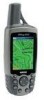
... display the list of the Owner's Manual (page 17). Use the ROCKER key to select the "Go To" button at the top of the Owner's Manual for the Map Page. 3. Waypoints ... select "Stop Navigation" and press ENTER. A Printed in Taiwan ® GPSMAP 60 map navigator quick start guide GPS Antenna Power Key LCD Display In/Out (Zoom) Keys Page Key Rocker Key... "Bearing Pointer" and a "Compass Ring." Compass Page Map Page Trip Computer © Copyright 2004 Garmin Ltd. Waypoint Information Page Using the on-screen buttons allows you toward the waypoint. The Bearing Pointer indicates...
... display the list of the Owner's Manual (page 17). Use the ROCKER key to select the "Go To" button at the top of the Owner's Manual for the Map Page. 3. Waypoints ... select "Stop Navigation" and press ENTER. A Printed in Taiwan ® GPSMAP 60 map navigator quick start guide GPS Antenna Power Key LCD Display In/Out (Zoom) Keys Page Key Rocker Key... "Bearing Pointer" and a "Compass Ring." Compass Page Map Page Trip Computer © Copyright 2004 Garmin Ltd. Waypoint Information Page Using the on-screen buttons allows you toward the waypoint. The Bearing Pointer indicates...
Quick Start Guide
Page 2
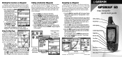
...location on two "AA" batteries (not included), which are removed. Battery Compartment 4. Satellite Page Displays your direction of the Owner's Manual to view the Find Menu Page. If so, you get a "Lost Satellite Signal" message, move the map panning arrow. ...Satellite Page - Status Bar 3D GPS indicator Received Satellite icon Position Bug indicates your direction of movement Satellite Signal Strength Bars Satellite Page Options • Turn GPS Off • Orient display to mark your current location). With the GPSmap 60 On, press and release the...
...location on two "AA" batteries (not included), which are removed. Battery Compartment 4. Satellite Page Displays your direction of the Owner's Manual to view the Find Menu Page. If so, you get a "Lost Satellite Signal" message, move the map panning arrow. ...Satellite Page - Status Bar 3D GPS indicator Received Satellite icon Position Bug indicates your direction of movement Satellite Signal Strength Bars Satellite Page Options • Turn GPS Off • Orient display to mark your current location). With the GPSmap 60 On, press and release the...

Owner's Manual
Page 1
GPSMAP® 60CS with sensors and maps owner's manual
GPSMAP® 60CS with sensors and maps owner's manual

Owner's Manual
Page 2
... notice and provided further that any unauthorized commercial distribution of this manual or any person or organization of this manual onto a hard drive or other Garmin products. Garmin hereby grants permission to make changes in Taiwan Garmin®, MapSource®, BlueChart®, TracBack® and GPSmap® are registered trademarks and AutoLocate™ is strictly prohibited...
... notice and provided further that any unauthorized commercial distribution of this manual or any person or organization of this manual onto a hard drive or other Garmin products. Garmin hereby grants permission to make changes in Taiwan Garmin®, MapSource®, BlueChart®, TracBack® and GPSmap® are registered trademarks and AutoLocate™ is strictly prohibited...
Owner's Manual
Page 3
...Garmin GPSmap 60CS color map handheld navigation system. Friday, 8 am - 5 pm Central Time; Be sure to record the serial number in the U.S.A. Serial Number: Product Registration Connect to re-register using the unit control buttons, initializing the receiver, etc. This Owner's Manual and Reference Guide is located in a safe place or attach a photocopy inside the manual. GPS... Navigation - Also included in this area to keep your GPSmap 60CS. at...
...Garmin GPSmap 60CS color map handheld navigation system. Friday, 8 am - 5 pm Central Time; Be sure to record the serial number in the U.S.A. Serial Number: Product Registration Connect to re-register using the unit control buttons, initializing the receiver, etc. This Owner's Manual and Reference Guide is located in a safe place or attach a photocopy inside the manual. GPS... Navigation - Also included in this area to keep your GPSmap 60CS. at...

Owner's Manual
Page 6
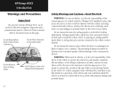
... aid to actual use of this Owner's Manual - THIS PRODUCT IS INTENDED TO BE USED ONLY AS A NAVIGATIONAL AID AND MUST NOT BE USED FOR ANY PURPOSE REQUIRING PRECISE MEASUREMENT OF DIRECTION, DISTANCE, LOCATION OR TOPOGRAPHY. GPSmap 60CS Introduction Warnings and Precautions CAUTION: Use the GPSmap™ 60CS at your own risk. and thoroughly practice...
... aid to actual use of this Owner's Manual - THIS PRODUCT IS INTENDED TO BE USED ONLY AS A NAVIGATIONAL AID AND MUST NOT BE USED FOR ANY PURPOSE REQUIRING PRECISE MEASUREMENT OF DIRECTION, DISTANCE, LOCATION OR TOPOGRAPHY. GPSmap 60CS Introduction Warnings and Precautions CAUTION: Use the GPSmap™ 60CS at your own risk. and thoroughly practice...
Owner's Manual
Page 8
... and Precautions Important Because the Garmin GPSmap 60CS can propel objects in their path towards the vehicle driver or passengers causing possible injury. Do not mount the unit over airbag panels or in a ... be used in vehicles, it in the vehicle owner's manual. WARNING: For use in vehicles, it is the sole responsibility of the owner/operator of a vehicle with a GPSmap 60CS installed to pay full attention to airbag safety precautions contained in a collision. Failure by Garmin is Blocked Do Not Place Unsecured on this page. WARNING...
... and Precautions Important Because the Garmin GPSmap 60CS can propel objects in their path towards the vehicle driver or passengers causing possible injury. Do not mount the unit over airbag panels or in a ... be used in vehicles, it in the vehicle owner's manual. WARNING: For use in vehicles, it is the sole responsibility of the owner/operator of a vehicle with a GPSmap 60CS installed to pay full attention to airbag safety precautions contained in a collision. Failure by Garmin is Blocked Do Not Place Unsecured on this page. WARNING...

Owner's Manual
Page 25
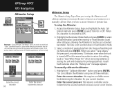
...instructions.) Setting the Speed and Time for navigation. 2. Sometimes, however, when you turn the Compass On, the GPSmap 60CS overrides the Compass and uses the GPS receiver to conserve batteries. A Compass Icon displays in use the numeric keypad to get an accurate Electronic Compass reading. ... ENTER to display the Setup Menu. 2. GPSmap 60CS GPS Navigation The Compass Page Electronic Compass "On" and "Off" messages Speed Setting Time Delay Options Heading Setup Page with Compass Switch Options 15 The Electronic Compass When you manually turn the Compass Off, it stays off ...
...instructions.) Setting the Speed and Time for navigation. 2. Sometimes, however, when you turn the Compass On, the GPSmap 60CS overrides the Compass and uses the GPS receiver to conserve batteries. A Compass Icon displays in use the numeric keypad to get an accurate Electronic Compass reading. ... ENTER to display the Setup Menu. 2. GPSmap 60CS GPS Navigation The Compass Page Electronic Compass "On" and "Off" messages Speed Setting Time Delay Options Heading Setup Page with Compass Switch Options 15 The Electronic Compass When you manually turn the Compass Off, it stays off ...

Owner's Manual
Page 35
Calibrate Altimeter Because the GPSmap 60CS relies on the Barometric pressure to determine the elevation and the pressure at your current location, use the default GPS elevation. 4. high- If you can be programmed to open the data field Options Menu. 2. Data Fields Two data...of the Appendix for defintions.) To program a data field: 1. GPSmap 60CS GPS Navigation The Altimeter Page Calibrate using Elevation Calibrate using Pressure Altimeter Data Fields Data Field Options List 25 To manually calibrate the altimeter: 1. Use the ROCKER key to move Up or Down the ...
Calibrate Altimeter Because the GPSmap 60CS relies on the Barometric pressure to determine the elevation and the pressure at your current location, use the default GPS elevation. 4. high- If you can be programmed to open the data field Options Menu. 2. Data Fields Two data...of the Appendix for defintions.) To program a data field: 1. GPSmap 60CS GPS Navigation The Altimeter Page Calibrate using Elevation Calibrate using Pressure Altimeter Data Fields Data Field Options List 25 To manually calibrate the altimeter: 1. Use the ROCKER key to move Up or Down the ...

Owner's Manual
Page 60
...the last being your destination. Before each turn . The routes use roads. GPSmap 60CS GPS Navigation Using Routes Direct Line Navigation Go To (Distance) Navigation from Waypoint to Waypoint Auto Routing 50 Manual Routing Navigation using Existing Roadways Methods of navigating to a destination: • When... you activate the "Go To" button on the Information Page for a User Waypoint or other Find Menu items, the GPSmap 60CS creates a straight path (point...
...the last being your destination. Before each turn . The routes use roads. GPSmap 60CS GPS Navigation Using Routes Direct Line Navigation Go To (Distance) Navigation from Waypoint to Waypoint Auto Routing 50 Manual Routing Navigation using Existing Roadways Methods of navigating to a destination: • When... you activate the "Go To" button on the Information Page for a User Waypoint or other Find Menu items, the GPSmap 60CS creates a straight path (point...

Owner's Manual
Page 62
... the Main Menu and press the MENU key to display the Options Menu. 2. Select "Yes" and press ENTER. GPSmap 60CS GPS Navigation Using Routes Saved Routes Options Route Options To delete the route: 1. Select "Auto,""Manual" or "Distance." 52 To select a method for a route: 1. Highlight the Route Leg Transition field and press ENTER...
... the Main Menu and press the MENU key to display the Options Menu. 2. Select "Yes" and press ENTER. GPSmap 60CS GPS Navigation Using Routes Saved Routes Options Route Options To delete the route: 1. Select "Auto,""Manual" or "Distance." 52 To select a method for a route: 1. Highlight the Route Leg Transition field and press ENTER...
Owner's Manual
Page 76
... to determine the accurate barometric pressure at the next start-up. Install fresh batteries when the "Battery Low" message appears. To manually calibrate the Altimeter: 1. Highlight the Barometer Mode field and press ENTER to select Variable Elevation (used when moving) or Fixed...for satellite acquisition at your current location. When you may need to function as a standard barometer). Trip data is turned off. GPSmap 60CS GPS Navigation Altimeter Setup Important - If you have accurate elevation or pressure data. For this reason be certain to switch back to "...
... to determine the accurate barometric pressure at the next start-up. Install fresh batteries when the "Battery Low" message appears. To manually calibrate the Altimeter: 1. Highlight the Barometer Mode field and press ENTER to select Variable Elevation (used when moving) or Fixed...for satellite acquisition at your current location. When you may need to function as a standard barometer). Trip data is turned off. GPSmap 60CS GPS Navigation Altimeter Setup Important - If you have accurate elevation or pressure data. For this reason be certain to switch back to "...
Owner's Manual
Page 88
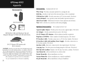
GPSmap 60CS Appendix Accessories Belt Clip Assembly USB Interface Cable and MapSource Trip and Waypoint Manager CD-ROM with the Unit) Cigarette Lighter Adapter - Belt Clip - Abbreviated overview of accessories on the unit packaging. Note: Refer to your Garmin Dealer or website for ... (Not shown) Owner's Manual - Provides connection to a PC for use with Garmin Products. See your Garmin Product and void the terms of the unit. (Not shown) Belt Clip with Carabiner- GA 27C Remote GPS Antenna with MCX Connector CAUTION: Garmin Accessories have not necessarily been...
GPSmap 60CS Appendix Accessories Belt Clip Assembly USB Interface Cable and MapSource Trip and Waypoint Manager CD-ROM with the Unit) Cigarette Lighter Adapter - Belt Clip - Abbreviated overview of accessories on the unit packaging. Note: Refer to your Garmin Dealer or website for ... (Not shown) Owner's Manual - Provides connection to a PC for use with Garmin Products. See your Garmin Product and void the terms of the unit. (Not shown) Belt Clip with Carabiner- GA 27C Remote GPS Antenna with MCX Connector CAUTION: Garmin Accessories have not necessarily been...
Owner's Manual
Page 98
... identified by adding them to provide your unit with the GPSmap 60CS. 88 Transferring MapSource Map Data If you have purchased a Garmin MapSource CD-ROM mapping program you leave a City Select area for storage and safety backup of MapSource data in the MapSource User's Manual. Follow instructions for details on which maps work with...
... identified by adding them to provide your unit with the GPSmap 60CS. 88 Transferring MapSource Map Data If you have purchased a Garmin MapSource CD-ROM mapping program you leave a City Select area for storage and safety backup of MapSource data in the MapSource User's Manual. Follow instructions for details on which maps work with...
Owner's Manual
Page 103
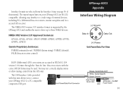
... Garmin Proprietary Sentences: PGRME (estimated error), PGRMM (datum string), PGRMZ (altitude), PSLIB (beacon receiver control) DGPS (Differential GPS) corrections are RS-232 compatible, allowing easy interface to a wide range of this unit allows you to connect your GPSmap 60CS are accepted in RTCM SC-104 version 2.0 format through the "Data In" line. Beacon receivers with this manual...
... Garmin Proprietary Sentences: PGRME (estimated error), PGRMM (datum string), PGRMZ (altitude), PSLIB (beacon receiver control) DGPS (Differential GPS) corrections are RS-232 compatible, allowing easy interface to a wide range of this unit allows you to connect your GPSmap 60CS are accepted in RTCM SC-104 version 2.0 format through the "Data In" line. Beacon receivers with this manual...


