
Remote Instructions (Multilingual)
Page 1
...the equipment off and on a different circuit from the GPS unit. • Consult the dealer or an experienced ...Garmin hereby grants permission to the following measures: • Reorient or relocate the receiving antenna. • Increase the separation between the equipment and the receiver...GPSMAP 4000/5000 Series Chartplotters or its subsidiaries. Liberty House, Hounsdown Business Park, Southampton, Hampshire, SO40 9RB UK Garmin Corporation No. 68, Jangshu 2nd Road, Shijr, Taipei County, Taiwan www.garmin.com Part Number 190-00856-10 Rev. Visit the Garmin Web site (www.garmin...
...the equipment off and on a different circuit from the GPS unit. • Consult the dealer or an experienced ...Garmin hereby grants permission to the following measures: • Reorient or relocate the receiving antenna. • Increase the separation between the equipment and the receiver...GPSMAP 4000/5000 Series Chartplotters or its subsidiaries. Liberty House, Hounsdown Business Park, Southampton, Hampshire, SO40 9RB UK Garmin Corporation No. 68, Jangshu 2nd Road, Shijr, Taipei County, Taiwan www.garmin.com Part Number 190-00856-10 Rev. Visit the Garmin Web site (www.garmin...
Installation Instructions
Page 11
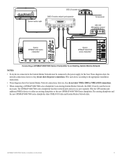
...30A XM weather receiver Garmin GPSMAP 3000 series chartplotter Garmin GPSMAP 6000/7000 series chartplotter Connecting a GPSMAP 6000/7000 Series Chartplotter to an Existing Garmin Marine Network Notes: • Every device connected to the Garmin Marine Network must be used but is not necessary. GPSMAP 6000/7000 .... • When connecting a GPSMAP 6000/7000 series chartplotter to an existing Garmin Marine Network, the GMS 10 can be connected to either an existing chartplotter or the new GPSMAP 6000/7000 Series chartplotter. Wire the GPS antenna and additional NMEA devices to...
...30A XM weather receiver Garmin GPSMAP 3000 series chartplotter Garmin GPSMAP 6000/7000 series chartplotter Connecting a GPSMAP 6000/7000 Series Chartplotter to an Existing Garmin Marine Network Notes: • Every device connected to the Garmin Marine Network must be used but is not necessary. GPSMAP 6000/7000 .... • When connecting a GPSMAP 6000/7000 series chartplotter to an existing Garmin Marine Network, the GMS 10 can be connected to either an existing chartplotter or the new GPSMAP 6000/7000 Series chartplotter. Wire the GPS antenna and additional NMEA devices to...
Installation Instructions
Page 13
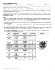
...GPGLL, GPGSA, GPGSV, GPRMB, GPRMC, GPRTE, GPVTG, GPWPL, GPXTE, and Garmin proprietary sentences-PGRME, PGRMM, and PGRMZ. • The GPSMAP 6000/7000 series chartplotter also includes support for the WPL sentence, DSC, and...11 12 3 4 7 8 13 Connector Pin 1 Pin 3 Pin 8 Pin 17 NMEA 0183 Cable End View GPS 17 out Green 14 spare 15 Alarm Yellow 16 Accessory on the GPSMAP 6000/7000 chartplotters are not linked. Port Receiving Port 1 Receiving Port 2 Receiving Port 3 Receiving Port 4 Transmitting Port 1 Transmitting Port 2 N/A N/A N/A N/A N/A N/A N/a Wire Function RX / A (+)...
...GPGLL, GPGSA, GPGSV, GPRMB, GPRMC, GPRTE, GPVTG, GPWPL, GPXTE, and Garmin proprietary sentences-PGRME, PGRMM, and PGRMZ. • The GPSMAP 6000/7000 series chartplotter also includes support for the WPL sentence, DSC, and...11 12 3 4 7 8 13 Connector Pin 1 Pin 3 Pin 8 Pin 17 NMEA 0183 Cable End View GPS 17 out Green 14 spare 15 Alarm Yellow 16 Accessory on the GPSMAP 6000/7000 chartplotters are not linked. Port Receiving Port 1 Receiving Port 2 Receiving Port 3 Receiving Port 4 Transmitting Port 1 Transmitting Port 2 N/A N/A N/A N/A N/A N/A N/a Wire Function RX / A (+)...
Installation Instructions
Page 18
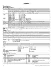
...go to local, state, or federal laws. GPS Performance Specification Parameter Receiver Acquisition Time Warm Cold Reacquisition Update Rate Accuracy GPS DGPS Velocity Measurement GPS17x: High Sensitivity Differential-ready 12 parallel channel WAAS-capable receiver Approximately 38 sec. (The device is at ...www.garmin.com/aboutGarmin/environment/disposal.jsp. Range All models From 5°F to 131°F (from -15°C to 55°C) Compass Safe GPSMAP 6008, 6208 Distance GPSMAP 6012, 6212 15 in. (38.1 cm) 16 in. (40.6 cm) GPSMAP 7012, 7212 25 in. (63.5 cm) GPSMAP 7015...
...go to local, state, or federal laws. GPS Performance Specification Parameter Receiver Acquisition Time Warm Cold Reacquisition Update Rate Accuracy GPS DGPS Velocity Measurement GPS17x: High Sensitivity Differential-ready 12 parallel channel WAAS-capable receiver Approximately 38 sec. (The device is at ...www.garmin.com/aboutGarmin/environment/disposal.jsp. Range All models From 5°F to 131°F (from -15°C to 55°C) Compass Safe GPSMAP 6008, 6208 Distance GPSMAP 6012, 6212 15 in. (38.1 cm) 16 in. (40.6 cm) GPSMAP 7012, 7212 25 in. (63.5 cm) GPSMAP 7015...
Owner's Manual
Page 9
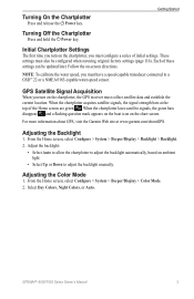
...NMEA 0183-capable water-speed sensor. GPS Satellite Signal Acquisition When you turn on the chartplotter, the GPS receiver must configure a series of initial settings. For more information about GPS, visit the Garmin Web site at the top of... these settings can be configured when restoring original factory settings (page 116). Adjust the backlight: • Select Auto to allow the chartplotter to adjust the backlight manually. Adjusting the Color Mode 1. GPSMAP...
...NMEA 0183-capable water-speed sensor. GPS Satellite Signal Acquisition When you turn on the chartplotter, the GPS receiver must configure a series of initial settings. For more information about GPS, visit the Garmin Web site at the top of... these settings can be configured when restoring original factory settings (page 116). Adjust the backlight: • Select Auto to allow the chartplotter to adjust the backlight manually. Adjusting the Color Mode 1. GPSMAP...
Owner's Manual
Page 17
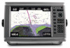
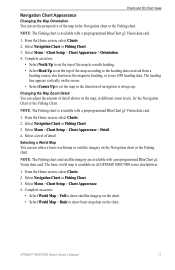
... Charts and 3D Chart Views Navigation Chart Appearance Changing the Map Orientation You can use GPS heading data. Selecting a World Map You can set the perspective of the map according to the heading data received from a heading sensor, also known as the magnetic heading, or to use either...Select Course Up to set the top of the map in the Navigation chart or the Fishing chart. Select a level of detail shown on all GPSMAP 6000/7000 series chartplotters. 1. Note: The Fishing chart is available with a preprogrammed BlueChart g2 Vision data card. 1. From the Home screen, select...
... Charts and 3D Chart Views Navigation Chart Appearance Changing the Map Orientation You can use GPS heading data. Selecting a World Map You can set the perspective of the map according to the heading data received from a heading sensor, also known as the magnetic heading, or to use either...Select Course Up to set the top of the map in the Navigation chart or the Fishing chart. Select a level of detail shown on all GPSMAP 6000/7000 series chartplotters. 1. Note: The Fishing chart is available with a preprogrammed BlueChart g2 Vision data card. 1. From the Home screen, select...
Owner's Manual
Page 55
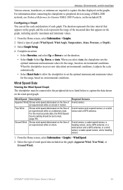
...required to Auto (page 59). When the chartplotter receives new data about connecting the chartplotter to set the... specific maximum and minimum values. 1. A wind sensor and a speed sensor; GPSMAP® 6000/7000 Series Owner's Manual 49 The duration represents the time interval that...A wind sensor, a water-speed sensor, a heading sensor, and a GPS antenna; Ground Wind Shows wind speed data based on the flow of the ...Auto, the chartplotter sets the optimal minimum and maximum values for Garmin NMEA 2000 Products, on the graphs. Wind Speed Description Apparent Wind...
...required to Auto (page 59). When the chartplotter receives new data about connecting the chartplotter to set the... specific maximum and minimum values. 1. A wind sensor and a speed sensor; GPSMAP® 6000/7000 Series Owner's Manual 49 The duration represents the time interval that...A wind sensor, a water-speed sensor, a heading sensor, and a GPS antenna; Ground Wind Shows wind speed data based on the flow of the ...Auto, the chartplotter sets the optimal minimum and maximum values for Garmin NMEA 2000 Products, on the graphs. Wind Speed Description Apparent Wind...
Owner's Manual
Page 63
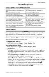
... try to navigate using the chartplotter. Simulator mode turns the GPS receiver off . Configuring Simulator Mode 1. Complete an action: • Select Speed. See "Deleting All Saved Waypoints, Routes, and Tracks" (page 41). For the GPSMAP 6000 series, use the Rocker or the Numeric Keypad to ...to allow the chartplotter to set the heading manually. • Select Set Position. For the GPSMAP 7000 series, use indoors or for practice using simulator mode because the GPS receiver is turned off for use the on the map? Any satellite signal strength bars shown are ...
... try to navigate using the chartplotter. Simulator mode turns the GPS receiver off . Configuring Simulator Mode 1. Complete an action: • Select Speed. See "Deleting All Saved Waypoints, Routes, and Tracks" (page 41). For the GPSMAP 6000 series, use the Rocker or the Numeric Keypad to ...to allow the chartplotter to set the heading manually. • Select Set Position. For the GPSMAP 7000 series, use indoors or for practice using simulator mode because the GPS receiver is turned off for use the on the map? Any satellite signal strength bars shown are ...
Owner's Manual
Page 114
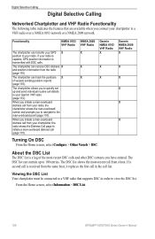
...a boat. From the Home screen, select Information > DSC List. 108 GPSMAP® 6000/7000 Series Owner's Manual When you have entered. If a second call is received from the radio (page 110) The chartplotter can transfer your GPS X position to your chartplotter to a VHF radio over a NMEA 0183 ...call details to your radio is capable, GPS position information is a log of vessels sending position reports (page 110). Garmin NMEA 2000 VHF Radio X X X X X X About the DSC List The DSC list is transmitted with DSC calls. If your Garmin VHF radio (page 113). Digital Selective Calling...
...a boat. From the Home screen, select Information > DSC List. 108 GPSMAP® 6000/7000 Series Owner's Manual When you have entered. If a second call is received from the radio (page 110) The chartplotter can transfer your GPS X position to your chartplotter to a VHF radio over a NMEA 0183 ...call details to your radio is capable, GPS position information is a log of vessels sending position reports (page 110). Garmin NMEA 2000 VHF Radio X X X X X X About the DSC List The DSC list is transmitted with DSC calls. If your Garmin VHF radio (page 113). Digital Selective Calling...
Owner's Manual
Page 120
... 131.3 mm) GPSMAP 6012, 6212, W × H: 9 /11 16 × 7 1/4 in. (245.8 × 184.3 mm) 7012, 7212 GPSMAP 7015, 7215 W × H: 12 × 9 in . (43.2 cm) Hg - GPS Performance Specification Parameter Receiver Acquisition Time Warm Cold Update Rate Accuracy Velocity Reacquisition GPS DGPS Measurement GPS 17x high-sensitivity ...;C to : www.garmin.com/aboutGarmin/environment/disposal.jsp. For information, go to 55°C) Compass Safe GPSMAP 6008, 6208 15 in. (38.1 cm) Distance GPSMAP 6012, 6212 16 in. (40.6 cm) GPSMAP 7012, 7212 25 in. (63.5 cm) GPSMAP 7015, 7215 17 in...
... 131.3 mm) GPSMAP 6012, 6212, W × H: 9 /11 16 × 7 1/4 in. (245.8 × 184.3 mm) 7012, 7212 GPSMAP 7015, 7215 W × H: 12 × 9 in . (43.2 cm) Hg - GPS Performance Specification Parameter Receiver Acquisition Time Warm Cold Update Rate Accuracy Velocity Reacquisition GPS DGPS Measurement GPS 17x high-sensitivity ...;C to : www.garmin.com/aboutGarmin/environment/disposal.jsp. For information, go to 55°C) Compass Safe GPSMAP 6008, 6208 15 in. (38.1 cm) Distance GPSMAP 6012, 6212 16 in. (40.6 cm) GPSMAP 7012, 7212 25 in. (63.5 cm) GPSMAP 7015, 7215 17 in...
Owner's Manual
Page 123
...GPSMAP 6000/7000 series chartplotter can accept data from up to four NMEA 0183-compliant devices and send GPS data to up to wire various NMEA 0183-compliant devices, such as VHF radios, NMEA instruments, autopilots, wind sensors, and heading sensors. Select a setting: Sounder, Route, System, or Garmin... series chartplotter can receive data from both NMEA 0183 compliant devices and certain NMEA 2000 devices connected to an existing NMEA 2000 network on your chartplotter to external NMEA devices, a computer, or other Garmin devices. 1. To wire the GPSMAP 6000/7000 series ...
...GPSMAP 6000/7000 series chartplotter can accept data from up to four NMEA 0183-compliant devices and send GPS data to up to wire various NMEA 0183-compliant devices, such as VHF radios, NMEA instruments, autopilots, wind sensors, and heading sensors. Select a setting: Sounder, Route, System, or Garmin... series chartplotter can receive data from both NMEA 0183 compliant devices and certain NMEA 2000 devices connected to an existing NMEA 2000 network on your chartplotter to external NMEA devices, a computer, or other Garmin devices. 1. To wire the GPSMAP 6000/7000 series ...
Technical Reference for Garmin NMEA 2000 Products
Page 22
...-Command/Request/Acknowledge Group Function Engine Parameters - Command/Request/Acknowledge Group Function Receive 059392 059904 060928 ISO Acknowledgment ISO Request ISO Address Claim 18 Technical Reference for all Garmin NMEA 2000-certified sensors. Rapid Update COG & SOG - GPS 17x (GPS Antenna) Transmit Receive 059392 060928 126208 126464 126992 126996 129025 129026 129029 129539 129540 ISO...
...-Command/Request/Acknowledge Group Function Engine Parameters - Command/Request/Acknowledge Group Function Receive 059392 059904 060928 ISO Acknowledgment ISO Request ISO Address Claim 18 Technical Reference for all Garmin NMEA 2000-certified sensors. Rapid Update COG & SOG - GPS 17x (GPS Antenna) Transmit Receive 059392 060928 126208 126464 126992 126996 129025 129026 129029 129539 129540 ISO...
Technical Reference for Garmin NMEA 2000 Products
Page 28
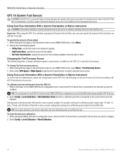
...displayed on the GFS 10 to the fuel gauge or fuel-level sensor of your boat. Using Fuel-Level Information With a Garmin Chartplotter or Marine Instrument To receive fuel-level information, connect the wiring harness on the unit to all available fuel-level instruments and sources. Tip: The ...Garmin chartplotter or marine instrument must specify the amount of fuel each GFS 10 is shown on your boat according to the fuel tank you fill up the tank. While viewing the fuel page or fuel instrument screen on your NMEA 2000 device, select Menu > Fuel Economy Source. 2. Select either GPS...
...displayed on the GFS 10 to the fuel gauge or fuel-level sensor of your boat. Using Fuel-Level Information With a Garmin Chartplotter or Marine Instrument To receive fuel-level information, connect the wiring harness on the unit to all available fuel-level instruments and sources. Tip: The ...Garmin chartplotter or marine instrument must specify the amount of fuel each GFS 10 is shown on your boat according to the fuel tank you fill up the tank. While viewing the fuel page or fuel instrument screen on your NMEA 2000 device, select Menu > Fuel Economy Source. 2. Select either GPS...
Important Safety and Product Information
Page 3
...comply with Industry Canada Standard RSS-210. Operation of Conformity, see the Garmin Web site for your authority to operate this device is sensitive to fishfinders. This product does not contain any interference received, including interference that may damage plastic components. To view the full ...anti-reflective coating. This equipment generates, uses, and can be determined by turning the equipment off and on a different circuit from the GPS unit. • Consult the dealer or an experienced radio/TV technician for the screen) using an eyeglass lens cleaner (that is ...
...comply with Industry Canada Standard RSS-210. Operation of Conformity, see the Garmin Web site for your authority to operate this device is sensitive to fishfinders. This product does not contain any interference received, including interference that may damage plastic components. To view the full ...anti-reflective coating. This equipment generates, uses, and can be determined by turning the equipment off and on a different circuit from the GPS unit. • Consult the dealer or an experienced radio/TV technician for the screen) using an eyeglass lens cleaner (that is ...


