Owner's Manual
Page 18
...map pointer ( ) to Off, Land Only, or On. High-resolution satellite imagery is connected to a compatible marine wind sensor. 12 GPSMAP 400/500 Series Owner's Manual Tides/Currents-turns tides and currents on or off . Roses-displays a compass ... card. If more information about on the chart with the map pointer, and press SELECT. Service Points-turns marine service points on different days. Select the item. Using Charts Accessing Additional Object Information Use the map pointer ...waypoints, and charts. You can view an in the area, select Review, and then select the item.
...map pointer ( ) to Off, Land Only, or On. High-resolution satellite imagery is connected to a compatible marine wind sensor. 12 GPSMAP 400/500 Series Owner's Manual Tides/Currents-turns tides and currents on or off . Roses-displays a compass ... card. If more information about on the chart with the map pointer, and press SELECT. Service Points-turns marine service points on different days. Select the item. Using Charts Accessing Additional Object Information Use the map pointer ...waypoints, and charts. You can view an in the area, select Review, and then select the item.
Owner's Manual
Page 26
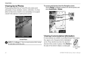
Using Charts Viewing Aerial Photos Preprogrammed BlueChart g2 Vision SD cards contain aerial photographs of the station to display a current graph. Select Review or the name of many landmarks, marinas, and harbors. To access aerial photos from the Navigation chart: Use the Rocker to highlight a camera icon... keys to zoom in your surroundings or to your BlueChart g2 Vision region, they appear on the full screen. Current-station icon 20 GPSMAP 400/500 Series Owner's Manual Use these photos to help orient yourself to acquaint yourself with the pointer, and select Aerial Photo or...
Using Charts Viewing Aerial Photos Preprogrammed BlueChart g2 Vision SD cards contain aerial photographs of the station to display a current graph. Select Review or the name of many landmarks, marinas, and harbors. To access aerial photos from the Navigation chart: Use the Rocker to highlight a camera icon... keys to zoom in your surroundings or to your BlueChart g2 Vision region, they appear on the full screen. Current-station icon 20 GPSMAP 400/500 Series Owner's Manual Use these photos to help orient yourself to acquaint yourself with the pointer, and select Aerial Photo or...

Owner's Manual
Page 30
...To view a list of all waypoints: From the Home screen, select Information > User Data > Waypoints. 24 GPSMAP 400/500 Series Owner's Manual Select Create Waypoint. Select Review. (The Review button is only shown when more than one waypoint is in the vicinity.) 3. Creating and Using Waypoints You ...can store up to 1,500 waypoints (3,000 waypoints for models GPSMAP 421/451/521/551/526/556, including "s" ...
...To view a list of all waypoints: From the Home screen, select Information > User Data > Waypoints. 24 GPSMAP 400/500 Series Owner's Manual Select Create Waypoint. Select Review. (The Review button is only shown when more than one waypoint is in the vicinity.) 3. Creating and Using Waypoints You ...can store up to 1,500 waypoints (3,000 waypoints for models GPSMAP 421/451/521/551/526/556, including "s" ...

Owner's Manual
Page 31
... create and store up to 20 routes (100 routes for models GPSMAP 421/451/521/551/526/556, including "s" models), with up to add additional turns. 5. If you want to delete. 3. Select Review > Delete (The Review button is only shown when more than one waypoint is complete. ...Press SELECT. Repeat until the route is in another location: 1. GPSMAP 400/500 Series Owner's Manual 25 From the Navigation chart, use the ...
... create and store up to 20 routes (100 routes for models GPSMAP 421/451/521/551/526/556, including "s" models), with up to add additional turns. 5. If you want to delete. 3. Select Review > Delete (The Review button is only shown when more than one waypoint is complete. ...Press SELECT. Repeat until the route is in another location: 1. GPSMAP 400/500 Series Owner's Manual 25 From the Navigation chart, use the ...
Owner's Manual
Page 45
...11. • If the Auto Guidance line is too close to the shore you want the auto-guidance line to be placed. GPSMAP 400/500 Series Owner's Manual 39 Shoreline Distance Auto Guidance Setting The Shoreline Distance setting indicates how close to known obstacles, from ... from the Home screen, select Configure > Preferences > Navigation > Auto Guidance > Shoreline Distance > Near. 8. Dock your boat or drop anchor. 2. Review the placement of the Auto Guidance line. Determine whether the line safely avoids known obstacles, and whether the turns enable efficient travel . 9. Complete an action...
...11. • If the Auto Guidance line is too close to the shore you want the auto-guidance line to be placed. GPSMAP 400/500 Series Owner's Manual 39 Shoreline Distance Auto Guidance Setting The Shoreline Distance setting indicates how close to known obstacles, from ... from the Home screen, select Configure > Preferences > Navigation > Auto Guidance > Shoreline Distance > Near. 8. Dock your boat or drop anchor. 2. Review the placement of the Auto Guidance line. Determine whether the line safely avoids known obstacles, and whether the turns enable efficient travel . 9. Complete an action...
Owner's Manual
Page 46
...computer, or other Garmin devices. • Garmin Data Transfer-supports the input or output of Garmin-proprietary data for communicating with Garmin software. • Garmin Remote Sonar Transfer (GPSMAP 40 420/450/520/550/525/555)-supports the input or output of Garmin-proprietary sonar data ...output sentences for most AIS receivers. Configuring Communications Settings To change the communications settings from the Home screen, select Configure > Preferences > Navigation > Auto Guidance > Shoreline Distance > Nearest. 10.If you are familiar with Garmin software. • NMEA Standard...
...computer, or other Garmin devices. • Garmin Data Transfer-supports the input or output of Garmin-proprietary data for communicating with Garmin software. • Garmin Remote Sonar Transfer (GPSMAP 40 420/450/520/550/525/555)-supports the input or output of Garmin-proprietary sonar data ...output sentences for most AIS receivers. Configuring Communications Settings To change the communications settings from the Home screen, select Configure > Preferences > Navigation > Auto Guidance > Shoreline Distance > Nearest. 10.If you are familiar with Garmin software. • NMEA Standard...
Owner's Manual
Page 57
... information on making an individual routine call . 2. If position information was sent. GPSMAP 400/500 Series Owner's Manual 51 Select DSC to change the line color. The...off : 1. Digital Selective Calling Receiving Distress Calls If your VHF radio receives a DSC distress call . When you when your Garmin chartplotter and VHF radio are using a Garmin NMEA 2000compatible VHF radio. •.... Viewing the DSC List The DSC list is received from a boat. The symbol designates a distress call in distress (page 53). Select Review to delete the call is a log of the...
... information on making an individual routine call . 2. If position information was sent. GPSMAP 400/500 Series Owner's Manual 51 Select DSC to change the line color. The...off : 1. Digital Selective Calling Receiving Distress Calls If your VHF radio receives a DSC distress call . When you when your Garmin chartplotter and VHF radio are using a Garmin NMEA 2000compatible VHF radio. •.... Viewing the DSC List The DSC list is received from a boat. The symbol designates a distress call in distress (page 53). Select Review to delete the call is a log of the...
Owner's Manual
Page 60
Select Review > Call with Radio. 3. Select Send to send the information about the call to the radio. 5. Select AIS Vessel > Call with Radio. 4. Select the station to ... routine call from the list. 3. Select Send to send the information about the call to select an AIS target . 2. On your Garmin VHF radio, select Call. Calling an AIS Target When you connect your Garmin chartplotter to a Garmin VHF NMEA 2000-compatible radio, you can use the Rocker to the radio. 4. On your...
Select Review > Call with Radio. 3. Select Send to send the information about the call to the radio. 5. Select AIS Vessel > Call with Radio. 4. Select the station to ... routine call from the list. 3. Select Send to send the information about the call to select an AIS target . 2. On your Garmin VHF radio, select Call. Calling an AIS Target When you connect your Garmin chartplotter to a Garmin VHF NMEA 2000-compatible radio, you can use the Rocker to the radio. 4. On your...