'Plus' Features Addendum
Page 2
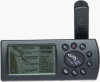
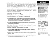
... city/town locations. A window will operate up to 36 hours. Overview Based on the very popular GPS III, your new GPS III Plus is a new GARMIN product that allows you to download additional maps from the GARMIN MapSource CD to your GPS III Plus. MapSource Info — MapSource (available separately) is packed with additional features and a few new operating characteristics. With the unit...
... city/town locations. A window will operate up to 36 hours. Overview Based on the very popular GPS III, your new GPS III Plus is a new GARMIN product that allows you to download additional maps from the GARMIN MapSource CD to your GPS III Plus. MapSource Info — MapSource (available separately) is packed with additional features and a few new operating characteristics. With the unit...
'Plus' Features Addendum
Page 3
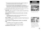
...145;n Find feature allows you don’t wish to save an exit location as fuels, parking, convenience stores, etc. 5. To select a city from MapSource. To save the city location as a waypoint, press MENU and select the “Save as follows: Large cities are available as well—including the... disable the selected exit category entirely or select the maximum scale at the bottom of the city name, the GPS III Plus will automatically be removed from “Wpts” in the GPS III manual) file tab. 4. To select/deselect a map, highlight the field adjacent to display the Map Page ...
...145;n Find feature allows you don’t wish to save an exit location as fuels, parking, convenience stores, etc. 5. To select a city from MapSource. To save the city location as a waypoint, press MENU and select the “Save as follows: Large cities are available as well—including the... disable the selected exit category entirely or select the maximum scale at the bottom of the city name, the GPS III Plus will automatically be removed from “Wpts” in the GPS III manual) file tab. 4. To select/deselect a map, highlight the field adjacent to display the Map Page ...
Owner's Manual
Page 2
... notify any unauthorized commercial distribution of GARMIN Corporation. Visit the GARMIN web site (www.garmin.com) for personal use and operation of such changes. B Printed in this manual is strictly prohibited. GARMIN®, Autolocate®, TracBack®, and Phasetrac 12® are registered trademarks and MapSource™ is a trademark of GARMIN Corporation and may be reproduced, copied...
... notify any unauthorized commercial distribution of GARMIN Corporation. Visit the GARMIN web site (www.garmin.com) for personal use and operation of such changes. B Printed in this manual is strictly prohibited. GARMIN®, Autolocate®, TracBack®, and Phasetrac 12® are registered trademarks and MapSource™ is a trademark of GARMIN Corporation and may be reproduced, copied...
Owner's Manual
Page 47
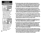
... 2. To Enable/Disable All maps, press MENU from ) and press ENTER. 3. allows you to scroll through the list of maps downloaded from the optional MapSource software package. Highlight 'Measure Dist' and press ENTER. shows the number of downloaded maps. 3. An on-screen pointer will be displayed on the Map Page...map. Each downloaded map is described by name, and may be deselected if you want to measure to that have been downloaded from the optional MapSource software package and the amount of memory used (in map with up to 1.44 MB of the desired map. Press ENTER to the immediate...
... 2. To Enable/Disable All maps, press MENU from ) and press ENTER. 3. allows you to scroll through the list of maps downloaded from the optional MapSource software package. Highlight 'Measure Dist' and press ENTER. shows the number of downloaded maps. 3. An on-screen pointer will be displayed on the Map Page...map. Each downloaded map is described by name, and may be deselected if you want to measure to that have been downloaded from the optional MapSource software package and the amount of memory used (in map with up to 1.44 MB of the desired map. Press ENTER to the immediate...
Owner's Manual
Page 49
... for details. To view the map area around an item on the selected item. To save the new waypoint. allows you do not have optional MapSource data loaded, only airports will be shown. Press MENU, then select 'Show Map' (from the Info Page Options) and press ENTER. Items with names longer...
... for details. To view the map area around an item on the selected item. To save the new waypoint. allows you do not have optional MapSource data loaded, only airports will be shown. Press MENU, then select 'Show Map' (from the Info Page Options) and press ENTER. Items with names longer...

Owner's Manual
Page 51
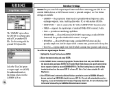
... the various settings and easier for which you have approximate populations under each tab: Map Detail, Orientation, AutoZoom, Accuracy Circle Source Built-in Base Map, MapSource Files Line Track Log, Active Route Lines, Local Roads, Street Labels Pnts All Waypoints and Text, Active Route Wpts, Exits City Large/Medium/Small Cities...
... the various settings and easier for which you have approximate populations under each tab: Map Detail, Orientation, AutoZoom, Accuracy Circle Source Built-in Base Map, MapSource Files Line Track Log, Active Route Lines, Local Roads, Street Labels Pnts All Waypoints and Text, Active Route Wpts, Exits City Large/Medium/Small Cities...
Owner's Manual
Page 52
...: select the appropriate tab (per the chart on screen, or select 'Off' to enable or disable automatic zoom. Press ENTER to highlight 'Basemap' or 'MapSource' and press ENTER. To change map orientation, select the 'Map' tab (if not already selected). Select 'Course Up' to fix the top of the...disable text, and press ENTER. 8. Select the text size for the desired feature and press ENTER. To enable/disable the built-in base map or MapSource files, select the 'Source' tab. Select the maximum scale at 800 ft. Scroll down to accept the settings. For all waypoints, active route waypoints,...
...: select the appropriate tab (per the chart on screen, or select 'Off' to enable or disable automatic zoom. Press ENTER to highlight 'Basemap' or 'MapSource' and press ENTER. To change map orientation, select the 'Map' tab (if not already selected). Select 'Course Up' to fix the top of the...disable text, and press ENTER. 8. Select the text size for the desired feature and press ENTER. To enable/disable the built-in base map or MapSource files, select the 'Source' tab. Select the maximum scale at 800 ft. Scroll down to accept the settings. For all waypoints, active route waypoints,...
Owner's Manual
Page 94
... beacon receiver, a personal computer, etc. GBR 21/23) directly from a PC. For additional details on this setting with another GPS III+. allows Differential GPS (DGPS) input using the III+ with a PC or another GPS III+. • GRMN DGPS - The unit will automatically scan for your GARMIN differential beacon receiver. the proprietary format used to upload/download MapSource data, exchange...
... beacon receiver, a personal computer, etc. GBR 21/23) directly from a PC. For additional details on this setting with another GPS III+. allows Differential GPS (DGPS) input using the III+ with a PC or another GPS III+. • GRMN DGPS - The unit will automatically scan for your GARMIN differential beacon receiver. the proprietary format used to upload/download MapSource data, exchange...
Owner's Manual
Page 101
... new entries. Waypoint Already Exists-The name you are no additional routes can be taken to an authorized GARMIN dealer for repair. If the message persists, the GPS III+ is unusable and should be added from another track log already stored in its internal memory. If this...lost . Steep Turn Ahead-This message appears approximately one minute prior to another GPS III+ or uploaded from the route. Enter a different name for Faster Data Transfer-While using the PC Software Kit or the MapSource program, simulator mode is removed from waypoint memory and from a PC. ...
... new entries. Waypoint Already Exists-The name you are no additional routes can be taken to an authorized GARMIN dealer for repair. If the message persists, the GPS III+ is unusable and should be added from another track log already stored in its internal memory. If this...lost . Steep Turn Ahead-This message appears approximately one minute prior to another GPS III+ or uploaded from the route. Enter a different name for Faster Data Transfer-While using the PC Software Kit or the MapSource program, simulator mode is removed from waypoint memory and from a PC. ...
Owner's Manual
Page 109
Options 56-57 GPS Overview 4 H Heading Selection 76 Highlight 2 Highway Display 12,24,43 Highway Page 12,24,43 Highway... Orientation 10,19,39-40 Map Page 10,19,33-34 Map Page Options 37-40 Map Scale 10,19,33 Map Setup 39-40 MapSource Data . . . . . 37,39,42,84,91 Mark Position Page 14,22,45 Marking a Position . . . . . .14,22,45-46 Maximum... . . . 38 Menu Key 2 Messages 86-87 MGRS Coordinates 82 APPENDIX I Index MOB Function 53,55 Mounting 82 N Navigation Basics 91-92 Navigation Units 76 Nearest Cities 15,38-41,51-52 Nearest Exits 15,38-41,51-52 Nearest Geo Points . . . 15,38...
Options 56-57 GPS Overview 4 H Heading Selection 76 Highlight 2 Highway Display 12,24,43 Highway Page 12,24,43 Highway... Orientation 10,19,39-40 Map Page 10,19,33-34 Map Page Options 37-40 Map Scale 10,19,33 Map Setup 39-40 MapSource Data . . . . . 37,39,42,84,91 Mark Position Page 14,22,45 Marking a Position . . . . . .14,22,45-46 Maximum... . . . 38 Menu Key 2 Messages 86-87 MGRS Coordinates 82 APPENDIX I Index MOB Function 53,55 Mounting 82 N Navigation Basics 91-92 Navigation Units 76 Nearest Cities 15,38-41,51-52 Nearest Exits 15,38-41,51-52 Nearest Geo Points . . . 15,38...


