Owner's Manual
Page 2
.../2/2642.9199 Fax: 886/2.2642.9099 Web Site Address: www.garmin.com © 1999-2001 GARMIN Corporation. Information in the content without obligation to notify any person or organization of GARMIN Corporation. GARMIN Corporation reserves the right to make changes in this manual is ...174; are registered trademarks and MapSource™ is a trademark of GARMIN Corporation and may be viewed for personal use and operation of GARMIN Corporation. B Printed in any storage medium, for current updates and supplemental information concerning the use , provided that such electronic or...
.../2/2642.9199 Fax: 886/2.2642.9099 Web Site Address: www.garmin.com © 1999-2001 GARMIN Corporation. Information in the content without obligation to notify any person or organization of GARMIN Corporation. GARMIN Corporation reserves the right to make changes in this manual is ...174; are registered trademarks and MapSource™ is a trademark of GARMIN Corporation and may be viewed for personal use and operation of GARMIN Corporation. B Printed in any storage medium, for current updates and supplemental information concerning the use , provided that such electronic or...
Owner's Manual
Page 7
... purchase using our on-line system. Why should you register your GARMIN GPS unit: • Notification of Product Updates • Notification of your GPS III+ handy and connect to our web site (www.garmin.com). INTRODUCTION Registration Customer Service Product Registration Help us better support you by our new product registration system are now being automated...
... purchase using our on-line system. Why should you register your GARMIN GPS unit: • Notification of Product Updates • Notification of your GPS III+ handy and connect to our web site (www.garmin.com). INTRODUCTION Registration Customer Service Product Registration Help us better support you by our new product registration system are now being automated...
Owner's Manual
Page 15
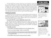
... view of initialization options. 2. A message will be displayed while the unit conducts a self test. Use the rocker keypad to update your GPS III+ in view. A three-dimensional fix means the unit knows its latitude, longitude, and altitude, while a two-dimensional fix means...the position and begin searching for '2D Navigation' or '3D Navigation' to identify your unit: 1. GETTING STARTED Initialization Check the Satellite Status Page for satellites. Once the GPS III+ has calculated a position fix, you use your position. Although a GPS receiver needs four satellites to provide a...
... view of initialization options. 2. A message will be displayed while the unit conducts a self test. Use the rocker keypad to update your GPS III+ in view. A three-dimensional fix means the unit knows its latitude, longitude, and altitude, while a two-dimensional fix means...the position and begin searching for '2D Navigation' or '3D Navigation' to identify your unit: 1. GETTING STARTED Initialization Check the Satellite Status Page for satellites. Once the GPS III+ has calculated a position fix, you use your position. Although a GPS receiver needs four satellites to provide a...
Owner's Manual
Page 35
...page. A solid signal bar means the satellite is collecting data. • Solid signal strength bars- Once a fix has been calculated, the GPS III+ will appear for navigation (solid bar status). the inner circle 45º above the horizon; The progress of what satellites are visible to save the settings. 25 ...'s last known position. The outer circle represents the horizon (north up); As the receiver locks onto satellites, a signal strength bar will then update your position, track, and speed by selecting and using the best satellites in three stages: • No signal strength bars-
...page. A solid signal bar means the satellite is collecting data. • Solid signal strength bars- Once a fix has been calculated, the GPS III+ will appear for navigation (solid bar status). the inner circle 45º above the horizon; The progress of what satellites are visible to save the settings. 25 ...'s last known position. The outer circle represents the horizon (north up); As the receiver locks onto satellites, a signal strength bar will then update your position, track, and speed by selecting and using the best satellites in three stages: • No signal strength bars-
Owner's Manual
Page 48
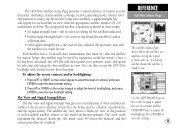
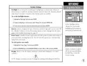
... info page for the desired nearest list. 4. For cities, the information includes state, country, size or reference, and position. The nearest locations pages are continuously updated as described on the screen. Scroll through the selected nearest list (as outlined on pages 50-51. 4. REFERENCE Map Page Options The 'Nearest to Pntr...
... info page for the desired nearest list. 4. For cities, the information includes state, country, size or reference, and position. The nearest locations pages are continuously updated as described on the screen. Scroll through the selected nearest list (as outlined on pages 50-51. 4. REFERENCE Map Page Options The 'Nearest to Pntr...
Owner's Manual
Page 62
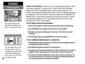
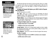
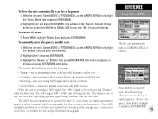
... appear on the map display. 52 The Waypoint Edit Page also features an options page that allows you to average position samples over time to update the waypoint's position with the Waypoint Edit Page displayed). Average Position- The following options are provided to cancel). While viewing the map display, you to...
... appear on the map display. 52 The Waypoint Edit Page also features an options page that allows you to average position samples over time to update the waypoint's position with the Waypoint Edit Page displayed). Average Position- The following options are provided to cancel). While viewing the map display, you to...
Owner's Manual
Page 63
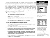
... Edit Page. For cities, the information includes state, country, size or reference, and position. Another waypoint feature of the GPS III+ is displayed on pages 69-71. 5. The nearest locations pages are continuously updated as described above) and highlight the desired location (Waypoint, City or Exit). 2. To view additional information for Waypoints, Cities...
... Edit Page. For cities, the information includes state, country, size or reference, and position. Another waypoint feature of the GPS III+ is displayed on pages 69-71. 5. The nearest locations pages are continuously updated as described above) and highlight the desired location (Waypoint, City or Exit). 2. To view additional information for Waypoints, Cities...

Owner's Manual
Page 76
...along the route denoted by name) of the active route, along the current route will show each route waypoint. See page 95 for navigation guidance. As you to each waypoint, fuel requirements or sunrise/sunset times at each waypoint (by an arrow on the right side ...distance to waypoint, time to remove all routes from memory. allows you navigate the route, the information on the left -hand side of current conditions. To delete all routes from memory: 1. A confirmation page will automatically update to indicate the destination waypoint and any waypoint in the main sequence (...
...along the route denoted by name) of the active route, along the current route will show each route waypoint. See page 95 for navigation guidance. As you to each waypoint, fuel requirements or sunrise/sunset times at each waypoint (by an arrow on the right side ...distance to waypoint, time to remove all routes from memory. allows you navigate the route, the information on the left -hand side of current conditions. To delete all routes from memory: 1. A confirmation page will automatically update to indicate the destination waypoint and any waypoint in the main sequence (...
Owner's Manual
Page 87
...or 'OFF') and press ENTER. Highlight the 'Backlight' field and press ENTER. 2. Battery is suitable for most applications and offers position updates which adapt to power your needs while extending battery life. Display allows you keep backlighting on the Satellite Status Page (see page 27). ... prevent the backlighting from the battery gauge on continuously, select 'Always On' and press ENTER, OR 3. To set the backlight timeout: 1. The GPS III+ will operate up to 4 minutes (since last key press) are available. To set a timeout duration, select the desired time period and press ...
...or 'OFF') and press ENTER. Highlight the 'Backlight' field and press ENTER. 2. Battery is suitable for most applications and offers position updates which adapt to power your needs while extending battery life. Display allows you keep backlighting on the Satellite Status Page (see page 27). ... prevent the backlighting from the battery gauge on continuously, select 'Always On' and press ENTER, OR 3. To set the backlight timeout: 1. The GPS III+ will operate up to 4 minutes (since last key press) are available. To set a timeout duration, select the desired time period and press ...

Owner's Manual
Page 88
... grid position formats described on page 82). 'User Mag Var' allows you must periodically update the magnetic variation as a magnetic compass. If 'User Mag Var' is selected, you to update this setting, the GPS III+ will not automatically calculate and update the magnetic variation at your area. 'Auto Mag Var' is the preferred setting in...
... grid position formats described on page 82). 'User Mag Var' allows you must periodically update the magnetic variation as a magnetic compass. If 'User Mag Var' is selected, you to update this setting, the GPS III+ will not automatically calculate and update the magnetic variation at your area. 'Auto Mag Var' is the preferred setting in...
Owner's Manual
Page 95
...scan: 1. With the unit set to 'Garmin DGPS' or 'RTCM/NMEA', use the ARROW KEYPAD to view the last 5 valid frequencies. Highlight 'User' and press ENTER/MARK. 3. The "Status" field will change as the unit scans from 284 kHz to find the most updated list of the following: • Tuning... allows you to highlight the 'Tuning Mode' field and press ENTER/MARK. 2. Highlight 'Scan' and press ENTER/MARK. REFERENCE Setup Menu: DGPS The III+ can automatically tune the GARMIN GBR 21 or GBR 23. With the unit set to 'Garmin DGPS' or 'RTCM/NMEA', use a frequency from the DGPS site.
...scan: 1. With the unit set to 'Garmin DGPS' or 'RTCM/NMEA', use the ARROW KEYPAD to view the last 5 valid frequencies. Highlight 'User' and press ENTER/MARK. 3. The "Status" field will change as the unit scans from 284 kHz to find the most updated list of the following: • Tuning... allows you to highlight the 'Tuning Mode' field and press ENTER/MARK. 2. Highlight 'Scan' and press ENTER/MARK. REFERENCE Setup Menu: DGPS The III+ can automatically tune the GARMIN GBR 21 or GBR 23. With the unit set to 'Garmin DGPS' or 'RTCM/NMEA', use a frequency from the DGPS site.
Owner's Manual
Page 97
...start) Approx. 45 seconds (EZinit/cold start) Approx. 5 minutes (AutoLocate™) Update Rate: 1/second, continuous Position Accuracy: 3-5 meters (10-16 ft) with your unit, please contact your GARMIN dealer or GARMIN Customer Service. Should you ever encounter a problem with DGPS corrections, 95% typical* ... batteries Temperature Range: 5 to 158ºF (-15º to come into contact with the case. To protect your warranty. The GPS III+ is constructed of high-quality materials and should not require user APPENDIX B maintenance. Never attempt any repairs yourself, as this may cause...
...start) Approx. 45 seconds (EZinit/cold start) Approx. 5 minutes (AutoLocate™) Update Rate: 1/second, continuous Position Accuracy: 3-5 meters (10-16 ft) with your unit, please contact your GARMIN dealer or GARMIN Customer Service. Should you ever encounter a problem with DGPS corrections, 95% typical* ... batteries Temperature Range: 5 to 158ºF (-15º to come into contact with the case. To protect your warranty. The GPS III+ is constructed of high-quality materials and should not require user APPENDIX B maintenance. Never attempt any repairs yourself, as this may cause...


