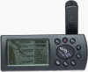
'Plus' Features Addendum
Page 2
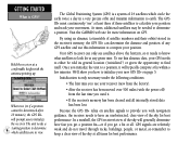
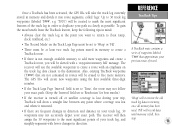
...re all described in two ways: In normal operation, your new GPS III Plus is packed with additional features and a few new operating characteristics. However, if you’d like to receive a completely new GPS III Plus owner’s manual free of the ROCKER KEYPAD to 18 hours.... Mail To: GARMIN International, Inc., ATTN: Order Desk, 1200 East 151st Street, Olathe, KS 66062 Please send me a FREE GPS III Plus Owner’s Manual Name GPS III Plus Serial #:________ Address Phone Date of Purchase Battery Life GPS III Plus battery life is improved in this handy “Plus” Features...
...re all described in two ways: In normal operation, your new GPS III Plus is packed with additional features and a few new operating characteristics. However, if you’d like to receive a completely new GPS III Plus owner’s manual free of the ROCKER KEYPAD to 18 hours.... Mail To: GARMIN International, Inc., ATTN: Order Desk, 1200 East 151st Street, Olathe, KS 66062 Please send me a FREE GPS III Plus Owner’s Manual Name GPS III Plus Serial #:________ Address Phone Date of Purchase Battery Life GPS III Plus battery life is improved in this handy “Plus” Features...
Owner's Manual
Page 5
...other equipment, which can radiate radio frequency energy and, if not installed and used in a particular installation. The GPS III+ does not contain any interference received, including interference that interference will not occur in accordance with Part 15 of this device is subject to operate ...other qualified service technician for Class B digital devices. Furthermore, there is encouraged to try and correct the interference by an authorized GARMIN service center. If this device must accept any user-serviceable parts. This equipment generates, uses, and can be made by ...
...other equipment, which can radiate radio frequency energy and, if not installed and used in a particular installation. The GPS III+ does not contain any interference received, including interference that interference will not occur in accordance with Part 15 of this device is subject to operate ...other qualified service technician for Class B digital devices. Furthermore, there is encouraged to try and correct the interference by an authorized GARMIN service center. If this device must accept any user-serviceable parts. This equipment generates, uses, and can be made by ...
Owner's Manual
Page 10
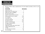
TO DO THIS: SEE PAGE(S): Turn the unit on or off 5 Initialize the GPS receiver (first time use 5 Adjust screen contrast or backlighting 25 Enter data and select options 2 Learn how to help you quickly find some of the more ... will use a route 60 Learn about the map page 10,33 Pan using the map arrow 20,34 Zoom in or out on your new GPS III+. INTREOFDEURCETNIOCEN P"rHooxwimTioty" WInadyepxoints This list is provided to operate the unit's function keys 2 Mark your present location as a waypoint 14,22 Goto a destination 15,55...
TO DO THIS: SEE PAGE(S): Turn the unit on or off 5 Initialize the GPS receiver (first time use 5 Adjust screen contrast or backlighting 25 Enter data and select options 2 Learn how to help you quickly find some of the more ... will use a route 60 Learn about the map page 10,33 Pan using the map arrow 20,34 Zoom in or out on your new GPS III+. INTREOFDEURCETNIOCEN P"rHooxwimTioty" WInadyepxoints This list is provided to operate the unit's function keys 2 Mark your present location as a waypoint 14,22 Goto a destination 15,55...
Owner's Manual
Page 14
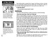
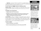
...GPS III+ must continuously "see satellites above the horizon, so it needs to know what satellites to look for more information on page 5. Visit the GARMIN web site for at any GPS satellite and use this almanac data, your position. We'll show you how to initialize the receiver. In a nutshell, the GPS receiver... day in the receiver's memory, the GPS III+ can only see " at a comfortable height with navigation guidance, the receiver needs to a position, it . • If the receiver's memory has been cleared and all . To use your movement. Your GPS receiver can determine the ...
...GPS III+ must continuously "see satellites above the horizon, so it needs to know what satellites to look for more information on page 5. Visit the GARMIN web site for at any GPS satellite and use this almanac data, your position. We'll show you how to initialize the receiver. In a nutshell, the GPS receiver... day in the receiver's memory, the GPS III+ can only see " at a comfortable height with navigation guidance, the receiver needs to a position, it . • If the receiver's memory has been cleared and all . To use your movement. Your GPS receiver can determine the ...
Owner's Manual
Page 15
... while the unit conducts a self test. To initialize the GPS III+, designate your approximate location directly on , press and hold the receiver at a comfortable height with only three satellites. Once the GPS III+ has calculated a position fix, you'll usually have anywhere...GPS III+ To initialize the GPS III+, take the receiver outside and find an open area where the antenna has a clear view of a vehicle (Appendix A) or on a bike. (Likewise, when you to identify your position. Use the rocker keypad to select the position and begin searching for '2D Navigation' or '3D Navigation...
... while the unit conducts a self test. To initialize the GPS III+, designate your approximate location directly on , press and hold the receiver at a comfortable height with only three satellites. Once the GPS III+ has calculated a position fix, you'll usually have anywhere...GPS III+ To initialize the GPS III+, take the receiver outside and find an open area where the antenna has a clear view of a vehicle (Appendix A) or on a bike. (Likewise, when you to identify your position. Use the rocker keypad to select the position and begin searching for '2D Navigation' or '3D Navigation...
Owner's Manual
Page 16
.... see page 29). Your receiver is heavy tree cover, the receiver may not be necessary to mount an external antenna on your local GARMIN dealer or GARMIN Sales and inquire about the GA 26C low-profile remote antenna, part number 010-10052-04.) • Have you 're using the GPS III+ on the map, or select...
.... see page 29). Your receiver is heavy tree cover, the receiver may not be necessary to mount an external antenna on your local GARMIN dealer or GARMIN Sales and inquire about the GA 26C low-profile remote antenna, part number 010-10052-04.) • Have you 're using the GPS III+ on the map, or select...
Owner's Manual
Page 18
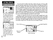
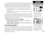
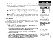
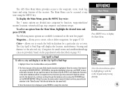
...view while your unit is getting a position fix. The signal strength bars depict the relative strength of the signal from 01 through 32. Receiver Status Signal Strength Bar If satellite reception is lost, or an insufficient number of your current position fix (acquiring, 2D, 3D, etc.),... any given time, and it's a page that helps you understand what satellites are visible to the receiver, whether or not they're being received. Let's start with a 'Poor Coverage' receiver status and message. 8 Battery Level Indicator Satellite Status Page Sky View The Satellite Status Page shows you...
...view while your unit is getting a position fix. The signal strength bars depict the relative strength of the signal from 01 through 32. Receiver Status Signal Strength Bar If satellite reception is lost, or an insufficient number of your current position fix (acquiring, 2D, 3D, etc.),... any given time, and it's a page that helps you understand what satellites are visible to the receiver, whether or not they're being received. Let's start with a 'Poor Coverage' receiver status and message. 8 Battery Level Indicator Satellite Status Page Sky View The Satellite Status Page shows you...
Owner's Manual
Page 27
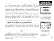
...on , press and hold the red power key. Once testing is complete, the Welcome Page is first turned on . The GPS III+ is a powerful navigation system providing detailed mapping information in the tour may not match your configuration. The Welcome Page will automatically return to normal mode... press ENTER. After a brief self-test, it on . If the GPS III+ is replaced by turning it is currently off , it will be consulted for actual navigation. The simulator tour assumes that the receiver has been properly initialized as outlined in the Getting Started section of your new...
...on , press and hold the red power key. Once testing is complete, the Welcome Page is first turned on . The GPS III+ is a powerful navigation system providing detailed mapping information in the tour may not match your configuration. The Welcome Page will automatically return to normal mode... press ENTER. After a brief self-test, it on . If the GPS III+ is replaced by turning it is currently off , it will be consulted for actual navigation. The simulator tour assumes that the receiver has been properly initialized as outlined in the Getting Started section of your new...
Owner's Manual
Page 28
... navigation. Press MENU to see that automatic sequence of the main pages in reverse order. Press ENTER again to use this mode the GPS III+ is ready to acknowledge the simulator warning message. Press PAGE to move on the Satellite Status Page. At that point the receiver ... The simulator imitates satellite reception and shows that information on the GPS III+. If you cycle through each of steps, but as you 've already initialized the receiver, as a starting location. Let's look at the sequence of the GPS III+. Press QUIT to sequence through the main pages: 1. The ...
... navigation. Press MENU to see that automatic sequence of the main pages in reverse order. Press ENTER again to use this mode the GPS III+ is ready to acknowledge the simulator warning message. Press PAGE to move on the Satellite Status Page. At that point the receiver ... The simulator imitates satellite reception and shows that information on the GPS III+. If you cycle through each of steps, but as you 've already initialized the receiver, as a starting location. Let's look at the sequence of the GPS III+. Press QUIT to sequence through the main pages: 1. The ...
Owner's Manual
Page 35
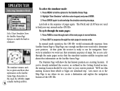
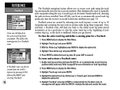
...receiver is ready for navigation (solid bar status). To adjust the screen contrast and/or backlighting: 1. the inner circle 45º above the horizon; REFERENCE Satellite Status Page The Satellite Status Page shows where the satellites are being used for use . As the receiver...and press ENTER to save the new contrast setting. 2. The GPS III+'s Satellite Status Page provides a visual reference of satellite acquisition is from this page. The progress of various receiver functions, including current satellite coverage, receiver operating mode, battery level and position accuracy.
...receiver is ready for navigation (solid bar status). To adjust the screen contrast and/or backlighting: 1. the inner circle 45º above the horizon; REFERENCE Satellite Status Page The Satellite Status Page shows where the satellites are being used for use . As the receiver...and press ENTER to save the new contrast setting. 2. The GPS III+'s Satellite Status Page provides a visual reference of satellite acquisition is from this page. The progress of various receiver functions, including current satellite coverage, receiver operating mode, battery level and position accuracy.
Owner's Manual
Page 36
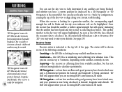
... the sky view to 5 minutes, depending on the satellites currently in 2D mode. 3D Navigation- You can use the sky view to determine altitude. See page 29.) Receiver Status Receiver status is initializing and collecting new almanac data. the GPS III+ is indicated at least four satellites with good geometry have been locked onto, and...
... the sky view to 5 minutes, depending on the satellites currently in 2D mode. 3D Navigation- You can use the sky view to determine altitude. See page 29.) Receiver Status Receiver status is initializing and collecting new almanac data. the GPS III+ is indicated at least four satellites with good geometry have been locked onto, and...

Owner's Manual
Page 37
... if a position fix cannot be deter- the receiver is not running off batteries or external power. The prompt may also appear during normal use your GPS III+. NiCad and lithium batteries will maintain the unit's memory when the receiver is unusable, possibly due to reset, and reinitialize... the receiver if necessary. After acknowledging the message, select 'Use Map' or '...
... if a position fix cannot be deter- the receiver is not running off batteries or external power. The prompt may also appear during normal use your GPS III+. NiCad and lithium batteries will maintain the unit's memory when the receiver is unusable, possibly due to reset, and reinitialize... the receiver if necessary. After acknowledging the message, select 'Use Map' or '...
Owner's Manual
Page 38
... and/or select special features which specifically relate to current direction of Precision (DOP) figures. To change the sky view orientation or initialize the receiver. 'AutoLocate' forces the receiver to search for all satellites (twelve at a time) until enough satellites are menu driven. To activate (deactivate) simulator mode: 1. Highlight 'Track Up'...DOP and other ) on a scale from 'North Up' orientation to align to that page. Track Up- DOP measures satellite geometry quality (i.e., number of the GPS III+ are found to activate the GPS III+'s built-in feet or meters.
... and/or select special features which specifically relate to current direction of Precision (DOP) figures. To change the sky view orientation or initialize the receiver. 'AutoLocate' forces the receiver to search for all satellites (twelve at a time) until enough satellites are menu driven. To activate (deactivate) simulator mode: 1. Highlight 'Track Up'...DOP and other ) on a scale from 'North Up' orientation to align to that page. Track Up- DOP measures satellite geometry quality (i.e., number of the GPS III+ are found to activate the GPS III+'s built-in feet or meters.
Owner's Manual
Page 39
... sub- Designate your approximate position on the map display. By default, 2D navigation will enable the receiver to adjust the level of 'AutoLocate', above. To enter an altitude: 1. With 2D coverage, you to speed up satellite acquisition. forces the GPS III+ to search for any available satellite(s) to use the IN/OUT zoom keys...
... sub- Designate your approximate position on the map display. By default, 2D navigation will enable the receiver to adjust the level of 'AutoLocate', above. To enter an altitude: 1. With 2D coverage, you to speed up satellite acquisition. forces the GPS III+ to search for any available satellite(s) to use the IN/OUT zoom keys...
Owner's Manual
Page 65
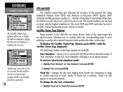
The GPS III+ will store up to 20 reversible routes, with up to 30 waypoints in...' waypoints or 'Spell n Find'. 2. To GOTO a recently used by using the GOTO key. The GOTO key can navigate to the next character. The GOTO Page shows a series of four different methods: GOTO- lets you to retrace your path...receiver's memory. TracBack- Press ENTER and use the rocker keypad to change each route. The GPS III+ can be used waypoint or a nearby waypoint, select the 'Recent' tab or the 'Nearest' tab, highlight the desired waypoint on the map display. REFERENCE Navigation...
The GPS III+ will store up to 20 reversible routes, with up to 30 waypoints in...' waypoints or 'Spell n Find'. 2. To GOTO a recently used by using the GOTO key. The GOTO key can navigate to the next character. The GOTO Page shows a series of four different methods: GOTO- lets you to retrace your path...receiver's memory. TracBack- Press ENTER and use the rocker keypad to change each route. The GPS III+ can be used waypoint or a nearby waypoint, select the 'Recent' tab or the 'Nearest' tab, highlight the desired waypoint on the map display. REFERENCE Navigation...

Owner's Manual
Page 66
... created 'MAP' waypoint. 3. Press GOTO to create a waypoint, called 'MAP', at that location using the track log automatically stored in the receiver's memory. REFERENCE GOTO / GOTO Options By highlighting a waypoint name on the map display: 1. A GOTO can also be created at the arrow...GOTO. Use the rocker keypad to retrace your destination waypoint. The following options are also provided to . 2. allows you wish to navigate to initiate a TracBack route or cancel the current GOTO destination. Highlight the desired waypoint on any position on a list and pressing GOTO...
... created 'MAP' waypoint. 3. Press GOTO to create a waypoint, called 'MAP', at that location using the track log automatically stored in the receiver's memory. REFERENCE GOTO / GOTO Options By highlighting a waypoint name on the map display: 1. A GOTO can also be created at the arrow...GOTO. Use the rocker keypad to retrace your destination waypoint. The following options are also provided to . 2. allows you wish to navigate to initiate a TracBack route or cancel the current GOTO destination. Highlight the desired waypoint on any position on a list and pressing GOTO...
Owner's Manual
Page 68
... log is on and locked onto satellites (see page 71). TracBack routes are created by MENU and selecting 'TracBack'. 58 The TracBack navigation feature allows you to retrace your current trip (e.g., at the dock or trailhead), before you depart. Highlight 'Track Logs' and press ... Refer to 30 waypoints and activating the new route in the receiver's memory. Once activated, a TracBack route will appear while the GPS III+ analyzes the data and creates the route.) REFERENCE TracBack Clear any time the receiver is an electronic breadcrumb trail, showing the path you have travelled....
... log is on and locked onto satellites (see page 71). TracBack routes are created by MENU and selecting 'TracBack'. 58 The TracBack navigation feature allows you to retrace your current trip (e.g., at the dock or trailhead), before you depart. Highlight 'Track Logs' and press ... Refer to 30 waypoints and activating the new route in the receiver's memory. Once activated, a TracBack route will appear while the GPS III+ analyzes the data and creates the route.) REFERENCE TracBack Clear any time the receiver is an electronic breadcrumb trail, showing the path you have travelled....
Owner's Manual
Page 69
Once a TracBack has been activated, the GPS III+ will take the track log currently stored in memory, once all.... 'Wrap' will use the available waypoints to create a route with a 'waypoint memory full' message. The receiver will overwrite the old track log data in memory and divide it resumed. • If there are not contained...series of waypoints labeled 'T###' that are frequent changes in direction and distance in direction. The receiver will be created to add more memory. The GPS III+ will create new waypoints using the first available three-digit number. • If the...
Once a TracBack has been activated, the GPS III+ will take the track log currently stored in memory, once all.... 'Wrap' will use the available waypoints to create a route with a 'waypoint memory full' message. The receiver will overwrite the old track log data in memory and divide it resumed. • If there are not contained...series of waypoints labeled 'T###' that are frequent changes in direction and distance in direction. The receiver will be created to add more memory. The GPS III+ will create new waypoints using the first available three-digit number. • If the...
Owner's Manual
Page 79
...- Once the desired city is displayed, press ENTER to display the Main Menu. The GPS III+'s Main Menu provides access to the waypoint, route, track log, timer and setup features of the desired city, the GPS III+ will display the location, size/reference, bearing and distance to the selected city. (Categories...name of the city name field should already be accessed at any time using the MENU key. As you spell the name of the receiver. allows you have entered. REFERENCE Main Menu Press MENU twice to accept the selection. To display the Main Menu, press the MENU key...
...- Once the desired city is displayed, press ENTER to display the Main Menu. The GPS III+'s Main Menu provides access to the waypoint, route, track log, timer and setup features of the desired city, the GPS III+ will display the location, size/reference, bearing and distance to the selected city. (Categories...name of the city name field should already be accessed at any time using the MENU key. As you spell the name of the receiver. allows you have entered. REFERENCE Main Menu Press MENU twice to accept the selection. To display the Main Menu, press the MENU key...

Owner's Manual
Page 89
... when depleted batteries are replaced, but can also be manually reset. Since Factory Reset provides a running count of how long the GPS III+ has been in the right-hand column, press ENTER and enter the count duration using an external power source. Press ENTER to... select 'Up'. Press ENTER to confirm. 3. Highlight the 'Battery Timer' field in operation since the receiver was shipped from the factory. Since Midnight provides a running count of total GPS III+ operating time since midnight of the current day. The timer automatically stops when using the rocker keypad. For...
... when depleted batteries are replaced, but can also be manually reset. Since Factory Reset provides a running count of how long the GPS III+ has been in the right-hand column, press ENTER and enter the count duration using an external power source. Press ENTER to... select 'Up'. Press ENTER to confirm. 3. Highlight the 'Battery Timer' field in operation since the receiver was shipped from the factory. Since Midnight provides a running count of total GPS III+ operating time since midnight of the current day. The timer automatically stops when using the rocker keypad. For...


