Owner's Manual
Page 2
...Dakota™ and myGarmin™ are registered trademarks of Groundspeak Inc., in the United States and other countries. or its subsidiaries Garmin International, Inc. 1200 East 151st Street, Olathe, Kansas 66062, USA Tel. (913) 397.8200 or (800) 800.1020 Fax (913) 397.8282 Garmin (Europe) Ltd. The Geocaching... or organization of this copyright notice and provided further that any purpose without the express prior written consent of geocaching.com data is a trademark of Garmin. May 2009 Part Number 190-01069-00 Rev. Used with permission. microSD™ is subject to change ...
...Dakota™ and myGarmin™ are registered trademarks of Groundspeak Inc., in the United States and other countries. or its subsidiaries Garmin International, Inc. 1200 East 151st Street, Olathe, Kansas 66062, USA Tel. (913) 397.8200 or (800) 800.1020 Fax (913) 397.8282 Garmin (Europe) Ltd. The Geocaching... or organization of this copyright notice and provided further that any purpose without the express prior written consent of geocaching.com data is a trademark of Garmin. May 2009 Part Number 190-01069-00 Rev. Used with permission. microSD™ is subject to change ...

Owner's Manual
Page 5
GPS Games 20 Geocaches 20 Customizing the Dakota... 21 Changing the Profile 21 Setting Up Profiles 21 Using System Setup 22 Customizing the Display.......... 22 Map Setup 23 Track Setup 24 Customizing the ... Changing Measurement Units. 26 Position Format 27 Modifying the Compass........... 27 Altimeter Setup 28 Pairing the Dakota 29 Reset 30 Viewing Your Dakota Information 30 Appendix 31 Introduction Specifications 31 Using Demo Mode 32 Connecting Your Dakota to a Computer........... 33 Installing a microSD™ Card 33 Transferring Tracks, Routes, or Waypoints 34 Loading and...
GPS Games 20 Geocaches 20 Customizing the Dakota... 21 Changing the Profile 21 Setting Up Profiles 21 Using System Setup 22 Customizing the Display.......... 22 Map Setup 23 Track Setup 24 Customizing the ... Changing Measurement Units. 26 Position Format 27 Modifying the Compass........... 27 Altimeter Setup 28 Pairing the Dakota 29 Reset 30 Viewing Your Dakota Information 30 Appendix 31 Introduction Specifications 31 Using Demo Mode 32 Connecting Your Dakota to a Computer........... 33 Installing a microSD™ Card 33 Transferring Tracks, Routes, or Waypoints 34 Loading and...

Owner's Manual
Page 23
... indicates when it is ready to calculate. 3. Walk around the perimeter of the area you want to receive data. 4. On the sending unit, touch Send. 5. On the sending unit, touch an item to send. 6. Calculating the Size of ...routes, tracks, and geocaches with the Dakota 10. On the Main menu of data to send and touch Send. 7. Touch Area Calculation > Start. 2. Both units indicate that the transfer is complete. 8. Additional Tools Sharing Information Wirelessly note: Sharing information wirelessly is unavailable with another wirelessenabled Garmin recreational handheld. 1....
... indicates when it is ready to calculate. 3. Walk around the perimeter of the area you want to receive data. 4. On the sending unit, touch Send. 5. On the sending unit, touch an item to send. 6. Calculating the Size of ...routes, tracks, and geocaches with the Dakota 10. On the Main menu of data to send and touch Send. 7. Touch Area Calculation > Start. 2. Both units indicate that the transfer is complete. 8. Additional Tools Sharing Information Wirelessly note: Sharing information wirelessly is unavailable with another wirelessenabled Garmin recreational handheld. 1....
Owner's Manual
Page 25
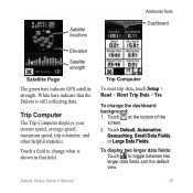
... and other helpful statistics. To change what is still collecting data. Dakota Series Owner's Manual 19 Satellite locations Additional Tools Dashboard Elevation Satellite strength Satellite Page The green bars indicate GPS satellite strength. Touch at the bottom of the screen. 2. To display... two larger data fields: Touch to change the dashboard background: 1. White bars indicate that the Dakota is shown in that field. Touch Default, Automotive, Geocaching, Small Data Fields...
... and other helpful statistics. To change what is still collecting data. Dakota Series Owner's Manual 19 Satellite locations Additional Tools Dashboard Elevation Satellite strength Satellite Page The green bars indicate GPS satellite strength. Touch at the bottom of the screen. 2. To display... two larger data fields: Touch to change the dashboard background: 1. White bars indicate that the Dakota is shown in that field. Touch Default, Automotive, Geocaching, Small Data Fields...
Owner's Manual
Page 26
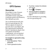
... to navigate to your course. 4. Touch > Compass. 5. The Web site supports the transfer of treasure hunting in from www.geocaching.com. Touch Geocaches > Find a Geocache. 2. You can download Geocache sites from www.garmin.com/products /communicator, you can download geocaches directly to a geocache using GPS coordinates posted on geocaching, visit www.geocaching.com. 20 Dakota Series Owner's Manual To navigate to your...
... to navigate to your course. 4. Touch > Compass. 5. The Web site supports the transfer of treasure hunting in from www.geocaching.com. Touch Geocaches > Find a Geocache. 2. You can download Geocache sites from www.garmin.com/products /communicator, you can download geocaches directly to a geocache using GPS coordinates posted on geocaching, visit www.geocaching.com. 20 Dakota Series Owner's Manual To navigate to your...
Owner's Manual
Page 40
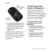
...Routes, or Waypoints Tracks, routes, and waypoints (including geocache sites) can be transferred between your computer. 3. Connect the Dakota to store files such as Google™ Maps. Open MapSource on the MapSource Transfer menu. 34 Dakota Series Owner's Manual To remove the microSD card, lift ...: 1. Replace the batteries and the battery cover. Click Receive From Device or Send To Device on your Dakota and computer maps such as MapSource or maps accessed on mapping Web sites, such as images, cartridges, geocaches, routes, waypoints, and custom POIs. To transfer tracks,...
...Routes, or Waypoints Tracks, routes, and waypoints (including geocache sites) can be transferred between your computer. 3. Connect the Dakota to store files such as Google™ Maps. Open MapSource on the MapSource Transfer menu. 34 Dakota Series Owner's Manual To remove the microSD card, lift ...: 1. Replace the batteries and the battery cover. Click Receive From Device or Send To Device on your Dakota and computer maps such as MapSource or maps accessed on mapping Web sites, such as images, cartridges, geocaches, routes, waypoints, and custom POIs. To transfer tracks,...

Owner's Manual
Page 46
Index F factory settings 36 fitness setup 29 fixed elevation 28 G geocaches 20 GPS setting 22 grid north 27 guidance method 24 H heart rate monitor 29 hunt and fish 18 L language 22 light sectors 25 lock on road 25 ... measurement 26 profiles 21 R recent finds 5 record method, tracks 24 reverse route points 14 routes calculate 25 edit 13 reverse 14 setup 24 view 14 Dakota Series Owner's Manual
Index F factory settings 36 fitness setup 29 fixed elevation 28 G geocaches 20 GPS setting 22 grid north 27 guidance method 24 H heart rate monitor 29 hunt and fish 18 L language 22 light sectors 25 lock on road 25 ... measurement 26 profiles 21 R recent finds 5 record method, tracks 24 reverse route points 14 routes calculate 25 edit 13 reverse 14 setup 24 view 14 Dakota Series Owner's Manual


