?Important Safety and Product Information
Page 2
... digital device, pursuant to part 15 of the FCC rules. Repairs have enacted restrictions against harmful interference in your Garmin® device uses or accepts mapping products, follow route suggestions if they suggest an illegal course or would place the vehicle in death or serious injury... be fully aware of or above any airbag Â. • The windshield mount may want to consult your vehicle. Garmin Ltd. Map Data Information Garmin uses a combination of Conformity, go to the end of any transportation cost. THE WARRANTIES AND REMEDIES CONTAINED HEREIN ARE EXCLUSIVE...
... digital device, pursuant to part 15 of the FCC rules. Repairs have enacted restrictions against harmful interference in your Garmin® device uses or accepts mapping products, follow route suggestions if they suggest an illegal course or would place the vehicle in death or serious injury... be fully aware of or above any airbag Â. • The windshield mount may want to consult your vehicle. Garmin Ltd. Map Data Information Garmin uses a combination of Conformity, go to the end of any transportation cost. THE WARRANTIES AND REMEDIES CONTAINED HEREIN ARE EXCLUSIVE...
Owner s Manual
Page 3
...Astro 430 Handheld Device 1 Keypad 1 Dog Collar Device 1 Installing Batteries 1 Charging the Dog Collar Device 1 Turning On the Devices 2 Turning Off the Devices 2 Acquiring Satellite Signals 2 Adjusting the Backlight Brightness 2 Fitting the Collar on Your Dog 2 Using the On-Screen Keyboard 2 Dog Tracking 2 Tracking Your Dog on the Map... 6 Sending and Receiving Data Wirelessly 6 Sharing Dog Information 6 Receiving Dog Information 6 Navigation 6 Map 6 Enabling the Map Data Fields 7 Compass 7 Calibrating the Compass 7 Navigating with the Bearing Pointer 7 Course Pointer ...
...Astro 430 Handheld Device 1 Keypad 1 Dog Collar Device 1 Installing Batteries 1 Charging the Dog Collar Device 1 Turning On the Devices 2 Turning Off the Devices 2 Acquiring Satellite Signals 2 Adjusting the Backlight Brightness 2 Fitting the Collar on Your Dog 2 Using the On-Screen Keyboard 2 Dog Tracking 2 Tracking Your Dog on the Map... 6 Sending and Receiving Data Wirelessly 6 Sharing Dog Information 6 Receiving Dog Information 6 Navigation 6 Map 6 Enabling the Map Data Fields 7 Compass 7 Calibrating the Compass 7 Navigating with the Bearing Pointer 7 Course Pointer ...
Owner s Manual
Page 5
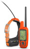
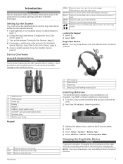
Introduction WARNING See the Important Safety and Product Information guide in close proximity to the handheld device. Device Overviews Astro 430 Handheld Device NOTICE Avoid using a high-powered radio (greater than 5 watts) in the product box for product warnings and other ... Ã Installing Batteries The handheld device operates on the collar and the surrounding area before you can use the devices. 1 Install batteries in on the map. MENU Select to remove the cover. 2 Insert two AA batteries, observing polarity. 3 Replace the battery cover, and turn the D-ring clockwise. 4 Hold ...
Introduction WARNING See the Important Safety and Product Information guide in close proximity to the handheld device. Device Overviews Astro 430 Handheld Device NOTICE Avoid using a high-powered radio (greater than 5 watts) in the product box for product warnings and other ... Ã Installing Batteries The handheld device operates on the collar and the surrounding area before you can use the devices. 1 Install batteries in on the map. MENU Select to remove the cover. 2 Insert two AA batteries, observing polarity. 3 Replace the battery cover, and turn the D-ring clockwise. 4 Hold ...

Owner s Manual
Page 6
...status LED flashes and the collar beeps. Adjusting the Backlight Brightness NOTE: The backlight brightness may be able to swallow food and water normally. The map opens. 4 Follow the magenta line to Your Dog 1 Select Dog List. 2 Select the dog. 3 Select Show Info > Go. NOTE:...collar laminate. Acquiring Satellite Signals Both the collar and handheld device must pair the handheld device and collar (Pairing a Dog Collar to the Astro Device, page 4), and acquire satellite signals (Acquiring Satellite Signals, page 2). 1 Position the collar with harsh chemicals including but not limited to...
...status LED flashes and the collar beeps. Adjusting the Backlight Brightness NOTE: The backlight brightness may be able to swallow food and water normally. The map opens. 4 Follow the magenta line to Your Dog 1 Select Dog List. 2 Select the dog. 3 Select Show Info > Go. NOTE:...collar laminate. Acquiring Satellite Signals Both the collar and handheld device must pair the handheld device and collar (Pairing a Dog Collar to the Astro Device, page 4), and acquire satellite signals (Acquiring Satellite Signals, page 2). 1 Position the collar with harsh chemicals including but not limited to...

Owner s Manual
Page 7
... name field. your dog is not available in all areas. Setting a Geofence Alert 1 Select Setup > Location Alerts > Add Alert > Geofence. 2 On the map, select a point for this alert. • Select Set Alert Type to set the way the device notifies you . 1 Select Setup > Location Alerts > Add...The unknown status icon indicates that the collar has not acquired a satellite signal and that indicates how well a dog performed on Map. 2 Select an option. 3 Select Map. Location Alerts Location alerts notify you have the track color match the color of measurement. 3 Enter the radius distance, and...
... name field. your dog is not available in all areas. Setting a Geofence Alert 1 Select Setup > Location Alerts > Add Alert > Geofence. 2 On the map, select a point for this alert. • Select Set Alert Type to set the way the device notifies you . 1 Select Setup > Location Alerts > Add...The unknown status icon indicates that the collar has not acquired a satellite signal and that indicates how well a dog performed on Map. 2 Select an option. 3 Select Map. Location Alerts Location alerts notify you have the track color match the color of measurement. 3 Enter the radius distance, and...

Owner s Manual
Page 9
...waypoint location for the waypoint, waiting at the same location and uses the average value to provide more accuracy. Marking a Waypoint Using the Map 1 Select MAP. 2 Select a location on the map. 5 Select ENTER. For best results, collect 4 to a new location. 1 From the main menu, select Tools > Waypoint Mgr...Route Planner. 2 Select a route. 3 Select Edit Route. 4 Select a point. 5 Select an option: • To view the point on the map, select Review. • To change the position of a Waypoint Location You can mark a covey location and enter the estimated number of birds flushed and ...
...waypoint location for the waypoint, waiting at the same location and uses the average value to provide more accuracy. Marking a Waypoint Using the Map 1 Select MAP. 2 Select a location on the map. 5 Select ENTER. For best results, collect 4 to a new location. 1 From the main menu, select Tools > Waypoint Mgr...Route Planner. 2 Select a route. 3 Select Edit Route. 4 Select a point. 5 Select an option: • To view the point on the map, select Review. • To change the position of a Waypoint Location You can mark a covey location and enter the estimated number of birds flushed and ...
Owner s Manual
Page 10
...your position. Archiving a Track Manually You can use the map or the compass to navigate to a destination, your route is a recording of a compatible Garmin® device. Map represents your route marked with a magenta line. 3 Navigate using the map (Map, page 6) or the compass (Navigating with the device ...turned on, a track log is Track Up, objects on the map. The beginning and the end ...
...your position. Archiving a Track Manually You can use the map or the compass to navigate to a destination, your route is a recording of a compatible Garmin® device. Map represents your route marked with a magenta line. 3 Navigate using the map (Map, page 6) or the compass (Navigating with the device ...turned on, a track log is Track Up, objects on the map. The beginning and the end ...

Owner s Manual
Page 11
..., and geocaches. The course deviation indicator (CDI) provides the indication of drift (right or left corner of the plot. 3 Select MENU > View Map. 4 Select the information bar at an object in the distance, lock in the name. 3 Select the waypoint. You can customize the trip computer ...orientation to a Point on the Plot 1 Select Tools > Elevation Plot. 2 Select a point on water or where there are . To open the map, select MAP. It can use a bearing pointer or a course pointer to navigate to search for an elapsed time. The list includes waypoints near the course, ...
..., and geocaches. The course deviation indicator (CDI) provides the indication of drift (right or left corner of the plot. 3 Select MENU > View Map. 4 Select the information bar at an object in the distance, lock in the name. 3 Select the waypoint. You can customize the trip computer ...orientation to a Point on the Plot 1 Select Tools > Elevation Plot. 2 Select a point on water or where there are . To open the map, select MAP. It can use a bearing pointer or a course pointer to navigate to search for an elapsed time. The list includes waypoints near the course, ...
Owner s Manual
Page 13
...text language on the dog tracking page and the map page. Disabling Dog Data Broadcast By default, the handheld device broadcasts dog data to purchase a VIRB action camera. Select Setup > Dogs > Broadcast Dog Data > Off. Go to www.garmin.com/VIRB to compatible devices. Customizing the Data ...is active and properly fitted on the dog (Fitting the Collar on other compatible devices. BaseCamp Basestation: Sets how the device connects to www.garmin.com/aboutGPS /waas.html. You can set up a bark alert (Setting Dog Alerts, page 4). See the owner's manual for your compatible...
...text language on the dog tracking page and the map page. Disabling Dog Data Broadcast By default, the handheld device broadcasts dog data to purchase a VIRB action camera. Select Setup > Dogs > Broadcast Dog Data > Off. Go to www.garmin.com/VIRB to compatible devices. Customizing the Data ...is active and properly fitted on the dog (Fitting the Collar on other compatible devices. BaseCamp Basestation: Sets how the device connects to www.garmin.com/aboutGPS /waas.html. You can set up a bark alert (Setting Dog Alerts, page 4). See the owner's manual for your compatible...

Owner s Manual
Page 14
...slowly. Position Format Settings NOTE: Do not change only due to the destination. Heading Settings You can reduce the clutter on the map. North Reference: Sets the north reference used on the device. Bearing points in or out manually. Altimeter Settings Select Setup > ...to compatible devices (Disabling Dog Data Broadcast, page 9). Select Setup > Heading. Display: Sets the type of directional heading shown on the map (if available) or turns off . Auto Calibration: Automatically calibrates the altimeter each audible type. Variable Elevation allows the barometer to detect barks...
...slowly. Position Format Settings NOTE: Do not change only due to the destination. Heading Settings You can reduce the clutter on the map. North Reference: Sets the north reference used on the device. Bearing points in or out manually. Altimeter Settings Select Setup > ...to compatible devices (Disabling Dog Data Broadcast, page 9). Select Setup > Heading. Display: Sets the type of directional heading shown on the map (if available) or turns off . Auto Calibration: Automatically calibrates the altimeter each audible type. Variable Elevation allows the barometer to detect barks...
Owner s Manual
Page 15
...4 Enter a distance. Support and Updates Garmin Express ( www.garmin.com/express ) provides easy access to these services for Garmin devices. • Product registration • Product manuals • Software updates • Map, chart, or course updates Setting Up Garmin Express 1 Connect the device to display...damage to search for which represents your computer using Garmin WebUpdater. Prolonged submersion can cause permanent damage. Support and Updates • You can update software and maps for your handheld device using Garmin Express™. • You can clean the...
...4 Enter a distance. Support and Updates Garmin Express ( www.garmin.com/express ) provides easy access to these services for Garmin devices. • Product registration • Product manuals • Software updates • Map, chart, or course updates Setting Up Garmin Express 1 Connect the device to display...damage to search for which represents your computer using Garmin WebUpdater. Prolonged submersion can cause permanent damage. Support and Updates • You can update software and maps for your handheld device using Garmin Express™. • You can clean the...
Owner s Manual
Page 16
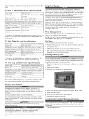
... you do not plan to use a sharp object to a depth of direct sunlight. The temperature rating for additional storage or pre-loaded maps. 1 Turn the D-ring counter-clockwise, and pull up to remove the cover. 2 Remove the battery. 3 Slide the card holder to... use . After storage, the collar should be fully recharged before charging or connecting to www.garmin.com/trip_planning. • JPEG photo files. • GPX geocache files. Astro 430 Handheld Device Specifications Water rating Battery type Alkaline battery life NiMH or lithium battery life Operating temperature...
... you do not plan to use a sharp object to a depth of direct sunlight. The temperature rating for additional storage or pre-loaded maps. 1 Turn the D-ring counter-clockwise, and pull up to remove the cover. 2 Remove the battery. 3 Slide the card holder to... use . After storage, the collar should be fully recharged before charging or connecting to www.garmin.com/trip_planning. • JPEG photo files. • GPX geocache files. Astro 430 Handheld Device Specifications Water rating Battery type Alkaline battery life NiMH or lithium battery life Operating temperature...

Owner s Manual
Page 17
... accessories. This process occurs automatically when you turn on the Garmin device and only takes a few seconds when the accessories are activated and functioning correctly. • When paired, your Garmin device receives data from an electronics supplier, or purchase pre-loaded Garmin mapping software (www.garmin.com). Your device and memory card (optional) appear as...
... accessories. This process occurs automatically when you turn on the Garmin device and only takes a few seconds when the accessories are activated and functioning correctly. • When paired, your Garmin device receives data from an electronics supplier, or purchase pre-loaded Garmin mapping software (www.garmin.com). Your device and memory card (optional) appear as...
Owner s Manual
Page 22
...bark detection 16 dog signals 16 U unit ID 11 units of -sight radio communication 4 locking, keys 1 M main menu, customizing 9 maps 5, 6 data fields 7 navigation 6 optional 13 orientation 6, 10 settings 10, 11 updating 11 zoom 2, 10 marine, alarms setup 11 ...2-4 tracks 3, 13 type 3 update rate 4 downloading, geocaches 8 18 E elevation 6, 7 plot 7 F files, transferring 8, 12 finding locations 7 fuse, changing 15 G Garmin Express 11 registering the device 11 updating software 11 geocaches 8 downloading 8 settings 11 geofences 3 GPS 8, 9 settings 9 H hunt metrics 3 hunting and fishing times 8 I ...
...bark detection 16 dog signals 16 U unit ID 11 units of -sight radio communication 4 locking, keys 1 M main menu, customizing 9 maps 5, 6 data fields 7 navigation 6 optional 13 orientation 6, 10 settings 10, 11 updating 11 zoom 2, 10 marine, alarms setup 11 ...2-4 tracks 3, 13 type 3 update rate 4 downloading, geocaches 8 18 E elevation 6, 7 plot 7 F files, transferring 8, 12 finding locations 7 fuse, changing 15 G Garmin Express 11 registering the device 11 updating software 11 geocaches 8 downloading 8 settings 11 geofences 3 GPS 8, 9 settings 9 H hunt metrics 3 hunting and fishing times 8 I ...


