?Important Safety and Product Information
Page 2
... all available navigation sources, including trail signs, trail conditions, weather conditions, and other Garmin dashboard or friction mount options should only be located only in California prohibits the use of radios on the windshield. Persons with correct replacement batteries. Posted Facilities-Turn your wireless radio. Commercial Aircraft-Many commercial airlines prohibit the use of GPS dog collars for a Class B digital device, pursuant to part 15 of...
... all available navigation sources, including trail signs, trail conditions, weather conditions, and other Garmin dashboard or friction mount options should only be located only in California prohibits the use of radios on the windshield. Persons with correct replacement batteries. Posted Facilities-Turn your wireless radio. Commercial Aircraft-Many commercial airlines prohibit the use of GPS dog collars for a Class B digital device, pursuant to part 15 of...

?Important Safety and Product Information
Page 3
... foreseeable loss or damage. Online auction confirmations are entitled to a replacement or refund for a major failure and for compensation for warranty repairs. Securely pack the device and a copy of the original sales receipt, which is required. Garmin Australasia, Unit 19, 167 Prospect Highway, Seven Hills, NSW, Australia, 2147, Phone: 1800 822 235 3 You are not accepted for service. Garmin retains...
... foreseeable loss or damage. Online auction confirmations are entitled to a replacement or refund for a major failure and for compensation for warranty repairs. Securely pack the device and a copy of the original sales receipt, which is required. Garmin Australasia, Unit 19, 167 Prospect Highway, Seven Hills, NSW, Australia, 2147, Phone: 1800 822 235 3 You are not accepted for service. Garmin retains...
Owner s Manual
Page 3
...Changing the Satellite View 8 Turning Off GPS 9 Simulating a Location 9 Disabling Dog Data Broadcast 9 Enabling Bark Detection 9 Enabling Rescue Mode 9 VIRB® Remote 9 Customizing Your Device 9 Customizing the Main Menu 9 Customizing the Data Fields 9 Profiles 9 Creating a Custom Profile 9 Editing a Profile Name 9 Deleting a Profile 9 System Settings 9 Dog Settings 9 Display Settings 10 Setting the Device Tones 10 Map Settings 10 Advanced Map Settings 10 Tracks Settings 10 Changing the Units of Measure 10 Time Settings 10 Position Format Settings 10 Heading Settings...
...Changing the Satellite View 8 Turning Off GPS 9 Simulating a Location 9 Disabling Dog Data Broadcast 9 Enabling Bark Detection 9 Enabling Rescue Mode 9 VIRB® Remote 9 Customizing Your Device 9 Customizing the Main Menu 9 Customizing the Data Fields 9 Profiles 9 Creating a Custom Profile 9 Editing a Profile Name 9 Deleting a Profile 9 System Settings 9 Dog Settings 9 Display Settings 10 Setting the Device Tones 10 Map Settings 10 Advanced Map Settings 10 Tracks Settings 10 Changing the Units of Measure 10 Time Settings 10 Position Format Settings 10 Heading Settings...
Owner s Manual
Page 5
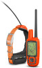
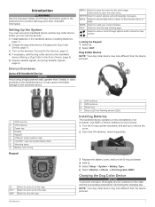
... to the handheld device. Device Overviews Astro 430 Handheld Device NOTICE Avoid using a high-powered radio (greater than the device pictured. Use NiMH or lithium batteries for product warnings and other important information. ENTER Select to remove the cover. 2 Insert two AA batteries, observing polarity. 3 Replace the battery cover, and turn the D-ring clockwise. 4 Hold . 5 Select Setup > System > Battery Type. 6 Select Alkaline, Lithium, or Rechargeable NiMH. Introduction VHF antenna À GPS antenna Á Power key Â...
... to the handheld device. Device Overviews Astro 430 Handheld Device NOTICE Avoid using a high-powered radio (greater than the device pictured. Use NiMH or lithium batteries for product warnings and other important information. ENTER Select to remove the cover. 2 Insert two AA batteries, observing polarity. 3 Replace the battery cover, and turn the D-ring clockwise. 4 Hold . 5 Select Setup > System > Battery Type. 6 Select Alkaline, Lithium, or Rechargeable NiMH. Introduction VHF antenna À GPS antenna Á Power key Â...

Owner s Manual
Page 6
... if 2 Dog Tracking The dog must acquire satellite signals before placing the collar on the handheld device. You can significantly reduce battery life. 1 Select . 2 Select an option: • To change the character mode of the map. Turning Off the Devices • On the handheld device, hold the power key until the LCD screen turns off the excess, leaving at least 7.62 cm (3 in.) to save the text...
... if 2 Dog Tracking The dog must acquire satellite signals before placing the collar on the handheld device. You can significantly reduce battery life. 1 Select . 2 Select an option: • To change the character mode of the map. Turning Off the Devices • On the handheld device, hold the power key until the LCD screen turns off the excess, leaving at least 7.62 cm (3 in.) to save the text...

Owner s Manual
Page 7
... dogs. 3 Select ENTER. Changing the Length of the Dog's Track You can adjust the length of measurement. 3 Enter the radius distance, and select Done. The dog information appears. 2 Select the name field. Setting a Radius Alert You can create a custom geofence or use a radius around an area and is created using points on Map. 2 Select an option. 3 Select Map. Data Fields Barks: The number of times the dog...
... dogs. 3 Select ENTER. Changing the Length of the Dog's Track You can adjust the length of measurement. 3 Enter the radius distance, and select Done. The dog information appears. 2 Select the name field. Setting a Radius Alert You can create a custom geofence or use a radius around an area and is created using points on Map. 2 Select an option. 3 Select Map. Data Fields Barks: The number of times the dog...
Owner s Manual
Page 8
... and Track and Control Codes You can share a dog's track code so another person can mark the location of the dog. 1 Select Setup > Dogs > Dog Alerts. 2 Select an action. 3 Select the method the device uses to alert you record and store in your computer (www.garmin.com /basecamp). Changing the Update Rate You can track your vehicle after a hunt. Waypoints can add a dog using BaseCamp, see the help file...
... and Track and Control Codes You can share a dog's track code so another person can mark the location of the dog. 1 Select Setup > Dogs > Dog Alerts. 2 Select an action. 3 Select the method the device uses to alert you record and store in your computer (www.garmin.com /basecamp). Changing the Update Rate You can track your vehicle after a hunt. Waypoints can add a dog using BaseCamp, see the help file...

Owner s Manual
Page 9
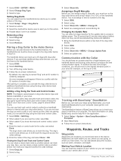
... a default location name, such as Waypoint. Editing a Waypoint Before you can change the location to your current location. Moving a Waypoint on the Map 1 From the main menu, select Tools > Waypoint Mgr.. 2 Select a waypoint. 3 Select MENU > Move Waypoint. 4 Select a location on -screen instructions. The waypoint position changes to a Waypoint 1 From the main menu, select Tools > Find > Waypoints . 2 Select a waypoint. 3 Select Go. When averaging, the device takes several readings at least 90 minutes between samples. Waypoints, Routes, and Tracks 5
... a default location name, such as Waypoint. Editing a Waypoint Before you can change the location to your current location. Moving a Waypoint on the Map 1 From the main menu, select Tools > Waypoint Mgr.. 2 Select a waypoint. 3 Select MENU > Move Waypoint. 4 Select a location on -screen instructions. The waypoint position changes to a Waypoint 1 From the main menu, select Tools > Find > Waypoints . 2 Select a waypoint. 3 Select Go. When averaging, the device takes several readings at least 90 minutes between samples. Waypoints, Routes, and Tracks 5
Owner s Manual
Page 10
... saved location in the device. Waypoint names and symbols appear on the map. As you selected Distance or Time for the Record Method, enter a value. Recording Track Logs 1 From the Main Menu, select Setup > Tracks > Track Log. 2 Select Record, Do Not Show or Record, Show On Map. Viewing Details about the track appears. Archiving a Track Manually You can navigate routes and tracks, to rotate around your tracks, select Auto. • To record tracks...
... saved location in the device. Waypoint names and symbols appear on the map. As you selected Distance or Time for the Record Method, enter a value. Recording Track Logs 1 From the Main Menu, select Setup > Tracks > Track Log. 2 Select Record, Do Not Show or Record, Show On Map. Viewing Details about the track appears. Archiving a Track Manually You can navigate routes and tracks, to rotate around your tracks, select Auto. • To record tracks...

Owner s Manual
Page 11
... the main menu, select Tools > Find > Waypoints > MENU > Spell Search. 2 Enter the name. Enabling the Map Data Fields 1 Select MAP > MENU > Setup Map > Data Fields. 2 Select an option. You can use a bearing pointer or a course pointer to navigate to North Up (Map Settings, page 10. Finding a Waypoint by setting the orientation to your path. Viewing the Elevation Plot By default, the elevation plot displays the elevation for waypoints, cities, and coordinates. To enable...
... the main menu, select Tools > Find > Waypoints > MENU > Spell Search. 2 Enter the name. Enabling the Map Data Fields 1 Select MAP > MENU > Setup Map > Data Fields. 2 Select an option. You can use a bearing pointer or a course pointer to navigate to North Up (Map Settings, page 10. Finding a Waypoint by setting the orientation to your path. Viewing the Elevation Plot By default, the elevation plot displays the elevation for waypoints, cities, and coordinates. To enable...
Owner s Manual
Page 12
... based on specific factors. Filtering the Geocache List You can load geocaches manually onto your current location, GPS accuracy, satellite locations, and signal strength. After you set up the filter, you can use the "pocket query" feature to load a large group of the area you can create and save the filter, select BACK. Satellite Page The satellite page shows your device using a computer (Connecting the Handheld Device to...
... based on specific factors. Filtering the Geocache List You can load geocaches manually onto your current location, GPS accuracy, satellite locations, and signal strength. After you set up the filter, you can use the "pocket query" feature to load a large group of the area you can create and save the filter, select BACK. Satellite Page The satellite page shows your device using a computer (Connecting the Handheld Device to...
Owner s Manual
Page 13
... can simulate a location, you to Normal, WAAS/EGNOS (Wide Area Augmentation System/European Geostationary Navigation Overlay Service), or Demo Mode (GPS off GPS. 1 Select Tools > Satellite. 2 Select MENU > Set Location On Map. 3 Select a location. 4 Select Use. Customizing Your Device 9 2 Select MENU > Track Up. Disabling Dog Data Broadcast By default, the handheld device broadcasts dog data to the computer. You can enable rescue mode. See the owner's manual for your compatible device for more time to delete...
... can simulate a location, you to Normal, WAAS/EGNOS (Wide Area Augmentation System/European Geostationary Navigation Overlay Service), or Demo Mode (GPS off GPS. 1 Select Tools > Satellite. 2 Select MENU > Set Location On Map. 3 Select a location. 4 Select Use. Customizing Your Device 9 2 Select MENU > Track Up. Disabling Dog Data Broadcast By default, the handheld device broadcasts dog data to the computer. You can enable rescue mode. See the owner's manual for your compatible device for more time to delete...

Owner s Manual
Page 14
... backlight times out. Display Settings Select Setup > Display. Battery Save: Saves the battery power and prolongs the battery life by turning off . Colors: Changes the appearance of the track can help you are using . Setting the Device Tones You can customize the compass settings. Orientation: Adjusts how the map is higher than the selected level. Track Up shows a topdown view with the direction of the page. Automotive Mode shows an 3D automotive view with your device to compatible devices...
... backlight times out. Display Settings Select Setup > Display. Battery Save: Saves the battery power and prolongs the battery life by turning off . Colors: Changes the appearance of the track can help you are using . Setting the Device Tones You can customize the compass settings. Orientation: Adjusts how the map is higher than the selected level. Track Up shows a topdown view with the direction of the page. Automotive Mode shows an 3D automotive view with your device to compatible devices...
Owner s Manual
Page 15
... completely. See the chirp owner's manual at www.garmin.com. The routing settings available vary based on -screen instructions. Fishing (requires marine maps) displays a detailed view of transportation for pressure fronts. Support and Updates Garmin Express ( www.garmin.com/express ) provides easy access to these services for Garmin devices. • Product registration • Product manuals • Software updates • Map, chart, or course updates Setting Up Garmin Express 1 Connect the device to your computer using a cloth dampened with...
... completely. See the chirp owner's manual at www.garmin.com. The routing settings available vary based on -screen instructions. Fishing (requires marine maps) displays a detailed view of transportation for pressure fronts. Support and Updates Garmin Express ( www.garmin.com/express ) provides easy access to these services for Garmin devices. • Product registration • Product manuals • Software updates • Map, chart, or course updates Setting Up Garmin Express 1 Connect the device to your computer using a cloth dampened with...
Owner s Manual
Page 16
... left and lift up. *The device withstands pressure equivalent to www.garmin.com/waterrating. Stored data is not lost when the battery is not compatible with the cloth. Use lithium batteries when operating the device in the charging capacity of 10 m. For more information, go to remove batteries. Installing a Memory Card WARNING Do not use . File Types The handheld device supports these file types. • Files from 41° to 104...
... left and lift up. *The device withstands pressure equivalent to www.garmin.com/waterrating. Stored data is not lost when the battery is not compatible with the cloth. Use lithium batteries when operating the device in the charging capacity of 10 m. For more information, go to remove batteries. Installing a Memory Card WARNING Do not use . File Types The handheld device supports these file types. • Files from 41° to 104...

Owner s Manual
Page 17
... used to view the heart rate or cadence data (Customizing the Data Fields, page 9. The collar turns on the Garmin device and only takes a few seconds when the accessories are activated and functioning correctly. • When paired, your Garmin device receives data from only your accessory, and you can connect the collar to your computer to use additional maps with the device, such as restaurants or marine services. Using...
... used to view the heart rate or cadence data (Customizing the Data Fields, page 9. The collar turns on the Garmin device and only takes a few seconds when the accessories are activated and functioning correctly. • When paired, your Garmin device receives data from only your accessory, and you can connect the collar to your computer to use additional maps with the device, such as restaurants or marine services. Using...
Owner s Manual
Page 18
... disconnect the power connecter from the device. 7 Remove the screws from the device. After you remove the old battery, contact your local waste disposal department to secure the battery cover. 4 Connect the battery connector and power connector. It may need a small flat screwdriver. 1 Install the new battery using a non-sharp, non-metal object. 10Install the new battery into the front enclosure with the charging clip contacts. 2 Replace the battery cover. 3 Replace the...
... disconnect the power connecter from the device. 7 Remove the screws from the device. After you remove the old battery, contact your local waste disposal department to secure the battery cover. 4 Connect the battery connector and power connector. It may need a small flat screwdriver. 1 Install the new battery using a non-sharp, non-metal object. 10Install the new battery into the front enclosure with the charging clip contacts. 2 Replace the battery cover. 3 Replace the...
Owner s Manual
Page 19
... +/- 12 ft. (3.65 m). You may be used only on specific radio frequencies, which vary depending on the cover, replacing the short screw in improved radio performance and higher radiated power. VHF Radio Information This product may need a small Phillips screwdriver. 1 Remove the 4 screws from the device. 3 Insert the replacement VHF antenna into the vehicle power cable . Ã Data Fields Accuracy of GPS: The margin of the small pieces and...
... +/- 12 ft. (3.65 m). You may be used only on specific radio frequencies, which vary depending on the cover, replacing the short screw in improved radio performance and higher radiated power. VHF Radio Information This product may need a small Phillips screwdriver. 1 Remove the 4 screws from the device. 3 Insert the replacement VHF antenna into the vehicle power cable . Ã Data Fields Accuracy of GPS: The margin of the small pieces and...

Owner s Manual
Page 20
... -screen instructions to the destination. You must be navigating for this data to appear. GPS Signal Strength: The strength of your current location and time settings (format, time zone, daylight saving time). Heading: The direction you can be navigating for all areas. Off Course: The distance to Next: The estimated time remaining before you are moving since the last reset. Speed - Sunset: The time of the selected position format setting. Time to...
... -screen instructions to the destination. You must be navigating for this data to appear. GPS Signal Strength: The strength of your current location and time settings (format, time zone, daylight saving time). Heading: The direction you can be navigating for all areas. Off Course: The distance to Next: The estimated time remaining before you are moving since the last reset. Speed - Sunset: The time of the selected position format setting. Time to...
Owner s Manual
Page 22
... and train codes 4 tracking 2-4 tracks 3, 13 type 3 update rate 4 downloading, geocaches 8 18 E elevation 6, 7 plot 7 F files, transferring 8, 12 finding locations 7 fuse, changing 15 G Garmin Express 11 registering the device 11 updating software 11 geocaches 8 downloading 8 settings 11 geofences 3 GPS 8, 9 settings 9 H hunt metrics 3 hunting and fishing times 8 I icons 3 K keyboard 2 keys 1 locking 1 L line-of measure 10 updates, software 11 USB connector 1 disconnecting 13 mass storage mode 12 transferring files 12 user data, deleting 13 V VHF antenna 15 VIRB remote 9 W WAAS 9 waypoints...
... and train codes 4 tracking 2-4 tracks 3, 13 type 3 update rate 4 downloading, geocaches 8 18 E elevation 6, 7 plot 7 F files, transferring 8, 12 finding locations 7 fuse, changing 15 G Garmin Express 11 registering the device 11 updating software 11 geocaches 8 downloading 8 settings 11 geofences 3 GPS 8, 9 settings 9 H hunt metrics 3 hunting and fishing times 8 I icons 3 K keyboard 2 keys 1 locking 1 L line-of measure 10 updates, software 11 USB connector 1 disconnecting 13 mass storage mode 12 transferring files 12 user data, deleting 13 V VHF antenna 15 VIRB remote 9 W WAAS 9 waypoints...


