
Owners Manual
Page 2
... may not be viewed and to change or improve its products and to make changes in any storage medium, for current updates and supplemental information concerning the use and operation of this manual or any revision hereto is subject to print one copy of...person or organization of Garmin Ltd. Visit the Garmin Web site (www.garmin.com) for any revision to download a single copy of this manual onto a hard drive or other Garmin products. Garmin®, AutoLocate®, and StreetPilot® are registered trademarks of such changes or improvements. Garmin hereby grants permission to...
... may not be viewed and to change or improve its products and to make changes in any storage medium, for current updates and supplemental information concerning the use and operation of this manual or any revision hereto is subject to print one copy of...person or organization of Garmin Ltd. Visit the Garmin Web site (www.garmin.com) for any revision to download a single copy of this manual onto a hard drive or other Garmin products. Garmin®, AutoLocate®, and StreetPilot® are registered trademarks of such changes or improvements. Garmin hereby grants permission to...
Owners Manual
Page 9
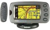
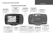
... 8-Bit Color LCD Touchscreen Display Keypad On-screen information is referred to upload software upgrades. USB Connector Interface unit with a PC to update your detail map and/ or add mapping software to the internal hard drive, or to as a 'page,' 'window,' or Controls ...to select a different page. Power/Speaker Connector Connector for optional external antenna. Front and Rear View of the StreetPilot Internal Patch Antenna Receives signals from remote control. Introducing the StreetPilot 2620/2660 Infrared Window Receives signals from GPS satellites to determine position.
... 8-Bit Color LCD Touchscreen Display Keypad On-screen information is referred to upload software upgrades. USB Connector Interface unit with a PC to update your detail map and/ or add mapping software to the internal hard drive, or to as a 'page,' 'window,' or Controls ...to select a different page. Power/Speaker Connector Connector for optional external antenna. Front and Rear View of the StreetPilot Internal Patch Antenna Receives signals from remote control. Introducing the StreetPilot 2620/2660 Infrared Window Receives signals from GPS satellites to determine position.

Owners Manual
Page 41
... other obstruction that , on the original route at right, will recalculate and update your destination. To cancel a detour, select Detour from your StreetPilot will appear. Your StreetPilot remembers detours you are in your requested distance; The StreetPilot will appear: Select Delete All to a roadblock or other roads exist that... you to suit more specific needs. Modifying a Route After you have practiced creating and saving simple routes, then you are navigating a route, you might want to opt for you are ready to learn how to modify them to take a detour...
... other obstruction that , on the original route at right, will recalculate and update your destination. To cancel a detour, select Detour from your StreetPilot will appear. Your StreetPilot remembers detours you are in your requested distance; The StreetPilot will appear: Select Delete All to a roadblock or other roads exist that... you to suit more specific needs. Modifying a Route After you have practiced creating and saving simple routes, then you are navigating a route, you might want to opt for you are ready to learn how to modify them to take a detour...
Owners Manual
Page 62
... who must be used at once. If necessary, you are an authorized Garmin installer for position, track, speed, etc. • None: Provides no interfacing capabilities. Change it to Garmin. If you plan to the StreetPilot's pre-programmed hard drive. • NMEA: Supports the input/output of USB....one of the information included in this format for software updates and to save mapping software to use both at one time; Reference Setting USB/Serial Formats StreetPilot 2660 Only You can change the settings below : • Garmin: The proprietary format used to transfer data via serial ...
... who must be used at once. If necessary, you are an authorized Garmin installer for position, track, speed, etc. • None: Provides no interfacing capabilities. Change it to Garmin. If you plan to the StreetPilot's pre-programmed hard drive. • NMEA: Supports the input/output of USB....one of the information included in this format for software updates and to save mapping software to use both at one time; Reference Setting USB/Serial Formats StreetPilot 2660 Only You can change the settings below : • Garmin: The proprietary format used to transfer data via serial ...
Owners Manual
Page 63
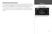
... the Info icon, and an Info page will appear. Software updates for registration and identification purposes. To access this page, press the StreetPilot MENU key; Reference Software Updates View your StreetPilot can be found periodically at our Web site at www.garmin.com. Obtaining the latest Software Upgrades The System Info page displays...
... the Info icon, and an Info page will appear. Software updates for registration and identification purposes. To access this page, press the StreetPilot MENU key; Reference Software Updates View your StreetPilot can be found periodically at our Web site at www.garmin.com. Obtaining the latest Software Upgrades The System Info page displays...

Owners Manual
Page 65
... sky view is not highlighted. • Hollow signal strength bar: The GPS receiver has found the satellite and is highlighted in your StreetPilot is being used indoors and cannot be used for navigation. 57 Once a fix has been calculated, the StreetPilot then updates your unit's last known position. The inner circle represents an elevation of...
... sky view is not highlighted. • Hollow signal strength bar: The GPS receiver has found the satellite and is highlighted in your StreetPilot is being used indoors and cannot be used for navigation. 57 Once a fix has been calculated, the StreetPilot then updates your unit's last known position. The inner circle represents an elevation of...

Owners Manual
Page 67
... distance (greater than 500 miles) from a North Up orientation to Track Up, which include accuracy. or have the unit automatically search for practice; Updating your StreetPilot. Accuracy The GPS Information page indicates the accuracy of satellites. The following options are available: Track Up/North Up, New Elevation, New Location, and Enable WAAS. Changes...
... distance (greater than 500 miles) from a North Up orientation to Track Up, which include accuracy. or have the unit automatically search for practice; Updating your StreetPilot. Accuracy The GPS Information page indicates the accuracy of satellites. The following options are available: Track Up/North Up, New Elevation, New Location, and Enable WAAS. Changes...
Owners Manual
Page 78
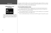
...512 MB of available space for your pre-programmed hard drive. This amount may be reduced as data updates occur. Menu page, touch the Select Map icon. Touch the map family you want the StreetPilot to use for the search, and it will need your Unit ID # (see page 55) ...information is indeed available in the other map family (or families). A list of cities or places only from Garmin and download the maps to your additional maps. Reference Adding Maps to your StreetPilot If information for a particular search is not available in another map family, a Select Map icon will appear ...
...512 MB of available space for your pre-programmed hard drive. This amount may be reduced as data updates occur. Menu page, touch the Select Map icon. Touch the map family you want the StreetPilot to use for the search, and it will need your Unit ID # (see page 55) ...information is indeed available in the other map family (or families). A list of cities or places only from Garmin and download the maps to your additional maps. Reference Adding Maps to your StreetPilot If information for a particular search is not available in another map family, a Select Map icon will appear ...
Owners Manual
Page 81
... Acquisition Times* Warm: Approximately 15 seconds Cold: Approximately 45 seconds AutoLocate: Approximately 2 minutes Update Rate: Once per second, continuous GPS Accuracy Position**: Physical Specifications Size: 5.6"W x 3.2"H x 2.0"D (14.3 x 8.0 x 5.0 cm) Weight: .93 pounds (420 g) Display: 3.3"W x 1.7"H (8.4 x 4.4 cm), (305 x 160 pixels), automotive-grade 8-bit, 256-color LCD with polarized sunglasses Case: Rugged; compatible with automatic dimming...
... Acquisition Times* Warm: Approximately 15 seconds Cold: Approximately 45 seconds AutoLocate: Approximately 2 minutes Update Rate: Once per second, continuous GPS Accuracy Position**: Physical Specifications Size: 5.6"W x 3.2"H x 2.0"D (14.3 x 8.0 x 5.0 cm) Weight: .93 pounds (420 g) Display: 3.3"W x 1.7"H (8.4 x 4.4 cm), (305 x 160 pixels), automotive-grade 8-bit, 256-color LCD with polarized sunglasses Case: Rugged; compatible with automatic dimming...

Owners Manual
Page 93
Garmin (Europe) Ltd. B or its subsidiaries Garmin International, Inc. 1200 East 151st Street, Olathe, Kansas 66062, U.S.A. Unit 5, The Quadrangle, Abbey Park Industrial Estate, Romsey, SO51 9DL, U.K. Copyright 2004, 2005 Garmin Ltd. Garmin Corporation No. 68, Jangshu 2nd Road, Shijr, Taipei County, Taiwan www.garmin.com Part Number 190-00342-00 Rev. For the latest free software updates (excluding map data) throughout the life of your Garmin products, visit the Garmin Web site at www.garmin.com.
Garmin (Europe) Ltd. B or its subsidiaries Garmin International, Inc. 1200 East 151st Street, Olathe, Kansas 66062, U.S.A. Unit 5, The Quadrangle, Abbey Park Industrial Estate, Romsey, SO51 9DL, U.K. Copyright 2004, 2005 Garmin Ltd. Garmin Corporation No. 68, Jangshu 2nd Road, Shijr, Taipei County, Taiwan www.garmin.com Part Number 190-00342-00 Rev. For the latest free software updates (excluding map data) throughout the life of your Garmin products, visit the Garmin Web site at www.garmin.com.


