User Manual
Page 2
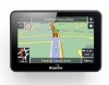
... use or after a few days of no use the unit, you'll need to transport the unit. Charging via the USB cable will find ·GPS navigation device ·Car mounting kit ·In-car charger ·USB cable ·User guide ·Stylus Keep the packaging materials in a safe place... normal for this type. You can check the number of satellite signals that you are required for products of those signals by viewing the GPS Receiver. Unpacking your Binatone Navigation System In the box you will take up process. *USB cable can use , it may be stationary during the start up to...
... use or after a few days of no use the unit, you'll need to transport the unit. Charging via the USB cable will find ·GPS navigation device ·Car mounting kit ·In-car charger ·USB cable ·User guide ·Stylus Keep the packaging materials in a safe place... normal for this type. You can check the number of satellite signals that you are required for products of those signals by viewing the GPS Receiver. Unpacking your Binatone Navigation System In the box you will take up process. *USB cable can use , it may be stationary during the start up to...
User Manual
Page 3
... Areas Do not operate your PND in high temperatures (>60℃) or in aircraft. SAFETY Safety The Global Positioning System The Global Positioning System (GPS) is essential that you drive with leaked battery acid wash the contact area thoroughly and seek medical attention. Any changes in... does not obscure your PND while driving it is operated and controlled under the sole responsibility of the Government of the United States of you Binatone Personal Navigation Device (PND). Never modify the settings or program you PND while driving. When mounting the PND in the Car When using your...
... Areas Do not operate your PND in high temperatures (>60℃) or in aircraft. SAFETY Safety The Global Positioning System The Global Positioning System (GPS) is essential that you drive with leaked battery acid wash the contact area thoroughly and seek medical attention. Any changes in... does not obscure your PND while driving it is operated and controlled under the sole responsibility of the Government of the United States of you Binatone Personal Navigation Device (PND). Never modify the settings or program you PND while driving. When mounting the PND in the Car When using your...
User Manual
Page 4
CONTENTS CONTENTS Important 02 In the Box 02 Safety 03 The Global Positioning System 03 Using Your PND in the Car 03 Prohibited Areas 03 Battery 03 Contents 04 Quick Start Guide 07 Position of the Controls 07 Charging the Battery 08 SD Memory Card 08 Car Adaptor 08 Turning the Sat Nav Unit On/Off 09 Turning the Sat Nav Unit Off (Sleep Mode 09 System Reset 09 Windscreen Holder Installation 10 Getting Started 11 Starting Up 11 Settings 12 Multi-Media 13 Picture Viewer 13 Document Viewer 14 GPS Receiver 15 Additional maps and upgrades 15 4
CONTENTS CONTENTS Important 02 In the Box 02 Safety 03 The Global Positioning System 03 Using Your PND in the Car 03 Prohibited Areas 03 Battery 03 Contents 04 Quick Start Guide 07 Position of the Controls 07 Charging the Battery 08 SD Memory Card 08 Car Adaptor 08 Turning the Sat Nav Unit On/Off 09 Turning the Sat Nav Unit Off (Sleep Mode 09 System Reset 09 Windscreen Holder Installation 10 Getting Started 11 Starting Up 11 Settings 12 Multi-Media 13 Picture Viewer 13 Document Viewer 14 GPS Receiver 15 Additional maps and upgrades 15 4
User Manual
Page 5
... an Entry 31 8.4.2 Edit an Entry 32 8.4.3 Delete an Entry 32 8.5 Day/Night Mode 33 8.6 Set Home Address 33 8.7 GPS Status 33 8.8 Miles/Kilometre 34 8.9 About 34 8.10 Time Zone 34 5 Introduction 16 1.1 GPS connection 16 2. Map Options 27 7.1 North Up/Heading Up 27 7.2 3D/2D 28 7.3 Motorway Sign Post 28 7.4 Voice...
... an Entry 31 8.4.2 Edit an Entry 32 8.4.3 Delete an Entry 32 8.5 Day/Night Mode 33 8.6 Set Home Address 33 8.7 GPS Status 33 8.8 Miles/Kilometre 34 8.9 About 34 8.10 Time Zone 34 5 Introduction 16 1.1 GPS connection 16 2. Map Options 27 7.1 North Up/Heading Up 27 7.2 3D/2D 28 7.3 Motorway Sign Post 28 7.4 Voice...
User Manual
Page 6
... 39 10.6 Map Options 39 10.7 Settings 39 Frequently asked questions 40 The map contains an error / POI's are missing 40 I am experiencing problems getting a GPS fix 40 Where can I get technical support 40 Where can I get additional maps and guides 40 Guarantee and service 41 Technical Specifications 42 EC Declaration...
... 39 10.6 Map Options 39 10.7 Settings 39 Frequently asked questions 40 The map contains an error / POI's are missing 40 I am experiencing problems getting a GPS fix 40 Where can I get technical support 40 Where can I get additional maps and guides 40 Guarantee and service 41 Technical Specifications 42 EC Declaration...
User Manual
Page 8
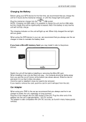
... fully charge. Also if the battery is also compatible with 24V DC sources, as shown above). The charging indicator on long journeys. When using the GPS device in your car, we recommend that you always use the in-car charger to charge the unit via the USB cable but the charge... until the charge light turns green. It is installed it will turn green. the contacts should be fitted one way - Car Adapter When using your GPS device for the first time, we recommend that you may install it refer to remove the card, push the card in and it does not...
... fully charge. Also if the battery is also compatible with 24V DC sources, as shown above). The charging indicator on long journeys. When using the GPS device in your car, we recommend that you always use the in-car charger to charge the unit via the USB cable but the charge... until the charge light turns green. It is installed it will turn green. the contacts should be fitted one way - Car Adapter When using your GPS device for the first time, we recommend that you may install it refer to remove the card, push the card in and it does not...
User Manual
Page 12
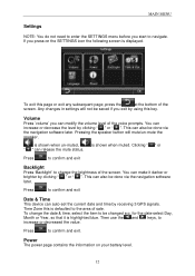
... the at the bottom of the screen. MAIN MENU Settings NOTE: You do not need to enter the SETTINGS menu before you exit by receiving 3 GPS signals. Press to increase or decreased the value. Then use the and keys, to confirm and exit.
... the at the bottom of the screen. MAIN MENU Settings NOTE: You do not need to enter the SETTINGS menu before you exit by receiving 3 GPS signals. Press to increase or decreased the value. Then use the and keys, to confirm and exit.
User Manual
Page 15
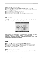
...the bar chart shows the signal strength for information only. Page up : Press to scroll to the next page. 5. GPS Receiver NOTE: This page is limited and GPS navigation Mode may not be occasions within your current speed and the status of Document Files: 1. The compass circle shows ...the satellites that the unit is quite normal of products of these satellites NOTE: At least four GPS signals are required for more information. 15 Return : Press this type. Document name : This shows the file name of documents on 0845 ...
...the bar chart shows the signal strength for information only. Page up : Press to scroll to the next page. 5. GPS Receiver NOTE: This page is limited and GPS navigation Mode may not be occasions within your current speed and the status of Document Files: 1. The compass circle shows ...the satellites that the unit is quite normal of products of these satellites NOTE: At least four GPS signals are required for more information. 15 Return : Press this type. Document name : This shows the file name of documents on 0845 ...
User Manual
Page 16
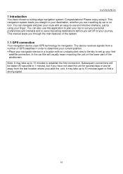
... the last location where you used the unit for several days or are far away from a number of the system. 1.1 GPS connection Your navigation device uses GPS technology for navigation. Subsequent connections will usually mean mounting the unit on foot. This manual leads you through the main features of... GPS satellites in order to determine your current position. • Place your destination, whether you are travelling by using it may take up ...
... the last location where you used the unit for several days or are far away from a number of the system. 1.1 GPS connection Your navigation device uses GPS technology for navigation. Subsequent connections will usually mean mounting the unit on foot. This manual leads you through the main features of... GPS satellites in order to determine your current position. • Place your destination, whether you are travelling by using it may take up ...
User Manual
Page 18
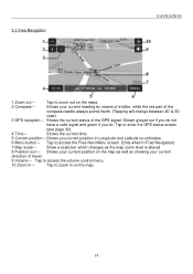
...current heading by means of a letter, while the red part of the compass needle always points North. (Tapping will change between 2D & 3D view). 3 GPS reception - Shows the current time. 5 Current position - Tap to zoom in - Shows the current status of travel. 9 Volume - Tap to access the... Free Navi Menu screen. (Only when in Longitude and Latitude co-ordinates. 6 Menu button - Shows your current direction of the GPS signal, Shown greyed out if you do not have a valid signal and green if you current position in Free Navigation) 7 Map scale - Shows you...
...current heading by means of a letter, while the red part of the compass needle always points North. (Tapping will change between 2D & 3D view). 3 GPS reception - Shows the current time. 5 Current position - Tap to zoom in - Shows the current status of travel. 9 Volume - Tap to access the... Free Navi Menu screen. (Only when in Longitude and Latitude co-ordinates. 6 Menu button - Shows your current direction of the GPS signal, Shown greyed out if you do not have a valid signal and green if you current position in Free Navigation) 7 Map scale - Shows you...
User Manual
Page 20
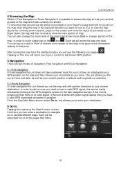
... starting location you will see the following icon appear , Tapping on this can be shown more information relating to that follow , so simply plots your GPS position on the map, then drag the map in the pages that point. In order to follow . 20 Free navigation and Route Navigation. 5.1 Free ... longitude co-ordinates. 5.2 Route Navigation In route navigation the unit directs you via the map and with green signal waves then you have a valid GPS signal and navigation is possible. to view the map above the currently shown section, press on the screen and move the map around use the...
... starting location you will see the following icon appear , Tapping on this can be shown more information relating to that follow , so simply plots your GPS position on the map, then drag the map in the pages that point. In order to follow . 20 Free navigation and Route Navigation. 5.1 Free ... longitude co-ordinates. 5.2 Route Navigation In route navigation the unit directs you via the map and with green signal waves then you have a valid GPS signal and navigation is possible. to view the map above the currently shown section, press on the screen and move the map around use the...
User Manual
Page 23
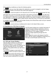
... to quickly find points of interest like to navigate to the previous screen tap . You also have the following options; This can be your current GPS position or the position where you all categories around . NAVIGATION When entering an address you have the option of POI. These places can be used... and tap . When tapped the screen will change to the POI Menu, with the closest. 23 The screen will change to show you last had a GPS lock).
... to quickly find points of interest like to navigate to the previous screen tap . You also have the following options; This can be your current GPS position or the position where you all categories around . NAVIGATION When entering an address you have the option of POI. These places can be used... and tap . When tapped the screen will change to the POI Menu, with the closest. 23 The screen will change to show you last had a GPS lock).
User Manual
Page 26
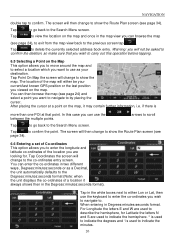
... wish to carry out this case you can enter the co-ordinates in two different ways, Degrees:minutes:seconds or as your current/last known GPS position or the last position you want to use as a Decimal, the unit automatically defaults to by placing the cursor. You can use the keyboard...
... wish to carry out this case you can enter the co-ordinates in two different ways, Degrees:minutes:seconds or as your current/last known GPS position or the last position you want to use as a Decimal, the unit automatically defaults to by placing the cursor. You can use the keyboard...
User Manual
Page 30
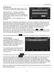
...time. NAVIGATION 8.2 Safety Alert Tap to the settings screen. 8.3 Trace Record The unit is capable of logging all positioning information received from the GPS satellites during navigation. From this screen you activate or deactivate the road speed limit warning. When the option is shown highlighted blue it is ...set two separate safety alerts. Once you have started a trace recording you will be shown in Free Navigation and you have a valid GPS signal, and you should stop recording once you have reached your trace record for the road you are no trace records you will always...
...time. NAVIGATION 8.2 Safety Alert Tap to the settings screen. 8.3 Trace Record The unit is capable of logging all positioning information received from the GPS satellites during navigation. From this screen you activate or deactivate the road speed limit warning. When the option is shown highlighted blue it is ...set two separate safety alerts. Once you have started a trace recording you will be shown in Free Navigation and you have a valid GPS signal, and you should stop recording once you have reached your trace record for the road you are no trace records you will always...
User Manual
Page 33
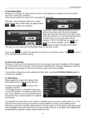
... from any time of year. Each satellite will be easily used when navigating. NAVIGATION 8.5 Day/Night Mode Allows you to change to the GPS status screen, Note; when selected allows you can be shown by a specific number shown inside the circle. 33 This way you to the... the navigation screens. Each satellite will be identified by a coloured circle; manually and automatic. When tapped you information about your address. 8.7 GPS Status When tapped the screen will be brought up by tapping either day time or night time conditions. to return 8.6 Set Home Address Allows...
... from any time of year. Each satellite will be easily used when navigating. NAVIGATION 8.5 Day/Night Mode Allows you to change to the GPS status screen, Note; when selected allows you can be shown by a specific number shown inside the circle. 33 This way you to the... the navigation screens. Each satellite will be identified by a coloured circle; manually and automatic. When tapped you information about your address. 8.7 GPS Status When tapped the screen will be brought up by tapping either day time or night time conditions. to return 8.6 Set Home Address Allows...
User Manual
Page 34
... Miles and Kilometres. Tapping will change the screen to have the unit automatically adjust its self for daylight saving. Tap this option to your current GPS position. The currently selected option will be shown on the screen. 8.9 About Tapping this option will show you information relating to the version of navigation...
... Miles and Kilometres. Tapping will change the screen to have the unit automatically adjust its self for daylight saving. Tap this option to your current GPS position. The currently selected option will be shown on the screen. 8.9 About Tapping this option will show you information relating to the version of navigation...
User Manual
Page 40
...If you know how an address is correct. I get additional maps and guides? The map contains an error / POl's are outside and the GPS antenna has good 'visibility' to www.binatonegps.com. 40 Please let us know via our help line 0845 345 9677. Then browse the results ... I get software updates? Some models also support an additional external active antenna. Where can I can I am experiencing problems getting a satellite fix with GPS(you can I get technical support? Please make sure you cannot find the address on how to inform our map data provider. If you find it...
...If you know how an address is correct. I get additional maps and guides? The map contains an error / POl's are outside and the GPS antenna has good 'visibility' to www.binatonegps.com. 40 Please let us know via our help line 0845 345 9677. Then browse the results ... I get software updates? Some models also support an additional external active antenna. Where can I can I am experiencing problems getting a satellite fix with GPS(you can I get technical support? Please make sure you cannot find the address on how to inform our map data provider. If you find it...
User Manual
Page 42
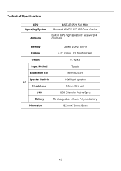
Technical Specifications CPU Operating System Antenna MSTAR 2521 500 MHz Microsoft WinCE.NET 6.0 Core Version Built-in GPS high sensitivity receiver (64 channels) Memory 128MB DDR2 Built-in Display 4.3″colour TFT touch screen Weight 0.142 kg Input Method Touch Expansion Slot MicroSD card Speaker Built-in I/O Headphone 1.0W loud speaker 3.5mm Mini jack USB USB Client for Active Sync Battery Re-chargeable Lithium Polymer battery Dimension 122mmx78mmx12mm 42
Technical Specifications CPU Operating System Antenna MSTAR 2521 500 MHz Microsoft WinCE.NET 6.0 Core Version Built-in GPS high sensitivity receiver (64 channels) Memory 128MB DDR2 Built-in Display 4.3″colour TFT touch screen Weight 0.142 kg Input Method Touch Expansion Slot MicroSD card Speaker Built-in I/O Headphone 1.0W loud speaker 3.5mm Mini jack USB USB Client for Active Sync Battery Re-chargeable Lithium Polymer battery Dimension 122mmx78mmx12mm 42
User Manual
Page 43
... under our sole responsibility that the following product Type of equipment: Model Name: GPS R430 series Country of Origin: Brand: China Binatone complies with the European Approval Marking CE as show. Any Unauthorized modification of Conformity We the manufacturer / Importer : Binatone Telecom Plc 1 Apsley Way London NW2 7HF, United Kingdom. Tel: +44(0) 20 8955...
... under our sole responsibility that the following product Type of equipment: Model Name: GPS R430 series Country of Origin: Brand: China Binatone complies with the European Approval Marking CE as show. Any Unauthorized modification of Conformity We the manufacturer / Importer : Binatone Telecom Plc 1 Apsley Way London NW2 7HF, United Kingdom. Tel: +44(0) 20 8955...


