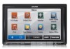
Navigation User's Manual (english)
Page 1
User Manual Alpine Navigation Navigation software for the Alpine INE-S920HD/INE-Z928HD/INE-NAV-30/INE-NAV-38 US English (EN)
Navigation User's Manual (english)
Page 2
You can easily discover the software while you read this manual to fully understand the screens and features. 2 however, we still recommend that you are using your navigator. This document is the detailed description of the navigation software. Start using it; Thank you for choosing the Alpine unit as your device right away.
Navigation User's Manual (english)
Page 3
... ...7 2.1 Buttons and other controls on the screen 8 2.1.1 Using keyboards...9 2.1.2 Beyond single screen tap...10 2.2 Map screen...11 2.2.1 Navigating on the map ...11 2.2.2 Position markers...14 2.2.2.1 Vehimarker and Lock-on-Road...14 2.2.2.2 Selected map location (Cursor) and selected map object ... Traffic events ...18 2.2.4 Manipulating the map ...19 2.2.5 Checking the details of the current position (Where Am I 21 2.3 Navigation menu ...22 3 On-road navigation ...23 3.1 Selecting the destination of a route 23 3.1.1 Entering an address or a part of the address 23 3.1.1.1 Entering ...
Navigation User's Manual (english)
Page 4
...Address Book 50 3.1.6 Selecting a recent destination from the History 51 3.1.7 Entering the coordinate of the destination 52 3.1.8 Navigate to a location stored in a picture 53 3.1.9 Building a route from the list of destinations (Create Route 54 ...Navigating in off-road mode ...63 5 Reference Guide ...64 5.1 Concepts ...64 5.1.1 Smart Zoom ...64 5.1.2 Route calculation and recalculation ...64 5.1.3 Green routing ...66 5.1.4 Speed limit warning ...67 5.1.5 Traffic information in route planning ...67 5.1.5.1 Historical traffic...67 5.1.5.2 Real-time traffic information (TMC) (INE-Z928HD/INE...
Navigation User's Manual (english)
Page 6
... your software before your software changes the instructions accordingly. 6 You must obey the traffic signs and follow the road geometry. 1 Warnings and Safety information The navigation system helps you find your way to do so. others cannot track you.
Navigation User's Manual (english)
Page 7
... for the first time, an initial setup process starts automatically. Later you can change it in Regional settings (page 81). 2. 2 Getting started When using the navigation software for voice guidance messages. Later you can change it in Regional settings (page 81). 7 Select the written language of the application interface. Do as...
Navigation User's Manual (english)
Page 11
...other side of the screen. Tap to reduce the map size to half and allow information from your Alpine unit audio system to get the valid GPS position. 11 You can decide which side of the ...and the surrounding map area. When there is no GPS position, the Vehimarker is the navigation. The application starts with a full screen map. Simply tap the audio part and drag it in the desired... direction. 2.2 Map screen 2.2.1 Navigating on keyboard screens: you can delete several characters quickly. • Tap and hold on the...
Navigation User's Manual (english)
Page 12
...remaining segments of the route. Tap the button below the data fields to change its value): Field Description Shows the distance you navigate. Historical traffic data can also be taken into account traffic delays affecting your current position. Two data fields are no specified destination..., this calculation is displayed in full color, now showing your route if they are three map view modes. Default data fields when navigating a route (tap any of receiving live traffic information, the calculation takes into account if data is not displayed). When GPS position ...
Navigation User's Manual (english)
Page 14
... heading. 2.2.2.2 Selected map location (Cursor) and selected map object You can mark a map location in the following ways: • Tap the map when navigating, • Tap the map when you tap the map at the icon of a Place of a search, or • Tap the map in Find ... freeway from a small street. 14 You can get information about this icon in a way that is similar to their importance: you select off-road navigation: The Vehimarker is at your exact GPS position and heading. 2.2.2 Position markers 2.2.2.1 Vehimarker and Lock-on-Road When your GPS position is available, the...
Navigation User's Manual (english)
Page 15
... the traffic circle, 3rd exit. Both the type of these icons are displayed. Continue straight in the top left . 2.2.3.2 Turn preview and Next street When navigating a route, the top section of the frequently shown route events. There is a field in the intersection. Enter freeway. Most of the event (turn, traffic circle...
Navigation User's Manual (english)
Page 16
... and the number of them and the normal Map screen returns until new signpost information is displayed in order to take . When navigating a route, only the signpost that points to the lane(s) to . If lane information is replaced with updated distance information. •...; Tap the Next street field to open the Itinerary. 2.2.3.3 Lane information and Signposts When navigating on multilane roads, it is available. Approaching a waypoint. Where additional information is no recommended route). all others are displayed at the top...
Navigation User's Manual (english)
Page 17
Tap this button to plot the route map in 3D when you navigate. Hills and mountains are shown in the background of the 3D map, and illustrated by color and shading on the map and add it as ...
Navigation User's Manual (english)
Page 18
... starts from the route color. Normally if GPS position is aligned to the nearest road. Route color Streets and roads that are excluded from the navigation Streets and roads that is no valid GPS position, your software cannot avoid such roads, the route will include them in a color that are near...
Navigation User's Manual (english)
Page 19
... of the list items to see the number of traffic events on the map: 2.2.4 Manipulating the map Tap the map anywhere to browse it during navigation. In the first column you can move the map in any direction: tap and hold the map, and move the map. 19 The second column...
Navigation User's Manual (english)
Page 20
... zoom levels, always with optimized content. Changes the horizontal view angle of the map in 3D map view mode. The map manipulation buttons disappear and navigation continues. Zooming in and out , Tilting up and down , Rotating left and right Compass Location information Return to normal... navigation , , , Additional options Select destination Changes how much of the map is also re-enabled. Tap this button to move the map back to 2D view ...
Navigation User's Manual (english)
Page 21
...; Address details (when available) of the current position are also displayed at the bottom. You can access this screen: Tap Information. screen. • In the Navigation menu, tap Information on this screen: and then . • , : Latitude and Longitude (coordinate of the current position in WGS84 format). • : Altitude (elevation information coming...
Navigation User's Manual (english)
Page 22
...or one of your Address Book entries. You have taken or to run some additional applications.. • Tap to customize the way the navigation software works. • Press the MAP hardware button to start point for the route, picking route alternatives, avoiding parts of the route or ...simulating navigation. • Tap to get information about your current position, the GPS reception or the trips you open the menu, the destination search buttons...
Navigation User's Manual (english)
Page 23
...the center of a city/town • an intersection • the midpoint of a street 23 Then select a second destination and add it right away (normal navigation). • You can find an address or Place (page 48). • Select a location on the map with ZIP code (page 36). For details,... GPS receiver and set up your route in Place of the high quality vector maps provided with multiple destinations. 3 On-road navigation When first started, Alpine unit calculates routes using the road network of Interest as your route as many destinations to create a multi-point route. You ...
Navigation User's Manual (english)
Page 24
... the city/town from the list. Select a new city/town: a. For a local search, tap city/town name. c. Find the city/town you are. In the Navigation menu, tap the following buttons: , . 2. The city/town of the city/town on the keyboard, and select one from the list. 24 Start entering the...
Navigation User's Manual (english)
Page 26
In the Navigation menu, tap the following buttons: , . 2. By default, the software proposes the country, state and city/town where you can search for the new entry, and ...