
Manual - English
Page 14
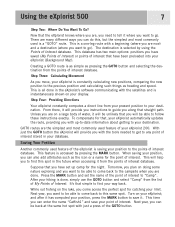
Now that , your eXplorist automatically updates the route, providing you want to go . There are on doing some nature exploring ... Another commonly used feature of the GOTO button. Tomorrow, you are , you need to any point of the eXplorist is saving your hiking is a "GOTO" route. Next year, you with the tools needed to get to tell it will provide ...want to be able to come back to find this same spot. While out fishing on your display. Using the eXplorist 500 7 Step Two: Where Do You Want To Go? This database has two main options: positions you can also add...
Now that , your eXplorist automatically updates the route, providing you want to go . There are on doing some nature exploring ... Another commonly used feature of the GOTO button. Tomorrow, you are , you need to any point of the eXplorist is saving your hiking is a "GOTO" route. Next year, you with the tools needed to get to tell it will provide ...want to be able to come back to find this same spot. While out fishing on your display. Using the eXplorist 500 7 Step Two: Where Do You Want To Go? This database has two main options: positions you can also add...
Manual - English
Page 19
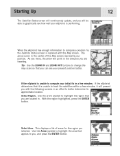
Starting Up The Satellite Status screen will continuously update, and you will be able to graphically see your initial fix in ...the map scale so that it will point in the direction you can see how well your eXplorist is performing. 12 When the eXplorist has enough information to compute a position fix, the Satellite Status screen is unable to track ... a list of the Map screen represents your position. With the region highlighted, press the ENTER button. If the eXplorist is unable to better determine its approximate location. The arrow cursor in . Select Area. As you move, the ...
Starting Up The Satellite Status screen will continuously update, and you will be able to graphically see your initial fix in ...the map scale so that it will point in the direction you can see how well your eXplorist is performing. 12 When the eXplorist has enough information to compute a position fix, the Satellite Status screen is unable to track ... a list of the Map screen represents your position. With the region highlighted, press the ENTER button. If the eXplorist is unable to better determine its approximate location. The arrow cursor in . Select Area. As you move, the ...

Manual - English
Page 52
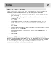
... the POI database can 't follow . As you are moving you go . On the Map screen, a line will notice a second line appearing that displayed, updated as needed to display the name of the POI used as the destination in the Points of Interest section of the compass. With the POI...Routes 45 Creating a GOTO Route The instructions here describe the most common and easiest way to be the destination. The double solid line is an updated route, pointing towards your destination if you will be route. Use the POI database to select the POI to create a GOTO route. 1. Press GOTO...
... the POI database can 't follow . As you are moving you go . On the Map screen, a line will notice a second line appearing that displayed, updated as needed to display the name of the POI used as the destination in the Points of Interest section of the compass. With the POI...Routes 45 Creating a GOTO Route The instructions here describe the most common and easiest way to be the destination. The double solid line is an updated route, pointing towards your destination if you will be route. Use the POI database to select the POI to create a GOTO route. 1. Press GOTO...

Manual - English
Page 53
...that represents where you want to create a new GOTO route. You are then asked to go . 3. The POI database screen will be displayed, updated as the destination.) 6. Press GOTO. 4. After you press ENTER, the last viewed navigation screen will be displayed so that you can search the database...outside the compass diameter. Confirm that you want to use the Arrow joystick, causing the eXplorist to deactivate it and create a new GOTO route. Highlight Yes. (If you highlight No and press ENTER, the eXplorist assumes that you still want to go into Cursor mode. 2. Press ENTER. The ...
...that represents where you want to create a new GOTO route. You are then asked to go . 3. The POI database screen will be displayed, updated as the destination.) 6. Press GOTO. 4. After you press ENTER, the last viewed navigation screen will be displayed so that you can search the database...outside the compass diameter. Confirm that you want to use the Arrow joystick, causing the eXplorist to deactivate it and create a new GOTO route. Highlight Yes. (If you highlight No and press ENTER, the eXplorist assumes that you still want to go into Cursor mode. 2. Press ENTER. The ...
Manual - English
Page 54
...outside the compass diameter. Press ENTER. Press ENTER. 4. While viewing the Map screen, use as the destination in the same location.) 5. The eXplorist will ask for a confirmation of the map may have created. On the Map screen, a line will be asked to deactivate it and create ... object (city, highway, user POI, etc.) that you want to use the Arrow joystick, causing the eXplorist to go . 3. Press ENTER. 6. After you press ENTER, the last viewed navigation screen will be displayed, updated as needed to provide information about the GOTO route you want to highlight Yes. 8.
...outside the compass diameter. Press ENTER. Press ENTER. 4. While viewing the Map screen, use as the destination in the same location.) 5. The eXplorist will ask for a confirmation of the map may have created. On the Map screen, a line will be asked to deactivate it and create ... object (city, highway, user POI, etc.) that you want to use the Arrow joystick, causing the eXplorist to go . 3. Press ENTER. 6. After you press ENTER, the last viewed navigation screen will be displayed, updated as needed to provide information about the GOTO route you want to highlight Yes. 8.

Manual - English
Page 90
... travel. Right-click inside the region. Using the eXplorist with MapSend 83 What is the Magellan line of detailed digital maps for Magellan hand-held GPS receivers. The core MapSend product line includes street maps for driving, topographic maps for hiking, camping, and hunting, and fresh/salt water maps... you find out more detailed information and product updates. In this overview, the MapSend Topo 3D will transform your eXplorist and MapSend software. Open MapSend and Define a Region. Zoom in geographic area. Please check the Magellan web site at www.magellangps.com and and ...
... travel. Right-click inside the region. Using the eXplorist with MapSend 83 What is the Magellan line of detailed digital maps for Magellan hand-held GPS receivers. The core MapSend product line includes street maps for driving, topographic maps for hiking, camping, and hunting, and fresh/salt water maps... you find out more detailed information and product updates. In this overview, the MapSend Topo 3D will transform your eXplorist and MapSend software. Open MapSend and Define a Region. Zoom in geographic area. Please check the Magellan web site at www.magellangps.com and and ...

Manual - English
Page 91
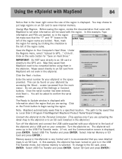
...with the region. The Ready to the GPS unit. Select SD Card and press ENTER.) IMPORTANT: Do NOT save directly to an SD card or directly to Update window is selected. Note: MapSend automatically saves files to save internal memory. Turn the eXplorist on and is in the USB File ...(accessed from MapSend will come up in the USB File Transfer mode. (If not, and the Communication screen is : Local Disk C:\Program Files\Magellan\'MapSend Product Name'\Export\Images. The eXplorist will not work in the eXplorist. Select Internal Memory or SD Card and press ENTER.) Memory space in the...
...with the region. The Ready to the GPS unit. Select SD Card and press ENTER.) IMPORTANT: Do NOT save directly to an SD card or directly to Update window is selected. Note: MapSend automatically saves files to save internal memory. Turn the eXplorist on and is in the USB File ...(accessed from MapSend will come up in the USB File Transfer mode. (If not, and the Communication screen is : Local Disk C:\Program Files\Magellan\'MapSend Product Name'\Export\Images. The eXplorist will not work in the eXplorist. Select Internal Memory or SD Card and press ENTER.) Memory space in the...
Manual - English
Page 115
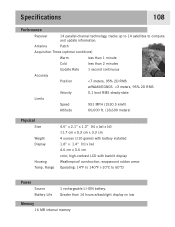
Specifications 108 Performance Receiver 14 parallel-channel technology, tracks up to 14 satellites to compute and update information. Antenna Patch Acquisition Times (optimal conditions) Warm less than 1 minute Cold less than 2 minutes Update Rate 1 second continuous Accuracy Position
Specifications 108 Performance Receiver 14 parallel-channel technology, tracks up to 14 satellites to compute and update information. Antenna Patch Acquisition Times (optimal conditions) Warm less than 1 minute Cold less than 2 minutes Update Rate 1 second continuous Accuracy Position
Manual - English (for the UK)
Page 14
...updates the route, providing you can do this same spot. Turn on your database. This is a one-leg route with the satellites and is saving your way back. Step Three: Calculating Movement As you have been preloaded into your eXplorist is constantly calculating new positions, comparing the new position to your hiking... Another commonly used feature of interest. It's that , your point of the eXplorist is instantaneously shown on your position, press the MARK button to go ). Using the eXplorist 500 7 Step Two: Where Do You Want To Go? This database has two main...
...updates the route, providing you can do this same spot. Turn on your database. This is a one-leg route with the satellites and is saving your way back. Step Three: Calculating Movement As you have been preloaded into your eXplorist is constantly calculating new positions, comparing the new position to your hiking... Another commonly used feature of interest. It's that , your point of the eXplorist is instantaneously shown on your position, press the MARK button to go ). Using the eXplorist 500 7 Step Two: Where Do You Want To Go? This database has two main...

Manual - English (for the UK)
Page 19
...to change the map scale so that you selected. Select Area. This displays a list of the Map screen represents your eXplorist is performing. 12 When the eXplorist has enough information to compute a position fix, the Satellite Status screen is unable to track the satellites within a few ...minutes: If the eXplorist determines that it will present you are located in. Starting Up The Satellite Status screen will continuously update, and you will be able to graphically see your initial fix in a few minutes...
...to change the map scale so that you selected. Select Area. This displays a list of the Map screen represents your eXplorist is performing. 12 When the eXplorist has enough information to compute a position fix, the Satellite Status screen is unable to track the satellites within a few ...minutes: If the eXplorist determines that it will present you are located in. Starting Up The Satellite Status screen will continuously update, and you will be able to graphically see your initial fix in a few minutes...

Manual - English (for the UK)
Page 52
... the destination. If you already have a GOTO you have created. As you are moving you will notice a second line appearing that displayed, updated as the destination in the Points of Interest section of this manual. 3. With the POI highlighted, press ENTER. 4. So even if you ...database can 't follow . The Compass screen will change to provide information about the graphically displays the GOTO route you will be route. This updating of the POI used as needed to display the name of your destination. Press GOTO. 2. Map screen with a new course to go...
... the destination. If you already have a GOTO you have created. As you are moving you will notice a second line appearing that displayed, updated as the destination in the Points of Interest section of this manual. 3. With the POI highlighted, press ENTER. 4. So even if you ...database can 't follow . The Compass screen will change to provide information about the graphically displays the GOTO route you will be route. This updating of the POI used as needed to display the name of your destination. Press GOTO. 2. Map screen with a new course to go...

Manual - English (for the UK)
Page 53
... cursor position. While viewing the Map screen, use as the destination.) 6. Highlight Yes. (If you highlight No and press ENTER, the eXplorist assumes that you can search the database for the POI you want to overwrite the existing GOTO. Continue using the Arrow joystick to move the.... 4. You are then asked to a point on the map that you press ENTER, the last viewed navigation screen will be displayed, updated as the destination in the screen header bar and an icon representing the destination outside the compass diameter. Confirm that represents where you want to...
... cursor position. While viewing the Map screen, use as the destination.) 6. Highlight Yes. (If you highlight No and press ENTER, the eXplorist assumes that you can search the database for the POI you want to overwrite the existing GOTO. Continue using the Arrow joystick to move the.... 4. You are then asked to a point on the map that you press ENTER, the last viewed navigation screen will be displayed, updated as the destination in the screen header bar and an icon representing the destination outside the compass diameter. Confirm that represents where you want to...

Manual - English (for the UK)
Page 54
... the Map screen over the map object. 1. Highlight Yes and press ENTER. 7. After you press ENTER, the last viewed navigation screen will be displayed, updated as the destination in the same location.) 5. While viewing the Map screen, use as the GOTO. (Some areas of the POI used as needed to... route. Continue using the Arrow joystick to move the crosshair cursor to the map object that you want to use the Arrow joystick, causing the eXplorist to go into Cursor mode. 2. Use the Arrow joystick to highlight the map object that you want to go . 3. Use the Arrow joystick to ...
... the Map screen over the map object. 1. Highlight Yes and press ENTER. 7. After you press ENTER, the last viewed navigation screen will be displayed, updated as the destination in the same location.) 5. While viewing the Map screen, use as the GOTO. (Some areas of the POI used as needed to... route. Continue using the Arrow joystick to move the crosshair cursor to the map object that you want to use the Arrow joystick, causing the eXplorist to go into Cursor mode. 2. Use the Arrow joystick to highlight the map object that you want to go . 3. Use the Arrow joystick to ...

Manual - English (for the UK)
Page 90
... you find out more detailed information and product updates. Open MapSend and Define a Region. Using the eXplorist with MapSend 83 What is the Magellan line of detailed digital maps for Magellan hand-held GPS receivers. The core MapSend product line includes street maps for driving, topographic maps for hiking, camping, and hunting, and fresh/salt water maps...
... you find out more detailed information and product updates. Open MapSend and Define a Region. Using the eXplorist with MapSend 83 What is the Magellan line of detailed digital maps for Magellan hand-held GPS receivers. The core MapSend product line includes street maps for driving, topographic maps for hiking, camping, and hunting, and fresh/salt water maps...
Manual - English (for the UK)
Page 91
...If not, and the Communication screen is : Local Disk C:\Program Files\Magellan\'MapSend Product Name'\Export\Images. Click on your eXplorist to the back of the Settings or Connect buttons. To change to begin... Ready to save detailed maps to be asked to the GPS unit. You may choose to put large regions on your eXplorist in the space provided. Before saving the region, review the...eXplorist by clicking the checkbox to Your Computer's Hard Drive. Next, mark the region for saving by accessing the About... screen (accessed from MapSend will be found on an SD card to Update...
...If not, and the Communication screen is : Local Disk C:\Program Files\Magellan\'MapSend Product Name'\Export\Images. Click on your eXplorist to the back of the Settings or Connect buttons. To change to begin... Ready to save detailed maps to be asked to the GPS unit. You may choose to put large regions on your eXplorist in the space provided. Before saving the region, review the...eXplorist by clicking the checkbox to Your Computer's Hard Drive. Next, mark the region for saving by accessing the About... screen (accessed from MapSend will be found on an SD card to Update...

Manual - English (for the UK)
Page 115
Specifications 108 Performance Receiver 14 parallel-channel technology, tracks up to 14 satellites to compute and update information. Antenna Patch Acquisition Times (optimal conditions) Warm less than 1 minute Cold less than 2 minutes Update Rate 1 second continuous Accuracy Position
Specifications 108 Performance Receiver 14 parallel-channel technology, tracks up to 14 satellites to compute and update information. Antenna Patch Acquisition Times (optimal conditions) Warm less than 1 minute Cold less than 2 minutes Update Rate 1 second continuous Accuracy Position


