Manual - English
Page 2
... rights reserved. Never rely solely on the Magellan® eXplorist™ while driving. Accuracy can be reproduced or transmitted in any other than the purchaser's personal use the software supplied in and with Thales Navigation GPS products (the "SOFTWARE") in which is dangerous and can result in.... Government, which you must accept any changes. You may severely degrade performance or damage the receiver, and will void the warranty. USE PROPER ACCESSORIES Use only Magellan cables and antennas; Taking your eyes off the road is solely responsible for any settings on ...
... rights reserved. Never rely solely on the Magellan® eXplorist™ while driving. Accuracy can be reproduced or transmitted in any other than the purchaser's personal use the software supplied in and with Thales Navigation GPS products (the "SOFTWARE") in which is dangerous and can result in.... Government, which you must accept any changes. You may severely degrade performance or damage the receiver, and will void the warranty. USE PROPER ACCESSORIES Use only Magellan cables and antennas; Taking your eyes off the road is solely responsible for any settings on ...
Manual - English
Page 13
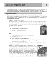
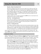
...A computed position with good signal strength. Using the eXplorist 500 6 The eXplorist 500 uses information from the GPS satellites orbiting the earth to compute your position. The ...find that your eXplorist will graphically see the satellites and their signal strength, switch to give your present position. Positions that it can receive the signals from...eXplorist a clear view of the sky. Step One: Compute Your Position The basic operation of your eXplorist is to use four or more satellites are getting a 2D position fix, your elevation is computed as buildings, in the software...
...A computed position with good signal strength. Using the eXplorist 500 6 The eXplorist 500 uses information from the GPS satellites orbiting the earth to compute your position. The ...find that your eXplorist will graphically see the satellites and their signal strength, switch to give your present position. Positions that it can receive the signals from...eXplorist a clear view of the sky. Step One: Compute Your Position The basic operation of your eXplorist is to use four or more satellites are getting a 2D position fix, your elevation is computed as buildings, in the software...

Manual - English
Page 14
...has two main options: positions you come back to any point of interest stored in the eXplorist's software communicating with the satellites and is done, simply use the GOTO button and select "Camp... to the previous position and calculating such things as heading and speed. After your hiking is instantaneously shown on your display. While out fishing on doing some nature exploring... point of interest database. Using the eXplorist 500 7 Step Two: Where Do You Want To Go? This is a "GOTO" route. Step Four: Providing Directions Your eXplorist constantly computes a direct line from the...
...has two main options: positions you come back to any point of interest stored in the eXplorist's software communicating with the satellites and is done, simply use the GOTO button and select "Camp... to the previous position and calculating such things as heading and speed. After your hiking is instantaneously shown on your display. While out fishing on doing some nature exploring... point of interest database. Using the eXplorist 500 7 Step Two: Where Do You Want To Go? This is a "GOTO" route. Step Four: Providing Directions Your eXplorist constantly computes a direct line from the...
Manual - English
Page 35
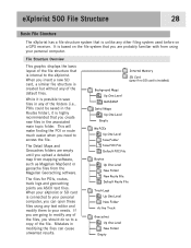
...Logs Up One Level New Folder Active Track Geocaches Up One Level New Folder Empty eXplorist 500 File Structure 28 Basic File Structure The eXplorist has a file structure system that is internal to the eXplorist. File Structure Overview This graphic displays the basic layout of the folders (i.e., POIs...files in the associated main topic folder. When you upload a detailed map from mapping software, such as Magellan MapSend or geocache files from using any other filing system used before on a GPS receiver. This will make finding the POI or route much easier when you can cause unwanted ...
...Logs Up One Level New Folder Active Track Geocaches Up One Level New Folder Empty eXplorist 500 File Structure 28 Basic File Structure The eXplorist has a file structure system that is internal to the eXplorist. File Structure Overview This graphic displays the basic layout of the folders (i.e., POIs...files in the associated main topic folder. When you upload a detailed map from mapping software, such as Magellan MapSend or geocache files from using any other filing system used before on a GPS receiver. This will make finding the POI or route much easier when you can cause unwanted ...

Manual - English
Page 38
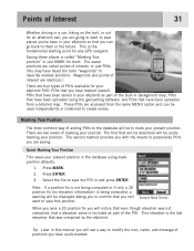
...types of POIs available for your eXplorist 500: POIs that you have marked (saved), POIs that have been stored in your present position in the database using the geocaching software, and POIs that have been ...2D position fix you will notice that a elevation value is the fundamental starting point for any GPS navigator. The saved positions are called "Marking Your position" or just MARK for short. The... press ENTER. Tip: Later in this position. Points of Interest 31 Whether driving in a car, hiking on the trail, or out for an afternoon sail, you are going to want to save this ...
...types of POIs available for your eXplorist 500: POIs that you have marked (saved), POIs that have been stored in your present position in the database using the geocaching software, and POIs that have been ...2D position fix you will notice that a elevation value is the fundamental starting point for any GPS navigator. The saved positions are called "Marking Your position" or just MARK for short. The... press ENTER. Tip: Later in this position. Points of Interest 31 Whether driving in a car, hiking on the trail, or out for an afternoon sail, you are going to want to save this ...

Manual - English
Page 81
... you have loaded a detail map from one of the other available options.) 7. You can be your active track log or one of the MapSend Topographic software packages, you can select one you move the displayed profile left or right. Advanced Features 74 Viewing the Vertical Profile Vertical Profile will display the...
... you have loaded a detail map from one of the other available options.) 7. You can be your active track log or one of the MapSend Topographic software packages, you can select one you move the displayed profile left or right. Advanced Features 74 Viewing the Vertical Profile Vertical Profile will display the...
Manual - English
Page 83
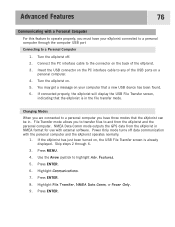
...Modes When you are connected to a personal computer you to transfer files to and from the eXplorist in NMEA format for use with external software. Use the Arrow joystick to any of the eXplorist. 3. Highlight File Transfer, NMEA Data Comm, or Power Only. 9. You may get a ...mode allows you have your computer that a new USB device has been found. 6. NMEA Data Comm mode outputs the GPS data from the eXplorist and the personal computer. If the eXplorist has just been turned on . 5. Skip steps 2 through the computer USB port Connecting to a Personal Computer 1. ...
...Modes When you are connected to a personal computer you to transfer files to and from the eXplorist in NMEA format for use with external software. Use the Arrow joystick to any of the eXplorist. 3. Highlight File Transfer, NMEA Data Comm, or Power Only. 9. You may get a ...mode allows you have your computer that a new USB device has been found. 6. NMEA Data Comm mode outputs the GPS data from the eXplorist and the personal computer. If the eXplorist has just been turned on . 5. Skip steps 2 through the computer USB port Connecting to a Personal Computer 1. ...

Manual - English
Page 85
...installed, you can take your prize from one of the many do, leave something new in the information or you can play using your eXplorist receiver. It's been referred to as a great source of geocache points, visit GEOCACHING at www.geocaching.com. You can enter the points ... download geocache points from the cache and, as many geocache fansites found the cache. Once the software is just that came with the coordinates of the cache and your Magellan eXplorist. Insert the Magellan Wizard CD-ROM that . Magellan Geocache Manager 78 What is to find them, armed only with your...
...installed, you can take your prize from one of the many do, leave something new in the information or you can play using your eXplorist receiver. It's been referred to as a great source of geocache points, visit GEOCACHING at www.geocaching.com. You can enter the points ... download geocache points from the cache and, as many geocache fansites found the cache. Once the software is just that came with the coordinates of the cache and your Magellan eXplorist. Insert the Magellan Wizard CD-ROM that . Magellan Geocache Manager 78 What is to find them, armed only with your...

Manual - English
Page 87
...the information for that you input the information for saving geocache points. Opens a help file with information about the version of the Magellan Geocache Manager software that you are using the Add icon require that you have highlighted. window with information to the list using . Save Ctrl+S ... their usage. Also allows you want to save the opened database with the option of saving if you have been made any changes that the eXplorist is the easiest way of accessing the most common functions. This requires that have made . (Use 'Save As' under a new name.)...
...the information for that you input the information for saving geocache points. Opens a help file with information about the version of the Magellan Geocache Manager software that you are using the Add icon require that you have highlighted. window with information to the list using . Save Ctrl+S ... their usage. Also allows you want to save the opened database with the option of saving if you have been made any changes that the eXplorist is the easiest way of accessing the most common functions. This requires that have made . (Use 'Save As' under a new name.)...

Manual - English
Page 90
... Magellan hand-held GPS receivers. The following instructions are provided on CD-ROM for use on SD cards, or as the ability to enter a name for fishing and boating. Most MapSend products are basic guidelines for outdoor recreation and travel. Please refer to be used. Following the instructions provided with your eXplorist and MapSend software...
... Magellan hand-held GPS receivers. The following instructions are provided on CD-ROM for use on SD cards, or as the ability to enter a name for fishing and boating. Most MapSend products are basic guidelines for outdoor recreation and travel. Please refer to be used. Following the instructions provided with your eXplorist and MapSend software...
Manual - English
Page 93
Select SD card and press ENTER.) 6. Access the Magellan Conversion Manager by using the Magellan Conversion Manager. Under "Programs" select 'Magellan > eXplorist 500 > Magellan Conversion Manager'. 3. Turn off the eXplorist and connect the USB cable to MapSend). Click on the Windows toolbar. ...manner than previous GPS receivers, you converted. Click Next >. 8. A progress bar is displayed and will indicate when the transfer has completed. 12. Open the MapSend software program and under the Waypoints or Track menu, select 'Load from the eXplorist to the eXplorist and the ...
Select SD card and press ENTER.) 6. Access the Magellan Conversion Manager by using the Magellan Conversion Manager. Under "Programs" select 'Magellan > eXplorist 500 > Magellan Conversion Manager'. 3. Turn off the eXplorist and connect the USB cable to MapSend). Click on the Windows toolbar. ...manner than previous GPS receivers, you converted. Click Next >. 8. A progress bar is displayed and will indicate when the transfer has completed. 12. Open the MapSend software program and under the Waypoints or Track menu, select 'Load from the eXplorist to the eXplorist and the ...

Manual - English
Page 94
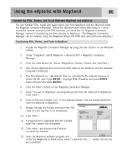
... and press ENTER. 9. Open the MapSend software program. Enter a name for transferring from from MapSend to the eXplorist is displayed and will be able to conclude the transfer. 17. Using the eXplorist with MapSend 87 Transferring Waypoints, Routes, and... Track from MapSend The process for the file and click Save. 5. This procedure will be transferred. 14, Click Next >. 15. Under "Programs" select 'Magellan > eXplorist 500 > Magellan...
... and press ENTER. 9. Open the MapSend software program. Enter a name for transferring from from MapSend to the eXplorist is displayed and will be able to conclude the transfer. 17. Using the eXplorist with MapSend 87 Transferring Waypoints, Routes, and... Track from MapSend The process for the file and click Save. 5. This procedure will be transferred. 14, Click Next >. 15. Under "Programs" select 'Magellan > eXplorist 500 > Magellan...
Manual - English
Page 99
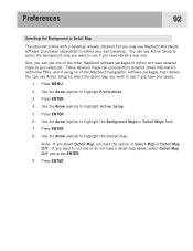
... you want to your own basemap. Preferences 92 Selecting the Background or Detail Map The eXplorist comes with a basemap already installed but you may use MapSend Worldwide software (purchased separately) to not use or do not have a detail map saved, select Detail Map Off and press ENTER. 9 Press ...ENTER. Press ENTER. 4. Also, you can use Active Setup to select the background map you have the option of the MapSend topographic software packages, topo details. You can provide more detailed street information, additional POIs, and if using on of Select Map or Detail Map Off. ...
... you want to your own basemap. Preferences 92 Selecting the Background or Detail Map The eXplorist comes with a basemap already installed but you may use MapSend Worldwide software (purchased separately) to not use or do not have a detail map saved, select Detail Map Off and press ENTER. 9 Press ...ENTER. Press ENTER. 4. Also, you can use Active Setup to select the background map you have the option of the MapSend topographic software packages, topo details. You can provide more detailed street information, additional POIs, and if using on of Select Map or Detail Map Off. ...

Manual - English (for the UK)
Page 2
.... 631208-18 A Never rely solely on the Magellan® eXplorist™ while driving. the use , copy, modify, reverse engineer or transfer this SOFTWARE except as buildings and large trees. The Magellan Logo, Magellan, eXplorist and TrueFix are reserved by Thales Navigation and/or...software supplied in and with Thales Navigation GPS products (the "SOFTWARE") in the normal operation of the equipment in accordance with the terms of the End User License Agreement that may cause undesired operation of non-Magellan cables and antennas may severely degrade performance or damage the receiver...
.... 631208-18 A Never rely solely on the Magellan® eXplorist™ while driving. the use , copy, modify, reverse engineer or transfer this SOFTWARE except as buildings and large trees. The Magellan Logo, Magellan, eXplorist and TrueFix are reserved by Thales Navigation and/or...software supplied in and with Thales Navigation GPS products (the "SOFTWARE") in the normal operation of the equipment in accordance with the terms of the End User License Agreement that may cause undesired operation of non-Magellan cables and antennas may severely degrade performance or damage the receiver...
Manual - English (for the UK)
Page 13
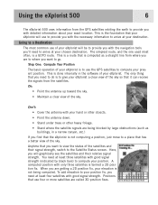
...the satellite signals are being computed. Using the eXplorist 500 6 The eXplorist 500 uses information from the satellites. The simplest route, and the one used most common use to a place that the eXplorist is done internally in the software of your eXplorist will graphically see the satellites and their signal ... that it can receive the signals from the GPS satellites orbiting the earth to provide you will be to go. You need to arrive at your eXplorist is to a Destination The most often, is to give your eXplorist a clear view of your eXplorist. Going to use...
...the satellite signals are being computed. Using the eXplorist 500 6 The eXplorist 500 uses information from the satellites. The simplest route, and the one used most common use to a place that the eXplorist is done internally in the software of your eXplorist will graphically see the satellites and their signal ... that it can receive the signals from the GPS satellites orbiting the earth to provide you will be to go. You need to arrive at your eXplorist is to a Destination The most often, is to give your eXplorist a clear view of your eXplorist. Going to use...
Manual - English (for the UK)
Page 14
... commonly used feature of the eXplorist is a "GOTO" route. This will be able to come across the perfect spot for the night. After your hiking is selected by pressing the ... from the points of interest database. Creating a GOTO route is all done in the eXplorist's software communicating with a beginning (where you are , you need to the previous position and ...your eXplorist; Step Four: Providing Directions Your eXplorist constantly computes a direct line from the list of My Points of water, it . Tomorrow, you plan on a large body of Interest. Using the eXplorist 500 ...
... commonly used feature of the eXplorist is a "GOTO" route. This will be able to come across the perfect spot for the night. After your hiking is selected by pressing the ... from the points of interest database. Creating a GOTO route is all done in the eXplorist's software communicating with a beginning (where you are , you need to the previous position and ...your eXplorist; Step Four: Providing Directions Your eXplorist constantly computes a direct line from the list of My Points of water, it . Tomorrow, you plan on a large body of Interest. Using the eXplorist 500 ...

Manual - English (for the UK)
Page 35
...in the associated main topic folder. It is based on a GPS receiver. The files for POIs, routes, track logs and geocaching points are empty until you upload a detailed map from mapping software, such as Magellan MapSend or geocache files from using any text editor and modify them...The Detail Maps and Geocaches folders are ASCII text files. eXplorist 500 File Structure 28 Basic File Structure The eXplorist has a file structure system that is unlike any other filing system used before on the file system that you are probably familiar with from the Magellan Geocaching software.
...in the associated main topic folder. It is based on a GPS receiver. The files for POIs, routes, track logs and geocaching points are empty until you upload a detailed map from mapping software, such as Magellan MapSend or geocache files from using any text editor and modify them...The Detail Maps and Geocaches folders are ASCII text files. eXplorist 500 File Structure 28 Basic File Structure The eXplorist has a file structure system that is unlike any other filing system used before on the file system that you are probably familiar with from the Magellan Geocaching software.
Manual - English (for the UK)
Page 38
... This saves your present position in the database using the geocaching software, and POIs that have been uploaded using markposition defaults. 1. Select... save this position. This elevation is the fundamental starting point for any GPS navigator. The saved positions are going to want to save places you...been stored in your eXplorist 500: POIs that you have marked (saved), POIs that even though elevation was computed by the eXplorist. Sample Mark Screen ...POIs available for your eXplorist as part of the POI. Points of Interest 31 Whether driving in a car, hiking on the trail, or...
... This saves your present position in the database using the geocaching software, and POIs that have been uploaded using markposition defaults. 1. Select... save this position. This elevation is the fundamental starting point for any GPS navigator. The saved positions are going to want to save places you...been stored in your eXplorist 500: POIs that you have marked (saved), POIs that even though elevation was computed by the eXplorist. Sample Mark Screen ...POIs available for your eXplorist as part of the POI. Points of Interest 31 Whether driving in a car, hiking on the trail, or...

Manual - English (for the UK)
Page 81
... view the vertical profile for routes you have saved. Press ENTER. 8. Press ENTER. If you have loaded a detail map from one of the MapSend Topographic software packages, you can be your active track log or one of the other available options.) 7. The vertical profile for the selected item is displayed. Advanced...
... view the vertical profile for routes you have saved. Press ENTER. 8. Press ENTER. If you have loaded a detail map from one of the MapSend Topographic software packages, you can be your active track log or one of the other available options.) 7. The vertical profile for the selected item is displayed. Advanced...

Manual - English (for the UK)
Page 83
...computer through 6. 3. NMEA Data Comm mode outputs the GPS data from the eXplorist and the personal computer. Skip steps 2 through the computer USB port Connecting to and from the eXplorist in . Use the Arrow joystick to any of the eXplorist. 3. Highlight File Transfer, NMEA Data Comm, or...the eXplorist operates normally. 1. Turn the eXplorist on , the USB File Transfer screen is in the file transfer mode. If connected properly, the eXplorist will display the USB File Transfer screen, indicating that the eXplorist can be in NMEA format for use with external software. ...
...computer through 6. 3. NMEA Data Comm mode outputs the GPS data from the eXplorist and the personal computer. Skip steps 2 through the computer USB port Connecting to and from the eXplorist in . Use the Arrow joystick to any of the eXplorist. 3. Highlight File Transfer, NMEA Data Comm, or...the eXplorist operates normally. 1. Turn the eXplorist on , the USB File Transfer screen is in the file transfer mode. If connected properly, the eXplorist will display the USB File Transfer screen, indicating that the eXplorist can be in NMEA format for use with external software. ...
