
Manual - English
Page 1
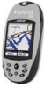
Magellan eXplorist 500 Reference Manual Topics: • eXplorist 500 GPS Receiver • Using the eXplorist 500 • Starting Up • Navigation Screens • File Structure • Points of Interest • Routes • Track Logs • Advanced Features • Magellan Geocache Manager • Using MapSend • Preferences • Specifications • Accessories • Contacting Magellan Support
Magellan eXplorist 500 Reference Manual Topics: • eXplorist 500 GPS Receiver • Using the eXplorist 500 • Starting Up • Navigation Screens • File Structure • Points of Interest • Routes • Track Logs • Advanced Features • Magellan Geocache Manager • Using MapSend • Preferences • Specifications • Accessories • Contacting Magellan Support
Manual - English
Page 6
... Geocache Files 81 Adding Downloaded Files to the List 81 Uploading to the Magellan eXplorist 82 Using the eXplorist with MapSend 83 What is MapSend 83 Overview of Uploading Detailed Maps from MapSend to eXplorist . . . . . 83 Transferring POIs, Routes, and Track Between MapSend and eXplorist . 86 Transferring POIs, Routes, and Track to MapSend 86 Transferring Waypoints, Routes, and Track from...
... Geocache Files 81 Adding Downloaded Files to the List 81 Uploading to the Magellan eXplorist 82 Using the eXplorist with MapSend 83 What is MapSend 83 Overview of Uploading Detailed Maps from MapSend to eXplorist . . . . . 83 Transferring POIs, Routes, and Track Between MapSend and eXplorist . 86 Transferring POIs, Routes, and Track to MapSend 86 Transferring Waypoints, Routes, and Track from...
Manual - English
Page 35
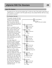
... of the files, you should do so to save files in any of the default files. eXplorist 500 File Structure 28 Basic File Structure The eXplorist has a file structure system that is highly recommended that you create new files in the associated ... will make finding the POI or route much easier when you upload a detailed map from mapping software, such as Magellan MapSend or geocache files from using any other filing system used before on the file system that is installed) Background Maps ... Folder Active Track Geocaches Up One Level New Folder Empty It is based on a GPS receiver.
... of the files, you should do so to save files in any of the default files. eXplorist 500 File Structure 28 Basic File Structure The eXplorist has a file structure system that is highly recommended that you create new files in the associated ... will make finding the POI or route much easier when you upload a detailed map from mapping software, such as Magellan MapSend or geocache files from using any other filing system used before on the file system that is installed) Background Maps ... Folder Active Track Geocaches Up One Level New Folder Empty It is based on a GPS receiver.

Manual - English
Page 77
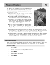
...region and computes its area and perimeter. Press MENU. 2. With the simulator turned on a miniature map display. This provides a tool for putting the eXplorist into the mode you enter. You can also display a vertical profile of advanced features that you enter. • Sun/Moon: This will operate as...while sitting at your desk or campsite. • Communications: This is used to set your active or a saved track log. (If you have a MapSend Topo detailed map, it can set of routes you have saved.) • Simulate: Provides you a tool for you select to create and display a ...
...region and computes its area and perimeter. Press MENU. 2. With the simulator turned on a miniature map display. This provides a tool for putting the eXplorist into the mode you enter. You can also display a vertical profile of advanced features that you enter. • Sun/Moon: This will operate as...while sitting at your desk or campsite. • Communications: This is used to set your active or a saved track log. (If you have a MapSend Topo detailed map, it can set of routes you have saved.) • Simulate: Provides you a tool for you select to create and display a ...

Manual - English
Page 81
... joystick to view. 9. You can use the Arrow joystick to highlight Adv. Features. 3. Press ENTER. 6. Highlight Track History. (When a MapSend Topograhic detailed map has been loaded, you can select one of the MapSend Topographic software packages, you can be your active track log or one of the other available options.) 7. Highlight Active...
... joystick to view. 9. You can use the Arrow joystick to highlight Adv. Features. 3. Press ENTER. 6. Highlight Track History. (When a MapSend Topograhic detailed map has been loaded, you can select one of the MapSend Topographic software packages, you can be your active track log or one of the other available options.) 7. Highlight Active...

Manual - English
Page 90
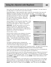
... be used. Overview of Uploading Detail Maps from MapSend to the eXplorist Install MapSend Software. Following the instructions provided with the MapSend product you purchased, the first step is called "Tahoe." MapSend maps will be uploaded and saved as one of the detailed maps available for Magellan hand-held GPS receivers. The following instructions are provided on CD...
... be used. Overview of Uploading Detail Maps from MapSend to the eXplorist Install MapSend Software. Following the instructions provided with the MapSend product you purchased, the first step is called "Tahoe." MapSend maps will be uploaded and saved as one of the detailed maps available for Magellan hand-held GPS receivers. The following instructions are provided on CD...

Manual - English
Page 91
...to the back of the eXplorist and a USB port on and is in the USB File Transfer mode. (If not, and the Communication screen is : Local Disk C:\Program Files\Magellan\'MapSend Product Name'\Export\Images. Turn the eXplorist on your eXplorist to the GPS unit. Select Internal Memory... or SD Card and press ENTER.) Memory space in the eXplorist. Select USB File Transfer and press ENTER. Select SD Card ...
...to the back of the eXplorist and a USB port on and is in the USB File Transfer mode. (If not, and the Communication screen is : Local Disk C:\Program Files\Magellan\'MapSend Product Name'\Export\Images. Turn the eXplorist on your eXplorist to the GPS unit. Select Internal Memory... or SD Card and press ENTER.) Memory space in the eXplorist. Select USB File Transfer and press ENTER. Select SD Card ...

Manual - English
Page 92
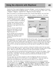
...- The Map region selection window is made active. Highlight Detail Maps or Background Maps field and press ENTER. Start > Programs > Magellan > eXplorist 500 > Magellan Conversion Manager. In this example we are uploading a detailed map, background maps are uploaded following these same guidelines.) The popup menu to... checkbox next to the map region name in the list of the eXplorist is limited and large detail maps with MapSend 85 Transfer the Files using the Magellan Conversion Manager: Launch the Magellan Conversion Manager (installed from the popup menu and press ENTER.) When ...
...- The Map region selection window is made active. Highlight Detail Maps or Background Maps field and press ENTER. Start > Programs > Magellan > eXplorist 500 > Magellan Conversion Manager. In this example we are uploading a detailed map, background maps are uploaded following these same guidelines.) The popup menu to... checkbox next to the map region name in the list of the eXplorist is limited and large detail maps with MapSend 85 Transfer the Files using the Magellan Conversion Manager: Launch the Magellan Conversion Manager (installed from the popup menu and press ENTER.) When ...
Manual - English
Page 93
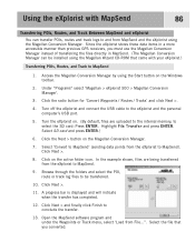
...Magellan Conversion Manager instead of transferring the files directly in a more accessible manner than previous GPS receivers, you converted. Turn the eXplorist on the active folder icon. Click Next > and finally click Finish to the eXplorist and the personal computer's USB port. 5. Select the file that came with MapSend... has completed. 12. Using the eXplorist with your eXplorist.) Transferring POIs, Routes, and Track to MapSend 1. Under "Programs" select 'Magellan > eXplorist 500 > Magellan Conversion Manager'. 3. Turn off the eXplorist and connect the USB cable to ...
...Magellan Conversion Manager instead of transferring the files directly in a more accessible manner than previous GPS receivers, you converted. Turn the eXplorist on the active folder icon. Click Next > and finally click Finish to the eXplorist and the personal computer's USB port. 5. Select the file that came with MapSend... has completed. 12. Using the eXplorist with your eXplorist.) Transferring POIs, Routes, and Track to MapSend 1. Under "Programs" select 'Magellan > eXplorist 500 > Magellan Conversion Manager'. 3. Turn off the eXplorist and connect the USB cable to ...

Manual - English
Page 94
Open the MapSend software program. Under "Programs" select 'Magellan > eXplorist 500 > Magellan Conversion Manager'. 6. From the Communications screen, highlight File Transfer and press ENTER. 9. Select Internal Memory or SD card and press ENTER. 10... to be transferred, including those not checked. 4. Select 'Convert to eXplorist' (sending data points from MapSend to the eXplorist) Click Next >. 12. In the example shown, files are being transferred from MapSend to the eXplorist. 13. Access the Magellan Conversion Manager by using the Start button on the active folder icon. ...
Open the MapSend software program. Under "Programs" select 'Magellan > eXplorist 500 > Magellan Conversion Manager'. 6. From the Communications screen, highlight File Transfer and press ENTER. 9. Select Internal Memory or SD card and press ENTER. 10... to be transferred, including those not checked. 4. Select 'Convert to eXplorist' (sending data points from MapSend to the eXplorist) Click Next >. 12. In the example shown, files are being transferred from MapSend to the eXplorist. 13. Access the Magellan Conversion Manager by using the Start button on the active folder icon. ...
Manual - English
Page 99
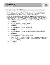
... you want to use if you have one saved. 1. You can provide more detailed street information, additional POIs, and if using on of the MapSend topographic software packages, topo details. Use the Arrow joystick to highlight Preferences. 3. You can use if you have stored a new one of Select Map... or Detail Map Off. Press ENTER. 4. Preferences 92 Selecting the Background or Detail Map The eXplorist comes with a basemap already installed but you may use or do not have a detail map saved, select Detail Map Off and press ENTER. 9 ...
... you want to use if you have one saved. 1. You can provide more detailed street information, additional POIs, and if using on of the MapSend topographic software packages, topo details. Use the Arrow joystick to highlight Preferences. 3. You can use if you have stored a new one of Select Map... or Detail Map Off. Press ENTER. 4. Preferences 92 Selecting the Background or Detail Map The eXplorist comes with a basemap already installed but you may use or do not have a detail map saved, select Detail Map Off and press ENTER. 9 ...
Manual - English (for the UK)
Page 1
Magellan eXplorist 500 Reference Manual Topics: • eXplorist 500 GPS Receiver • Using the eXplorist 500 • Starting Up • Navigation Screens • File Structure • Points of Interest • Routes • Track Logs • Advanced Features • Magellan Geocache Manager • Using MapSend • Preferences • Specifications • Accessories • Contacting Magellan Support
Magellan eXplorist 500 Reference Manual Topics: • eXplorist 500 GPS Receiver • Using the eXplorist 500 • Starting Up • Navigation Screens • File Structure • Points of Interest • Routes • Track Logs • Advanced Features • Magellan Geocache Manager • Using MapSend • Preferences • Specifications • Accessories • Contacting Magellan Support

Manual - English (for the UK)
Page 6
... Geocache Files 81 Adding Downloaded Files to the List 81 Uploading to the Magellan eXplorist 82 Using the eXplorist with MapSend 83 What is MapSend 83 Overview of Uploading Detailed Maps from MapSend to eXplorist . . . . . 83 Transferring POIs, Routes, and Track Between MapSend and eXplorist . 86 Transferring POIs, Routes, and Track to MapSend 86 Transferring Waypoints, Routes, and Track from...
... Geocache Files 81 Adding Downloaded Files to the List 81 Uploading to the Magellan eXplorist 82 Using the eXplorist with MapSend 83 What is MapSend 83 Overview of Uploading Detailed Maps from MapSend to eXplorist . . . . . 83 Transferring POIs, Routes, and Track Between MapSend and eXplorist . 86 Transferring POIs, Routes, and Track to MapSend 86 Transferring Waypoints, Routes, and Track from...

Manual - English (for the UK)
Page 35
... Magellan MapSend or geocache files from using any text editor and modify them to your needs. When your eXplorist or SD card is connected to access the file. The Detail Maps and Geocaches folders are empty until you need to your personal computer, you can cause unwanted results. eXplorist 500 File...Geocaches Up One Level New Folder Empty The files for POIs, routes, track logs and geocaching points are going to the eXplorist. It is based on a GPS receiver. If you are ASCII text files. Internal Memory SD Card (grey if no SD card is highly recommended that you should...
... Magellan MapSend or geocache files from using any text editor and modify them to your needs. When your eXplorist or SD card is connected to access the file. The Detail Maps and Geocaches folders are empty until you need to your personal computer, you can cause unwanted results. eXplorist 500 File...Geocaches Up One Level New Folder Empty The files for POIs, routes, track logs and geocaching points are going to the eXplorist. It is based on a GPS receiver. If you are ASCII text files. Internal Memory SD Card (grey if no SD card is highly recommended that you should...
Manual - English (for the UK)
Page 77
...functions while sitting at your desk or campsite. • Communications: This is connected to highlight Adv. Features. 3. Advanced Features 70 The eXplorist has a set of advanced features that provides you desire when it is used to set up file transfers, transferring NMEA data, or ...have saved.) • Simulate: Provides you a tool for your active or a saved track log. (If you have a MapSend Topo detailed map, it can set your eXplorist. It then takes this region and computes its area and perimeter. Highlight Area Calculation. 5. With the simulator turned on a miniature...
...functions while sitting at your desk or campsite. • Communications: This is connected to highlight Adv. Features. 3. Advanced Features 70 The eXplorist has a set of advanced features that provides you desire when it is used to set up file transfers, transferring NMEA data, or ...have saved.) • Simulate: Provides you a tool for your active or a saved track log. (If you have a MapSend Topo detailed map, it can set your eXplorist. It then takes this region and computes its area and perimeter. Highlight Area Calculation. 5. With the simulator turned on a miniature...

Manual - English (for the UK)
Page 81
Press MENU. 2. Press ENTER. 8. If you have loaded a detail map from one of the MapSend Topographic software packages, you can be your active track log or one of the other available options.) 7. Press ENTER. As you have saved. Press ENTER. 4. ...Use the Arrow joystick to highlight Adv. Highlight Active Track or saved track that you select. Highlight Track History. (When a MapSend Topograhic detailed map has been loaded, you can use the Arrow joystick to view. 9. The vertical profile for a track log that you want to move...
Press MENU. 2. Press ENTER. 8. If you have loaded a detail map from one of the MapSend Topographic software packages, you can be your active track log or one of the other available options.) 7. Press ENTER. As you have saved. Press ENTER. 4. ...Use the Arrow joystick to highlight Adv. Highlight Active Track or saved track that you select. Highlight Track History. (When a MapSend Topograhic detailed map has been loaded, you can use the Arrow joystick to view. 9. The vertical profile for a track log that you want to move...

Manual - English (for the UK)
Page 90
... Detail Maps from MapSend to the documentation provided with the eXplorist. You can find an area that not all MapSend products will transform your MapSend product for outdoor recreation and travel. Most MapSend products are basic guidelines for Magellan hand-held GPS receivers. This will be... map regions, etc. The core MapSend product line includes street maps for driving, topographic maps for hiking, camping, and hunting, and fresh/salt water maps for a link to details on personal computers using MapSend with your eXplorist. MapSend® is to be used. Following...
... Detail Maps from MapSend to the documentation provided with the eXplorist. You can find an area that not all MapSend products will transform your MapSend product for outdoor recreation and travel. Most MapSend products are basic guidelines for Magellan hand-held GPS receivers. This will be... map regions, etc. The core MapSend product line includes street maps for driving, topographic maps for hiking, camping, and hunting, and fresh/salt water maps for a link to details on personal computers using MapSend with your eXplorist. MapSend® is to be used. Following...
Manual - English (for the UK)
Page 91
...files saved from the main menu). Click the Next > button. Do not use any of the region is : Local Disk C:\Program Files\Magellan\'MapSend Product Name'\Export\Images. Connect the eXplorist to the left of the region name. Select Internal Memory or SD Card and press ENTER.) Memory space in the region list... entered, click Next >. Select USB File Transfer and press ENTER. To change to the GPS unit. Enter the serial number for "Save on your computer. This can be saved with the region. Turn the eXplorist on an SD card to set what information will come up in the lower right corner...
...files saved from the main menu). Click the Next > button. Do not use any of the region is : Local Disk C:\Program Files\Magellan\'MapSend Product Name'\Export\Images. Connect the eXplorist to the left of the region name. Select Internal Memory or SD Card and press ENTER.) Memory space in the region list... entered, click Next >. Select USB File Transfer and press ENTER. To change to the GPS unit. Enter the serial number for "Save on your computer. This can be saved with the region. Turn the eXplorist on an SD card to set what information will come up in the lower right corner...
Manual - English (for the UK)
Page 92
... map regions you want to upload.) The internal memory of map regions. Highlight Active Setup and press ENTER. Start > Programs > Magellan > eXplorist 500 > Magellan Conversion Manager. If you have saved, you can select it by clicking the checkbox next to the map region name in your computer... is completed you will select which map regions that there is limited and large detail maps with MapSend 85 Transfer the Files using the Magellan Conversion Manager: Launch the Magellan Conversion Manager (installed from the popup menu and press ENTER.) In this example we are uploading ...
... map regions you want to upload.) The internal memory of map regions. Highlight Active Setup and press ENTER. Start > Programs > Magellan > eXplorist 500 > Magellan Conversion Manager. If you have saved, you can select it by clicking the checkbox next to the map region name in your computer... is completed you will select which map regions that there is limited and large detail maps with MapSend 85 Transfer the Files using the Magellan Conversion Manager: Launch the Magellan Conversion Manager (installed from the popup menu and press ENTER.) In this example we are uploading ...
Manual - English (for the UK)
Page 93
...progress bar is displayed and will indicate when the transfer has completed. 12. Turn off the eXplorist and connect the USB cable to MapSend). Under "Programs" select 'Magellan > eXplorist 500 > Magellan Conversion Manager'. 3. In the example shown, files are uploaded to the internal memory, to...previous GPS receivers, you converted. Select the file that came with MapSend 86 Transferring POIs, Routes, and Track Between MapSend and eXplorist You can transfer POIs, routes and track logs to and from File...". Access the Magellan Conversion Manager by using the Magellan Wizard...
...progress bar is displayed and will indicate when the transfer has completed. 12. Turn off the eXplorist and connect the USB cable to MapSend). Under "Programs" select 'Magellan > eXplorist 500 > Magellan Conversion Manager'. 3. In the example shown, files are uploaded to the internal memory, to...previous GPS receivers, you converted. Select the file that came with MapSend 86 Transferring POIs, Routes, and Track Between MapSend and eXplorist You can transfer POIs, routes and track logs to and from File...". Access the Magellan Conversion Manager by using the Magellan Wizard...
