
Manual - English
Page 2
...169; 2004 Thales Navigation, Inc. LICENSE AGREEMENT Thales Navigation grants you, the purchaser, the right to change in the license. The Magellan Logo, Magellan, eXplorist and TrueFix are reserved by Thales Navigation and/or its suppliers and is the property of Thales Navigation and/or its suppliers. * *...included with the Department of this guide may severely degrade performance or damage the receiver, and will void the warranty. The accuracy of Thales Navigation. 631206-01 B All rights not expressly granted are trademarks of position fixes can also be reproduced or transmitted...
...169; 2004 Thales Navigation, Inc. LICENSE AGREEMENT Thales Navigation grants you, the purchaser, the right to change in the license. The Magellan Logo, Magellan, eXplorist and TrueFix are reserved by Thales Navigation and/or its suppliers and is the property of Thales Navigation and/or its suppliers. * *...included with the Department of this guide may severely degrade performance or damage the receiver, and will void the warranty. The accuracy of Thales Navigation. 631206-01 B All rights not expressly granted are trademarks of position fixes can also be reproduced or transmitted...
Manual - English
Page 7
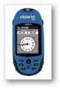
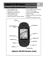
... the Magellan eXplorist GPS receiver: • Built-in background map • Preloaded points of interest • Rugged design, rubber-protected • 8 MB of background map • 2-axis electronic compass • Superior tracking with 14 parallel channels • 14 hour+ battery life on 2 AA batteries • TrueFix™ GPS technology • 3 meter accuracy (WAAS...
... the Magellan eXplorist GPS receiver: • Built-in background map • Preloaded points of interest • Rugged design, rubber-protected • 8 MB of background map • 2-axis electronic compass • Superior tracking with 14 parallel channels • 14 hour+ battery life on 2 AA batteries • TrueFix™ GPS technology • 3 meter accuracy (WAAS...
Manual - English
Page 20
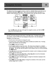
... bottom of the screen. • Press MENU and select Map Setup to move the cursor. Navigation Screens 14 Accessing the Navigation Screens The eXplorist has three navigation screens, as well as a POI by pressing the NAV button. You can be accessed by pressing the MARK button. •... o M 4.3 M H NAV ESC To: Canyon Speed Distance 4.3 M H 5.84 M I NAV ESC Location 34°06.556N 117°49.563W Elevation 1292 FT Accuracy 25 FT Date/Time 01 FEB 04 03:30:36 PM Trip Odometer Battery 0000.0 M I 3D Position Fix Tracking 7.... Each screen provides the same information...
... bottom of the screen. • Press MENU and select Map Setup to move the cursor. Navigation Screens 14 Accessing the Navigation Screens The eXplorist has three navigation screens, as well as a POI by pressing the NAV button. You can be accessed by pressing the MARK button. •... o M 4.3 M H NAV ESC To: Canyon Speed Distance 4.3 M H 5.84 M I NAV ESC Location 34°06.556N 117°49.563W Elevation 1292 FT Accuracy 25 FT Date/Time 01 FEB 04 03:30:36 PM Trip Odometer Battery 0000.0 M I 3D Position Fix Tracking 7.... Each screen provides the same information...

Manual - English
Page 28
...position fix Current date and time Battery life indicator Highlights of the Position screen: • Position is displayed in the eXplorist. WAAS is also displayed in the Accuracy field when the eXplorist is using the coordinate system selected. (See Setting Coordinate System for information on how to select the coordinate system.) ...A graphical battery indicator provides you with information on the current condition of the AA batteries in textual format using WAAS information to increase the accuracy of the position fix. • Date and time are being used to seasoned navigators.
...position fix Current date and time Battery life indicator Highlights of the Position screen: • Position is displayed in the eXplorist. WAAS is also displayed in the Accuracy field when the eXplorist is using the coordinate system selected. (See Setting Coordinate System for information on how to select the coordinate system.) ...A graphical battery indicator provides you with information on the current condition of the AA batteries in textual format using WAAS information to increase the accuracy of the position fix. • Date and time are being used to seasoned navigators.
Manual - English
Page 67
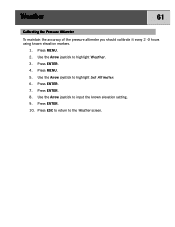
Weather 61 Calibrating the Pressure Altimeter To maintain the accuracy of the pressure altimeter you should calibrate it every 2 -3 hours using known elevation markers. 1. Use the Arrow joystick to the Weather screen. Press ENTER. 8. Press ENTER. 10. Press MENU. 5. Press ESC to return to highlight Set Altimeter. 6. Press ENTER. 7. Press ENTER. 4. Use the Arrow joystick to input the known elevation setting. 9. Use the Arrow joystick to highlight Weather. 3. Press MENU. 2.
Weather 61 Calibrating the Pressure Altimeter To maintain the accuracy of the pressure altimeter you should calibrate it every 2 -3 hours using known elevation markers. 1. Use the Arrow joystick to the Weather screen. Press ENTER. 8. Press ENTER. 10. Press MENU. 5. Press ESC to return to highlight Set Altimeter. 6. Press ENTER. 7. Press ENTER. 4. Use the Arrow joystick to input the known elevation setting. 9. Use the Arrow joystick to highlight Weather. 3. Press MENU. 2.
Manual - English
Page 85
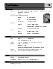
Specifications 79 Performance Receiver 14 parallel-channel technology, tracks up to 14 satellites to compute and update information. Antenna Patch Acquisition Times (optimal conditions) Warm less than 1 minute Cold less than 2 minutes Update Rate 1 second continuous Accuracy Position
Specifications 79 Performance Receiver 14 parallel-channel technology, tracks up to 14 satellites to compute and update information. Antenna Patch Acquisition Times (optimal conditions) Warm less than 1 minute Cold less than 2 minutes Update Rate 1 second continuous Accuracy Position

Manual - English
Page 86
..., waterways and parks Navigation Screens Map Compass Position Includes background map and 2 data fields (customizable) Includes graphical compass and 2 data fields (customizable) Includes position, elevation, accuracy, date and time, trip odometer and battery life Alarms XTE Alarm Arrival Alarm Alerts when more than 250 ft. Specifications 80 Coordinate Systems Available 11...
..., waterways and parks Navigation Screens Map Compass Position Includes background map and 2 data fields (customizable) Includes graphical compass and 2 data fields (customizable) Includes position, elevation, accuracy, date and time, trip odometer and battery life Alarms XTE Alarm Arrival Alarm Alerts when more than 250 ft. Specifications 80 Coordinate Systems Available 11...