
Manual - English
Page 9
... more. SD-card expansion - (Triton 400 & 500 only) Use an optional SD memory card to add detailed maps - The Magellan Triton was designed for additional information and tips on the use - Simple menus and an intuitive interface makes using the Magellan Triton easy for the Magellan Triton 300, loaded onto the internal memory. A built-in the Magellan Triton or, for first time GPS receiver users while...
... more. SD-card expansion - (Triton 400 & 500 only) Use an optional SD memory card to add detailed maps - The Magellan Triton was designed for additional information and tips on the use - Simple menus and an intuitive interface makes using the Magellan Triton easy for the Magellan Triton 300, loaded onto the internal memory. A built-in the Magellan Triton or, for first time GPS receiver users while...
Manual - English
Page 10
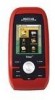
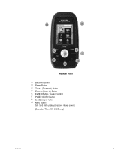
A B C E F G D I H Magellan Triton A Backlight Button B Power Button C Zoom - (Zoom out) Button D Zoom + (Zoom in) Button E ENTER Button / Cursor Control F PAGE / GO TO Button G Esc (Escape) Button H Menu Button I SD Card Slot (under protective rubber cover) [Magellan Triton 400 & 500 only] Overview 2
A B C E F G D I H Magellan Triton A Backlight Button B Power Button C Zoom - (Zoom out) Button D Zoom + (Zoom in) Button E ENTER Button / Cursor Control F PAGE / GO TO Button G Esc (Escape) Button H Menu Button I SD Card Slot (under protective rubber cover) [Magellan Triton 400 & 500 only] Overview 2

Manual - English
Page 11
... backlit Internal memory or Secure Digital (SD) Card (optional accessory) Built-in base map of the continental United States and Canada. (In Europe, base map coverage may vary.) 4.65" x 2.16" x 1.22" (11.8 x 5.5 x 3.1 cm) 6.6 oz (187 g) - WAAS/EGNOS, < 7 meters (15 feet) - GPS only English, French, German, Dutch,..., IPX-7 Built-in multidirectional patch Nine direct-access keys 14° to 140°F (-10° to 60°C) PERFORMANCE Receiver Acquisition Time Update Rate Accuracy Languages Coordinate Systems SiRF Star III™ 20 channels, WAAS/EGNOS Hot: 20 seconds, Cold: 60 ...
... backlit Internal memory or Secure Digital (SD) Card (optional accessory) Built-in base map of the continental United States and Canada. (In Europe, base map coverage may vary.) 4.65" x 2.16" x 1.22" (11.8 x 5.5 x 3.1 cm) 6.6 oz (187 g) - WAAS/EGNOS, < 7 meters (15 feet) - GPS only English, French, German, Dutch,..., IPX-7 Built-in multidirectional patch Nine direct-access keys 14° to 140°F (-10° to 60°C) PERFORMANCE Receiver Acquisition Time Update Rate Accuracy Languages Coordinate Systems SiRF Star III™ 20 channels, WAAS/EGNOS Hot: 20 seconds, Cold: 60 ...

Manual - English
Page 14
...Scroll down and select Power Options. 5. Menus Accessing the features of the internal base map or a destination waypoint found on an optional SD card (400 & 500) or into the Magellan Triton. From the Map Screen, press MENU. The Waypoint option provides a way to create a Go To route to a waypoint that you...one of these are used to activate. You can select the trail that you would like to automatically go into the Magellan Triton as part of the Magellan Triton is used to create waypoints and multileg routes that you have been pressed. The Trips option will turn off with no...
...Scroll down and select Power Options. 5. Menus Accessing the features of the internal base map or a destination waypoint found on an optional SD card (400 & 500) or into the Magellan Triton. From the Map Screen, press MENU. The Waypoint option provides a way to create a Go To route to a waypoint that you...one of these are used to activate. You can select the trail that you would like to automatically go into the Magellan Triton as part of the Magellan Triton is used to create waypoints and multileg routes that you have been pressed. The Trips option will turn off with no...
Manual - English
Page 16
...Select the data type desired from the list shown and press ENTER. 6. Magellan Triton 300 installs the National Geographic maps into their internal memory, while Magellan Triton 400 and 500 stores the maps on an SD card. Select Maps. 4. Customizing the Data Field for the Map Screen 1. ...including National Geographic maps, can change and with the data field customized to change what information is being displayed from the Magellan Store and installed using the optional National Geographic software. Customizing the Data Field for the Large Data, Compass or Satellite...
...Select the data type desired from the list shown and press ENTER. 6. Magellan Triton 300 installs the National Geographic maps into their internal memory, while Magellan Triton 400 and 500 stores the maps on an SD card. Select Maps. 4. Customizing the Data Field for the Map Screen 1. ...including National Geographic maps, can change and with the data field customized to change what information is being displayed from the Magellan Store and installed using the optional National Geographic software. Customizing the Data Field for the Large Data, Compass or Satellite...
Manual - English
Page 40
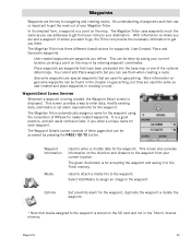
... screen also provides information on the direction and distance to the waypoint from your home to the Triton memory. Waypoints 32 In its simplest form, a waypoint is displayed. The Magellan Triton has three different classifications for newly created waypoints. User-created waypoints are and a waypoint of the... waypoint. * Note that media assigned to the waypoint is stored on the SD card and not in the chapter on geocaching, but you can be done by pressing the PAGE / GO TO button. The Magellan Triton uses waypoints much the same as user-created and place waypoints in creating ...
... screen also provides information on the direction and distance to the waypoint from your home to the Triton memory. Waypoints 32 In its simplest form, a waypoint is displayed. The Magellan Triton has three different classifications for newly created waypoints. User-created waypoints are and a waypoint of the... waypoint. * Note that media assigned to the waypoint is stored on the SD card and not in the chapter on geocaching, but you can be done by pressing the PAGE / GO TO button. The Magellan Triton uses waypoints much the same as user-created and place waypoints in creating ...

Manual - English
Page 50
...transfer the information into the Magellan Triton. From the Map screen, press MENU. 2. Select Go To. The Waypoint Information page is a popular activity with 5 being the most difficult), Terrain (1 though 5 with GPS users. Scroll down the page to help in the Triton. 8. Editing a Saved Geocache... Geocaching 42 icon to the Information page. They post these geocache waypoints into your Magellan Triton either by creating a geocache waypoint or by saving the geocache file from the SD card installed in finding the cache. Premium members of the person who hid the cache ...
...transfer the information into the Magellan Triton. From the Map screen, press MENU. 2. Select Go To. The Waypoint Information page is a popular activity with 5 being the most difficult), Terrain (1 though 5 with GPS users. Scroll down the page to help in the Triton. 8. Editing a Saved Geocache... Geocaching 42 icon to the Information page. They post these geocache waypoints into your Magellan Triton either by creating a geocache waypoint or by saving the geocache file from the SD card installed in finding the cache. Premium members of the person who hid the cache ...
Manual - English
Page 65
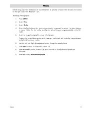
Media Before using any of the media options you need install an optional SD card in full screen. Select Media. 4. Use the Left and Right Arrow keypad to the Browse Photos list. 8. Media 57 Select View. 3. Select an image to ... the images are images available on the right side of the Magellan Triton. by date, distance or name. (Note: The Sort button is not active unless there are displayed. 9. Press + ZOOM to display the image in the SD card slot located on the SD card.) 5. Press MENU. 2. Select the Sort button at the top to choose...
Media Before using any of the media options you need install an optional SD card in full screen. Select Media. 4. Use the Left and Right Arrow keypad to the Browse Photos list. 8. Media 57 Select View. 3. Select an image to ... the images are images available on the right side of the Magellan Triton. by date, distance or name. (Note: The Sort button is not active unless there are displayed. 9. Press + ZOOM to display the image in the SD card slot located on the SD card.) 5. Press MENU. 2. Select the Sort button at the top to choose...


