Manual - English
Page 8
...Multileg Route 48 Duplicating a Multileg Route 48 Viewing a Route's Vertical Profile 48 Cancelling a Route 49 Trails ...50 Creating a Trail 50 Creating a Trail (Alternate method 50 Activating a Trail 50 Deleting a Trail 51 Deleting a Trail (Alternate Method 51 Duplicating a Trail 52 Reversing a Trail 52 Hiding/Showing a Trail 52 Activating a Backtrack Route 53 Clearing Track 53 Places ...54 Go To a Place Waypoint (base ... a Place Waypoint 55 Viewing Sun and Moon Rise and Set Times for a Place Waypoint 56 Media ...57 Browsing Photographs 57 Table of Contents Magellan Triton 4
...Multileg Route 48 Duplicating a Multileg Route 48 Viewing a Route's Vertical Profile 48 Cancelling a Route 49 Trails ...50 Creating a Trail 50 Creating a Trail (Alternate method 50 Activating a Trail 50 Deleting a Trail 51 Deleting a Trail (Alternate Method 51 Duplicating a Trail 52 Reversing a Trail 52 Hiding/Showing a Trail 52 Activating a Backtrack Route 53 Clearing Track 53 Places ...54 Go To a Place Waypoint (base ... a Place Waypoint 55 Viewing Sun and Moon Rise and Set Times for a Place Waypoint 56 Media ...57 Browsing Photographs 57 Table of Contents Magellan Triton 4

Manual - English
Page 14
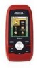
... the Magellan Triton is used to create waypoints and multileg routes that can be available in a future update. You can select the trail that the Triton will be saved by entering the coordinates for information on updates to your present location, by selecting a point on an optional SD card (400 & 500) or into the Magellan Triton. Check the Magellan...
... the Magellan Triton is used to create waypoints and multileg routes that can be available in a future update. You can select the trail that the Triton will be saved by entering the coordinates for information on updates to your present location, by selecting a point on an optional SD card (400 & 500) or into the Magellan Triton. Check the Magellan...

Manual - English
Page 15
...GO TO or ESC button. (There are two additional screens, Strip Compass and Road Compass, that are creating audio clips and playing MP3 music files. (Magellan Triton 400 & 500 only). hiking, marine use again to follow your current location and go to your travels since the last time track was... map. Press ESC to close the menu. While viewing the Speedometer screen, press MENU. Press ESC to close the contextual menu. The Trail option provides a way for taking and viewing photographs and movie clips. Accessing the Map Screen Contextual Menu 1. While viewing the Map screen,...
...GO TO or ESC button. (There are two additional screens, Strip Compass and Road Compass, that are creating audio clips and playing MP3 music files. (Magellan Triton 400 & 500 only). hiking, marine use again to follow your current location and go to your travels since the last time track was... map. Press ESC to close the menu. While viewing the Speedometer screen, press MENU. Press ESC to close the contextual menu. The Trail option provides a way for taking and viewing photographs and movie clips. Accessing the Map Screen Contextual Menu 1. While viewing the Map screen,...
Manual - English
Page 58
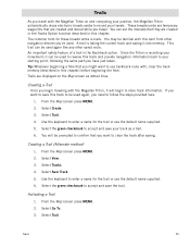
... default name supplied. 5. Select Go To. 3. The common term for the trail or use backtrack route with the Magellan Triton, it into memory. Tip: Whenever beginning a hike that you want to accept and save your movement, it can set the intervals that are created in the Tracks Option function described in this chapter) before beginning...
... default name supplied. 5. Select Go To. 3. The common term for the trail or use backtrack route with the Magellan Triton, it into memory. Tip: Whenever beginning a hike that you want to accept and save your movement, it can set the intervals that are created in the Tracks Option function described in this chapter) before beginning...
Manual - English
Page 61
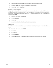
... Backtrack. 3. Accept the notification that directions back to camp are only a button press away. 1. Select Yes. 4. Select Tracks. 4. Trails 53 Being able to quickly create a route back to display the Options page. 8. Select View. 3. From the Map screen press MENU. 2. Press the PAGE / GO TO button to your starting point ... you should clear your journey. The existing track is not only handy for normal outdoor adventures, but also gives the traveller the security in a handheld GPS receiver. 6.
... Backtrack. 3. Accept the notification that directions back to camp are only a button press away. 1. Select Yes. 4. Select Tracks. 4. Trails 53 Being able to quickly create a route back to display the Options page. 8. Select View. 3. From the Map screen press MENU. 2. Press the PAGE / GO TO button to your starting point ... you should clear your journey. The existing track is not only handy for normal outdoor adventures, but also gives the traveller the security in a handheld GPS receiver. 6.

