
Triton User Manual Addendum - English, French, Spanish
Page 1
... and then resume recording your "footsteps". Triton User Manual Addendum This addendum applies to Triton GPS receivers that have a software version that you can set a user grid as the Coordinate System for the perimeter and area. Triton 300 Triton 400 Triton 500 Triton 1500 Triton 2000 01.90.00.0279 01.74.00.0278... that is displayed with the option of assigning a name to the saved track ("Trail"). The Triton receiver can now access the Main Menu on any of the Navigational screens by your Triton. It takes your current track (or a saved track or route) and computes the values for...
... and then resume recording your "footsteps". Triton User Manual Addendum This addendum applies to Triton GPS receivers that have a software version that you can set a user grid as the Coordinate System for the perimeter and area. Triton 300 Triton 400 Triton 500 Triton 1500 Triton 2000 01.90.00.0279 01.74.00.0278... that is displayed with the option of assigning a name to the saved track ("Trail"). The Triton receiver can now access the Main Menu on any of the Navigational screens by your Triton. It takes your current track (or a saved track or route) and computes the values for...

Triton User Manual Addendum - English, French, Spanish
Page 2
... Custom Position provides a way to the Satellite Status screen, press ENTER and select "Disable Custom Position". To turn the feature off and resume computing GPS position information, go to set to E. When you have an active route that contains mulitple legs you to navigate next too. When the route is... close to waypoint D and wish to the next waypoint in a Multileg Route. You can tell the Triton to go to the next destination (C) and repeat the process to go there instead of the receiver is disabled and the screen is activated it to go to view map areas other then your...
... Custom Position provides a way to the Satellite Status screen, press ENTER and select "Disable Custom Position". To turn the feature off and resume computing GPS position information, go to set to E. When you have an active route that contains mulitple legs you to navigate next too. When the route is... close to waypoint D and wish to the next waypoint in a Multileg Route. You can tell the Triton to go to the next destination (C) and repeat the process to go there instead of the receiver is disabled and the screen is activated it to go to view map areas other then your...

Manual - English
Page 2
... and good judgement. Never rely solely on the Magellan Triton while driving. Accuracy can be followed to GPS satellites made by any means, electronic or mechanical, including photocopying and recording, for the accuracy and maintenance of this guide may severely degrade performance or damage the receiver, and will void the warranty. When using the...
... and good judgement. Never rely solely on the Magellan Triton while driving. Accuracy can be followed to GPS satellites made by any means, electronic or mechanical, including photocopying and recording, for the accuracy and maintenance of this guide may severely degrade performance or damage the receiver, and will void the warranty. When using the...
Manual - English
Page 9
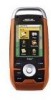
... to upload detailed maps and store media. 2 mega-pixel camera - (Triton 2000 only) Take clear beautiful pictures or videos of the Magellan Triton GPS receiver. Overview Thank you for your way back next time. Also visit the Magellan Triton support page at www.magellangps.com to your Triton. Ease-of changing weather conditions. Create a single leg Go To route...
... to upload detailed maps and store media. 2 mega-pixel camera - (Triton 2000 only) Take clear beautiful pictures or videos of the Magellan Triton GPS receiver. Overview Thank you for your way back next time. Also visit the Magellan Triton support page at www.magellangps.com to your Triton. Ease-of changing weather conditions. Create a single leg Go To route...

Manual - English
Page 11
... patch (or optional external antenna) Nine direct-access keys 14° to 140°F (-10° to 60°C) PERFORMANCE Receiver Acquisition Time Update Rate Accuracy Languages Coordinate Systems SiRF Star III™ 20 channels, WAAS/EGNOS Hot: 20 seconds, Cold: 60 ...seconds, Initial: 2 minutes Once per second 3 to 10 hours Overview 3 WAAS/EGNOS, < 7 meters (15 feet) - GPS only English, French, German, Dutch, Danish, Swedish, Spanish, Italian, Portuguese, Finnish, Norwegian Latitude/Longitude, UTM, OSGB, Irish, Swish, Swedish, Finnish, German, ...
... patch (or optional external antenna) Nine direct-access keys 14° to 140°F (-10° to 60°C) PERFORMANCE Receiver Acquisition Time Update Rate Accuracy Languages Coordinate Systems SiRF Star III™ 20 channels, WAAS/EGNOS Hot: 20 seconds, Cold: 60 ...seconds, Initial: 2 minutes Once per second 3 to 10 hours Overview 3 WAAS/EGNOS, < 7 meters (15 feet) - GPS only English, French, German, Dutch, Danish, Swedish, Spanish, Italian, Portuguese, Finnish, Norwegian Latitude/Longitude, UTM, OSGB, Irish, Swish, Swedish, Finnish, German, ...

Manual - English
Page 18
...slider to cycle through the backlight intensities. (Alternate method) 1. Press MENU. 2. Press the Backlight button (top left side of the receiver) to a lower level. Select Settings. 4. Select a low backlight level during nighttime use. 1. Select a short backlight timer setting ... slider to conserve the battery life in your Magellan Triton. Fundamentals 10 Select Settings. 4. Select Volume & Brightness. 5. Select View. Select View. 3. Disable the electronic compass if GPS fix is available. (Magellan Triton 2000) 1. Battery Life The following are things you...
...slider to cycle through the backlight intensities. (Alternate method) 1. Press MENU. 2. Press the Backlight button (top left side of the receiver) to a lower level. Select Settings. 4. Select a low backlight level during nighttime use. 1. Select a short backlight timer setting ... slider to conserve the battery life in your Magellan Triton. Fundamentals 10 Select Settings. 4. Select Volume & Brightness. 5. Select View. Select View. 3. Disable the electronic compass if GPS fix is available. (Magellan Triton 2000) 1. Battery Life The following are things you...

Manual - English
Page 27
... better the accuracy. This may decrease the accuracy (increase the number) such as heavy canopies from trees, tunnels, tall buildings, canyons, broadcast satellites, and other GPS receivers too close in distance) the progress the user has made . The smaller the number is travelling. If the user is moving away from the target...
... better the accuracy. This may decrease the accuracy (increase the number) such as heavy canopies from trees, tunnels, tall buildings, canyons, broadcast satellites, and other GPS receivers too close in distance) the progress the user has made . The smaller the number is travelling. If the user is moving away from the target...

Manual - English
Page 28
Map Screen Overview Battery Level Time of Day GPS Signal Strength North Indicator Data Fields Map Scale Pan Mode Map Legend Present Position Cursor (Points in the direction of travel .) Trail (Track that has been saved in the receiver.) Start Flag (Indicates the starting point of the active ...route.) End Flag (Indicates the ending point of the active route.) Waypoint (Indicates the position of waypoints saved in the Magellan Triton and it has a special contextual menu that can ...
Map Screen Overview Battery Level Time of Day GPS Signal Strength North Indicator Data Fields Map Scale Pan Mode Map Legend Present Position Cursor (Points in the direction of travel .) Trail (Track that has been saved in the receiver.) Start Flag (Indicates the starting point of the active ...route.) End Flag (Indicates the ending point of the active route.) Waypoint (Indicates the position of waypoints saved in the Magellan Triton and it has a special contextual menu that can ...

Manual - English
Page 38
... use the PAGE / GO TO button to select different pages for the Magellan Triton since the date is highlighted you will work as well. Date Entry The Magellan Triton uses a standard calendar display to select them from the GPS satellite. Page Selection Some screens like the Waypoint and Geocache Information screens, ...is another method to press the up arrow until one of the arrows in the month selector at the top of the calendar is automatically received from ; With the desired month displayed, select the date to be entered. (If the day portion of the display is highlighted.) Use...
... use the PAGE / GO TO button to select different pages for the Magellan Triton since the date is highlighted you will work as well. Date Entry The Magellan Triton uses a standard calendar display to select them from the GPS satellite. Page Selection Some screens like the Waypoint and Geocache Information screens, ...is another method to press the up arrow until one of the arrows in the month selector at the top of the calendar is automatically received from ; With the desired month displayed, select the date to be entered. (If the day portion of the display is highlighted.) Use...
Manual - English
Page 62
... a trail. 1. Select Yes. 4. Select View. 3. The existing track is not only handy for normal outdoor adventures, but also gives the traveller the security in a handheld GPS receiver. Use the cursor control to select the info icon to your journey. Select Hide Trail or Show Trail. Trails 54 From the Map screen press...
... a trail. 1. Select Yes. 4. Select View. 3. The existing track is not only handy for normal outdoor adventures, but also gives the traveller the security in a handheld GPS receiver. Use the cursor control to select the info icon to your journey. Select Hide Trail or Show Trail. Trails 54 From the Map screen press...


