Manual - English
Page 14
... provides a way to create a Go To route to a waypoint that you want the Triton to select a destination waypoint that has been loaded in a future update. You can select the trail that can select from your Magellan Triton. The Create Menu has the same options as the Go To Menu but these menu... options brings up the menu for a known waypoint. Select View. 3. Go To, Create and View. From the Map Screen, ...
... provides a way to create a Go To route to a waypoint that you want the Triton to select a destination waypoint that has been loaded in a future update. You can select the trail that can select from your Magellan Triton. The Create Menu has the same options as the Go To Menu but these menu... options brings up the menu for a known waypoint. Select View. 3. Go To, Create and View. From the Map Screen, ...

Manual - English
Page 16
...type desired from 20 different data type options. Once loaded, you want to change what information is active. 6. Select View. 3. Select the detailed map from the Magellan Store and loaded into the Magellan Triton's internal memory using the Magellan VantagePoint software. Select the green checkmark. Battery Life...through the backlight intensities. (Alternate method) 1. From the Map screen, press MENU. 2. Press the Backlight button (top left side of the receiver) to select the Display page. 6. The font for the detailed map will return to the original screen with it is being ...
...type desired from 20 different data type options. Once loaded, you want to change what information is active. 6. Select View. 3. Select the detailed map from the Magellan Store and loaded into the Magellan Triton's internal memory using the Magellan VantagePoint software. Select the green checkmark. Battery Life...through the backlight intensities. (Alternate method) 1. From the Map screen, press MENU. 2. Press the Backlight button (top left side of the receiver) to select the Display page. 6. The font for the detailed map will return to the original screen with it is being ...
Manual - English
Page 18
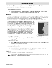
... on the Map screen. Changing the Map Scale 1. The Main Menu will be displayed by the detailed map, the map information from the detailed map will appear. The Options Menu appears. Navigation Screens The Magellan Triton has six navigation screens and a Satellite Status screen. Map Screen The Map screen displays ... the navigation screen you have an optional Detail Map loaded and are two cursors that can be displayed on the map as a blue dashed line (color is a north indicator that indicates the Position Destination Line. Map Cursors There are in an area covered by ...
... on the Map screen. Changing the Map Scale 1. The Main Menu will be displayed by the detailed map, the map information from the detailed map will appear. The Options Menu appears. Navigation Screens The Magellan Triton has six navigation screens and a Satellite Status screen. Map Screen The Map screen displays ... the navigation screen you have an optional Detail Map loaded and are two cursors that can be displayed on the map as a blue dashed line (color is a north indicator that indicates the Position Destination Line. Map Cursors There are in an area covered by ...

Manual - English
Page 47
...to enter the first few characters for a route you can use the arrow keys to be loaded for the area that the waypoints are displayed or search for .) 5. Select Delete Route. 9. From the Map screen press MENU. 2. If needed , change the order that the route is in elevation ...or name. Press the PAGE / GO TO button twice. 8. Press the right arrow. 7. Select Route. 4. Confirm the route duplication. 10. From the Map screen press MENU. 2. Viewing a Route's Vertical Profile The Vertical Profile screen graphically displays the changes in for the vertical profile to see the elevation for...
...to enter the first few characters for a route you can use the arrow keys to be loaded for the area that the waypoints are displayed or search for .) 5. Select Delete Route. 9. From the Map screen press MENU. 2. If needed , change the order that the route is in elevation ...or name. Press the PAGE / GO TO button twice. 8. Press the right arrow. 7. Select Route. 4. Confirm the route duplication. 10. From the Map screen press MENU. 2. Viewing a Route's Vertical Profile The Vertical Profile screen graphically displays the changes in for the vertical profile to see the elevation for...

Manual - English
Page 53
... you will need to select the category to view the waypoints in your current location or do not have any detailed maps loaded, Background Maps will be the only option.) 5. Select Nearest to narrow down the search. Select Go To. 3. Places are finished viewing the Place waypoint... if you want to switch between the Information Page and the Options Page. 9. Select the waypoint name from your Magellan Triton. From the Select Map display, select the detailed map. (If you want the waypoints listed by the distance from the list of waypoints. Selecting search brings up the ...
... you will need to select the category to view the waypoints in your current location or do not have any detailed maps loaded, Background Maps will be the only option.) 5. Select Nearest to narrow down the search. Select Go To. 3. Places are finished viewing the Place waypoint... if you want to switch between the Information Page and the Options Page. 9. Select the waypoint name from your Magellan Triton. From the Select Map display, select the detailed map. (If you want the waypoints listed by the distance from the list of waypoints. Selecting search brings up the ...

Manual - English
Page 54
... can enter the first few characters for a waypoint you want to do not have any detailed maps loaded, Background Maps will be the only option.) 5. Select if you do a search. From the Map screen, press MENU. 2. Press ENTER to switch between the Information Page and the Options Page....available. 7. Press ESC when you want the waypoints listed by the distance from the list of waypoints. From the Select Map display, select the background map or the detailed map for .) 8. Select the subcategory or All Subcategories if available. 7. Use the PAGE / GO TO button to switch...
... can enter the first few characters for a waypoint you want to do not have any detailed maps loaded, Background Maps will be the only option.) 5. Select if you do a search. From the Map screen, press MENU. 2. Press ENTER to switch between the Information Page and the Options Page....available. 7. Press ESC when you want the waypoints listed by the distance from the list of waypoints. From the Select Map display, select the background map or the detailed map for .) 8. Select the subcategory or All Subcategories if available. 7. Use the PAGE / GO TO button to switch...

Manual - English
Page 55
... Set Times for a Place Waypoint 1. Select if you want the waypoints listed by the distance from your current location or do not have any detailed maps loaded, Background Maps will be the only option.) 5. Select the category or All Categories. 6. Press the green checkmark when done. Viewing Best Fish and Hunt Times for.... 13. Select Local Info. 11. Select the date displayed at the top of the display to use the calendar to do not have any detailed maps loaded, Background Maps will be the only option.) 5. From the...
... Set Times for a Place Waypoint 1. Select if you want the waypoints listed by the distance from your current location or do not have any detailed maps loaded, Background Maps will be the only option.) 5. Select the category or All Categories. 6. Press the green checkmark when done. Viewing Best Fish and Hunt Times for.... 13. Select Local Info. 11. Select the date displayed at the top of the display to use the calendar to do not have any detailed maps loaded, Background Maps will be the only option.) 5. From the...


